Last update
2025
Summary
The Exmoor Mires project is part of a wider Upstream Thinking programme initiated by the local water company South West Water (SWW) to use land management to tackle problems of water quality and quantity across South-west England. The benefit to SWW is in potentially reducing the costs of water treatment. Demonstration of success will allow SWW to approach the regulator (OFWAT) for permission to develop PES schemes to deliver these benefits in future. The Exmoor Mires project involves peatland restoration through blocking historic drainage ditches with a target of restoring 2000 ha by 2015. The primary benefits of the project have been to reduce runoff (32%) and increase water storage (additional 364 m3/ha). The success of the project has been aided by the land ownership and public engagement by the Exmoor National Park Authority and support from other public agencies and research from universities.
Position
Latitude
51.129
Longitude
-3.757
Project
NWRM
National Id
UK_04
Installation date
2006-ongoing
Implementation Status
Contact
Alistair McVittie, SRUC
RBD code
UK08
Transboundary
0
Photo gallery
Location of the project
The Exmoor Mires project is located in Exmoor National Park, Somerset, mainly on upland blanket bogs near Simonsbath, Wheddon Cross, and Exe Head. Key restoration sites include Hoar Oak, Chains Barrow, Blackpitts, and Furzehill Common. Areas are near minor roads like B3223 and B3358 but are largely remote moorlands in river headwaters.
NUTS Code
UKK2 - Dorset and Somerset
Project's objectives
Restore 2,500 hectares of peatland by 2020.
Achieve a 30% reduction in peak flow rates in restored areas.
Increase water retention capacity by 20% in targeted sites.
Achieve a 30% reduction in peak flow rates in restored areas.
Increase water retention capacity by 20% in targeted sites.
Involved Partners
| Authority type | Authority name | Role | Comments |
|---|---|---|---|
Climate zone
cool temperate moist
Temperature
8°C
Precipitation
1581
Annual rainfall range
1500 - 1800 mm
Runoff
1327
Runoff coefficient
0,84
Runoff range
450 - 600 mm
Elevation range
420 m
Vegetation class
The area is characterized by blanket bog vegetation, including species such as Sphagnum mosses and cotton grass, indicative of wetter conditions.
Water bodies: Ecological Status
Good
Water bodies: Chemical Status
Good
Water quality status
Prior to restoration, the peatlands were degraded due to historical drainage, leading to increased runoff and potential water quality issues.
Project scale
Meso
Project scale specification
Work spans multiple Exmoor headwaters (e.g., Exe headwaters/The Chains), with ~3,000 ha restored by 2020 and ongoing regional programme (SWPP) across several moors
Performance timescale
1 - 4 years
Project area
> 2,000
Lifespan
The restoration measures are designed to be long-term, with benefits expected to persist for decades, assuming proper maintenance and management.
The project is grounded in principles of ecosystem restoration, aiming to re-establish natural hydrological functions, enhance biodiversity, and contribute to climate change mitigation through carbon sequestration.
The restoration measures are designed to handle typical rainfall events in the region, aiming to restore natural hydrological regimes rather than targeting specific storm events.
Design capacity description
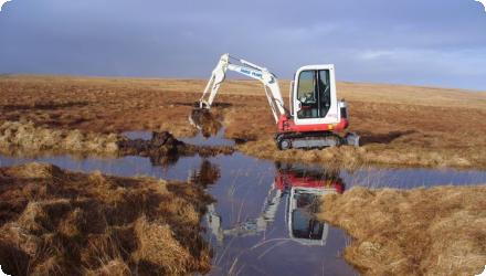
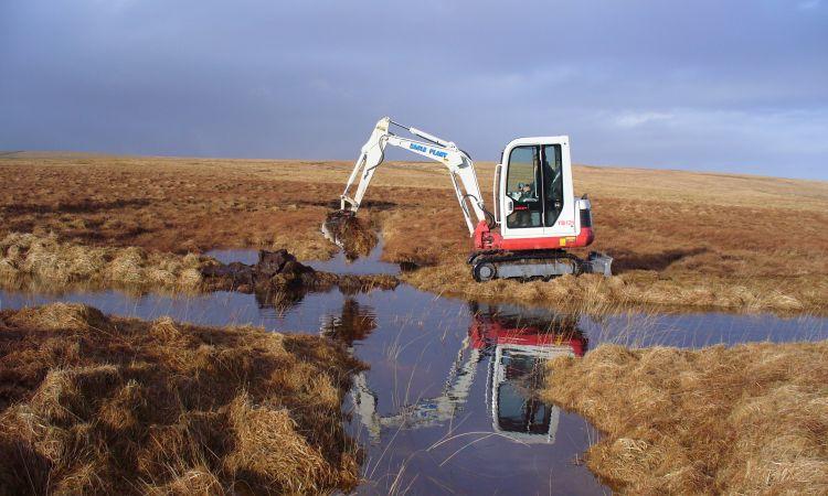
The restoration involves blocking drainage ditches to raise water tables, re-wetting peat soils, and promoting the growth of peat-forming vegetation.
Challenges include the site's steep slopes and thin peat layers, which require careful planning and adaptation of restoration techniques to ensure effectiveness and prevent further degradation.
The project has involvement from a number of key stakeholder groups including South West Water (as part of its Upstream Thinking Programme), academic researchers, land owners (Exmoor National Park Authority). There has also been a history of re-wetting projects in the the surrounding area.
Negative influence effectiveness
The thin peats and steep slopes of Exmoor required adaptations in restoration techniques, such as using natural on-site materials for dam construction.
Total cost
£ 10,500,000
Costs total information
2006–2010 (EMRP): precursor phase reviewed; Ofwat (PR09) allowed SWW to spend up to £3.8m on Dartmoor & Exmoor catchment management (not Exmoor-only).
2010–2015 (Mires on the Moors): SWW £2.2m committed.
2010–2020 (Exmoor Mires Partnership): ~£4.5m to restore ~3,000 ha; funders: SWW, Environment Agency, Natural England. Public sources do not break down shares beyond this.
2021–2025 (SW Peatland Partnership covering Exmoor, Dartmoor, Bodmin, West Penwith): £13m programme incl. £9m from Natural England’s Nature for Climate Peatland Grant Scheme plus match from SWW, Duchy of Cornwall, National Trust, Cornwall Council. (Regional, not Exmoor-only; no Exmoor split published.)
Costs investment information
The land is under Higher Level Stewardship scheme and would be eligible for measures including "Maintenance of Moorland†Ÿ (HL9) or "Restoration of Moorland†Ÿ (HL10) at £40/ha (€47.2/ha at £1 = €1.18) plus a £10/ha (€11.8/ha) supplement for "Moorland re-wetting†Ÿ (HL13). This would either be paid under the HLS agreement or by the project (i.e. no cost to the land owner)
Costs land acquisition information
Land is owned by the Exmoor National Park and tenanted for farming
Financing authorities
Type of funding
Private funds
Policy context
The Exmoor Mires Restoration Project addresses the degradation of peatlands due to historical drainage and land-use changes. This degradation leads to increased runoff, reduced water quality, and loss of biodiversity. Digging of drainage ditches over decades has resulted in drying out of blanket peat bog, re-wetting is being undertaken through blocking drains to increase retention of water and carbon.
Land ownership
Exmoor National Park Authority owns much of the restoration land; areas are tenanted for farming. Work also involves other local landowners/commoners.
Community involvment
Yes
Design consultation activity
| Activity stage | Name | Key issues | Comments |
|---|---|---|---|
|
Implementation phase
|
Project website
|
http://upstreamthinking.org/index.cfm?articleid=8699 (no longer available)
|
|
|
Implementation phase
|
Online, classroom and outdoor educational materials and activities
|
http://www.exmoormires.org.uk/index.cfm?articleid=9633 (no longer available)
|
|
|
Implementation phase
|
Outdoor events and activities
|
http://www.exmoormires.org.uk/index.cfm?articleid=11396 (no longer available)
|
|
|
Implementation phase
|
Volunteering opportunities
|
http://www.exmoormires.org.uk/index.cfm?articleid=10819 (no longer available)
|
Policy target
| Target purpose |
|---|
|
Runoff control
|
|
Increase Water Storage
|
|
Pollutants Removal
|
|
Oher Societal Benefits
|
Target Remarks
The project's design focuses on re-wetting drained peatlands to restore their natural hydrology, which helps in controlling runoff and peak flows. This restoration enhances water storage capacity and supports diverse habitats, contributing to biodiversity. Secondary benefits include improved groundwater recharge, reduction in pollutant loads, and erosion control. Additionally, the project offers societal benefits like carbon sequestration and recreational opportunities.
Policy pressure
| Pressure directive | Relevant pressure |
|---|---|
|
WFD identified pressure
|
Good ecological and chemical status of water bodies.
|
|
WFD identified pressure
|
Good ecological and chemical status of water bodies.
|
Pressures remarks
The project aligns with multiple EU directives, addressing pressures related to water quality, flood risk, and habitat conservation. Restoration efforts contribute to meeting the objectives set by these policies.
Policy impact
| Impact directive | Relevant impact |
|---|---|
|
WFD identified impact
|
Improved water quality and ecological status of water bodies.
|
|
Floods Directive identified impact
|
Enhanced flood risk management through natural retention.
|
|
Other EU
|
Habitats Directive : Restoration of priority habitats leading to increased biodiversity.
|
Requirement directive
| Requirement directive | Specification |
|---|
Contractual arrangements
1
| Arrangement type | Responsibility | Role | Name | Comments |
|---|---|---|---|---|
|
Contractual agreement
|
Memorandum of agreement concerning the Exmoor Mires Project
|
Part of wider plan
0
Wider plan type
| Wider plan type | Wider plan focus | Name | Comments |
|---|---|---|---|
|
Regional
|
Water
|
Upstream Thinking
|
Upstream Thinking is an initiative run by South West Water in South West England that aims to improve water quality and quanitity through improved land management in upper catchments. The benefit to SWW is in potentially reducing the costs of water treatment. Demonstration of success will allow SWW to approach the regulator (OFWAT) for permission to develop PES schemes to deliver these benefits in future.
|
|
Regional
|
Environment & Biodiversity
|
South West Peatland Partnership (SWPP)
|
A regional initiative coordinating peatland restoration efforts across South West England.
|
|
National
|
Environment & Biodiversity
|
National Peatland Strategy
|
Focuses on the protection and restoration of peatlands for climate regulation, water management, and biodiversity in the UK.
|
|
Local
|
Exmoor National Park Management Plan
|
Local plan emphasizing the conservation of natural resources, including peatlands, within the park.
|
Measurements of discharge, water table levels, dissolved organic carbon (DOC), water color, and pH.
Catchment outlet
Water quantity:
In-situ depth to water table measurements at > 200 locations across 8 "experimental pools" and within 3 headwater catchments.
Discharge quantified for 7 drainage features and at 3 catchment outlets.
Meteorological variables are recorded at each catchment.
Water quality:
Storm-flow sampling using ISCO pump sampler
DOC measurements (UV spectrophotometer)
Colour: UV - vis Spectrometer (Abs 400nm; Fulvic/Humic ratio (E4/E6))
pH
Assessed through hydrological monitoring (e.g., water table measurements, discharge) and water quality analyses (e.g., DOC, pH).
South West Water report that reduced silt level in water could reduce treatment costs for drinking water by 20%.
Research is ongoing with respect to agricultural impacts. These include sward quality for grazing (potential for higher and more uniform water table to improve dry matter and digestability, metabolisable energy and crude protein levels) and levels of parasites (reduction in tick numbers at one restored site; reduced habitat suitability for the snail host of liver fluke). Impacts of re-wetting on cattle movements are to be studied
Research is ongoing with respect to agricultural impacts. These include sward quality for grazing (potential for higher and more uniform water table to improve dry matter and digestability, metabolisable energy and crude protein levels) and levels of parasites (reduction in tick numbers at one restored site; reduced habitat suitability for the snail host of liver fluke). Impacts of re-wetting on cattle movements are to be studied
Hydrological effects
The project has restored the natural hydrology of degraded blanket bogs by blocking drainage ditches, leading to increased water retention and a rise in water table levels. This has resulted in enhanced water storage and a more stable hydrological regime.
Information on retained water
By blocking over 100 km of ditches with more than 10,000 dams, the project has re-saturated the bogs, allowing them to hold more water and release it more slowly. This has improved the bogs' capacity to retain water, acting as natural reservoirs.
Increased water storage
364
Increased water storage unit
m3/ha
Information on increased water storage
Based on 260,000 cubic meters of additional water storage in peat over the first restored area of 714 ha.
Peak flow rate reduction
32
Peak flow rate reduction unit
%
Information on Peak flow rate reduction
Storm flow production is reduced to approximately 32% of its pre-restoration level, following catchment restoration
Maintenance baseflow
1
Information on Maintenance baseflow
Base flow volumes vary between approximately 201% and 48% of pre restoration levels
Reduced depth to groundwater level
0,0184000004082918
Information on Reduced depth to groundwater level
Average decrease in depth to groundwater (during non rainfall-runoff event periods) with a range of 0.0103 to 0.0265 m
Reducing flood risks quantity
The re-wetted peatlands act as natural sponges, absorbing excess rainfall and reducing the risk of downstream flooding.
Ecosystem erosion control
0
Information on Water quality overall improvements
Carbon/DOC: total carbon yield reductions up to ~50% reported; DOC/colour issues targeted as a utility driver.
Soil quality overall soil improvements
N/A info
1
The project has improved habitats for various species, including sphagnum mosses, which are crucial for peat formation. The wetter conditions have also benefited wetland flora and fauna, enhancing overall biodiversity in the area.
Ecosystem impact climate regulation
Impact on GHGs (net emissions and storage) including soil carbon
Information on Ecosystem impact GHG soil carbon
Restored peatlands sequester carbon, reducing net greenhouse gas emissions. The project helps in maintaining and enhancing soil carbon stocks.
Key lessons
This is an ongoing project of moorland rewetting involving blocking of existing drainage ditches, as such monitoring of impacts on water quality, water flow, habitats and greenhouse gases has not been completed. However, preliminary results for water quality and quantity are encouraging with storm water run-off reduced by 32% and the average depth to the water table level reduced. The project is a continuation of an exiting partnership between the regional water company (South West Water), the Exmoor National Park Authority (also the landowner) and national agencies (Natural England, Environment Agency, English Heritage). There is also academic input (Universities of Exeter and Bristol) into monitoring of inputs.
Success factor(s)
| Success factor type | Success factor role | Comments | Order |
|---|---|---|---|
|
Successful coordination between authorities
|
main factor
|
<p>The Exmoor Mires project follows on from previous rewetting of 313ha of moorland on Exmoor by a partnership of the same stakeholders between 2006 and 2010 - 'Exmoor Mire Restoration Project'</p>
|
1
|
Driver
| Driver type | Driver role | Comments | Order |
|---|---|---|---|
|
Organisation committed to it
|
main driver
|
National and regional commitments to climate change mitigation and habitat restoration. The degraded peatlands contributing to carbon emissions and biodiversity loss.
|
1
|
Transferability
The project's methodologies are transferable to other degraded peatlands, provided there's stakeholder buy-in and appropriate funding. Key considerations include understanding local hydrology, land-use history, and socio-economic contexts. Flexibility in approach and continuous monitoring are essential for success elsewhere.
Basin characteristics influence
The site's steep slopes and thin peat layers necessitated tailored restoration techniques, such as using locally sourced materials for dam construction.
Source(s)
English