Last update
2025
Summary
The project was implemented in 2009 by the Russenski Lom Nature Park Directorate, Club “Friends of Russenski Lom” and WWF, with the support of the Ministry of Culture, and was funded by WWF and the German Federal Ecological Foundation (DBU). Applying the principle “more space for the river – more safety for people”, it aimed to open sections of the dykes, allowing water to re-enter the floodplain, reducing road flooding risk, and restoring river–floodplain connectivity.
Since then, the intervention has been embedded in the park’s long-term management framework. In 2022, an updated 10-year Management Plan for the park was formally adopted, prepared under the Interreg V-A Romania–Bulgaria “GreenManagement” project. This plan integrates the earlier floodplain restoration into a wider strategy for Natura 2000 site conservation, hydromorphological monitoring, sustainable tourism, and cross-border cooperation. WWF has also reported complementary river restoration measures within the park, including barrier removals and the installation of a fish pass to improve longitudinal connectivity and support protected fish species. These actions consolidate the ecological and hydrological benefits initiated in 2009, now supported by structured governance, mapping tools, and systematic monitoring.
Since then, the intervention has been embedded in the park’s long-term management framework. In 2022, an updated 10-year Management Plan for the park was formally adopted, prepared under the Interreg V-A Romania–Bulgaria “GreenManagement” project. This plan integrates the earlier floodplain restoration into a wider strategy for Natura 2000 site conservation, hydromorphological monitoring, sustainable tourism, and cross-border cooperation. WWF has also reported complementary river restoration measures within the park, including barrier removals and the installation of a fish pass to improve longitudinal connectivity and support protected fish species. These actions consolidate the ecological and hydrological benefits initiated in 2009, now supported by structured governance, mapping tools, and systematic monitoring.
Position
Latitude
43.6983
Longitude
25.97972
Project
NWRM
National Id
Bulgaria_03
Installation date
2009-03
Implementation Status
Contact
REC
RBD code
BG1000
Transboundary
0
Photo gallery
Location of the project
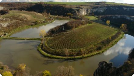
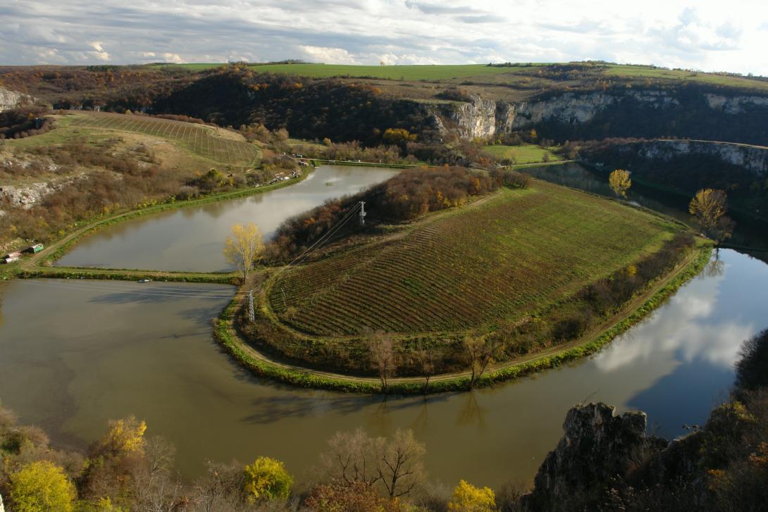
The site is within the Russenski Lom Nature Park, Ruse Province, near the village of Ivanovo.
NUTS Code
BE32 - Prov. Hainaut
Project's objectives
Primary goal: Apply the principle “more space for the river – more safety for people” by opening sections of existing dykes to restore river–floodplain connectivity.
Flood risk reduction: Reduce flooding on nearby roads by allowing water to spread into the floodplain rather than being constrained by dykes.
Hydrological restoration: Reconnect the Russenski Lom river with its natural floodplain to improve flow dynamics.
Biodiversity support: Enhance habitats for riparian and aquatic species by increasing lateral connectivity.
Community benefit: Improve safety and reduce damage from high water events.
Involved Partners
| Authority type | Authority name | Role | Comments |
|---|---|---|---|
Climate zone
cool temperate dry
Temperature
12
Precipitation
525
Annual rainfall range
300 - 600 mm
Runoff
0,80
Runoff coefficient
0,5
Runoff range
600 - 750 mm
Elevation range
42
Slope range
5.0
Vegetation class
Riparian forests dominated by Populus alba, Salix alba, Alnus glutinosa.Alluvial meadows.Reedbeds (Phragmites australis) in wetter zones.
Water bodies: Ecological Status
Bad
Water bodies: Chemical Status
Failing to achieve good
Water quality status
Pollution from untreated urban wastewater entering the rivers. Diffuse agricultural pollution (nutrients, pesticides). Illegal waste disposal in and near the riverbed. Illegal waste disposal in and near the riverbed. Overextraction of inert materials .
Project scale
Meso
Project scale specification
The project targets a defined section of the Russenski Lom Nature Park, specifically the “Lomovete” protected area and its floodplains along the Cherni, Beli, and Malki Lom rivers, near Ivanovo in Ruse Province. It covers multiple kilometres of river and adjacent habitats within a sub-basin of the Danube, and is part of broader regional management and cross-border cooperation (GreenManagement project), but does not span an entire national catchment. It addresses hydromorphological restoration, fish passage, and habitat conservation at a regional river-floodplain scale rather than at a single small site.
Performance timescale
1 - 4 years
Area subject to Land use change or Management/Practice change (ha)
3
Size
2
Size unit
km
Design capacity description
N/A info
It is a Nature park
Dyke was broken by high waters at 3 spots - thus the weak spots indicated naturally and then used to design sluices
Costs total information
N/A info
Costs investment information
N/A info
Costs maintenance information
Less than 1000
Financing authorities
Type of funding
Other
Type of funding
Private funds
Type of funding
Other
Comments
GreenManagement project
Policy context
River was trained by dyke; Frequent flod events - water overflow the dyke at peak levels and remains on the arable lands
Community involvment
No
Design consultation activity
| Activity stage | Name | Key issues | Comments |
|---|
Policy target
| Target purpose |
|---|
|
Runoff control
|
|
Peak-flow reduction
|
|
Oher Societal Benefits
|
Policy pressure
| Pressure directive | Relevant pressure |
|---|
Policy impact
| Impact directive | Relevant impact |
|---|
Requirement directive
| Requirement directive | Specification |
|---|
Contractual arrangements
0
| Arrangement type | Responsibility | Role | Name | Comments |
|---|
Part of wider plan
1
Wider plan type
| Wider plan type | Wider plan focus | Name | Comments |
|---|---|---|---|
|
Management plan of Rusenski Lom Nature park
|
Monitoring is required under the Natura 2000 framework and the park’s Management Plan, with regular assessment of habitat condition, key species populations, and pressures.
Habitat quality: extent, structure, and function of riparian forests, alluvial meadows, and reedbeds.
Species presence and abundance: especially target species under the Habitats and Birds Directives (e.g., otter Lutra lutra, certain bird species, protected fish).
Pressures: evidence of pollution (wastewater inflow, agricultural runoff), illegal waste deposits, and hydromorphological changes.
Hydrological regime: qualitative assessment of flow connectivity between river and floodplain, presence of blockages or erosion.
BG1RL00001MS020
BG1RL00001MS010
Maintenance
Maintenance consists mainly of preserving floodplain and riparian habitats through vegetation management, removal of invasive species, and preventing illegal activities such as waste dumping and unregulated construction.
Catchment outlet
Regular visits
N/A info
N/A info
Retained water
3000
Retained water unit
m3/month
Ecosystem erosion control
1
Information on Ecosystem erosion control
Protect the structure and substance in soil and prevent landslides ??
Water quality overall improvements
Neutral impact-no change in WQ status
Soil quality overall soil improvements
Neutral impact-no change in SQ status
1
Improve the habitat of the black stork
Ecosystem impact climate regulation
Not relevant for the specific application
Ecosystem provisioning services
1
Information on Ecosystem provisioning services
Improved flood control on private arable lands
Key lessons
The restoration project is successful because the habitat restoration objectives are not in contradiction with the interests of the local population and authorities. The measure allows improved flood control on agriculture lands and improves the road safety.
Success factor(s)
| Success factor type | Success factor role | Comments | Order |
|---|---|---|---|
|
Attitude of decision makers
|
main factor
|
1
|
|
|
Existing staff and consultant knowledge
|
main factor
|
2
|
|
|
Financing possibilities
|
secondary factor
|
3
|
|
|
Available support tools
|
secondary factor
|
4
|
Driver
| Driver type | Driver role | Comments | Order |
|---|---|---|---|
|
Other
|
main driver
|
Continuous flooding during heavy rainfall ???
|
1
|
English