Last update
2025
Summary
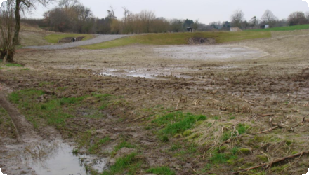
Upstream of ’s-Gravenvoeren (Voeren), the Horstergrub measure keeps muddy runoff in the valley with an earthen dyke/dams, and farmland was shifted from maize to grassland to curb erosion. Within the cross-border Aquadra programme (2009–2013), works were delivered: in Dec 2012 an earthen dam and two erosion ponds were built in the Horstergrub to trap water and sediment before it reaches the village. The Horstergrub is a dry valley that only flows during rain; Voeren’s 2023/24 Hemelwater & Drought Plan lists an existing “erosiebuffer op Horstergrub” (~30,600 m²). Since 2022–2024, the Dutch water board notes standard-compliance issues on the Horstergrub in Mheer and is developing a new rainwater buffer near the border at Pletsgatweg (Mesch), in coordination with VMM, with a throttled outlet to limit peaks. Together, these actions complement the original NWRM goal of slowing runoff and reducing sediment delivery to ’s-Gravenvoeren, while addressing today’s cross-border flood-risk needs.
Position
Latitude
50.7585409
Longitude
5.7720445
Project
NWRM
National Id
Belgium_02
Installation date
2008
Contact
Heather Williams and Chris Binje, AMEC
RBD code
BEMaas_VL
Transboundary
1
Photo gallery
Location of the project
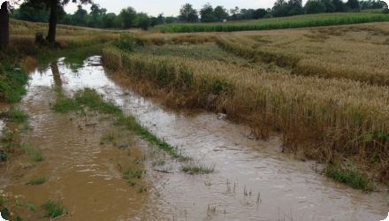
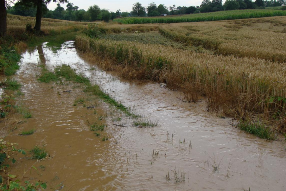
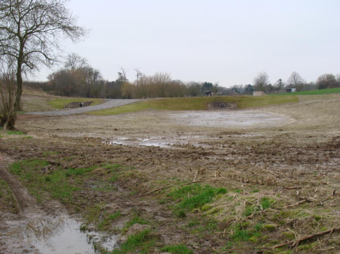
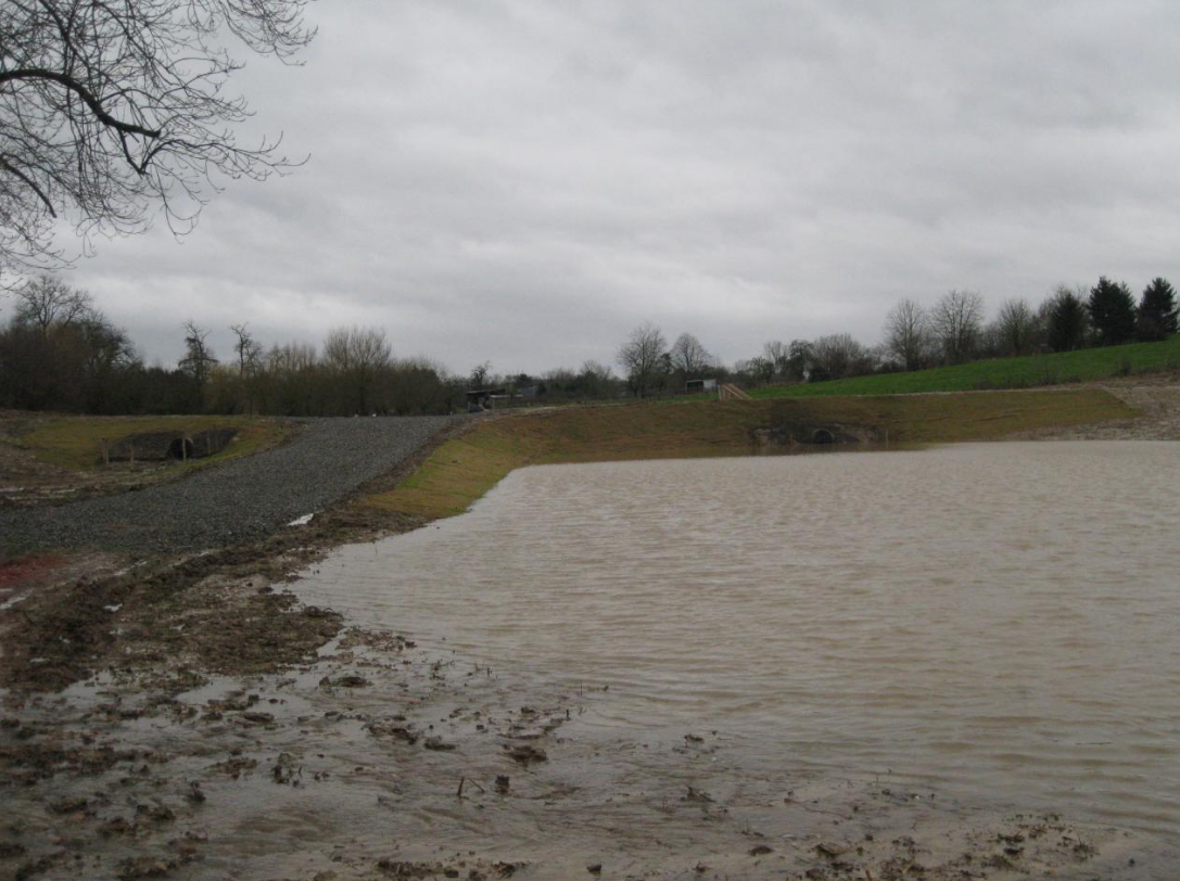
The site is located in a rural location on the Horstregrub stream, upstream of the village of Gravenvoeren. It is located in the catchment of the River Voer, which is itself a tributary of the Meuse.
NUTS Code
BE22 - Prov. Limburg (BE)
Project's objectives
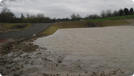
Retain mud/erosion consequences by a horizontal dyke/dam and ponds at the valley bottom to hold water longer, reduce runoff & sediment toward downstream villages, and convert maize to grassland upstream; storage ~6,000 m³.
Involved Partners
| Authority type | Authority name | Role | Comments |
|---|---|---|---|
Climate zone
cool temperate moist
Temperature
10
Precipitation
800
Elevation range
92 m
Slope range
5-10%
Vegetation class
Hilly grasslands. At the wider Voerstreek Natura 2000 site, land use is dominated by agricultural areas (significant cropland/grassland) with large patches of deciduous woodland on valley slopes (≈42% of the SBZ area in the forest inventory).
Water bodies: Ecological Status
Poor
Water bodies: Chemical Status
Failing to achieve good
Water quality status
Key pressures in the Voer sub-basin: diffuse agricultural pollution & sediment (erosion/mudflows) and incomplete sanitation, with several reaches rated moderate–insufficient; sanitation & erosion control are priorities.
Project scale
Micro
Project scale specification
It’s a site-specific intervention in one dry valley branch (Horstergrub): an earthen dyke/dam with two erosion ponds plus land-use change on nearby fields.
Performance timescale
Immediate
Design capacity description
Measures installed: earthen dam + two erosion ponds; upstream conversion maize → grassland to reduce erosion.
Design capacity of the retention pond is 6.000 m3.
Design capacity of the retention pond is 6.000 m3.
There are no specific constraints to the application of this measure type, which is a simple method of runoff capture.
The Horstergrub is a dry valley (not a classified watercourse) that conveys intense runoff during rain and points directly toward the village hence repeated water/mud problems.
The Horstergrub is a dry valley (not a classified watercourse) that conveys intense runoff during rain and points directly toward the village hence repeated water/mud problems.
Total cost
€ 55,000
Costs investment
55000
Financing authorities
Type of funding
Local funds
Compensations
1
Compensations basis information
In order to receive the necessary subsidies from the Flemish authorities, the agreements still have to be approved by the municipal council.
Compensations scheme information
Some compensation was agreed with the landowner to change the landuse to pasture. Compensation was provided to local farmers in exchange for maintaining the areas surrounding the established grassed buffer zones.
Policy context
In the area of the project a lot of erosion happens during heavy rainfall events. As there is no natural stream or other way of transporting rainwater away, surface runoff occurs over the area, causing mudstreams or floodings in the village downstream. Measures to prevent this from occurring were therefore needed.
Land ownership
Private farmland. Works were built under an agreement with the landowner (compensation for converting maize to grassland); Commune of Voeren initiated/financed and appointed VMM to execute.
Community involvment
No
Design consultation activity
| Activity stage | Name | Key issues | Comments |
|---|
Policy target
| Target purpose |
|---|
|
Erosion Control
|
|
Runoff control
|
Policy pressure
| Pressure directive | Relevant pressure |
|---|
Policy impact
| Impact directive | Relevant impact |
|---|
Requirement directive
| Requirement directive | Specification |
|---|
Contractual arrangements
0
| Arrangement type | Responsibility | Role | Name | Comments |
|---|
Part of wider plan
1
Wider plan type
| Wider plan type | Wider plan focus | Name | Comments |
|---|---|---|---|
|
Regional
|
Water
|
Aquadra
|
Aquadra had as a purpose to strive for clean water conditions across regional and national borders. Partners in the project included the Dutch and Belgians provinces of Limburg, province of Liege, regional water authorities from these 3 provinces and the German city of Aachen.
|
Multiple organizations, including the Province of Limburg, the Flemish Environment Agency (VMM), and local municipalities, are involved in overseeing the implementation and monitoring of these measures.
Regular visual assessments are conducted to identify any signs of structural damage, sediment accumulation, or vegetation issues in the erosion control structures, such as the retention ponds and dikes.
Unknown
Information on retained water
6000 m3 total storage volume
Information on increased water storage
6000 m3 total storage volume, compared to zero previously
Ecosystem erosion control
1
Information on Ecosystem erosion control
Slows runoff, allowing sediment deposition and reducing the risk of further erosion downstream
Information on Ecosystem erosion control impact
Not quantified
Water quality overall improvements
Positive impact-WQ improvement
Information on Water quality overall improvements
Reduction in transfer of sediment and associated nutrients or other pollutants downstream, by allowing sediment deposition in the storage area
Soil quality overall soil improvements
Positive impact-SQ improvement
Information on Soil quality overall soil improvements
The Voeren area is an area with significant erosion problems, causing mudstreams in the center of the village of Gravenvoeren. As a result of this NWRM, less good quality soil will be eroded and transported downstream.
1
The landuse upstream has been changed from crops to grassland, which allows an increase in diversity compared to the previous land use.
Ecosystem impact climate regulation
Not relevant for the specific application
Key lessons
Low-cost measures can make a significant local improvement to runoff and sediment load problems.
Success factor(s)
| Success factor type | Success factor role | Comments | Order |
|---|
Driver
| Driver type | Driver role | Comments | Order |
|---|---|---|---|
|
Past flooding events
|
main driver
|
Past flooding events have occurred in the village of Gravenvoeren
|
1
|
Transferability
Highly transferable to small, erosion-prone headwaters with dry valleys (“holle wegen”) and arable slopes, common across Flanders, Wallonia, the Netherlands, and similar loess landscapes. But success hinges on sizing, outlet control, land agreements, and maintenance.
Source(s)
English