Last update
2025
Summary
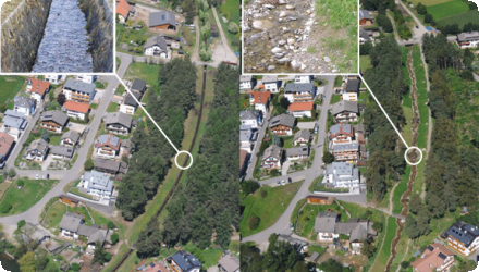
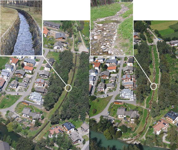
This case study focuses on the restoration of the Aurino stream as part of a 20-year management plan (1999–2020), during which several interventions were implemented between Molini di Tures and Brunico. The main goal was flood protection, alongside ecological restoration.
Since 2003, several restoration and requalification interventions have been carried out on areas of public water property. The measures included widening the riverbed, reactivating side channels, lowering embankments, and restoring sediment dynamics. Specific interventions carried out under these objectives included: the widening of the Aurino river section at Molini II; requalification of the Aurino at Molini; requalification of the Stockweiher; requalification of the Gatzaue area; requalification of the Schmidt-Aue floodplain; and requalification of the lower course of the Rio di Fontecervo. Additional efforts included the creation of the San Giorgio River Park “Beach”; widening of the “Im Sack” meander; and widening of the “Raut” area, including the oxbow lake. Complementary awareness and recreational initiatives such as Views on the Aurino, the Experience the Aurino trail (Lower Aurino river recreation), and the river recreation area in Eile further supported the engagement and multifunctional use of the restored areas. Most works were conducted on public land; however, one intervention (Gatzauer/Gais Lot III) required compensation due to the use of private property.
Stakeholder involvement from farmers to local communities was crucial. Negotiations helped balance environmental goals with agricultural needs, leading to broad acceptance. The restored floodplains improved retention capacity (from 17% to 20%), effectively reducing flood risk, as proven during heavy rainfall in 2020 with no reported damages.
The project is still ongoing and there is work being done every year. There is also a monitoring program which is being repeated around every 7 years. Until today the project still proves its effectiveness. Naturally there is some deterioration for example due to the missing sediment input in the catchment. However, to this day there were no restoration works needed for any of the revitalization measures. However, in the near future there will surely be some work done to fight deteriation due to the limited land availability.
Position
Latitude
46.8488
Longitude
11.9562
Project
NWRM
National Id
Italy_01
Installation date
1999-2020
Implementation Status
Contact
Gloria De Paoli, ACTeon
RBD code
ITA
Transboundary
0
Photo gallery
Location of the project
The project covers the area of the Aurino stream, from its confluence with the Rienza river in the locality of Brunico (km 0.0) to just above the confluence with the Rio Selva dei Molini stream in the locality of Molini di Tures (m 14.9). The boundaries of the project area include all the perifluvial strips falling within the area of influence of the Aurino. The affected municipalities are those of Campo Tures, Gais and Brunico.
NUTS Code
ITH1 - Provincia Autonoma di Bolzano/Bozen
Project's objectives
The initial objectives were a modern approach on flood protection and nature conservation.
Involved Partners
| Authority type | Authority name | Role | Comments |
|---|---|---|---|
Climate zone
cool temperate moist
Temperature
8.2°C
Annual rainfall range
600 - 900 mm
Remarks runoff imperviousness
Imperviousness is mainly due to infrastructure, roads, and buildings in towns; large stretches of the catchment remain permeable.
Elevation range
828,4m
Slope range
1-2%
Vegetation class
Mainly agricultural land (meadows, pastures, cornfields etc.). Agricultural land accounts for around 55% of the area while riparian forests account for 13% (vegetation analysis 2018)
Water bodies: Ecological Status
Good
Water bodies: Chemical Status
Good
Water quality status
Main pressures in the area are agriculture and hydropeaking
Project scale
Meso
Performance timescale
> 20 years
Project area
540 ha
Area specifications
The area covered by the project is composed of the following parts:
1. Agriculture: 300 ha 55%
2. Water body: 50 ha 9%
3. Riparian forest: 70 ha 13%
4. Other (settlements, industrial zones, infrastructure etc.) 23%
1. Agriculture: 300 ha 55%
2. Water body: 50 ha 9%
3. Riparian forest: 70 ha 13%
4. Other (settlements, industrial zones, infrastructure etc.) 23%
Area subject to Land use change or Management/Practice change (ha)
5.4 km
Size unit
km
Lifespan
Undefined, as long as possible
The project was designed in 2000 by a commission composed of various stakeholders, including municipalities, state authorities, and representatives of associations for agriculture, environmental protection, and tourism.
The project was divided into 3 phases:
1. Assessment of the current situation
2. Development of vision (catalogue of measures/action plan)
3. Implementation of these measures
The principle behind the project was to take continuous small steps, based on a clear vision, to improve the ecological state of the lower Aurino.
The preliminary study (1999) identified the maximum flow rates of the river with respect to different return times (10, 30, 100 and 150 years). The hydraulic model allowed for the identification of areas more vulnerable to floods up to a return time of 150 years.
Design capacity description
The preliminary study (1999) identified the maximum flow rates of the river with respect to different return times (10, 30, 100 and 150 years). The hydraulic model allowed for the identification of areas more vulnerable to floods up to a return time of 150 years.
The Aurino is an alpine stream, and thus it flows in a very narrow valley with high competition over land use by the different sectors (agriculture, industry, residential). As a consequence, land prices are amongst the highest in Italy. This means that these interventions, which reclaim land to the river bed, are necessarily confronted with these limiting issues: (i) interventions are limited in the sense that they cannot bring the ground water level back to its original level, as this would imply a loss of agricultural land; and (ii) due to land prices, interventions were mostly implemented on public land.
Although the river bed is incised, the lower Aurino course still kept its meanders, and even before interventions it could have been considered one of the best conserved river stretches in the Bozen province. The good ecological condition in which the area was in already before the restauration works was a favourable circumstance and was taken into account during the planning process.
The project profited heavily from the site, as it is one, if not the river with the most public land surrounding it. Also, the ecological condition of the surrounding areas played a key role, as they were in a good state in comparison to other areas in South Tyrol. Furthermore, the river itself wasn’t as morphologically degraded as other rivers in South Tyrol (e.g. no channelization and few bank protection measures such as revetments). Summarizing, the lower Aurino and its surroundings were in a relatively good shape already before the revitalization measures.
The project profited heavily from the site, as it is one, if not the river with the most public land surrounding it. Also, the ecological condition of the surrounding areas played a key role, as they were in a good state in comparison to other areas in South Tyrol. Furthermore, the river itself wasn’t as morphologically degraded as other rivers in South Tyrol (e.g. no channelization and few bank protection measures such as revetments). Summarizing, the lower Aurino and its surroundings were in a relatively good shape already before the revitalization measures.
Positive influence effectiveness
High public land availability; existing meanders; stakeholder cooperation; strong institutional coordination.
Negative influence effectiveness
High land prices and land use competition; limits to restoring groundwater levels due to agricultural constraints.
Total cost
€ 4,000,000
Costs total information
In total the province spent around 600.000€ for planning works (monitoring etc.) and around 3.400.000€ for the implementation of the measures.
Costs per site:
Campo Tures (all three lots): 345.000 €
Gatzaue/ Gais (all four lots): 917.000 €
Brunico: 1.193.000 €
Costs per site:
Campo Tures (all three lots): 345.000 €
Gatzaue/ Gais (all four lots): 917.000 €
Brunico: 1.193.000 €
Financing authorities
Type of funding
Sub-national funds
Comments
Budget of the Special Enterprise for River Regulation and Land Protection, which is a body of the Autonomous Province of Bozen. The Province allocates funds to the Special Enterprise for the protection and safety of residential areas, and in turn the Special enterprise allocates part of these funds to restoration interventions.
Type of funding
Private funds
Comments
Environmental compensation payments
Type of funding
Other
Comments
fishery fund
Type of funding
Other
Comments
water fess for the use of public waters for irrigation, power production etc.
Compensations
1
Compensations basis information
In most cases, the measures were implemented on public land (property of the state or the municipality).
In Gatzaue/ Gais Lot III most of the land (0.6 ha) was privately owned. Once the measures were implemented, the landowner received in exchange other parcels. Some parcels on the old Aurino river bed were in fact still inventorized as "demanio idraulico" (state hydraulic property), but they cannot be considered anymore as part of the hydraulic private property as they are completely covered by woodland. These parcels were given to the private landowner as an exchange, whereas the formerly private parcels used for implementing the measures passed onto the hydraulic public property as they are now occupied by the river.
In Gatzaue/ Gais Lot III most of the land (0.6 ha) was privately owned. Once the measures were implemented, the landowner received in exchange other parcels. Some parcels on the old Aurino river bed were in fact still inventorized as "demanio idraulico" (state hydraulic property), but they cannot be considered anymore as part of the hydraulic private property as they are completely covered by woodland. These parcels were given to the private landowner as an exchange, whereas the formerly private parcels used for implementing the measures passed onto the hydraulic public property as they are now occupied by the river.
Policy context
The main objective of the interventions is the improvement of riparian natural environments, coupled with protection against floods. More in detail, the interventions were aimed at tackling: (i) almost total disappearance of islands and gravel areas; (ii) dramatic reduction of flooding areas. Another major objective is to raise the groundwater level, which has significantly reduced over time. As a result of the former (i) the river has damaged longitudinal hydraulic works, especially near bridges; (ii) riparian forests are now rarely flooded, and this disturbs ecological dynamics. However, a lower groundwater table allowed the expansion of agricultural areas, and this had to be taken into account when designing and implementing the measures - i.e. bringing back the ground water level back to the original level would not have been a desirable outcome for farmers.
The issue described above are due to (i) hydromorphological interventions on Aurino's effluents, and on 40% of the Aurino stream: this led to the reduction of solid transport; and (ii) intense gravel mining along the lower stream course (in the 70's).
The issue described above are due to (i) hydromorphological interventions on Aurino's effluents, and on 40% of the Aurino stream: this led to the reduction of solid transport; and (ii) intense gravel mining along the lower stream course (in the 70's).
Land ownership
Most of the area is privately owned. However, the water bodie and some of its surroundings are part of the “Öffentliches Wassergut/Demanio idrico” (public water domain).
Community involvment
Yes
Design consultation activity
| Activity stage | Name | Key issues | Comments |
|---|---|---|---|
|
Design phase
|
Several activities targeting local communities and stakeholders (e.g. negotiations with farmers, educational activities in schools)
|
In the Beginning there was a lack of understanding for the vision and the proposed measures. Through public information activities and specific school projects we were able to improve the understanding of the community. The clear and continuous dialogue helped to gain the trust of the stakeholders, specifically the landowners.
|
informing and involving local communities and key stakeholders was the key to successful implementation (see e.g; negotiations with farmers);
|
|
Other
|
Stakeholders yearly meeting
|
Once a year there is a meeting of all stakeholders where problems are being discussed, and new measures are being created.
|
Policy target
| Target purpose |
|---|
|
Peak-flow reduction
|
|
Groundwater Recharge
|
|
Improved Biodiversity
|
Policy pressure
| Pressure directive | Relevant pressure |
|---|
Policy impact
| Impact directive | Relevant impact |
|---|
Requirement directive
| Requirement directive | Specification |
|---|
Contractual arrangements
1
| Arrangement type | Responsibility | Role | Name | Comments |
|---|---|---|---|---|
|
Other
|
Negotiation with local farmers
|
Agreement with local farmers: if the groundwater table exceeds the threshold agreed upon, the Province committed to intervene to bring the level below the threshold
|
Part of wider plan
0
Wider plan type
| Wider plan type | Wider plan focus | Name | Comments |
|---|---|---|---|
|
Regional
|
Water
|
Lower Aurino Management Plan
|
Management Plan for the Aurino river developed by the Autonomous Province of Bozen
|
|
Project-based
|
Water
|
River Basin Agenda
|
All interventions are part of the Lower Aurino Management Plan, and they are also included in the project "River Basin Agenda" (Alpine Space - Interreg IIIB) aimed at addressing common challenges of alpine river basins.
Essential functions and use of river basins are flood protection und flood retention, extensive agriculture and forestry, recreational use, groundwater protection and nature conservation. Modern river basin management therefore means conciliating these requirements at the best possible way. River basin management as it is understood within the project group of the RBA, deals with coordination of procedures regarding flood protection and land use planning in Alpine valley floors. The river basin management plays particularly a crucial role in the spatial development of endangered, intensively used valley sites. In the frame of the planning process it is important to integrate as many participants as possible, e.g. municipalities, departments, interested and concerned people, etc. At the regional level, the interventions aimed at addressing both flood control and the enhancement of riparian environments. |
The last monitoring was done in 2018 (between 1999 and 2018 there were no observations), 2025 will have new monitoring results.
Parameters monitored continuously or periodically:
Groundwater levels (most critical)
Channel pattern and planform
Connection to groundwater (hydrogeological parameters)
Riparian shore zone structure and condition
Piezometer levels (regularly)
Invertebrate populations (biological indicators)
Fish and bird populations (ecological status)
Possibly some socio-economic indicators related to agricultural water use, but no formal monitoring plan on socio-economic parameters noted.
In-Stream
Piezometers . Quantitative and qualitative monitoring of channel pattern, riparian zones, and aquatic fauna were performed at different sites before and after intervention.
Monitoring combined field observations, piezometric measurements, and biodiversity surveys (fish, birds, invertebrates).
Use of before-after comparison of channel morphology and riparian vegetation structure.
Social surveys and visitor engagement used to assess recreational and educational impacts.
Collaboration with universities provided scientific support for impact evaluation.
Some ecological indicators were measured through direct observation and sampling of habitats.
Combination of quantitative measurements (water levels, channel width, species counts) and qualitative assessments (habitat quality, vegetation structure).
Use of GIS and aerial imagery for mapping channel changes and riparian vegetation.
Biological surveys for fish, birds, amphibians, and benthic invertebrates.
Use of GIS and aerial imagery for mapping channel changes and riparian vegetation.
Biological surveys for fish, birds, amphibians, and benthic invertebrates.
Administrative and implementation costs were tracked via the Special Enterprise's budget allocations.
Compensation costs for private land acquisition or use were recorded separately.
No detailed cost-benefit analysis was reported, but financing focused on maintaining flood safety and ecological improvements.
Cost-effectiveness partly assessed by combining ecological benefits with social benefits (recreation, education).
This project allowed to create a better understanding of modern flood protection and nature conservation. Furthermore, more people have built a relationship with the landscape.
Hydrological effects
The water retention has increased by 17% for floods with a 30-year return period and about 20% for a flood with a 100-year return period
Information on Ecosystem flood control volume
Based on hydraulic modeling and terrain surveys, the natural flood detention capacity of the Aurino valley floor was quantified as follows:
• 350,000 m³ for a 30-year return period (Tr30) flood event
• 720,000 m³ for a 100-year return period (Tr100)
• 1,190,000 m³ for a 300-year return period (Tr300)
These volumes represent the natural flood storage in excess of standard retention volumes and play a key role in flood mitigation, especially for downstream settlements such as San Giorgio and Stegona. The 30-year event attenuation reaches approx. 10 m³/s, and for the 300-year event up to 60 m³/s. This natural capacity should be preserved by avoiding further urban development in flood-prone areas and can be enhanced through controlled floodplain management and minor terrain reconfigurations.
Information on Water quality overall improvements
The first RBMP for the Eastern Alps RBD classifies the Aurino stream in good (2003) and high (2004) ecological status (NWRM implementation in the period 2003-2004). Water quality after measure implementation was not measured
The measures improved the river bed structure, created differentiated habitats and created areas with different flow speed. As a result, the fish population improved considerably, both in terms of size and ratios among main species.
Despite the morphological improvements the animal populations didn’t grow and repopulate the restored habitats as expected.
Despite the morphological improvements the animal populations didn’t grow and repopulate the restored habitats as expected.
Ecosystem impact climate regulation
Not relevant for the specific application
Key lessons
Participatory planning and communication activities are crucial for successful implementation, evidenced by negotiations with farmers regarding groundwater levels and land use.
Combining ecological restoration with recreational improvements (e.g., access to the water, benches, and paths) increases social acceptance.
Flexibility in plans is necessary when addressing stakeholder concerns, such as modifying the original plan at S. Giorgio/Brunico to avoid large forest clearing.
Success factor(s)
| Success factor type | Success factor role | Comments | Order |
|---|---|---|---|
|
Communication activities
|
main factor
|
<p>Participatory planning and communication activities: informing and involving local communities and key stakeholders was the key to successful implementation (see e.g. negotiations with farmers).</p>
|
2
|
|
Existing institutional framework
|
main factor
|
<p>The Autonomous Province of Bozen has, as its name suggests, almost full autonomy when it comes to land and river management. This means that it has full responsibility and control over its territory and water bodies, so it can autonomously plan and implement interventions. In addition, it is one of the richest local administrations in Italy, and thus it has funds available. The measures were fully implemented by the Province, which has all the necessary equipment, and nothing was externally contracted or subcontracted: this allowed for keeping the costs down. Interventions were managed by a "strong" coordinator, who had everything under control.</p>
|
3
|
|
Financing possibilities
|
<p>The Autonomous Province of Bozen has, as its name suggests, almost full autonomy when it comes to land and river management. This means that it has full responsibility and control over its territory and water bodies, so it can autonomously plan and implement interventions. In addition, it is one of the richest local administrations in Italy, and thus it has funds available. The measures were fully implemented by the Province, which has all the necessary equipment, and nothing was externally contracted or subcontracted: this allowed for keeping the costs down. Interventions were managed by a "strong" coordinator, who had everything under control.</p>
|
4
|
|
|
Attitude of decision makers
|
main factor
|
<p>The Autonomous Province of Bozen has, as its name suggests, almost full autonomy when it comes to land and river management. This means that it has full responsibility and control over its territory and water bodies, so it can autonomously plan and implement interventions. In addition, it is one of the richest local administrations in Italy, and thus it has funds available. The measures were fully implemented by the Province, which has all the necessary equipment, and nothing was externally contracted or subcontracted: this allowed for keeping the costs down. Interventions were managed by a "strong" coordinator, who had everything under control.</p>
|
5
|
Driver
| Driver type | Driver role | Comments | Order |
|---|---|---|---|
|
main driver
|
The main objective of the interventions is the improvement of riparian natural environments, coupled with protection against floods. More in detail, the interventions were aimed at tackling: (i) almost total disappearance of islands and gravel areas; (ii) dramatic reduction of flooding areas. Another major objective is to raise the groundwater level, which has significantly reduced over time. As a result of the former (i) the river has damaged longitudinal hydraulic works, especially near bridges; (ii) riparian forests are now rarely flooded, and this disturbs ecological dynamics. However, a lower groundwater table allowed the expansion of agricultural areas, and this had to be taken into account when designing and implementing the measures - i.e. bringing back the ground water level back to the original level would not have been a desirable outcome for farmers.
The issue described above are due to (i) hydromorphological interventions on Aurino's effluents, and on 40% of the Aurino stream: this led to the reduction of solid transport; and (ii) intense gravel mining along the lower stream course (in the 70's). |
1
|
Flexibility adaptability
The project showed adaptability by modifying interventions (e.g., downsizing interventions to avoid cutting large riparian forest areas for public acceptance).
Negotiations with farmers influenced design to balance ecological goals and agricultural needs.
The approach demonstrates good transferability due to its focus on participatory planning and balancing ecological with agricultural and recreational needs.
Communication campaigns and involvement of local stakeholders are key transferable aspects.
Transferability
This type of project was already applied to other river areas in South Tyrol in form of river managements plans. However, the possibility to implement measurements is strongly dependent on the availability of land. Also it is very cost intensive to aquire land for restauration measurements. To succesfully implement such measurements we have to be determined, stay patient and have a bit of luck to achieve a good result.
Therefore, most rivers with a similar concept have not been restaurised to the extend to which the lower Aurion has been renaturalized. The only comparable project is the restauration of the Mareiter Bach/Rio di Mareta, where the first measurements were implemented in 2010 and have since been monitored and worked on
Therefore, most rivers with a similar concept have not been restaurised to the extend to which the lower Aurion has been renaturalized. The only comparable project is the restauration of the Mareiter Bach/Rio di Mareta, where the first measurements were implemented in 2010 and have since been monitored and worked on
English