Last update
2025
Summary
Measures to attenuate runoff were installed in the small Belford catchment, in northeast England, in order to reduce the risk of flooding to the village downstream. The installations involved a network of small measures to capture and delay runoff from the rural catchment, including detention basins and overland flow features, as well as sediment capture measures to improve water quality.
However, since the implementation, the features were not maintained by the landowner, and have been then decommissioned. The measures that were implemented are no longer functional.
However, since the implementation, the features were not maintained by the landowner, and have been then decommissioned. The measures that were implemented are no longer functional.
Position
Latitude
55.5986067185
Longitude
-1.83175794041
Project
NWRM
National Id
United Kingdom_01
Installation date
2011
Implementation Status
Contact
Katie Hill and Heather Williams, AMEC
RBD code
UK03
Transboundary
0
Photo gallery
Location of the project
Belford Burn catchment (~5.7–6 km²), Northumberland, UK, focused near Belford village.
NUTS Code
UKC2 - Northumberland and Tyne and Wear
Project's objectives
The main objective is to reduce flood risk to Belford village downstream. Some of the measures also contribute to sediment retention, which has the potential to contribute to the waterbody achieving good ecological status, and help towards maintaining the quality of the downstream SPA.
Involved Partners
| Authority type | Authority name | Role | Comments |
|---|---|---|---|
Climate zone
cool temperate moist
Temperature
9
Precipitation
750
Runoff
400
Runoff coefficient
0,4
Runoff range
450 - 600 mm
Elevation range
55
Slope range
5-10%
Vegetation class
Rural with predominantly pasture and cultivated grasslands.
Water bodies: Ecological Status
Moderate
Water bodies: Chemical Status
Good
Water quality status
The waterbody is not at Good Ecological Status. There are high sediment and phosphorus levels from intensive agriculture.
Project scale
Meso
Project scale specification
5.7–6 km² catchment. Multiple small-scale runoff attenuation features (bunds, leaky dams, ponds) distributed across the catchment.
Performance timescale
< 1 year
Project area
570 ha
Lifespan
Many features (e.g., ponds, leaky dams) expected to last decades with maintenance.
Based on Catchment Systems Engineering (CSE): manipulating flow at source, using distributed RAFs, focusing on multiple benefits (flooding, water quality, biodiversity). Involves community engagement, adaptive management, cost-efficiency, and leveraging natural processes.
Relatively short, high-intensity rainfall events. 5-17 year return period.
Design capacity description
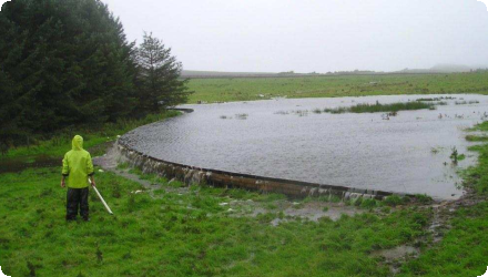
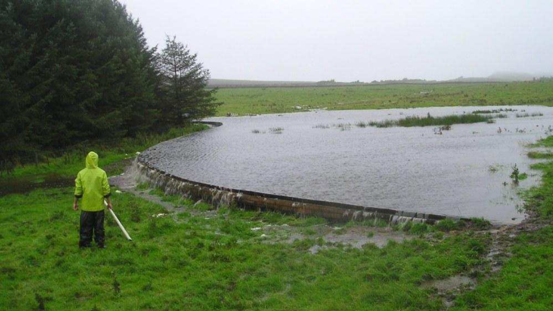
For this site a suite of small NWRMs are operating in combination, with a total storage of 9-10,000 m3.
The following are approximate maximum storage capacities used on the Belford site, per individual feature:
Overland flow interception: 1000 m3
Online ditch features: 150 m3
Offline ponds: 3000 m3
Large woody debris: 150 m3
Opportunistic measure sites: 3000 m3
As an example, one of the off line ponds implemented (approximately equivalent to 60x20m rectangle) stores approximately 3mm of runoff for 0.74km2 (however it is noted that in some cases the storage capacity reduced over time due to sediment buildup, which is an important consideration for maintenance). A further example was a small 1.2m dam that stores 500m3 of flow.
These types of measures are most suited for rural headwater catchments. The benefits can most directly be seen in terms of flood protection for small settlements a short distance downstream, although will continue to have a cumulative benefit in the whole downstream catchment.
Modelling has indicated that the measures are most effective for short, high intensity rainfall events, which suggests that they could also be applicable in drier climates, where intense rainfall events are experienced. They are effective for managing overland flow runoff, so may be less suitable in groundwater-dominated areas (although even in those situations could still have benefit for high intensity events that generate overland flow).
Fish passage requirements can pose a constraint to the type of NWRM applied. Fish passage can be restricted by online structures (e.g. in stream dams) so they are more suited to small watercourses and ditches where fish passage is not important or the watercourse runs dry during the summer months.
The upstream characteristics of the watercourse (small channels) are ideal for implementation to these types of NWRM features as the scale of flows to be retained is not large and the size of the feature can be kept small, resulting in little loss of agricultural land
Positive influence effectiveness
Small flashy catchment enables quick response.
Negative influence effectiveness
Short time of concentration, limited runoff attenuation features scalability.
Total cost
~£450k
Costs total information
Phase 1 : ~£350k Local Levy (North East RFCC). Of this, ~£250k was used by the Environment Agency (EA) to commission Newcastle University (monitoring, modelling, design, engagement, letting works); the ~£100k remainder went to village works (bridge wall repair, drainage upgrades).
Phase 2 (2013): ~£100k Local Levy for ~10 additional RAFs.
Phase 2 (2013): ~£100k Local Levy for ~10 additional RAFs.
Costs investment
€ 120,000
Costs investment information
Construction costs only. 85,000 - 120,000 euros
Approximate costs per feature:
Barriers: €900-2,000 per m (dependent on material)
Woody debris: €120-1,200 per feature
Offline Ponds: €6,000 per feature (less if multiple ponds in close proximity)
Approximate costs per feature:
Barriers: €900-2,000 per m (dependent on material)
Woody debris: €120-1,200 per feature
Offline Ponds: €6,000 per feature (less if multiple ponds in close proximity)
Costs land acquisition information
No land aquisition was required as all measures were in-channel or on buffer strips, causing minimal disturbance to farmers' land.
Costs operational information
Small costs are envisaged, but no quantative indication available. Management of features is done by combination of Environment Agency, Northumberland Rivers Trust and Natural England.
Costs operation maintenance information
Due to the nature of the NWRM, operational costs will be minimal, but there are maintenance requirements. There is also some additional cost associated with optimisation following implementation, e.g. Raising the outflow from a pond to increase its capacity
Costs maintenance information
Sediment clearance is important e.g. At sediment traps. Maintenance is also required of log/debris dams, which may need repairing or replacing over time
Costs disposal decommissioning information
Minimal costs
Information on Economic costs - income loss
There is some minor land loss associated with the construction of ponds. However any costs associated with this could be offset in part by benefits of sediment recovery and re-use. No quantification is avaialble
Financing authorities
Type of funding
National funds
Type of funding
Sub-national funds
Compensations
1
Compensations annual information
A one-off payment was made by the Environment Agency to famers for having access to the site for measure installation.
Policy context
Belford village has a long history of flooding, often causing damage to properties. An Environment Agency flood defence pre-feasibility study concluded that traditional flood defences were not suitable for Belford because of the high cost, lack of space for flood walls and banks, and the small number of properties at risk, resulting in an unfavourable cost-benefit assessment. There was a desire to deliver an alternative catchment based and more cost-effective solution to the problem. In addition to this, the waterbody is not at Good Ecological Status, and sediment retention and nutrient management as part of the NWRM programme help to address this.
Land ownership
Private farmland: the upstream catchment is privately owned by three main landowners; farmers provided land access
Community involvment
Yes
Design consultation activity
| Activity stage | Name | Key issues | Comments |
|---|---|---|---|
|
Design phase
|
meetings
|
Decision support tools were made availalble to the famers to understand the underlying issues and provide them with adequate knowledge to participate in formulating a solution
|
|
|
Other
|
Effectiveness understanding
|
Famers were taking photographs and videos during flood events of the NWRM during flood conditions.
|
|
|
Implementation phase
|
Field trips
|
Field trips were organised for villagers to see the wrok being undertaken
|
Policy target
| Target purpose |
|---|
|
Runoff control
|
|
Peak-flow reduction
|
|
Increase Water Storage
|
|
Pollutants Removal
|
Policy pressure
| Pressure directive | Relevant pressure |
|---|---|
|
WFD identified pressure
|
Pressure from poor water quality due to diffuse agricultural pollution.
|
|
Floods Directive identified pressure
|
Recurrent local flooding highlighted post-2007 floods.
|
|
Other non-EU
|
Defra 25-Year Plan: Emphasises nature-based flood solutions.
|
|
Other non-EU
|
Climate change policy (UKCCC): Rising peak flows demand NBS.
|
Pressures remarks
The Belford project directly responds to both water quality and flood control policy gaps. The Pitt Review, Environment Agency mandates, and UKCCC pressures pushed the shift to upstream natural flood management. The project acts as a response to local-scale issues under broader EU/UK frameworks.
Policy impact
| Impact directive | Relevant impact |
|---|---|
|
WFD identified impact
|
Reduced sediment and phosphorus improves water body status.
|
|
Floods Directive identified impact
|
Local flood risk reduction meets directive’s preventive aim.
|
|
Other non-EU
|
UK Defra Plan: Supports sustainable, nature-based mitigation.
|
|
Other non-EU
|
National Flood Strategy: Enhances resilience to climate-driven events.
|
Impact remarks
Belford’s success in reducing flood peaks and pollution aligns directly with WFD and Floods Directive goals. The evidence of cost-effectiveness and multifunctionality supports uptake under national planning and environment policy strategies.
Requirement directive
| Requirement directive | Specification |
|---|---|
|
WFD-mitigation of significant pressure
|
Diffuse pollution
|
|
WFD-achievement of good ecological status
|
|
|
Floods Directive-mitigating Flood Risk
|
|
|
Floods Directive-establishing adequate PoM
|
Requirement directive remarks
RAFs in Belford serve multiple WFD aims, especially reducing sediment/nutrient loading and enhancing ecological integrity. They contribute to Floods Directive goals by mitigating peak flow.
Contractual arrangements
0
| Arrangement type | Responsibility | Role | Name | Comments |
|---|
Part of wider plan
1
Wider plan type
| Wider plan type | Wider plan focus | Name | Comments |
|---|---|---|---|
|
Local
|
Water
|
Defence strengthening in Belford Village
|
This strategy was 1 of 3 strategies (including the natural water retention measures implementation) where the Environment Agency funded investigation and strengthening wirk to be undertaken at the existing "structural" flood defences within Belford Village.
|
|
Local
|
Urban
|
Sewer upgrade
|
This strategy was 1 of the 3 strategies (including the NWRM implementation) where Northumbrian Water upgraded sewers to improve the resiliance and prevent surface water flooding.
|
At the start of the project there was no hydrometry present within the catchment. The Environment Agency has installed a telemetered gauging station within Belford village for Flood warning purposes. In addition they have installed a tipping bucket rain gauge at a farm to help with flood warning predictions. Alongside this Newcastle university installed a raingauge and three flow gauging stations, which will help understand the impact of the features on the flood peak hydrograph as a flood moves through the catchment.
A grab sampling campaign began in 2009 to characterize the sediment and nutrient regime and identify locations contributing to elevated levels of agricultural diffuse pollution.
Four auto samplers were deployed at two online pond features, one upstream and one downstream of each feature. This was to understand if they were retaining sediments and nutrients during storm events.
Monitoring was undertaken at locations directly upstream and downstream of some natural water retention features.
Monitoring was undertaken at locations directly pstream and downstream of some natural water retention features. There is a WFD monitoring location on the Belford Burn.
Maintenance
Includes sediment removal, vegetation clearing, ensuring flow through pipes and leaky barriers.
Laboratory
For some water retention features direct comparisons were made pre and post implementation, and also upstream and downstream of individual measures. Impact assessments were undertaken at a number of the indivdiual measures using available observed data. Model interpolation was used to understand the effects of multiple measures using hydraulic modelling.
Monitoring, modelling (CityCAT)
Compared Natural Flood Management cost with conventional scheme.
There is no quantified information on the socio-economic benefits.
The use of a network of NWRMs in a rural landscape has provided a cost effective means to reduce flood risk downstream. Additional benefits include:
- Storing water in ponds on the fields removes sediment picked up by overland flow which can be returned to the farmer's field.
- Creating wetlands on some of the ponds provides new habitat for wildlife.
- The increased habitat and improved water quality is leading to an increase in the biodiversity in the catchment.
Hydrological effects
Rural attenuation features reduced peak discharge, increased flow lag time, altered surface/subsurface pathways, and encouraged floodplain connectivity, enhancing natural storage.
Information on retained water
The estimated total for the suite of NWRMs is around 10,000 cubic metres in total.
Information on increased water storage
There was no storage previously.The estimated total for the suite of NWRMs is around 10,000 cubic metres in total.
Information on runoff reduction
Little net change in total runoff
Peak flow rate reduction
35
Peak flow rate reduction unit
%
Information on Peak flow rate reduction
An individual NWRM may only provide a very small reduction in the peak flow, but in combination larger peak flow reductions can be observed. This value is for a MODELLED system representative of Belford with total storage of 19,250 cubic metres, for the reduction of peak flow at the downstream end of the network of measures: 15-30% peak flow reduction.
Maintenance baseflow
0
Information on Increased infiltration
Possible increases in infiltration due to water being retained within the upper catchment for longer before flowing downstream.
Information on Reducing flood risks, quantity
No major flooding in Belford village despite several 1:100-year events. Runoff attenuation features are effective for flash floods in small catchments.
Ecosystem erosion control
0
Information on Ecosystem erosion control
Does not directly affect erosion, but does allow sediment to be captured and re-applied to fields, resulting in lower net loss
Water quality overall improvements
Positive impact-WQ improvement
Information on Water quality overall improvements
An investigation was begun in 2009 to assess effectiveness of features to reduce losses of sediment and nutrients. Parts of the catchment already had high concentrations of SS, P and NO3. The overall, cumulative impact of all the NWRMs has been found to be difficult to prove, and to require extensive monitoring. However some findings included:
- It was identified that online ponds were not retaining pollutants during the rising limb and peak of flood events.
- Overall conclusion was that online features are functioning to reduce chronic losses of Suspended solids but are less effective in storm events.
- Different features operate to retain pollutants under contrasting flow conditions.
The study area covers the upper 50% (approximate) of the associated WFD waterbody. Therefore it is likely that the improvements identified in water quality (e.g. phosphate) due the NWRMs will contribute to overall improvements in the Ecological status of the waterbody.
- A multi stage NWRM (constructed following findings of initial NWRMs) that included a sediment trap and willow barriers works effectively to reduce sediment and nutrient losses from the catchment during storms
Water quality Improvements Phosphorus (P)
26
Water quality Improvements (P) unit
% reduction pf pollutant
Information on Water quality Improvements (P)
Multi stage NWRM measured over a 24hour storm event. 26% TP reduction, 25% soluble RP reduction
Water quality Improvements Nitrogen (N)
15
Wq Improvements n unit
% reduction pf pollutant
Information on Water quality Improvements (N)
Multi stage NWRM measured over a 24hour storm event. 15% NO3 reduction
Water quality Improvements (TSS)
After a large runoff event a retention bund. Estimated 0.99 tonnes of sediment captured (retention bund)
Multi stage NWRM over a 24hour storm event. 40% SS reduction (multi stage NWRM)
Multi stage NWRM over a 24hour storm event. 40% SS reduction (multi stage NWRM)
Water quality Improvements Total Suspended Solid (TSS)
40
Water quality Improvements (TSS) unit
% reduction pf pollutant
Soil quality overall soil improvements
N/A info
Information on Soil quality overall soil improvements
No information available. Unlikely to be significant changes
1
Overall there is increased habitat for wildlife (water features), however the overall ecological performance is difficult to quantify and required further evidence. Habitats improved include ditches, riparian zones, and wetlands. Runoff attenuation features led to increased biodiversity and ecological resilience. Stream/riparian fauna benefited, though no formal index change is reported. Soil structure and aquatic habitat quality improved
Ecosystem impact climate regulation
Not relevant for the specific application
Information on Increased Evapotranspiration
There is an increased extent of open water, but effects on evapotranspiration are likely to be insignificant since the retention times are low.
Ecosystem provisioning services
1
Information on Ecosystem provisioning services
Minor loss of agricultural land for ponds, however in most cases these are usually located on field margins, in corners or in buffer strips to minimise impact.
Some benefits from re use of sediments that are removed from the NWRMs as part of the maintenance, although further investigation is required on the effectiveness and benefits of this.
Some benefits from re use of sediments that are removed from the NWRMs as part of the maintenance, although further investigation is required on the effectiveness and benefits of this.
Key lessons
The implementation has shown how a catchment plan was effective at providing multi purpose benefits.
- A number of natural water retention measures can be used together, with the materials, location and choice of feature being dependant on local factors including land owner/farmer preferences and local terrain.
- One single natural water retention feature only has a small benefit and it is likely that a number may be required together, but this should not ignore the fact that other structural measures may also be beneficial.
- Online features are best suited to smaller channels. Scaling remains difficult beyond 10–20 km².
- The effectiveness of networks of natural water retention measures to attenuate flood depends upon the shape of the hydrograph, often being more effective for flashy short duration flood events.
- It is essential to engage stakeholders, as this will encourage uptake by farmers.
- It is crucial to build up the trust of farmers and residents from the earliest opportunity and maintain it throughout.
- Motivation of the land owner is quintessential for the longevity of measures, especially when they rely on maintenance.
- Lack of maintenance leads to the end of the measures' effectiveness.
Success factor(s)
| Success factor type | Success factor role | Comments | Order |
|---|---|---|---|
|
Attitude of relevant stakeholders
|
main factor
|
<p>Identification of a combined approach that was flexible and adapted to the local factors, and the willingness of the regulator to explore new approaches.</p>
|
1
|
|
Available support tools
|
main factor
|
<p>Availability of the tools for non-expert stakeholders to appreciate and inform solutions</p>
|
2
|
|
Communication activities
|
secondary factor
|
<p>Crucial in getting "buy -in" from land owners and famers to allow these features on the land</p>
|
3
|
|
Conducted assessments (incl. economic)
|
secondary factor
|
<p>Interest in a catchment based approach and the requirement for monitoring and modeling investigations did not prevent the work going ahead, but ensured confidence in the outcomes of the work and further understanding of effectiveness of the NWRM approach.</p>
|
4
|
|
Attitude of the public
|
secondary factor
|
<p>It helps greatly when there is good relationship between the community and farmers.</p>
|
5
|
Driver
| Driver type | Driver role | Comments | Order |
|---|---|---|---|
|
Past flooding events
|
main driver
|
Severe flood events in small settlements downstream caused this to be considered. The Environment Agency were the main driver behind this measure being implemented, looking for lower-cost solutions to enable protection of small communities where high capital expenditure could not be justified. Other 'normal'flood defence approaches failed cost benefit criteria for support, and would not be suitable within Belford due to shortage of space between the channel and nearby houses. The 'natural' approaches were financially viable for the site, and enabled storing and attenuating flows in the upstream area.
|
1
|
|
Other
|
secondary driver
|
Unsuitability of 'structural' measures in the area.
|
2
|
Flexibility adaptability
Designs adapted to terrain and local flow paths. Modular rural attenuation features allowed changes based on observation. No single blueprint - emphasis on experimental, site-specific solutions with local input and ability to evolve over time.
Transferability
Highly transferable to small, flashy rural catchments. Easy replication if landowners collaborate. Requires flexibility, site-specific design, and upfront engagement. Difficult in urban or large-scale catchments due to complexity and policy/land issues.
Basin characteristics influence
Flashy, small catchment enhances runoff attenuation features impact. Short storm response time allows effective flood peak reduction.
Cost effectiveness
Very high cost effectiveness : £200k for runoff attenuation features vs £2.5M traditional defence. Achieved ~35% local peak flow reduction.
Source(s)
English