Last update
2025
Summary
Reconstruction of dams and sluice gates, blocking of drainage ditches and creation of a hydrological network to route water from the Little Carpathians through the Šúr Fen National Nature Reserve (near Svätý Jur), funded by the LIFE programme (LIFE03 NAT/SK/000096). The works were prepared and initiated in 2003–2007 and complemented the intake built in 2001 on the Šúrsky Canal (rkm 10.197), which diverts water into the reserve when canal flow exceeds Q5 (up to ~7.4 m³/s). The Danube Flood Risk Management Plan (2015) describes a system of inverted siphons, canals and an aqueduct enabling year-round supply and water level management inside the fen. Project materials detail the refurbishment of control structures (e.g. on the Blahutov Canal), conversion of a drainage canal to irrigation, and raising water levels in the Čierna Voda to limit peat drawdown; interpretation and a nature trail were also delivered.
Since 2017–2018, management has reintroduced wood-pasture grazing in the Panónsky háj (southern part of the reserve) with local partners. Recent monitoring (2023–2024) reports marked increases in wild bee abundance in restored areas, indicating positive ecological response.
Since 2017–2018, management has reintroduced wood-pasture grazing in the Panónsky háj (southern part of the reserve) with local partners. Recent monitoring (2023–2024) reports marked increases in wild bee abundance in restored areas, indicating positive ecological response.
Position
Latitude
48.2394
Longitude
17.2261
Project
NWRM
National Id
Slovakia_05
Installation date
2007-01
Implementation Status
Contact
REC
RBD code
SK30000
Transboundary
0
Photo gallery
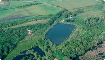
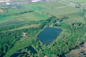
Location of the project
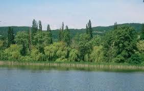
Šúr Fen National Nature Reserve sits between the towns of Svätý Jur, Vajnory (Bratislava) and Chorvátsky Grob, NE of Bratislava
NUTS Code
SK01 - Bratislavský kraj
Project's objectives
Restore the natural hydrology of Šúr Fen and reach favourable conservation status for its wetland habitats (incl. alder swamp woods).
Prepare key planning tools: elaborate a Rescue & Management Plan with management prescriptions, and enlarge the reserve (zoning/boundary update).
Rebuild and build water-control works to route Carpathian water through the reserve: reconstruction of dams/sluice gates, blocking drainage ditches, and creation of a hydrological network (incl. inverted siphons, an aqueduct, gates, supply canals and culverts).
Provide year-round water supply to internal habitats by complementing the Šúrsky Canal intake (rkm 10.197), which releases water into the reserve when canal flow exceeds Q5 (technically allowing up to ~7.4 m³/s).
Raise awareness and support acceptance: produce information/education materials, set up an exhibition, and build a nature trail.
Involved Partners
| Authority type | Authority name | Role | Comments |
|---|---|---|---|
Climate zone
warm temperate moist
Temperature
10
Precipitation
600
Runoff coefficient
0,25
Elevation range
113
Groundwater level
~0–2.7 m below surface
Vegetation class
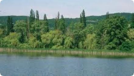
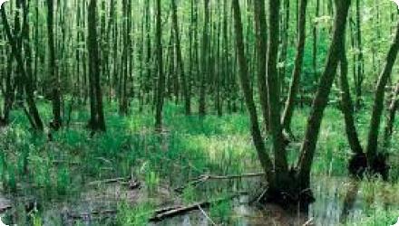
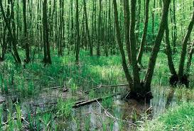
Fen alder carr (wet woodland; Carici elongatae–Alnetum) is the core and most extensive habitat, fringed by swamp/wet meadows; “Pannonian grove” (thermophilous oak) occurs locally. Predominant class: wet woodland (alder carr).
Water bodies: Ecological Status
Unknown
Water bodies: Chemical Status
Good
Water quality status
Overall high/very high; some streams show higher NO₃⁻; the Čierna Voda had the lowest quality (higher SO₄²⁻, NO₃⁻, dissolved solids, Ca). Reported pH 6.89–7.56 in streams (groundwater 7.51–8.30); conductivity 228–966 µS·cm⁻¹.
Project scale
Micro
Project scale specification
This is a site-level restoration confined to the Šúr Fen National Nature Reserve (between Svätý Jur and Chorvátsky Grob) and a short reach of the Šúrsky Canal: it reconstructs small water-control structures and reconfigures local ditches/canals (e.g., Blahutov, Chlebnický) to route water through the reserve.
Project area
1100
Area subject to Land use change or Management/Practice change (ha)
991
Antrophogenic impacts: Drainage of streams out of Sur, illegal dumps, massive urbanization, weak management (results of botanic and zoology research never applied in strategy documents), weak enforcement of legislation, no compensation of landowners, no transparent financing of restoration activities and absence of public awareness campaigns.
The locality is designated a national nature reserve
Total cost
€ 400,000
Costs total information
LIFE03 NAT/SK/000096 Total eligible budget
Financing authorities
Type of funding
EU-funds: LIFE+
Type of funding
Local funds
Comments
Part of €300,000
Type of funding
National funds
Comments
Part of €300,000
Compensations
0
Policy context
Lack of water, dry-up forest, threat and extinction of protected species and loss of function of wetland (flood protection,retain water in the landscape)
Land ownership
Mixed ownership. Municipalities (318.3 ha), the Slovak state (268.3 ha) and private owners hold only 0.07 ha
Community involvment
Yes
Design consultation activity
| Activity stage | Name | Key issues | Comments |
|---|---|---|---|
|
Publications
|
APOP has published postcards, leaflets, stickers and posters arround the municipal information centers
|
||
|
Education trail
|
The main purpose is to show the treasure of the Sur
|
Policy target
| Target purpose |
|---|
|
Improved Biodiversity
|
|
Increase Water Storage
|
|
Peak-flow reduction
|
Policy pressure
| Pressure directive | Relevant pressure |
|---|
Policy impact
| Impact directive | Relevant impact |
|---|
Requirement directive
| Requirement directive | Specification |
|---|
Contractual arrangements
0
| Arrangement type | Responsibility | Role | Name | Comments |
|---|
Part of wider plan
0
Wider plan type
| Wider plan type | Wider plan focus | Name | Comments |
|---|
Ongoing hydrological monitoring on the Šúrsky Canal is run by the Slovak Hydrometeorological Institute, while biological monitoring has been carried out through targeted studies rather than a site-wide, long-term program specific to Šúr.
Šúrsky Canal : water level (cm) and water temperature (°C)
entomological survey (Coleoptera) in 2021 assessed effects of grazing, and a Within the reserve’s pasture-forest : an entomological survey (Coleoptera) in 2021 and a 2023 study on ant communities evaluated response to restoration management - tracking species composition, richness and assemblage changes as performance indicators.
entomological survey (Coleoptera) in 2021 assessed effects of grazing, and a Within the reserve’s pasture-forest : an entomological survey (Coleoptera) in 2021 and a 2023 study on ant communities evaluated response to restoration management - tracking species composition, richness and assemblage changes as performance indicators.
Maintenance
Water-control structures are operated by the SVP, and the pasture-forest is actively maintained through clearing of self-seeded trees and seasonal grazing led by BROZ with the City of Svätý Jur and CHKO Malé Karpaty (and a local farmer).
Threats regarding the inappropriate use of non-forest land in the Nature 2000 site and the lack of awareness of the public were mitigated.
A marked nature trail (built 2006 under LIFE) provides 4.1 km/6 stops and is explicitly meant to regulate visitation and support field teaching; it’s promoted by the Bratislava Region’s tourism board. Some panels have suffered wear, with plans for renewal.
Traditional livelihoods reintroduced. From 2017, partners restarted cattle grazing in the Panónsky háj with a local farmer (Vladimír Pažitný) - a visible return of a historic silvopastoral practice that also underpins ongoing site management.
Risk reduction for adjacent land. Project materials state the right bank of the Čierna Voda was lowered/strengthened so surplus water would not endanger surrounding parcels - a local safety benefit.
Information on retained water
Controlled inundation / flood buffering enabled. Since 2001 an outlet in the left dike of the Šúrsky Canal (rkm 10.197) diverts water into the reserve when canal discharge exceeds Q5 (capacity up to 7.4 m³/s).
Water quality overall improvements
Not relevant for this application
Information on Water quality overall improvements
SHMÚ data compiled in an EIA summary show pH 7.79–8.38, conductivity 52–78 mS/m, dissolved oxygen 6.7–13.2 mg/L at “Čierna voda – Čierna voda”. These are contextual, not “impact” metrics for the project.
Soil quality overall soil improvements
Not relevant for this application
1
After clearing and re-introducing grazing (2017–2018 onward), an ant community study (2015 vs 2021) recorded a +111.95% increase in epigeic activity and a +64.71% increase in detected ant species, with 58 species documented in total across Šúr (incl. several rarities).
A conservation bulletin notes more beetle species and significantly more individuals of bark beetles on the grazed site compared with ungrazed reference, indicating a rapid assemblage shift after management restart. Quantitative counts are not provided.
A conservation bulletin notes more beetle species and significantly more individuals of bark beetles on the grazed site compared with ungrazed reference, indicating a rapid assemblage shift after management restart. Quantitative counts are not provided.
Ecosystem impact climate regulation
Not relevant for the specific application
Key lessons
Land-use planning must be built into implementation. In Šúr, urbanisation pressures and fragmented ownership collided with wetland goals; the case explicitly concludes that “land use planning should be a significant component in the implementation plan.”
Planning must analyse cross-sector consequences. The case stresses that water decisions affect other economic sectors and that these interactions should be assessed during planning—another stated lesson from the original case documentation.
Stakeholders need to know each other to align concepts and expectations. Early opposition and low acceptance were linked to weak public involvement; the case warns that initiatives without active engagement risk failure.
Technically, piggybacking on existing hydraulic infrastructure and clarifying operations helped. The outlet on the Šúrsky Canal (built 2001) and the LIFE measures (2003–2007) were later described as implemented and operated by the Slovak Water Management Enterprise—showing the value of integrating new works with existing assets and duty holders.
Communication matters. An interpretation trail and brochure were created to channel visitors and build understanding - simple tools that supported awareness and acceptance over time.
Hydrology alone is not enough; long-term habitat management is required. Re-introducing grazing in the Panónsky háj from 2018 onward illustrates how ecological outcomes depend on sustained, locally supported management partnerships.
Monitoring should serve both ecology and spatial development. The EIA recommended a robust groundwater monitoring system to inform decisions on urban expansion; in parallel, hydrometric monitoring of the Šúrsky Canal (water level and temperature) provides operational data for water management.
Success factor(s)
| Success factor type | Success factor role | Comments | Order |
|---|---|---|---|
|
Successful coordination between authorities
|
<p>The proposed zoning of the Sur Fen National Nature Reserve and identification of conservation measures in each protected zone and buffer zones provides a solid basis for transparent determination of competencies of public institutions and private landowners as well.</p>
|
1
|
|
|
main factor
|
2
|
Driver
| Driver type | Driver role | Comments | Order |
|---|---|---|---|
|
Organisation committed to it
|
main driver
|
1
|
English
LIFE03 NAT/SK/000096