Last update
2025
Summary
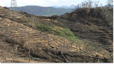
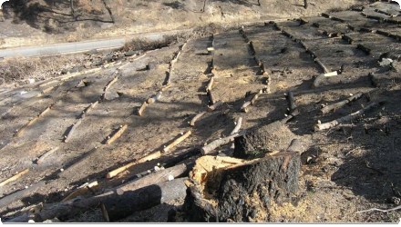
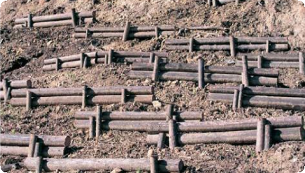
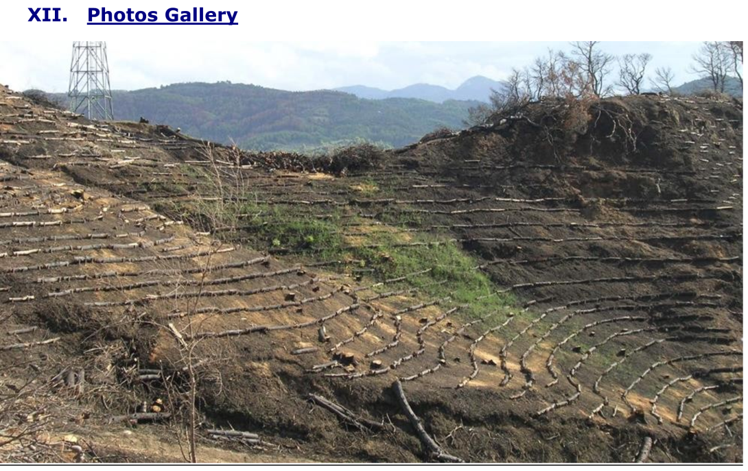
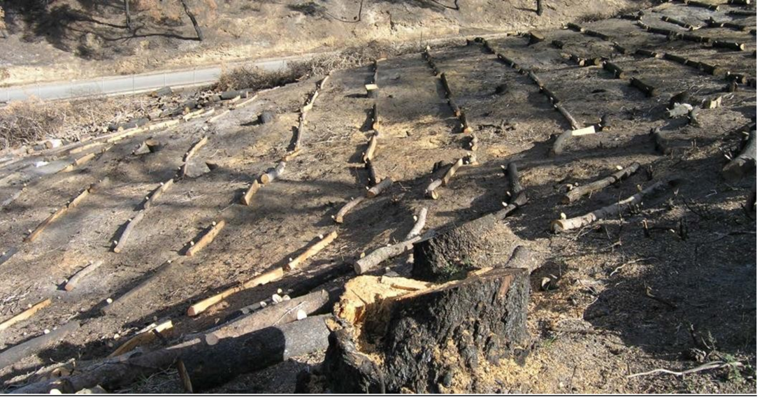
The project focuses on post-fire water retention management in the broader area of Ancient Olympia, Elia, Peloponnese, Greece. It involves afforestation of mountainous areas and the temporary installation of wooden structures using locally available timber to retain water, stabilize slopes, and reduce erosion. These natural measures aim primarily at flood control and risk mitigation, with secondary benefits for biodiversity conservation.
Recent scientific studies (2022–2025) have confirmed the effectiveness of these interventions. Field measurements showed that post-fire treatments in Olympia significantly improved soil infiltration capacity, up to 300% higher in deposition zones compared to eroded ones two years after implementation. Satellite-based erosion models (using Sentinel-2 and RUSLE) also indicated a sharp increase in soil erosion after wildfires, which was partly mitigated by restoration works that reduced erosion rates by approximately 18%. These findings demonstrate the long-term hydrological benefits of such nature-based solutions under Mediterranean conditions.
Key success factors remain the strong engagement of decision-makers, the willingness of local stakeholders, positive public perception, and the availability of expert knowledge and tools. The project is an example of adaptive, evidence-based post-fire watershed management in a culturally and environmentally sensitive region.
Position
Latitude
37.3835085
Longitude
21.378061
Project
NWRM
National Id
Greece_01
Installation date
2007-2008
Implementation Status
Contact
Maggie Kossida, IACO
RBD code
GR01
Transboundary
0
Photo gallery
Location of the project
The study area is located in Ancient Olympia, Elia, Peloponnese, Greece.
NUTS Code
EL23 - Δυτική Ελλάδα (Dytiki Ellada)
Project's objectives
Flood control : Reduce flood risk via temporary timber barriers to slow runoff velocity
Soil retention & erosion control : Retain 7.5 mm fertile soil; 2,500 m³ over 30 ha
Biodiversity conservation : Protect gene pool in riparian zones
Hydro-regulation : Reduce peak flows; sustain baseflows via afforestation
Project scale & duration : 49.5 ha affected; intervention executed Nov 2007–Feb 2008; lifespan 4–5 years
Involved Partners
| Authority type | Authority name | Role | Comments |
|---|---|---|---|
Climate zone
warm temperate dry
Temperature
16,7
Precipitation
863,049987792969
Annual rainfall range
600 - 900 mm
Runoff
675
Runoff range
600 - 750 mm
Elevation range
120
Vegetation class
The dominant vegetation type in the broader Olympia region is cultivated olive groves.
Water bodies: Ecological Status
Good
Water bodies: Chemical Status
Good
Water quality status
After wildfires the water quality was poor. As far as surface water is concerned, the wildfires have deteriorated the vegetation quality; thus the quality of water runoff was decreased.
Project scale
Meso
Project scale specification
It is a medium scale project as it involves the 4 hills around the Ancient Olympia.
49.5 ha are the area affected by the fires and restored. In particular, Kronios Hill, International Olympic Academy – Zone A, International Olympic Academy – Zone B, Zouni Hill, Kolosaka Hill.
In these areas 80-100% of the vegetation has been burned.
49.5 ha are the area affected by the fires and restored. In particular, Kronios Hill, International Olympic Academy – Zone A, International Olympic Academy – Zone B, Zouni Hill, Kolosaka Hill.
In these areas 80-100% of the vegetation has been burned.
Performance timescale
1 - 4 years
Project area
49,5
Area subject to Land use change or Management/Practice change (ha)
49,5
Lifespan
5 years, then vegetation takes over
The specific principles that were followed in the design of this application include aesthetic benefit, functionality, integrative planning, impact on public perception & acceptability, etc.
Design capacity description
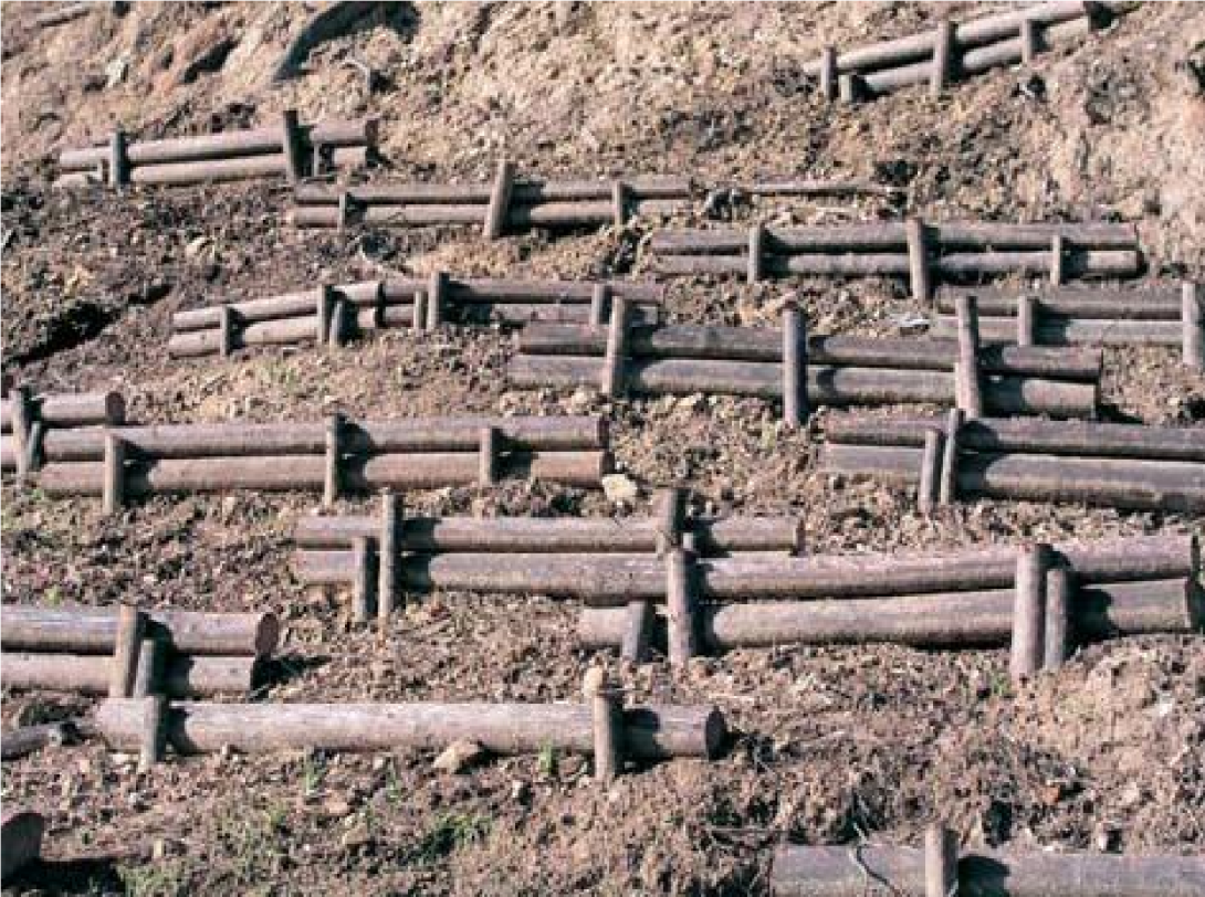
The temporary structures utilizing locally available timber have been designed to reduce the hill slopes thus attenuate the surface runoff as well as the sentiment volume. This measure enables the increase of soil moisture, water absorption, and infiltration. Additionally, it creates suitable sites for natural regeneration or technical afforestation of the burned area.
The maximum volume of runoff water that can be retained has not been assessed as this was not originally a water retention application but the restoration of the surrounding of the archeological site.
The maximum volume of runoff water that can be retained has not been assessed as this was not originally a water retention application but the restoration of the surrounding of the archeological site.
The factors that influence the selection and design of the measures is morphology, vegetation, climate and geology of the area. The morphology of the area (large slopes), increases surface runoff, leading to soil erosion and increased risk of landslides as well as increased flood events. To address this, the use of geotextile had to be implemented in most sloping and vulnerable positions. The vegetation (after the fires) has eliminated and a hydrophobic layer in the soil has been created by the combustion of organic matterwhich increases surface runoff and flood risk. The local climate, with an annual precipitation of over 1.000 mm and often intense events, also tends to increase the intensity of flood events.
The soils of the study area are also very loose and corrodible; thus vulnerable to the rainfall.
A high challenge for the temporary small structures is the hydraulic undercut.
Improving the condition of existing rainwater drainage system e.g. cleaning of the rainwater drainage system to avoid filling the road network with logging waste and increasing the flood risk.
The necessary preconditions are the climate conditions and the soil properties and characteristics.
Total cost
2,762,500 €
Costs total information
In terms of breakdown, the cost for the log barriers is not assessed in the provided information.
Costs investment
2762500
Costs investment information
This amount includes the fixed capital cost, infrastructure, construction and landscape rehabilitation.
Costs capital
1262500
Costs capital information
The irrigation system for the four hills was 464.658 € plus VAT.
Costs land acquisition
1500000
Costs land acquisition unit
€ (total value)
Costs land acquisition information
The cost for land compensations was about 1.500.000 € due to the overpriced value of the properties around the archeological site.
Costs operation maintenance information
The operational cost for irrigation as well as for pruning and fertilizer application was not assessed.
Compensations
1
Compensations total
1,500,000 €
Compensations basis information
The financial compensations were for 5-6 beneficiaries-fields with a total area of 10 hectares each. The cost per hectare for this high value area was about 20,000-30,000 €; thus the total cost for land compensations was about 1,000,000 €.
Policy context
The specific interventions aim at tackling the environmental impacts of the significant wildfires of the study area in 2007. The principal aim of the works includes reduction of soil erosion and flood management. The interventions also include burned trees harvesting and restoration actions on the existing vegetation and on the tree crops.
Land ownership
Public land. Private-owned land were bought for this project.
Community involvment
No
Design consultation activity
| Activity stage | Name | Key issues | Comments |
|---|
Policy target
| Target purpose |
|---|
|
Runoff control
|
|
Peak-flow reduction
|
|
Erosion Control
|
|
Improved Biodiversity
|
Target Remarks
The primary targets when designing this application were soil erosion management, flood control and flood risk mitigation in the context of restoring the fire affected area.
Policy pressure
| Pressure directive | Relevant pressure |
|---|---|
|
Floods Directive identified pressure
|
Other pressure contributing to flooding/flood risk
|
|
WFD identified pressure
|
Other hydromorphological alterations
|
Policy impact
| Impact directive | Relevant impact |
|---|---|
|
Floods Directive identified impact
|
Other Environmental impacts
|
|
WFD identified impact
|
Altered habitats due to hydrological changes
|
Requirement directive
| Requirement directive | Specification |
|---|---|
|
Floods Directive-mitigating Flood Risk
|
Flood risk management and flood impacts mitigation
|
|
WFD-mitigation of significant pressure
|
Mitigation of hydromorphological alterations e.g. soil erosion
|
Policy challenges requirements
Law 3199/2003 &Presidential Decree (P.D.) No. 51/2007 (protection of water resources)
Fire protection laws (Law 998/1979, P.D. 86/69, 2612/1998, 3013/2002, 3208/2003, 3511/2006 (protection of forest ecosystems, reorganization of fire department & upgrade of its mission). In terms of water policies these laws (esp. 3208/2003) are addressing the protection of the forest ecosystem including water resources.
Fire protection laws (Law 998/1979, P.D. 86/69, 2612/1998, 3013/2002, 3208/2003, 3511/2006 (protection of forest ecosystems, reorganization of fire department & upgrade of its mission). In terms of water policies these laws (esp. 3208/2003) are addressing the protection of the forest ecosystem including water resources.
Contractual arrangements
0
| Arrangement type | Responsibility | Role | Name | Comments |
|---|
Part of wider plan
0
Wider plan type
| Wider plan type | Wider plan focus | Name | Comments |
|---|
A permanent automatic meteorological monitoring station is necessary to be installed, in order to predict of the progress of the wildfire risk in the area as well as to inform the public in real time for the plant development.
Maintenance
Plants irrigation, clearing and pruning as well as bio-fertilizer application. The intensity and the frequency of the maintenance activities are related to the season the plant and the meteorological conditions in the specific area.
Unknown
Non applicable
The direct benefits include the reduction of the flood risk, the mitigation of soil erosion, the improvement of the micro-environment as well as the aesthetic restoration of the affected area.
Ancillary benefits include the increase of infiltration / percolation and recharge of aquifers; this water can be used for different purposes (e.g agriculture) as well as for ecosystem services. Also the aesthetic improvement of the area has positive societal impacts
Information on retained water
The volume of retained water was increased due to the temporary log structures as well as the improvement in the area vegitation after the afforestation
Information on increased water storage
The measures increased the retaining of water for longer period enabling the infiltration/percolation and recharge of aquifers.
Deposition zones (DZ)—areas adjacent to the timber structures—showed significantly higher unsaturated hydraulic conductivity (K) compared to erosion zones (EZ):
Wattles: DZ K was 159 % higher than EZ in 2022; 145 % higher in 2023. K increased over time: +29 % in DZ and +36 % in EZ from 2022 to 2023.
Log barriers: DZ K was 174 % higher than EZ in 2022; 243 % higher in 2023.
Log dams: DZ K was 240 % higher in 2022; 190 % higher in 2023. Both DZ and EZ saw increases in K from 2022 to 2023 (+42 % in DZ, +67 % in EZ).
Information on runoff reduction
The measures improved the runoff control as the velocity of water volume was reduced leading to decreasing the intensity and frequency of floods.
Information on Peak flow rate reduction
The peak flow rate is reduced due to the obstacle of the timber structures. This measures reduces the velocity of water volume resulting in the decrease of floods intensity.
Information on Increased groundwater level
These measures have an impact on the increase of the groundwater level due to the increased infiltration, percolation and recharge that is achieved through the slowing down of water velocity. Also vegetation succeeded in eliminating the hydrophobic layer that was created in the soil after the fires and enables the water absorption towards the aquifers.
Information on Soil moisture
These measures have a direct impact on soil moisture as the temporary timber structures enable to retain water for a longer period and inhibit the volume of runoff. Additionally, the area afforestation succeeds in eliminating the hydrophobic layer that was created in the soil after the fires and thus increased soil storage capacity.
Information on Increased soil storage capacity
The rating for hydro-seeding was 60% “excellent”.
The rating for the log erosion barriers was “excellent” or “good” in 70% of the measurements.
The rating for the log erosion barriers was “excellent” or “good” in 70% of the measurements.
Water quality overall improvements
Not relevant for this application
Information on Water quality overall improvements
Not relevant for this application
Soil quality overall soil improvements
Positive impact-SQ improvement
Information on Soil quality overall soil improvements
The measures have a direct impact on the overall soil quality as afforestation of the area succeeds in eliminating the hydrophobic layer that was created in the soil after the fires and thus increase soil storage capacity. The fires have created the porosity of the soil to decrease, thus the restoration has positive impact on the soil infiltration capacity. Also the soil is improved due to the increase of the moisture.
The total estimated soil material w/30 ha or retention of a total 7.5 mm of fertile soi, equivalent to approximately 2,500 m³ over 30 ha.
The total estimated soil material w/30 ha or retention of a total 7.5 mm of fertile soi, equivalent to approximately 2,500 m³ over 30 ha.
1
The wildfires had significant impact on the area biodiversity and the restoration measures included using species from the surrounding locations in order to restore the decreased biodiversity
Ecosystem impact climate regulation
No information available
Information on Ecosystem impact climate regulation
The micro-climate and micro-environment was positively affected by the implemented measures; however the degree of impact was not assessed
Information on Ecosystem provisioning services
Not relevant for this application
Key lessons
The Ancient Olympia case study shows that nature-based solutions can be quickly and effectively deployed in post-fire contexts. Using locally available timber, erosion control structures were installed within months after the wildfire. These low-tech interventions helped reduce surface runoff, stabilize slopes, and retain fertile topsoil across severely burned areas.
Scientific monitoring confirmed the long-term hydrological benefits of the measures. Infiltration capacity was significantly higher—up to 300%—in areas where structures were installed, even two years after implementation. This demonstrates that well-designed post-fire interventions can lead to sustained improvements in soil-water dynamics under Mediterranean conditions.
The project's design combined temporary physical structures with long-term ecological goals. Once vegetation recovered, it was expected to take over erosion control functions, making the solution both cost-effective and resilient. Supporting natural regeneration was key to amplifying long-term impacts.
Social and institutional engagement played a crucial role in implementation. The support of local authorities, the willingness of stakeholders, and the availability of expert knowledge were all essential for the project's success.
However, the lack of long-term environmental monitoring limits a full evaluation of its broader impacts. While soil retention and infiltration improvements were documented, there is little information on water quality, biodiversity, or climate regulation outcomes. Ensuring continuity in monitoring would strengthen the case for replicating such measures elsewhere.
Success factor(s)
| Success factor type | Success factor role | Comments | Order |
|---|---|---|---|
|
Attitude of relevant stakeholders
|
main factor
|
<p>The active involvement of the two Institutes was of critical importance</p>
|
1
|
|
Attitude of decision makers
|
secondary factor
|
2
|
|
|
Existing staff and consultant knowledge
|
secondary factor
|
<p>The expertise and knowledge tools of the two Institutes was important</p>
|
3
|
Driver
| Driver type | Driver role | Comments | Order |
|---|---|---|---|
|
Other
|
main driver
|
Morphology, vegetation, climate and geology of the area.
|
1
|
Transferability
This measure is highly transferable to other Mediterranean or fire-prone regions with steep terrain and erodible soils. It requires low-cost, locally sourced materials and can be rapidly implemented. However, careful attention must be paid to site-specific factors like slope stability, soil type, rainfall intensity, and post-fire vegetation dynamics to ensure long-term effectiveness and avoid unintended erosion downstream.
English