Last update
2025
Summary
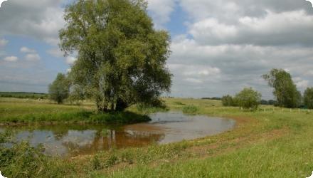
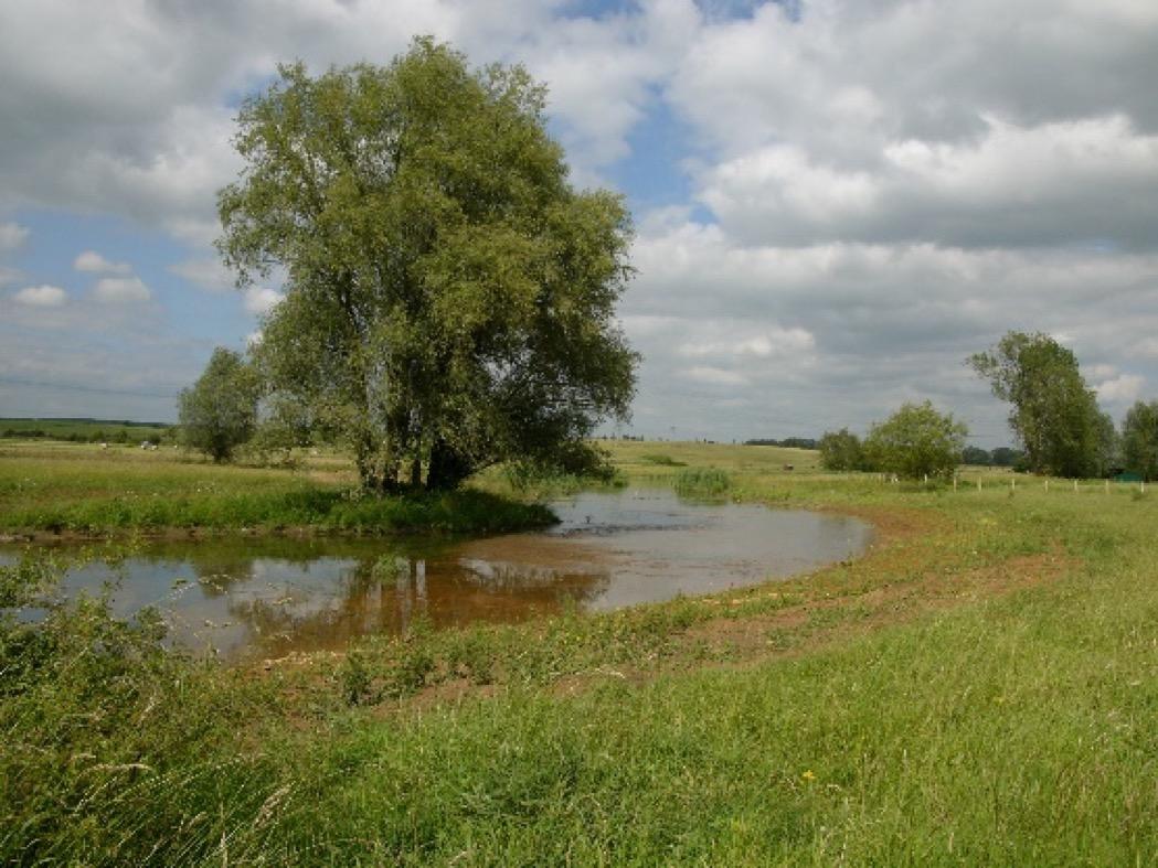
In the 1950s–60s, the Alzette floodplain was straightened for intensive agriculture, reducing water retention and ecological value. At Dumontshaff (Schifflange), the project set out to restore river-floodplain functioning (frequent overbanking, wetland habitat recovery) and to shift meadows to extensive management (late mowing, no fertiliser or biocides). After feasibility and land reallocation, works returned the river to its natural thalweg, widened and raised the bed, reactivated a secondary arm, and enabled floodplain and wetland restoration.
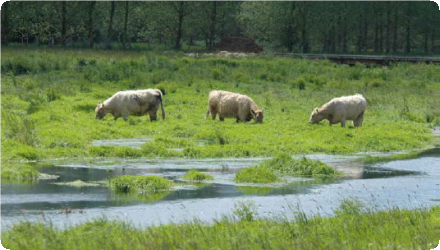
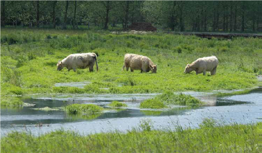
The main works on the Dumontshaff–Lameschmillen reach were completed in 2005 within a ~1.4 km section of the Alzette (plus ~600 m of the Kiemelbaach), with thalweg relocation and bed re-profiling; a dedicated project page reports a cost of ~€920k (excl. VAT). The wetland was formally designated as a National Nature Reserve in May 2023. Management now relies on year-round extensive grazing by Galloway cattle and water buffalo over >40 ha, and a nature trail (~4.4 km, 24 stations, observation tower) supports public access. Ecological outcomes include the return of Greater Spearwort (Ranunculus lingua) in 2009 and regular breeding of White Stork in the restored valley. Nearby, further renaturation on the Kiemelbaach was undertaken in 2020, while broader Alzette restoration continues upstream in separate projects.
The main works on the Dumontshaff–Lameschmillen reach were completed in 2005 within a ~1.4 km section of the Alzette (plus ~600 m of the Kiemelbaach), with thalweg relocation and bed re-profiling; a dedicated project page reports a cost of ~€920k (excl. VAT). The wetland was formally designated as a National Nature Reserve in May 2023. Management now relies on year-round extensive grazing by Galloway cattle and water buffalo over >40 ha, and a nature trail (~4.4 km, 24 stations, observation tower) supports public access. Ecological outcomes include the return of Greater Spearwort (Ranunculus lingua) in 2009 and regular breeding of White Stork in the restored valley. Nearby, further renaturation on the Kiemelbaach was undertaken in 2020, while broader Alzette restoration continues upstream in separate projects.
Position
Latitude
49.5057481
Longitude
6.0142918
Project
NWRM
National Id
Luxembourg_01
Installation date
1999
Implementation Status
Contact
Alexandra Rossi, ACTeon
RBD code
LU RB_000
Transboundary
0
Photo gallery
Location of the project
North of Schifflange, along the Alzette floodplain between Chemin de Bergem and Lameschmillen, near the A4 and Rue Denis Netgen; trailhead at Chemin de Bergem (L-4149).
NUTS Code
LU00 - Luxembourg
Project's objectives
Restore frequent floodplain connectivity and wetland habitats; shift channel to thalweg, widen bed, reactivate side arm; manage meadows extensively; increase storage & slow peaks (e.g., +20,000 m³; −30 cm at Am Brill), lengthen river corridor (+140 m).
Involved Partners
| Authority type | Authority name | Role | Comments |
|---|---|---|---|
Climate zone
cool temperate moist
Temperature
9
Precipitation
853
Annual rainfall range
600 - 900 mm
Elevation range
292 m
Vegetation class
Wetland herbaceous communities dominate: reedbeds (Phragmites roselières), tall-sedge meadows (magnocariçaies/cariçaies), wet Calthion meadows, eutrophic still waters and floodplain channels; with patches of alluvial/riparian woodland. The Natura 2000 habitat set includes 3150 (eutrophic lakes), 3260 (running waters with Ranunculion fluitantis), 6430 (tall-herb fringes) among others.
Water bodies: Ecological Status
Bad
Water bodies: Chemical Status
Failing to achieve good
Water quality status
Elevated nutrients and oxygen stress near Schifflange WWTP: ortho-P ~0.20 mg/L vs 0.07 good-status threshold; low O₂ saturation episodes; plus occasional accidental pollution events (2024).
Project scale
Meso
Project scale specification
It addresses a river reach and floodplain (Alzette + Kiemelbaach) across multiple communes, shifting planform, reactivating side arms and managing ~100+ ha of floodplain grasslands: beyond a single micro-site but not a whole basin.
Performance timescale
< 1 year
Project area
40
Area specifications
The area of the project is approximately 40 ha. The biodiversity is affected by the project in the area itself. Concerning the flood risk, it is reduced downstream, about 2 km away from the area.
Area subject to Land use change or Management/Practice change (ha)
10
Lifespan
The river restoration is expecting to stay several decades and even more.
The project was designed to restore the natural functions of the river and of its flood plain. Works were designed on this principle. Another important target was the management of the area after the project. This involved extensive agriculture and extensive grazing. The overall land planning led to enrich the landscape and its aesthetic value.
The project was designed to restore a natural wetland area. The dimensions were based on the original area. This information comes from old micording wetlands, swamps and bogs.litary maps re
Land was owned by farmers. The possibility to proceed to land exchange was a good opportunity; otherwise farming activities would have been a big constraint.
Costs total information
No information available
Costs investment information
No information available
Costs capital
€ 920,000
Costs operation maintenance information
No information available
Financing authorities
Type of funding
EU-funds: LIFE+
Comments
“Ecological valorisation of the Alzette’s upper valley” received LIFE co-funding (project LIFE99-NAT/L/006284; local NGO natur&ëmwelt coordinated).
Policy context
In the 50s and the 60s, the alluvial plain of the Alzette river was deeply modified. The river was channelized, the valley bottom was drained and dried, intensive agriculture had been developed. As a consequence, this land planning increased flood risk downstream and had a significant impact on biodiversity and landscape.
Land ownership
Mixed: c.61% private, 17% Commune(s) (Schifflange/Mondercange/Bettembourg), 17% State, 0.4% inter-municipal syndicates, 4% natur&ëmwelt – Fondation Hëllef fir d’Natur.
Community involvment
No
Design consultation activity
| Activity stage | Name | Key issues | Comments |
|---|
Policy target
| Target purpose |
|---|
|
Runoff control
|
|
Peak-flow reduction
|
|
Erosion Control
|
|
Improved Biodiversity
|
Target Remarks
Even if the flood risk mitigation was not the main project of the project, it had a real impact on it. Indeed, due to the large area concerned by the project, the impact on water retention and flood mitigation was relay important. Although, as it was not the main objective, the impact downstream was not assessed.
Policy pressure
| Pressure directive | Relevant pressure |
|---|---|
|
WFD identified pressure
|
Physical alteration of channel/bed/riparian area/shore of water body for agriculture
|
|
Floods Directive identified pressure
|
Other pressure contributing to flooding /flood risk
|
Policy impact
| Impact directive | Relevant impact |
|---|---|
|
Floods Directive identified impact
|
Protected areas
|
|
Floods Directive identified impact
|
Landscape
|
|
Floods Directive identified impact
|
Rural Land Use
|
|
WFD identified impact
|
Altered habitats due to morphological changes
|
Requirement directive
| Requirement directive | Specification |
|---|---|
|
Other EU
|
Habitat directive 92/43/EEC
|
|
WFD-achieving objectives for Protected areas
|
A bird protection area was implemented
|
|
WFD-mitigation of significant pressure
|
Restoration of the water course itself
|
Policy challenges requirements
The project targets are in line with the Luxembourg legislation. Thus, the law published the 19th January 2004 about nature protection provides conservation and restoration of ecological values.
Contractual arrangements
0
| Arrangement type | Responsibility | Role | Name | Comments |
|---|
Part of wider plan
0
Wider plan type
| Wider plan type | Wider plan focus | Name | Comments |
|---|
A biological monitoring is realized. Animal and plant species are observed and counted.
The main benefit is due to biodiversity improvement.
The wetland rehabilitation led to reduce flood risks downstream. The wetland also has a water purification function.
Information on retained water
Flood storage & attenuation: at the adjacent Am Brill reach, ~20,000 m³ added storage and ~30 cm reduction in high-water level; Dumontshaff reach: floodplain reconnection & reactivated secondary channel (qualitative gain).
Information on runoff reduction
Wetland functions of the area were restored. The flood plain is filled by rain falls and then restitutes water. As a consequence, the project led to a reduction in runoff. However, this effect has not been quantified.
Information on Peak flow rate reduction
The rainwater storage in the wetland shifts the peak flow and reduces it thanks to the overall vegetation and natural pounds. However, this effect has not been quantified.
Information on Reducing flood risks, quantity
Due to the peak flow shift and reduction, the project contributes to reduce flood risks. As it was an environmental project, this was not assessed.
Information on Water quality overall improvements
Wetlands have self purifying capacities. In contrast to channeled rivers, wetlands and pounds increase oxygen exchange. This oxygen allows the development of activities of micro-organisms which degrade organic matter. Wetlands are also a place of sedimentation.
Information on Soil quality overall soil improvements
N/A
1
The extensive grazing and the restoration of the river and of wetlands were beneficial for water quality and for the development of biodiversity (insects, birds, bats, etc.).
Ecosystem impact climate regulation
Increased permanent biomas
Ecosystem provisioning services
1
Information on Ecosystem provisioning services
The development of a didactic path is beneficial for local citizens and tourists who can walk in the area an learn about its management.
Key lessons
The Alzette restoration led to the development of extensive agriculture. The river restoration has many benefits for biological diversity and landscape beauty. It can be economically rewarding by changing the type of land-use and socio-economic settings. Although the main objective was to improve the ecological state of the area, the project has big impact on flood prevention and flood mitigation. The hydraulic effects (flood protection) and public awar ness rising are essential to increase public acceptance for such projects. Its success lead to further renaturation for the river, for example in the city Steinsel (Alzette and its tributary river Pétrusse) in 2023.
Success factor(s)
| Success factor type | Success factor role | Comments | Order |
|---|
Driver
| Driver type | Driver role | Comments | Order |
|---|
Transferability
Approach is transferable to straightened lowland rivers with available floodplain space. Critical enablers: land tenure/multi-owner agreements, room for lateral migration, and nutrient-source control upstream. National guidance stresses integrating hydraulic, habitat and water-quality goals and designing for frequent floods, not just rare extremes
Source(s)
English