Last update
2025
Summary
Water retention spaces, reforestation and grazing management in southern Portugal.
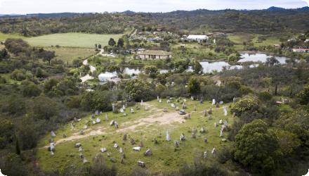
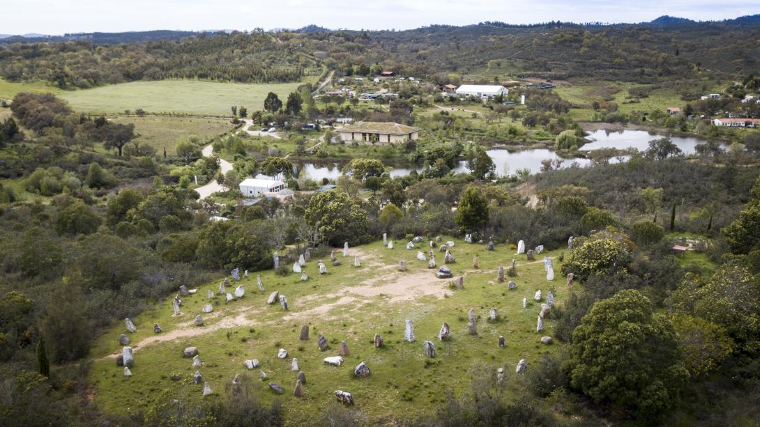
At Tamera (Monte do Cerro, Odemira), an ecovillage of 190 permanent residents and >100 non-permanent inhabitants, a “Water Retention Landscape” has been implemented since 2006 using reforestation and mixed groundcover, holistic grazing, keyline design, terracing, swales, and decentralized lakes and ponds. By 2015, 29 lakes/retention spaces expanded open water from 0.62 ha to ~8.3 ha across a 154–156 ha property; subsequent work shifted to infiltration, mulching, vegetation and dam maintenance. Reported outcomes include autonomous water supply, stabilization of groundwater levels and increased biodiversity; the lakes also supported neighbours and firefighters in drought and fire periods. A cost–benefit assessment for 2015–2050 was carried out (NPV sensitive to assumptions). Water-quality monitoring (2012–2014) found several lakes eutrophic, while distributed water met EU thresholds, underscoring the need for continued management. Legally, the site has been framed within a Rural Intervention Plan (PIER) for Monte do Cerro and Vale da Mua (156.35 ha), with public participation opened in 2015 and the process entering a decisive phase in 2023.
At Tamera (Monte do Cerro, Odemira), an ecovillage of 190 permanent residents and >100 non-permanent inhabitants, a “Water Retention Landscape” has been implemented since 2006 using reforestation and mixed groundcover, holistic grazing, keyline design, terracing, swales, and decentralized lakes and ponds. By 2015, 29 lakes/retention spaces expanded open water from 0.62 ha to ~8.3 ha across a 154–156 ha property; subsequent work shifted to infiltration, mulching, vegetation and dam maintenance. Reported outcomes include autonomous water supply, stabilization of groundwater levels and increased biodiversity; the lakes also supported neighbours and firefighters in drought and fire periods. A cost–benefit assessment for 2015–2050 was carried out (NPV sensitive to assumptions). Water-quality monitoring (2012–2014) found several lakes eutrophic, while distributed water met EU thresholds, underscoring the need for continued management. Legally, the site has been framed within a Rural Intervention Plan (PIER) for Monte do Cerro and Vale da Mua (156.35 ha), with public participation opened in 2015 and the process entering a decisive phase in 2023.
Position
Latitude
37.715
Longitude
-8.51583333333
Project
NWRM
National Id
Portugal_02
Installation date
2007
Implementation Status
RBD code
PTRH6
Transboundary
0
Photo gallery
Location of the project
Monte do Cerro, parish of Relíquias (Odemira, Beja). Access is off the IC1 between Ourique and Odemira: at the traffic lights in Relíquias turn right, then left toward São Luís; after ~500 m a small “Monte do Cerro” sign marks a dirt road (~4 km). GPS: 37°43’08.0″N, 8°31’14.1″W.
NUTS Code
PT18 - Alentejo
Project's objectives
Counteract land degradation and drought risk: reverse trends of erosion, desertification and droughts, and thereby reduce vulnerability to droughts, water scarcity and floods; become self-sufficient in water and food; showcase a replicable model for Mediterranean drylands.
Hydrological aim: retain all rainfall on site. Design a Water Retention Landscape with no rainwater run-off, so rainfall is absorbed by vegetation and water bodies and recharges groundwater. (Goal explicitly framed as “no runoff.”)
Quantified early targets (project statements, 2012): retain all rainwater, reduce soil erosion to near zero, replenish groundwater and encourage springs to reappear; supply food for a community of ~300 people; at that time 5 lakes were built and 10 more were planned.
Production/ecosystem objectives (planning documents): increase agricultural and forestry production by creating water-retention areas, mixed-culture biotopes and mixed reforestation, and build a regionally self-sufficient community (water, energy, food).
Involved Partners
| Authority type | Authority name | Role | Comments |
|---|---|---|---|
Climate zone
warm temperate dry
Temperature
16.5 °C
Precipitation
516
Annual rainfall range
300 - 600 mm
Runoff
250
Runoff range
450 - 600 mm
Evapotranspiration
159 m
Slope range
quite steep
Vegetation class
Mixed Mediterranean woodland and grassland/pasture mosaic, with olive groves and reforestation; riparian/shoreline plantings (e.g., alder, ash, elder; cork oak and other native trees away from water).
Water bodies: Ecological Status
Unknown
Water bodies: Chemical Status
Unknown
Water quality status
Several lakes were eutrophic during monitoring (2012–2014).
Project scale
Micro
Project scale specification
A site-specific intervention on a single property/valley (~154–156 ha), with multiple small retention structures and land-use measures; not a sub-basin or regional programme.
Performance timescale
1 - 4 years
Project area
133
Area subject to Land use change or Management/Practice change (ha)
133
Contruction water retention spaces: favorable site conditions (geology, soil permeability, topography, catchment annual runoff…)
Total cost
over € 500,000
Costs total information
Only for the creation of the water retentation lakes: more than 500,000€ (Source: Pijnappels and Dietl, 2013)
Financing authorities
Type of funding
Other
Comments
Activities are financed through donations and grants, by guests and the revenue from seminars, and from the Book Shop. The purchase of Tamera’s land and the initial investment were partially finance with loans
Compensations
0
Policy context
The ecovillage of Tamera (“Tamera Healing Biotope 1”), founded in 1995, is a community of 190 permanent residents (and 120 non-permanent inhabitants in 2012) living in a property of 133 ha located in the South of Portugal (Monte do Cerro, municipality of Odemira).
Main problems affecting the area where Tamera is located are: deteriorated soils (washed fertile topsoil layers, damaged structure, erosion and desertification) due to pressures put in the past (such overgrazing and unsuitable agricultural practices) and water quantity issues (heavy rainfalls causing flooding and, on the other side, water scarcity and droughts). The application designed and implemented consists of the creation of “Water Retention Landscapes” (i.e. “systems for the restoration of the full water cycle by retaining the water in the areas where it falls as rain” -Ulbig, 2014-) covering 5 areas (water, forest, gardens, seeds and pasture management).
Measures implemented were: reforestation and the planting of mixed-culture ground cover vegetation; holistic grazing management; keyline design; terracing; swales; and the mos well-know measure, the construction of water retention spaces in the form of decentralized lakes and ponds (interconnected permanent artificial lakes and ponds designed to retaining rainwater not sealed with concrete/plastic material and with a natural material dam with slope 1:2 as a barrier).
Land ownership
The land and infrastructure are owned by ILOS – Peace Research Center, Lda. ILOS is equally owned by the associations G.R.A.C.E. and AMH (communautarian ownership).
Community involvment
No
Design consultation activity
| Activity stage | Name | Key issues | Comments |
|---|
Policy target
| Target purpose |
|---|
|
Increase Water Storage
|
|
Runoff control
|
|
Groundwater Recharge
|
|
Improved Biodiversity
|
|
Oher Societal Benefits
|
Policy pressure
| Pressure directive | Relevant pressure |
|---|
Policy impact
| Impact directive | Relevant impact |
|---|
Requirement directive
| Requirement directive | Specification |
|---|
Contractual arrangements
0
| Arrangement type | Responsibility | Role | Name | Comments |
|---|
Part of wider plan
0
Wider plan type
| Wider plan type | Wider plan focus | Name | Comments |
|---|
Studies recommend seasonal, long-term monitoring of lake water quality, wastewater nutrient loads, groundwater tables, lake levels and precipitation/ET to quantify recharge and manage eutrophication risks.
Measured parameters include in-situ temperature, pH, conductivity, dissolved oxygen, depth profiles; ions/nutrients (e.g., nitrate, phosphate, potassium, chloride); stable isotopes (δ¹⁸O, δ²H) to trace groundwater–lake interactions; groundwater tables (over a year); drinking-water ions (taps/tanks) and wastewater nutrient loads across septic tank and 200 m² reed-bed; plus rain–runoff series from temporary runoff gauges and basic lake-system simulations. Recommended additions include continuous data-logging of lake levels/discharges and accounting for evapotranspiration in future analyses.
Maintenance
Ongoing management focuses on dam inspection/repair, mulching and vegetation works to sustain infiltration and fire-resilience.
Catchment outlet
The inhabitants themselves (and specially, the Ecology Department of the community under the form of a specific association -AMH-) are in charge of the assesing the degree of compliance with the objectives with the support of external experts (such as the Permaculture specialist Sepp Holzer, or from several universities)
Slow rainwater runoff
Enhance biodiversity (habitat and biodiversity conservation)
Increasing water storage capacity (recover the groundwater table)
Agricultural productivity increase (local food production autonomy and effects in terms of economic growth in the community)
Reduced irrigation needs (soils wetter; aquifers filled), and reduced vulnerability to drought/heat via stored water and diversified vegetation.
Social benefits as recreational services and amenity and clean water for different uses (for drinking and for irrigation).
Ecosystem functions that provide co-benefits as in the case of storing and fixing carbon and serving as wildlife habitats and ecological corridors.
Increasing water storage capacity reduce dowstream flooding events.
Contributes to prevent rural depopulation.
Contributes to control desertification process in the area
Contributes to the development of a alternate model
Information on retained water
Retention & hydraulic system. From 2006–2015, 29 lakes/retention spaces were built; open-water area increased from 0.62 ha → ~8.32 ha. The highest lake enables gravity-fed irrigation; the site is now “prepared to fully absorb even strong continuous rainfall.” A new perennial spring appeared after Lake 1; lakes help neighbours and firefighters in drought/fire periods.
Reported stabilization of the groundwater table; since 2011 drinking water is supplied from wells fed by the WRL (bank filtration). Isotope/hydrochemistry evidence shows lakes contribute to aquifer recharge, though long-term rates weren’t quantified.
Reported stabilization of the groundwater table; since 2011 drinking water is supplied from wells fed by the WRL (bank filtration). Isotope/hydrochemistry evidence shows lakes contribute to aquifer recharge, though long-term rates weren’t quantified.
Information on increased water storage
By means of the construction of water retention spaces (lakes and ponds) water storage capacity is enhanced.
Information on Ecosystem water supply
Since 2011 drinking water needs of the community of are supplied from wells fed by the Water Retention Landscape (190 permanent residents and 120 non-permanent inhabitants in 2012.
Ecosystem erosion control
1
Information on Ecosystem erosion control
Due to the implemented refforestation measures
Water quality overall improvements
Positive impact-WQ improvement
Information on Water quality overall improvements
Design principles applied to the water retention spaces contribute to improve water quality (winding banks, different bed depths…) by enhancing self-purification processes.
Several lakes were in eutrophic state during 2012–2014 monitoring. Depth-profile examples include total phosphate up to ~2.9 mg/L (Nov) in one lake; nitrate generally ≤ ~2.5 mg/L. The 200 m² reed bed’s phosphorus outputs exceeded EU limits in both monitored months; recommendation to upgrade capacity and monitor nutrient outflows. Elevated ions/conductivity in some lakes/wells could increase soil/groundwater salinity if used for irrigation ; flagged as a risk to manage.
Several lakes were in eutrophic state during 2012–2014 monitoring. Depth-profile examples include total phosphate up to ~2.9 mg/L (Nov) in one lake; nitrate generally ≤ ~2.5 mg/L. The 200 m² reed bed’s phosphorus outputs exceeded EU limits in both monitored months; recommendation to upgrade capacity and monitor nutrient outflows. Elevated ions/conductivity in some lakes/wells could increase soil/groundwater salinity if used for irrigation ; flagged as a risk to manage.
Soil quality overall soil improvements
Positive impact-SQ improvement
Information on Soil quality overall soil improvements
By means of topsoil creation, soil quality is enhanced in general terms.
1
More than 10.000 planted trees: areas afforested with a wide diversity of species and fruit tree plantations. WRL created riparian and woodland habitats; plantings include alder, ash, elder near water and olive/cork oak elsewhere. Forest corridors are useful as protected paths for wild animals (e.g. boars, badgers, foxes, genets and forest owl) to reach the lakes and ponds.
Ecosystem impact climate regulation
Impact on GHGs (net emissions and storage) including soil carbon
Information on Ecosystem impact climate regulation
Increase CO2 stored due to the forest and soil restauration measures
Information on Ecosystem impact other GHG
Quantified land-cover change & carbon link. Transitional woodlands increased from 9.34 ha to 19.50 ha (2006–2014), supporting a ~9.4%/year increase in carbon storage over that period.
Information on Ecosystem provisioning services
Contribution to the regional food autonomy (objective of the project: 80% regional food autonomy) as progressively more vegetables and fruits consumed by the community are grown in their own gardens, on the terraces and at the shores of the water retention spaces.
Key lessons
Recognition and replicability. The Water Retention Landscape (WRL) at Tamera gained international visibility, selected as a finalist for the 2012 Buckminster Fuller Challenge, and has been analysed in EU programmes (CIRCLE-2 and BASE). This visibility underscores its perceived replicability for Mediterranean drylands and beyond, particularly the use of decentralized lakes/ponds integrated with land management.
Design + community capacity are pivotal. Two success factors recur: access to specialized design knowledge to adapt structures to local climate/topography, and the ability to convince and mobilize a community to sustain a multi-functional investment over years.
Navigate regulation early and precisely. Legal framing mattered: explicitly defining the features as “water retention spaces” rather than lakes helped fit the works into the regulatory landscape; conversely, complex legal procedures were a limiting factor.
Adapt over time: from construction to care. After 2015 the emphasis shifted from creating open-water bodies to infiltration support, vegetation/mulch works, dam checks and amid stricter fire-prevention rules landscape practices that keep soils humid and reduce fire risk. Long-term performance depends on this maintenance.
Monitor benefits and risks, not just structures. Documented positives include stabilising groundwater and even the emergence of a new perennial spring; however, several lakes showed eutrophic conditions and the reed-bed system’s phosphorus outflows exceeded limits at times. The thesis recommends seasonal, long-term monitoring of lake water quality, groundwater tables/recharge, precipitation and wastewater loads.
Economics are assumption-sensitive and co-benefits matter. A cost-benefit analysis for 2015–2050 yielded a negative NPV at 3%, yet identified tangible co-benefits (visitor income, land-value uplift, biodiversity and agricultural gains) and noted many unquantified benefits that could change results under different assumptions.
Social spillovers build legitimacy. Cooperation with neighbours and support to firefighters in drought/fire periods, plus ongoing education and training, strengthened the project’s social value and diffusion potential.
Overall lesson. WRLs can restore local hydrology and resilience at site scale, but long-term success hinges on governance (legal fit and financing), adaptive maintenance, and robust monitoring to manage water-quality risks while capturing broad co-benefits.
Success factor(s)
| Success factor type | Success factor role | Comments | Order |
|---|---|---|---|
|
Specific incentives for stakeholder involvement
|
main factor
|
1
|
|
|
Public participation
|
secondary factor
|
<p>About to sign a contract between Tamera and the Municipality</p>
|
2
|
Driver
| Driver type | Driver role | Comments | Order |
|---|---|---|---|
|
Organisation committed to it
|
main driver
|
Strong commitment with “changing” subsistence and regional autonomy, in regard to infrastructure, new forms of water management and cooperation with nature
|
1
|
Transferability
Transferable as a site-scale WRL for Mediterranean/dry climates, if adapted to local topography, soils and hydrogeology. Success needs clear permitting and financing, skilled design, and community capacity. Watch for eutrophication and wastewater nutrient loads, dam safety, possible salinization, and ensure long-term maintenance and monitoring (groundwater, water quality, lake levels).
English