Last update
2025
Summary
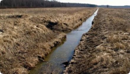
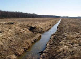
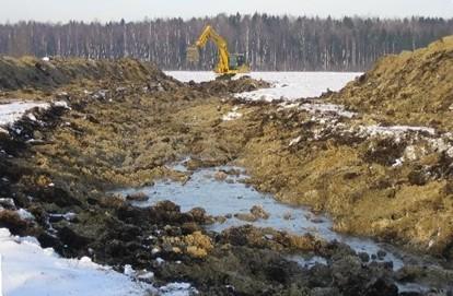
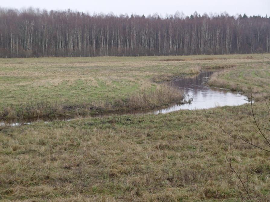
The floodplain restoration of the River Slampe was carried out in 2005 within the Kemeri National Park, Latvia. The aim of the measure was to re-establish the natural floodplain regime of the Dunduri meadows by reconnecting them to the hydrological cycle of the river Slampe, which had been previously channelised. The restoration involved closing the outlet of the straightened riverbed, reconstructing approximately 2.1 km of the riverbed in a new meandering course of 4.65 km, and constructing a small dam at the downstream end near the Slampe-Kauguri canal. This raised the water level by about one metre, allowing for natural flooding of about 105 ha of floodplain meadows during seasonal high flows.
The project significantly improved floodplain hydrology and restored natural habitats. In the short term, early ecological results included sedimentation, island formation, and recolonisation by aquatic species. The reconnection of the river and floodplain also contributed to rewetting of previously drained meadows. However, monitoring two to three years after implementation indicated that ecological water quality had not improved significantly. The absence of riparian vegetation and high nutrient inflow from surrounding agricultural lands limited progress towards good ecological status. Dominance of filamentous green algae (Cladophora glomerata) was noted.
As of recent assessments (2021–2023), the Slampe River is still classified as a heavily modified water body, with potential to reach good ecological status depending on further catchment-wide measures. Long-term maintenance and monitoring have continued under post-LIFE frameworks, although no major restoration works have been added since. The site remains under active conservation within the Kemeri National Park.
Overall, the restoration successfully achieved hydrological and habitat objectives, but further actions may be required to improve water quality and riparian structure.
Position
Latitude
56.8299499
Longitude
23.4008938
Project
NWRM
National Id
Latvia_01
Installation date
2005
Contact
Ilze Kalvane, BEF Latvia
RBD code
LVLUBA
Transboundary
0
Photo gallery

Location of the project
Along the river Slampe
NUTS Code
LV00 - Latvija
Project's objectives
Reconnect floodplain meadows: Restore natural flooding to approx. 105 ha of Dunduri meadows in Kemeri National Park.
Reconstruct river course: Replace a straightened 2.08 km section with a new 4.65 km meandering channel.
Raise water levels: Build a small dam to raise water level by ~1 meter, enabling seasonal overflows.
Enhance habitats: Create diverse in-stream structures (islands, riffles, pools) to support biodiversity recovery.
Support birdlife: Improve conditions for migratory waterbirds (e.g., swans, herons, ospreys) through wetland expansion.
Excavation volume: Approx. 23,880 m³ of soil removed to shape the new riverbed.
Involved Partners
| Authority type | Authority name | Role | Comments |
|---|---|---|---|
Climate zone
cool temperate moist
Temperature
6
Precipitation
650
Annual rainfall range
600 - 900 mm
Runoff coefficient range
0.2 - 0.3
Runoff range
150 - 300 mm
Imperviousness range
20 - 40%
Elevation range
8
Vegetation class
The area is predominantly covered by grass- and tall-herb turf, dominated by nitrophilous species such as Dactylis glomerata, Calamagrostis epigejos, and Artemisia vulgaris. Wet depressions host reed and reed canary grass. Vegetation reflects early successional, nutrient-rich floodplain meadows.
Water bodies: Ecological Status
Moderate
Water bodies: Chemical Status
Failing to achieve good
Water quality status
Water quality status according to benthic macroinvertebrates was assed as moderate in 1998. Concentrations of nutrients (N and P) were significantly increased in some measurements. Assessed aquatic vegetation showed richness of the nutrients in the water.
Project scale
Micro
Project scale specification
2.1 km long stretch of the channeled river was turned in to 4.6 km long meandered stream. Natural floodplain grasslands resorted in 105 ha
Performance timescale
1 - 4 years
Project area
105 ha
Area subject to Land use change or Management/Practice change (ha)
105
Size
4,59999990463257
Size unit
km
- to restore hydrological regime characteristic to floodplain in surrounding meadows;
- costs;
- existing relief.
- costs;
- existing relief.
Design capacity description
2.1 km long stretch of the channelled river was turned in to 4.6 km long meandered stream. Floodplain meadows restored in 105 ha
Lack of experience and knowledge of all stakeholders, acceptance of the neighbouring landowners.
Measures implemented in protected area and the landowner is the state
Total cost
€ 144,547.81
Costs total information
144 547.81 € Without administrative and personnel costs
32 597,15 € Technical project and implementation
111 950,66 € In total 163,2 ha purchased land
32 597,15 € Technical project and implementation
111 950,66 € In total 163,2 ha purchased land
Costs operation maintenance information
It is not calculated, but there is only visual monitoring carried out by inspectors of Ķemeri national park.
Financing authorities
Type of funding
EU-funds: LIFE+
Comments
EC LIFE Nature programme
Type of funding
National funds
Comments
Latvian Environmental Protection Fund
Compensations
0
Policy context
In order to make Dunduru meadows more suitable for agriculture, the course of River Slampe was straighten in 1970. Since 1997 Dunduru meadows are included in newly established Ķemeri National park. Maintenance and restoration of the natural assets are the main goals for the park and restoration of the Dunduru meadows helped to restore natural floodplain grasslands ensuring suitable habitat for several species of EU and Latvian importance.
Land ownership
State of Latvia
Community involvment
No
Design consultation activity
| Activity stage | Name | Key issues | Comments |
|---|
Policy target
| Target purpose |
|---|
|
Improved Biodiversity
|
|
Groundwater Recharge
|
Target Remarks
Restoration of floodplain hydrological regime in Dunduru meadows
Policy pressure
| Pressure directive | Relevant pressure |
|---|
Policy impact
| Impact directive | Relevant impact |
|---|---|
|
WFD identified impact
|
Altered habitats due to hydrological changes
|
|
Other EU
|
HBD – Habitat and Bird directive
|
Requirement directive
| Requirement directive | Specification |
|---|
Contractual arrangements
0
| Arrangement type | Responsibility | Role | Name | Comments |
|---|
Part of wider plan
0
Wider plan type
| Wider plan type | Wider plan focus | Name | Comments |
|---|
Monitoring of the groundwater level was planned to be carried out in 13 boreholes at the river Slampe once in a month, but due to financial constraints the water level records are taken very seldom.
Level of the groundwater
Maintenance
Controlling the condition of the dam before estuary of the River Slampe. Responsible authority is the Ķemeri National Park.
Edge of Field/Plot
Monitoring of the groundwater level was planned to be carried out in 13 boreholes at the river Slampe once in a month, but due to financial constraints the water level records are taken very seldom.
The assessment of the ecological status is defined in the national legislation based on the WFD requirements.
Fish and plants, tourism, recreation, and others
Information on retained water
Water retention is increased. The measure ensured that territories are flooded during the spring : 150 ha of restored floodplain meadows. 30 % of restored meadows were flooded by first spring floods, but flooded area depends from the floods volume. The restoration raised mean water levels in the downstream Skudrupīte floodplain by approximately 0.45-0.9 m, enhancing seasonal inundation dynamics.
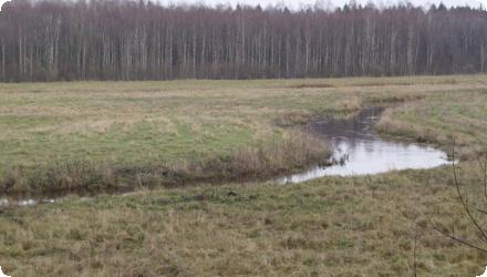
Remeandering work created diversified structure : introduction of meanders, islets, various channels.
Remeandering work created diversified structure : introduction of meanders, islets, various channels.
Water quality overall improvements
Neutral impact-no change in WQ status
Information on Water quality overall improvements
Water quality according to water biological quality elements (macroinvertebrates and aquatic macrophytes) are not increased. Early monitoring (2–3 years post-restoration) noted persistent high nutrient input, dominance of Cladophora glomerata, and limited improvement of ecological water quality.
Soil quality overall soil improvements
N/A info
1
Restored floodplain meadows in 105 ha, which is important resting and feeding place for migratory water birds and re-meandered river is suitable feeding place for Ciconia nigra (bird species of EU importance). At the same time observed 4 individuals.
Ecosystem impact climate regulation
No information available
Ecosystem provisioning services
1
Key lessons
Expert on hydrology has to be involved in the development of the technical project.
Hydrological and water quality assessments have to be carried out prior to the re-meandring.
Restoring physical processes does not guarantee ecological quality. Despite restored flows, ecological water quality remained poor due to external nutrient inputs and absence of riparian vegetation. Catchment-wide nutrient management is essential to support in-stream ecological recovery.
Vegetation structure takes time to develop. Recolonisation occurred quickly, but vegetation remained dominated by early-successional, nitrophilous species, limiting biodiversity and filtration functions. Long-term management (e.g. grazing, mowing) is key to guiding vegetation succession toward target meadow communities.
Post-restoration monitoring is critical. The project included early monitoring, but lacked long-term, quantitative follow-up on biodiversity, water quality, or infiltration rates. Future projects should plan monitoring over at least 10–15 years, especially in slow-recovering ecosystems.
Restoration must be embedded in landscape-scale planning. Continued degradation from surrounding agricultural runoff limited water quality improvements. Successful restoration requires coordination with upstream land use practices (buffer zones, farming regulations, etc.).
Multipurpose land use (e.g. grazing) supports maintenance. The use of Konik horses and cattle helped manage vegetation cost-effectively, showing that agro-ecological approaches can maintain restored functions without intensive human input.
Success factor(s)
| Success factor type | Success factor role | Comments | Order |
|---|---|---|---|
|
Financing possibilities
|
main factor
|
<p>Availability of financial resources and financing potential to implement such measures.</p>
|
1
|
Driver
| Driver type | Driver role | Comments | Order |
|---|---|---|---|
|
Other
|
main driver
|
Availability of financial resources and financing potential to implement such measures.
|
1
|
Flexibility adaptability
Implemented project had numerous mistakes in technical project that have to be improved.
Transferability
Taking into account EU Policy goals on biodiversity to restore 15 % of depredated land up to 2020, goal of the WFD to reach good water quality, goals of the FD and local conditions, remeandering and floodplain restoration (for water retention and nutrients capture) is recommendable to implement in a slowly flowing streams within the agricultural lands.
English