Last update
2025
Summary
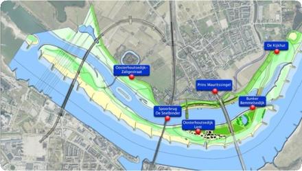
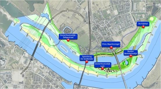
This flagship of the national Room for the River programme at Nijmegen set back the dyke at Lent and excavated the Spiegelwaal side channel, creating the Veur-Lent island and an urban river park that can take additional flood flow from the Waal. Completed in 2016, the scheme achieves about 35 cm lower design water levels—exceeding the original 27 cm target—and safely diverts high flows; the channel first overtopped its threshold in February 2016. Since delivery, the area has been reshaped as public space with new bridges and intense recreational use. In 2022 the city decided not to build housing on Veur-Lent, keeping the island largely as parkland (with limited facilities), while planning proceeds nearby. The Spiegelwaal now serves as a pilot in “Connected River” to balance flood safety, water quality and heavy leisure demand; bathing advice has at times been negative due to bacteriological risks. Funding came mainly from the State, with total costs reported at about €351 million.
Position
Latitude
51.856
Longitude
5.862
Project
NWRM
National Id
Netherlands_01
Installation date
2013-2016
Implementation Status
Contact
Heather Williams and Dilian Jansen, AMEC
RBD code
NLRN
Water body code
NLGW0003
Transboundary
0
Photo gallery
Location of the project
Near the town of Nijmegen, in eastern Netherlands
NUTS Code
NL22 - Gelderland
Project's objectives
Lower design high-water level by ~27 cm at Nijmegen for Q=16,000 m³/s; move the northern dike ~350 m inland; create an ancillary channel/urban river park. Result exceeded target with ~35 cm reduction post-completion (2016).
Involved Partners
| Authority type | Authority name | Role | Comments |
|---|---|---|---|
Climate zone
cool temperate moist
Temperature
10.8 °C
Annual rainfall range
600 - 900 mm
Elevation range
13 m
Slope range
0-1%
Vegetation class
Mosaic of riparian grasslands, reed and tall-herb fringes, and softwood riparian forests (“ooibos”), consistent with Natura 2000 “Rijntakken” targets; grazed floodplain nature nearby (Gelderse Poort/Stadswaard).
Water bodies: Ecological Status
Poor
Water bodies: Chemical Status
Failing to achieve good
Water quality status
Bathing water frequently constrained by bacteria and episodic cyanobacteria; urban/recreation pressures in a busy side channel.
Project scale
Meso
Project scale specification
Creates an entire new district of the city
Performance timescale
< 1 year
Project area
70
Area specifications
The 70 hectares only applies to the area where the dike will be moved back 350 meters.
Lifespan
Permanent when maintained
The main principles were increasing water safety (reduced risk of flooding) within an integrative planning framework. The measures are incorporated with an area of urban development that will provide aesthetic and recreational benefits, together with an enhancement of the spatial quality in the area.
Design capacity description
The design capacity is at such a level that the water level in the River Waal will locally be 35 centimeters lower during flooding events than without the measure (without adversely impacting upstream water capacity and with beneficial circumstances further downstream)
The main factor that influenced the choice for this measure was the possibility to combine it with a larger city redevelopment project. The creation of a district on the other shore of the Waal, together with a revitalization of the shore at the old city center made the creation of this river park that will be in the center of the city in the future possible.
This type of measure is suitable for rivers with permanent flow where the capacity to flow out-of-bank is currently restricted. There are no specific basin characteristics that are necessary, as the measures could be applied in a range of situations.
The availability of open space in between the current river bank and the town. The sharp meander in the river provided a suitable geometry for addition of this type of measure
Positive influence effectiveness
The availability of open space in between the current river bank and the town.
Negative influence effectiveness
It has to be closely monitored that no additional groundwater seepage will occur in the area around Lent (an area that already experience a lot of seepage)
Total cost
€351 million
Costs investment
€ 351,000,000
Costs investment information
Cost of the entire project, including the water retention mesures.
Financing authorities
Type of funding
National funds
Comments
as part of the Room for the Rivers program
Compensations
1
Compensations annual information
Compensation is required to owners and occupiers of the land that will be used for the measures, who will be displaced.
Policy context
Addressing the risk of flooding from the River Waal, particularly following flooding events in 1993 and 1995. This is part of a national programme of work by the national government to make 'Room for the River'.
Land ownership
Spiegelwaal water/bed: State (Rijkswaterstaat). Bridges: City of Nijmegen. Most grounds on the city island (Veur-Lent): City. Stadswaard floodplain east of town: largely Staatsbosbeheer.
Community involvment
Yes
Design consultation activity
| Activity stage | Name | Key issues | Comments |
|---|---|---|---|
|
Extensive public communication for the national programme as a whole, as well as locally for this specific measure
|
Policy target
| Target purpose |
|---|
|
Peak-flow reduction
|
|
Increase Water Storage
|
|
Oher Societal Benefits
|
Target Remarks
The water retention measure is being combined with a city development project.
Policy pressure
| Pressure directive | Relevant pressure |
|---|---|
|
WFD identified pressure
|
Physical alteration of channel/bed/riparia n area/shore of water body for flood protection
|
|
Floods Directive identified pressure
|
Blockage / Restriction
|
Pressures remarks
Currently a bottleneck exists in the sharp bend of the river, which will be remedied moving back the dyke and the digging of a parallel channel inside the reconnected floodplain.
Policy impact
| Impact directive | Relevant impact |
|---|---|
|
WFD identified impact
|
Altered habitats due to hydrological changes
|
|
Floods Directive identified impact
|
Rural land use
|
Impact remarks
Rural area in the area between the current dike and the town of Lent will be affected as the channel will be dug here and the area will be completely reformed, leaving no room for previous uses.
Requirement directive
| Requirement directive | Specification |
|---|---|
|
WFD-mitigation of significant pressure
|
Bottleneck at a location with high population density will be solved
|
|
WFD-achievement of good ecological status
|
On the new island there will be room for nature development
|
|
Floods Directive-mitigating Flood Risk
|
The measure will significantly reduce the flood risk
|
Policy challenges requirements
The Planologisch kernbesluit (PKB) Ruimte voor de Rivieren forms the overall impetus for this NWRM. The PKB identifies roles and responsibilities for 30 individual NWRM related projects to reduce flood risk of the entire river system.
Contractual arrangements
0
| Arrangement type | Responsibility | Role | Name | Comments |
|---|
Part of wider plan
1
Wider plan type
| Wider plan type | Wider plan focus | Name | Comments |
|---|---|---|---|
|
National
|
Water
|
Room for the River programme
|
National strategy to create more space for flooding, rather than raising dykes further, initiated following widespread flooding in 1993 and 1995
|
|
National
|
Water
|
FloodResilienCity (FRC)
|
INTERREG IVB programme enabling public authorities in eight cities in North West Europe to better cope with urban flooding. Nijmegen is one of the eight cities
|
Laboratory
Monitoring is carried out of river flows in the Waal. The measure has been modelled prior to implementation, consistently with all schemes in the Room for the River programme: this has allowed the performance of the whole Room for the River programme to be assessed, not only this individual scheme.
Flood risk reduction in the lower Waal
Amenities and social benefits relating to housing provision, recreation, greening cities : Creation of new permanent aquatic habitat. Urban development with a strong blue-green connection.
Information on retained water
Reduced extreme water levels by ≈35 cm; during high flows ~⅓ of discharge is routed via the Spiegelwaal; overtopping threshold provides controlled activation; creation of a new island and low-flow habitats altered local hydromorphology.
Information on Peak flow rate reduction
The measure provides a 35 cm reduction in design flood peak height on the River Waal.
Information on Increased groundwater level
Groundwater levels can already be high in this area, causing groundwater seepage. It was a specific aim of the project to ensure that groundwater seepage did not increase.
Information on Restoring hydraulic connections
Hydraulic connection between the river and part of its floodplain is being restored by moving the dyke backwards by 350m, and developing a new channel within the floodplain that will always contain water and will provide additional flood capacity.
Water quality overall improvements
Not relevant for this application
Soil quality overall soil improvements
Not relevant for this application
1
Provision of increased aquatic and riparian habitat along the edges of the new channel
Ecosystem impact climate regulation
No specific impact
Key lessons
The ability to have an influence at a large scale, particularly in the lower reaches of a major river basin, requires commitment at high levels of government. This is the case with the Room for the River programme.
The integration of this particular scheme in to a wider programme with an overall goal ensures that individual measures do not adversely affect flood vulnerability in down- or upstream locations or in other river basins, and that the combination of individual measures leads to a cumulative, quantifiable positive effect on flood risk.
The integration of this particular scheme in to a wider programme with an overall goal ensures that individual measures do not adversely affect flood vulnerability in down- or upstream locations or in other river basins, and that the combination of individual measures leads to a cumulative, quantifiable positive effect on flood risk.
Success factor(s)
| Success factor type | Success factor role | Comments | Order |
|---|---|---|---|
|
Attitude of decision makers
|
main factor
|
1
|
|
|
Financing possibilities
|
main factor
|
2
|
Driver
| Driver type | Driver role | Comments | Order |
|---|---|---|---|
|
Past flooding events
|
main driver
|
Flooding events in 1993 and 1995 led to the development of the national Room for the River programme
|
1
|
|
Organisation committed to it
|
main driver
|
The national government decided on this approach and has led and funded its implementation
|
2
|
Flexibility adaptability
The current NWRM did not only aim to meet current peak water levels historically measured, but the Ruimte voor de Rivieren program as a whole aims to be able to handle an increased flow rate to 16,000 m3/s (from 15,000 m3/s) (across the main distributaries of the Rhine); this in anticipation of future more extreme weather circumstances caused by climate change.
Transferability
The measure here is being applied to a large river near the bottom of a very large transboundary river basin. However similar measures could also be applied on a smaller scale.
In a water retention measure being combined with a city redevelopment project, it is important that there is an actual demographic/public demand to attract future private investment in the newly developed housing area and recreational activities.
In a water retention measure being combined with a city redevelopment project, it is important that there is an actual demographic/public demand to attract future private investment in the newly developed housing area and recreational activities.
Basin characteristics influence
This type of measure is suitable for rivers with permanent flow where the capacity to flow out-of-bank is currently restricted. There are no specific basin characteristics that are necessary, as the measures could be applied in a range of situations.
Cost effectiveness
A traditional approach may have been to increase the flood defenses of the existing channel of the Waal.
Source(s)
English