Last update
2025
Summary
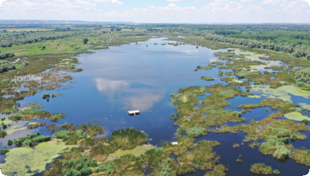
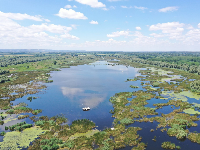
Restoration of two wetlands along the Danube River within Persina Nature Park, through engineering works including sluices, channels, dykes and access roads, enabling controlled flooding, water flow to former wetlands, nutrient retention, and recovery of biodiversity and fish populations. Baseline data on water, birds, fish, mammals, reptiles and vegetation were collected for monitoring.
Implemented 2002–2008 by the Bulgarian Ministry of Environment and Water, with main funding from the Global Environment Facility (GEF) via the World Bank, the project also covered the Kalimok-Brashlen and Belene Islands Complex. Works improved hydrological connectivity and reduced pollution, supported by WWF Bulgaria and local communities.
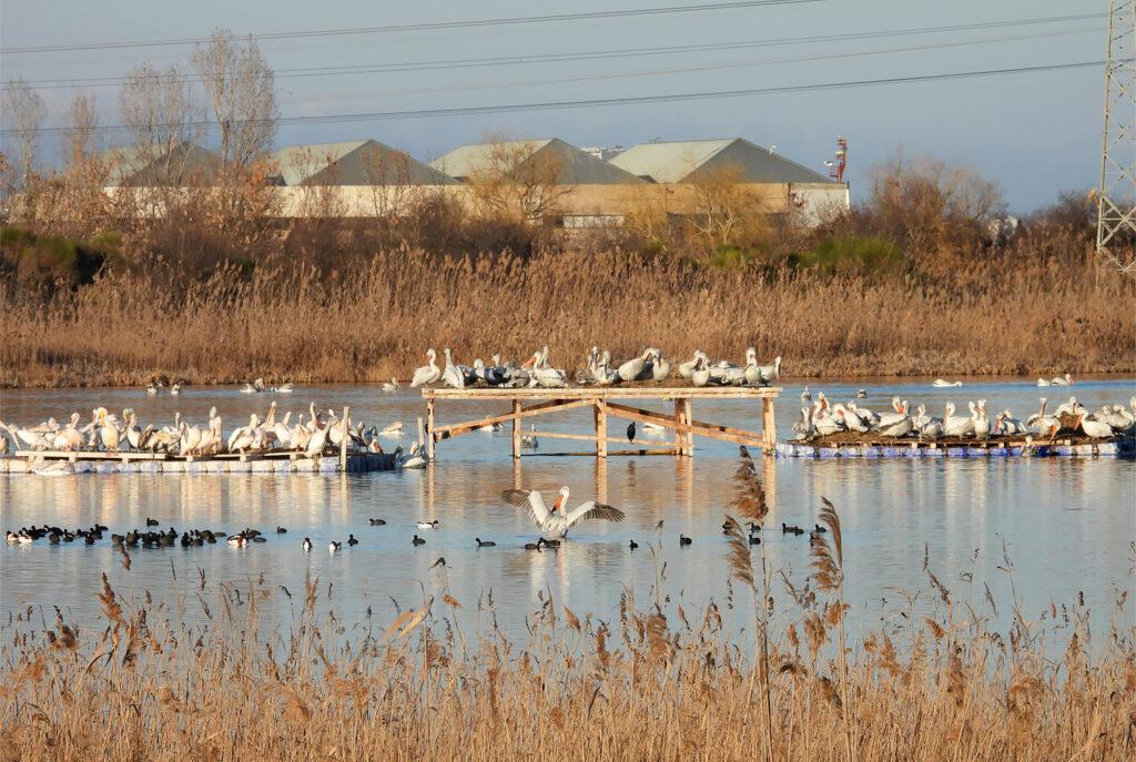
Subsequent initiatives have continued restoration and management, including sluice maintenance, construction of a pelican nesting platform, and reintroduction of the white water lily. In 2025, the Persina4Nature project, under the DANUBEPARKS network, was launched to promote citizen science for wetland conservation and monitoring, further enhancing ecological and community engagement outcomes.
Implemented 2002–2008 by the Bulgarian Ministry of Environment and Water, with main funding from the Global Environment Facility (GEF) via the World Bank, the project also covered the Kalimok-Brashlen and Belene Islands Complex. Works improved hydrological connectivity and reduced pollution, supported by WWF Bulgaria and local communities.
Subsequent initiatives have continued restoration and management, including sluice maintenance, construction of a pelican nesting platform, and reintroduction of the white water lily. In 2025, the Persina4Nature project, under the DANUBEPARKS network, was launched to promote citizen science for wetland conservation and monitoring, further enhancing ecological and community engagement outcomes.
Position
Latitude
43.88
Longitude
26.0
Project
NWRM
National Id
Bulgaria_01
Installation date
2007
Implementation Status
Contact
Jovanka Ignjatovic REC
RBD code
BG1000
Transboundary
0
Photo gallery
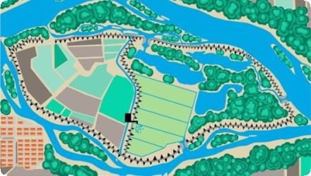
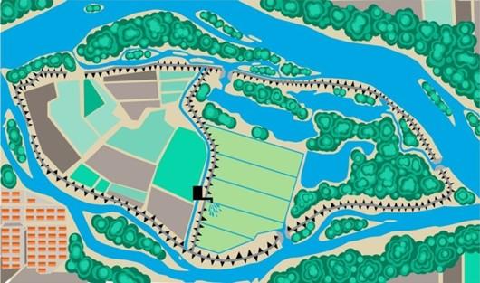
Location of the project
Belene Island (2 280 ha) within the Persina Nature Park and Kalimok/Brushlen (1 755 ha) within the Kalimok
NUTS Code
BG32 - Северен централен (Severen tsentralen)
Project's objectives
Project aim: “Create a model for reducing trans-boundary nutrient loads in the Danube and Black Sea basins and to preserve biodiversity in the protected sites through: restoration of wetlands, management plans for protected sites and support to the local people in adopting environmentally friendly economic activities.”
Involved Partners
| Authority type | Authority name | Role | Comments |
|---|---|---|---|
Climate zone
cool temperate dry
Temperature
11,7
Precipitation
540
Annual rainfall range
600 - 900 mm
Runoff
6000
Runoff coefficient
0,15
Runoff coefficient range
0 - 0.2
Runoff range
150 - 300 mm
Evapotranspiration
0,270000010728836
Imperviousness range
0 - 10%
Remarks runoff imperviousness
No published data. The Mean Annual Runoff in main river Danube at Belene is approximately 6000 m3/s
Elevation range
15
Slope range
0.015
Depth groundwater
0,25
Vegetation class
Dominant wetland/floodplain types: riparian willow–poplar forests and extensive reed and cattail communities, with marsh macrophytes (e.g., water-lily/trapa communities) documented for the island marshes.
Water bodies: Ecological Status
Moderate
Water bodies: Chemical Status
Failing to achieve good
Water quality status
past conversion of alluvial forests to poplar plantations, planned/ongoing navigation dredging, potential industrial dredging, wild boar disturbance; within-site agriculture by the prison administration.
Project scale
Meso
Project scale specification
Construction work and soft measures implemented in two protected sites, including one Nature park
Performance timescale
11 - 20 years
Project area
4035
Lifespan
50
Primary goal of the project is connected with the reduction of nutrient pollution by restoration of wetlands and their respective nutrient capture capacity.
Besides this goal, the project design follows the objectives related to the biodiversity conservation and the principle of conformity with the management objectives of the protected sites.
Besides this goal, the project design follows the objectives related to the biodiversity conservation and the principle of conformity with the management objectives of the protected sites.
Design capacity description
50-60 days flood anually; The technical design of the project for Persina site includes inflow and outlet facilities with the following dimensions:
- 3 Inflow sluices 2.0/1.5 m and maximum runoff capacity 17.3 m3/s.
- 1 Outlet facility †“double sluice with dimensions 2 x 2.0/1.5 m and max. capacity 34.6 m3/s.
The technical design for Kalimok-Brushlen includes inflow and outlet facilities with the following dimensions:
- Inflow sluice with dimensions 2x1.5/1.00 m and max. capacity 18.6 m3/s
- Inflow sluice 2.0/1.5 m and capacity 20.5 m3/s.
- Outlet 2 x2.0/1.5 m and capacity 37.3 m3/s.
Design of infrastructure facilities (dykes, sluices, channels, adjacent roads) was elaborated depending mainly on the topography of the island (for Persina) and the riparian bank and floodplain zone (for Kalimok-Brushlen).
Other key factors were the shape and depth profiles of the former wetlands, design of the old dykes, hydraulic parameters of Danube River (flow, water level and seasonal fluctuations) as well as the desired water regime for the wetlands biodiversity.
Other key factors were the shape and depth profiles of the former wetlands, design of the old dykes, hydraulic parameters of Danube River (flow, water level and seasonal fluctuations) as well as the desired water regime for the wetlands biodiversity.
Possible appearance of disease because of mosquitoes
Due to the hydrogeological conditions of the sites, parts of the wetlands continued to exist and have a high potential for restoration.
Positive influence effectiveness
Due to the hydrogeological conditions of the sites, parts of the wetlands continued to exist and have a high potential for restoration.
Negative influence effectiveness
Flood risk in the area: dykes all around the island with risk of flood in the arable lands.
Total cost
9700000
Costs total information
Cost of restoration of Belene Island and K/B Marshes and other additional sites
Costs investment information
Cost of restoration of Belene Island and K/B Marshes
Costs capital
5,480,000
Costs capital information
Design & construction
Costs land acquisition
31,000
Costs land acquisition unit
€ (total value)
Costs operational
600,000
Costs operational information
Management and monitoring
Costs operation maintenance information
Operation of the facilities for regular flooding
Costs other
3,600,000
Costs other information
Protected areas management, capacity building, technical assistance
Economic costs additional
661000
Administrative annual costs
3600000
Financing authorities
Type of funding
Other
Comments
5,35 million €
Type of funding
National funds
Comments
2 million €
Type of funding
EU-funds: Rural development funds
Comments
EU PHARE – 1,5 milion €
Type of funding
Local funds
Comments
0,07 million €
Type of funding
National funds
Comments
0,17 million €
Compensations
0
Policy context
Over the years, the wetlands and floodplain have been drained or dyked to create arable land and to reduce malarial mosquito habitats. Now the wetlands area is about 10 percent of its original size at the turn of the century, reducing the capacity of its ecological function of water purification.
Land ownership
State: 47%, Municipal: 10%, Private: 43%. Western Persin Island used for agriculture by the Prison administration (pastures; some hybrid poplar).
Community involvment
Yes
Design consultation activity
| Activity stage | Name | Key issues | Comments |
|---|---|---|---|
|
Public and media outreach
|
The aproach ensure public awarenes
|
||
|
Training and consulting of local
|
Local consulting in Belene, 30th of June, 2002, 25 participants and in Slivo Pole, 31th of June, 20.
|
||
|
Project promotion
|
Public support as well as support of public institutions and donor community in the country.
|
||
|
Environmental education
|
Policy target
| Target purpose |
|---|
|
Pollutants Removal
|
|
Improved Biodiversity
|
|
Increase Water Storage
|
Target Remarks
Natural assimilation (purification) of effluents through dilution, dispersion, and physic-chemical processes. Biodiversity and gene-pool conservation in riparian areas.
Policy pressure
| Pressure directive | Relevant pressure |
|---|---|
|
WFD identified pressure
|
4.1.1 Physical alteration for flood protection
|
|
WFD identified pressure
|
4.1.2 Physical alteration for agriculture
|
|
WFD identified pressure
|
1.1 Point – Urban waste water
|
|
WFD identified pressure
|
2.2 Diffuse – Agricultural
|
Policy impact
| Impact directive | Relevant impact |
|---|---|
|
WFD identified impact
|
Nutrient pollution
|
|
WFD identified impact
|
Altered habitats due to morphological changes
|
Requirement directive
| Requirement directive | Specification |
|---|---|
|
WFD-achievement of good ecological status
|
Mitigation of nutrient pollution and morphological alterations
|
|
WFD-restoring a HMWB
|
Lower Danube is described as HMWB in DRBMP
|
|
WFD-achieving objectives for Protected areas
|
Natura 2000
|
|
The Birds and Habitat Directives
|
EU-Directive 79/409/EEC (Birds Directive 1979) EU-Directive 92/43/EEC (Habitats Directive)
|
Requirement directive remarks
RBMP of Danube River District
National Wetlands Conservation Plan of Bulgaria
National Biodiversity Strategy
National Wetlands Conservation Plan of Bulgaria
National Biodiversity Strategy
Contractual arrangements
1
| Arrangement type | Responsibility | Role | Name | Comments |
|---|---|---|---|---|
|
Contractual agreement
|
Global Environmental Facility Trust Fund Grant Agreement
|
Part of wider plan
1
Wider plan type
| Wider plan type | Wider plan focus | Name | Comments |
|---|---|---|---|
|
National
|
Environment & Biodiversity
|
GEF Black Sea/Danube Strategic Partenrship-Nutrient Reduction Investment fund
|
Bulgaria's strategy for nutrient reduction, biodiversity and agriculture and rural development.
|
A comprehensive environmental monitoring program was developed with the financial support of the PHARE program.
Nutrient load reduction: N and P monitoring on annual basis.
Biodiversity benefits: Monitoring of the total number of protected species and the quantitative status of target species.
Biodiversity benefits: Monitoring of the total number of protected species and the quantitative status of target species.
Maintenance
Maintenance of the dykes, sluices and other hydraulic facilities on annual basis. Operation of the sluices on daily basis in order to ensure appropriate water regime – ensure by Park administration
Catchment outlet
N and P monitoring on annual basis. Biodiversity database carried out in the period 2001-2008
Protection of the Danube river basin from nutrient pollution inccreasing and improving the water quality.
Increased economic benefits due to fishery and biomass production and farming practices.
Chance for future tourism development in the region, new employment opportunities and economic benefits due to fishery and biomass production as well as for protection of the Danube river basin from nutrient pollution inccreasing and improving the water quality. The project has also introduced a new idea that wetlands are not a necessary evil, making the landscape attractive.
Chance for future tourism development in the region, new employment opportunities and economic benefits due to fishery and biomass production as well as for protection of the Danube river basin from nutrient pollution inccreasing and improving the water quality. The project has also introduced a new idea that wetlands are not a necessary evil, making the landscape attractive.
Retained water
9
Retained water unit
mio m3/month
Information on retained water
In total both sites
Information on increased water storage
The space for flooding is wider, with the selected situation of the dykes, with an area of 4035ha
Runoff reduction
5
Runoff reduction unit
% Percent
Information on runoff reduction
Runoff control by controlled flooding regime of the restored wetlands.
Peak flow rate reduction
1
Peak flow rate reduction unit
%
Information on Reducing flood risks, quantity
Flood regime & buffering: Test flooding on Belene (Persina) was completed in April 2008; restored wetlands are noted to buffer flood waters in the lower Danube. Hydraulic control: Sluices, channels and dykes constructed; Persina Nature Park Directorate operates the sluices for Persina Island and nearby Kaikusha marsh.
Information on Restoring hydraulic connections
Area re-wetted/restored: 4,035 ha of former marshes (vs. 2,340 ha planned) were restored across the two pilot sites; Persina forms a major share.
Water quality overall improvements
Positive impact-WQ improvement
Information on Water quality overall improvements
The measure has impacted the overall water quality by nutrient reduction and capture (N, P) and capture of organic pollutants. Preliminary analysis indicates that the total nutrients reduction could reach 2.200 tons/year nitrogen and 284 tons/year phosphorus.
Soil quality overall soil improvements
N/A info
Information on Soil quality overall soil improvements
No info available
1
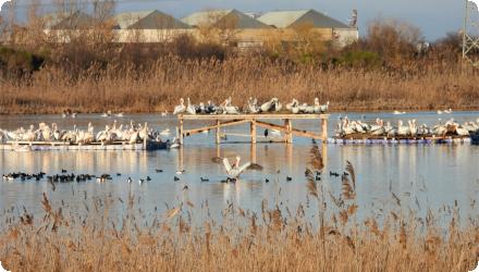
Rapid post-flood response (Belene/Persina, 2008): Within ~2 months of the first flooding, 10 new fish species were recorded in the restored area; ferruginous duck nesting pairs increased from 5 to 50, and mallard from 16 to 400. Bird numbers of 22 species were found to increase. Colonial waterbirds: Dalmatian pelican breeding recorded on Persina/Belene for the first time in ~60 years (2016).
Aquatic macrophytes: Water lilies (protected species) were reintroduced and have returned to Persina’s marshes following restoration actions.
Aquatic macrophytes: Water lilies (protected species) were reintroduced and have returned to Persina’s marshes following restoration actions.
Ecosystem impact climate regulation
No information available
Information on Ecosystem impact climate regulation
No info available
Information on Increased Evapotranspiration
Evaporation in the wetland will be as max about 1 m3/sec.
Ecosystem provisioning services
1
Information on Ecosystem provisioning services
Tourism development in the region, new employment opportunities, economic benefits due to fishery and biomass production.
Key lessons
The Persina wetland restoration shows that large-scale floodplain reconnection on the lower Danube is possible even in heavily altered landscapes. Restoring controlled hydrological connectivity through sluices and channels re-established seasonal flooding over thousands of hectares and triggered rapid ecological responses. The sudden return of fish diversity and waterbird colonies after the first flooding illustrates the resilience of floodplain ecosystems once hydrology is restored.
When many stakeholders are involved, longer groundwork is essential. Participatory approaches to restoration design proved critical for success, as the project depended on changing people’s perceptions of wetlands and securing full support from authorities and local communities. The work of the Protected Area Local Consultative Councils and targeted public-awareness campaigns effectively supported this involvement.
Controlled restoration has provided a platform for large-scale experimentation and for studying nutrient-trapping processes under real conditions. This approach allowed managers to adjust operations based on ecological feedback and hydrological performance.
A solid understanding of both the baseline conditions and the desired future ecosystem state should be embedded early in the design phase. While baseline water-quality and biodiversity data were collected, the project itself recognised that long-term monitoring—10 to 15 years—would be needed to fully assess nutrient retention and other hydrological benefits. The absence of easily accessible long-term datasets today limits the ability to quantify these outcomes.
The case also shows that restoration is not a one-off action. Follow-up measures such as hydraulic-structure maintenance, reintroduction of aquatic plants, and creation of nesting platforms have been essential to sustaining ecological gains and adapting to changing environmental conditions.
Success factor(s)
| Success factor type | Success factor role | Comments | Order |
|---|---|---|---|
|
Attitude of relevant stakeholders
|
<p>The intensive stakeholder involvement during design and implementation created strong ownership and sustainable Project outcomes</p>
|
1
|
|
|
Financing possibilities
|
<p>The overall co-financing proveded by government substantially exceeded amounts agreed at appraisal.</p>
|
2
|
|
|
Existing staff and consultant knowledge
|
<p>Bank and Gobernment cooperation was in timely attention to critical implementation issues.</p>
|
3
|
Driver
| Driver type | Driver role | Comments | Order |
|---|---|---|---|
|
Legal obligations
|
main driver
|
The Environmental Program for the Danube River Basin as a `preemptive measure to prevent river Danube and Black Sea water pollution from reaching catastrophic proportions`
|
1
|
|
Legal obligations
|
main driver
|
Danube Pollution Reduction program (DRP)
|
2
|
Flexibility adaptability
Adaptation to changing ecological and hydrologic conditions of Danube River can be achieved by flexible operation of the hydraulic facilities (sluices) in order to maintain optimal water regime.
Transferability
Similar restoration works could be designed for other riparian (former) wetlands along medium and large rivers in their lower segments.
The first follow-up Project, “Kaikusha”, under EU LIFE+ program helps develop feasibility studies to restore the Kaikusha Marshes in the Danube River basin.
The first follow-up Project, “Kaikusha”, under EU LIFE+ program helps develop feasibility studies to restore the Kaikusha Marshes in the Danube River basin.
Basin characteristics influence
The low inclination and the plain landscape along lower Danube allow the achievement of relatively large flooded areas with low-head structures. The large mean discharge of lower Danube makes difficult to assess the measure relative impact due to scale.
Cost effectiveness
Reducing nutrient loads in the Danube River. Total cost-effectiveness ratios were estimated at US$1.3 to US$5.0 per kilogram of Nand US$28.9 to US$46.2 per kilogram of P removed annually.
English