Last update
2025
Summary
Due to major developments over the past two centuries, the Eau Morte Valley (a tributary of Annecy Lake) has a hydrosedimentary dysfunction with incised areas and areas with sediment excesses and an alluvial marsh disconnected from flooding. To reduce the impacts of the river's floods on uses, and to prevent the risk of urban areas flooding, a functional restoration programme for the valley has been developed by the federation of municipalities of Annecy lake sources. It was based on the renaturation of the Eau Morte bed, the functional restoration of the Giez marsh and the construction of crossing structures. This work has given the marsh a role as a flood expansion area. This project was also carried out by involving local residents in a process of territorial dialogue so that they themselves would be actors in the area and would participate in its management.
Position
Latitude
45.7610
Longitude
6.2615
Project
NWRM
National Id
France_10
Installation date
2012-2023
Implementation Status
RBD code
FRD-Le Rhône et les cours d'eau côtiers méditerranéens
Transboundary
0
Photo gallery
Location of the project
The Eau Morte is the main tributary of the Annecy lake. Like its tributaries, the St Ruph and the Glière, it has its sources in the Bauges and Bornes mountains. The Giez marsh is located downstream of the valley, and the Eau Morte flows through it before flowing into Annecy Lake.
The headwaters of the Eau Morte Basin are very productive in terms of sedimentary materials, due in particular to the presence of suspended moraines. Its valley is an alluvial plain resulting from the progressive filling of an ancient lake by the progressive addition of sediments.
The headwaters of the Eau Morte Basin are very productive in terms of sedimentary materials, due in particular to the presence of suspended moraines. Its valley is an alluvial plain resulting from the progressive filling of an ancient lake by the progressive addition of sediments.
NUTS Code
FR71 - Rhône-Alpes
Project's objectives
Reduce the risk of flooding in the village of Faverges, directly upstream of the Giez marsh (golf and agricultural uses) and at the Sollier-Verthier level;
Reconnect the Giez marsh with the Eau Morte floods;
Restore sediment transit in the valley;
Restore ecological continuity between a spawning area favourable for trout and Annecy Lake;
Restore a mobility space for the watercourse downstream of the marsh upstream of the hamlet of Sollier.
Reconnect the Giez marsh with the Eau Morte floods;
Restore sediment transit in the valley;
Restore ecological continuity between a spawning area favourable for trout and Annecy Lake;
Restore a mobility space for the watercourse downstream of the marsh upstream of the hamlet of Sollier.
Involved Partners
| Authority type | Authority name | Role | Comments |
|---|---|---|---|
Climate zone
cool temperate moist
Temperature
11.2 °C
Annual rainfall range
1200 - 1500 mm
Elevation range
450 - 800
Slope range
High (20 %) upstream of Faverges
Low (0-5 %) downstream of Faverges
Low (0-5 %) downstream of Faverges
Vegetation class
Classic riparian vegetation, with some invasive species.
Water bodies: Ecological Status
Good
Water bodies: Chemical Status
Good
Project scale
Large
Project scale specification
Watershed-scale project.
Project area
166 ha
Area specifications
Divided into 5 sites
The choice of these NWRMs followed the diagnosis of hydrosedimentary dysfunctions in the Eau Morte Valley, which had highlighted the need to restore the hydraulic functioning of the Giez marsh, and to restore sediment transit in the valley. Their interest lay in the global approach applied throughout the valley.
Total cost
€ 2,851,853.2
Costs total information
Phase 1 (Functional restoration of the Mercier plain through renaturation) : € 723,061.60
Phase 2 (Reconnection of the Giez marsh) : € 147,931.00
Phase 3 (Restoration of ecological continuity in the town of Faverges) : € 1,881,313.40
Phase 4 (Restoration of a mobility space downstream of the marsh) : € 99,547.20
Phase 2 (Reconnection of the Giez marsh) : € 147,931.00
Phase 3 (Restoration of ecological continuity in the town of Faverges) : € 1,881,313.40
Phase 4 (Restoration of a mobility space downstream of the marsh) : € 99,547.20
Costs land acquisition information
The public services bought the land of willing private owners. The ones who kept ownership of their land had to finance their fair part of the project.
Financing authorities
Type of funding
Sub-national funds
Type of funding
Sub-national funds
Comments
Total : € 672,681.95
Phase 1 : € 71,438.49 (10 %)
Phase 2 : € 44,379.30 (30 %)
Phase 3 : € 581,074.00 (30 %)
Phase 4 : € 29,864.16 (30 %)
Phase 1 : € 71,438.49 (10 %)
Phase 2 : € 44,379.30 (30 %)
Phase 3 : € 581,074.00 (30 %)
Phase 4 : € 29,864.16 (30 %)
Type of funding
Sub-national funds
Comments
Total : € 418,799.97
Phase 1 : € 153,884.84 (20 %)
Phase 2 : € 31,051.70 (20 %)
Phase 3 : € 228,092.80 (12 %)
Phase 4 : € 5,770.63 (6 %)
Phase 1 : € 153,884.84 (20 %)
Phase 2 : € 31,051.70 (20 %)
Phase 3 : € 228,092.80 (12 %)
Phase 4 : € 5,770.63 (6 %)
Type of funding
EU-funds: Rural development funds
Comments
Phase 1 : € 357,312.27 (50 %)
Comments
Phase 3 : € 139,646.60 (7.4 %)
Comments
Phase 4 : € 11,781.66 (11,8 %)
Type of funding
Private funds
Comments
Phase 4 : € 2,808.71 (2.8 %)
Policy context
The project covers the Giez marsh, as well as two other areas: the Mercier plain, which is 2 km upstream of the marsh, and the village of Faverges, which is located directly upstream of the plain.
The Giez marsh is part of a complex of wetlands annexed to Annecy Lake, called the Cluse du lac d'Annecy. It is crossed by the Eau Morte, with which it is in piezometric equilibrium. It is made up of a mosaic of environments: molinia grasslands, terrestrial reed beds, alkaline low bogs, alluvial white alder forests and rivers. It has a rich biodiversity (400 plant species and 354 listed animal species), including protected species. The marsh belongs to the Natura 2000 site of the Cluse du lac d'Annecy, benefits from a biotope protection decree since 1990.
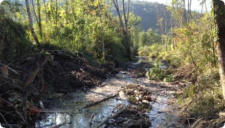
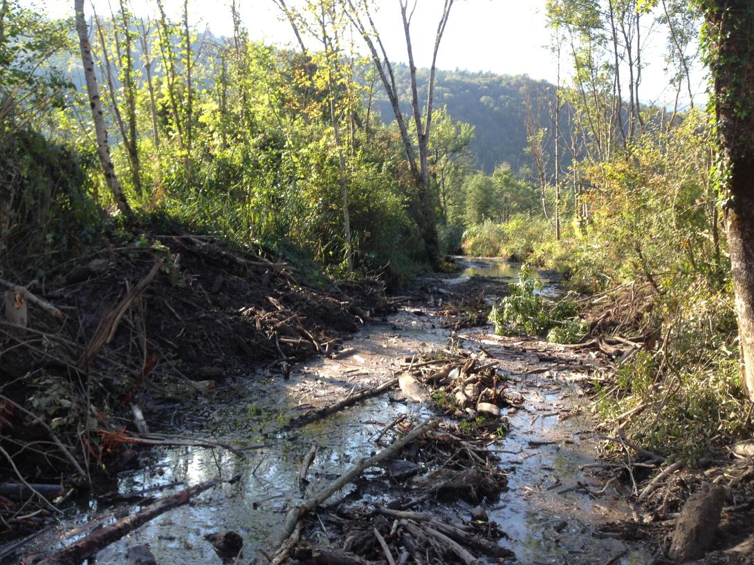
The marsh development work has led to its gradual disconnection from the watercourse that crosses it. An accumulation of ice jams at the entrance to the marsh caused an accelerated deposition of materials in the Eau Morte bed. It reached the level of the upper bank, causing overflows upstream of the marsh, and limiting sedimentary transit through it.
The Mercier plain occupies the alluvial valley of the Glière, and is covered by an alluvial forest. The watercourse is strongly incised, and is therefore disconnected from its major bed.
The village of Faverges is crossed by the Glière river. The bed of the river includes several crossing structures that cause breaks in ecological continuity and a risk of flooding during 100-year floods.
The Giez marsh is part of a complex of wetlands annexed to Annecy Lake, called the Cluse du lac d'Annecy. It is crossed by the Eau Morte, with which it is in piezometric equilibrium. It is made up of a mosaic of environments: molinia grasslands, terrestrial reed beds, alkaline low bogs, alluvial white alder forests and rivers. It has a rich biodiversity (400 plant species and 354 listed animal species), including protected species. The marsh belongs to the Natura 2000 site of the Cluse du lac d'Annecy, benefits from a biotope protection decree since 1990.
The marsh development work has led to its gradual disconnection from the watercourse that crosses it. An accumulation of ice jams at the entrance to the marsh caused an accelerated deposition of materials in the Eau Morte bed. It reached the level of the upper bank, causing overflows upstream of the marsh, and limiting sedimentary transit through it.
The Mercier plain occupies the alluvial valley of the Glière, and is covered by an alluvial forest. The watercourse is strongly incised, and is therefore disconnected from its major bed.
The village of Faverges is crossed by the Glière river. The bed of the river includes several crossing structures that cause breaks in ecological continuity and a risk of flooding during 100-year floods.
Land ownership
Parts are public land, including land bought specifically for this project. Some are private land, in which the land owners take the responsaiblity of the maintenance.
Community involvment
Yes
Design consultation activity
| Activity stage | Name | Key issues | Comments |
|---|---|---|---|
|
Screening phase
|
Dialogue weaving
|
Initial misunderstanding and conflicts between owners & municipality services.
|
Contact to all owners on the shore, discussions on river-related preoccupations. After the 2015 flood event.
|
|
Screening phase
|
Common strategy development
|
Integrating the preoccupations of all the stakeholders.
|
After 2015 and 2018 flood events, consultation with impacted inhabitants. Integration of their experience for the hydraulic model calibration. Public services and governance explaination. Action strategy construction and actions proposal.
|
Policy target
| Target purpose |
|---|
Policy pressure
| Pressure directive | Relevant pressure |
|---|
Pressures remarks
Accelerated deposition of solid material in the river
Flooding events
Flooding events
Policy impact
| Impact directive | Relevant impact |
|---|
Requirement directive
| Requirement directive | Specification |
|---|
Contractual arrangements
1
| Arrangement type | Responsibility | Role | Name | Comments |
|---|
Part of wider plan
1
Wider plan type
| Wider plan type | Wider plan focus | Name | Comments |
|---|---|---|---|
|
Catchment-based
|
Water
|
Contrat de bassin
|
Wateshed basin contract, which includes development work to be carried out and rules to be respected in the territory
|
Floral monitoring
The conservatory of natural spaces of Haute-Savoie carried out a monitoring of plant communities in the alkaline lowland sector of the Giez marsh.
In addition, monitoring according to the Rhomeo flore protocol was carried out in June 2014 and June 2019 in the Giez marsh, in order to calculate the floristic engorgement index, the floristic soil fertility index and the floristic quality index.
Piezometric monitoring
A piezometric monitoring was carried out by the conservatory of natural spaces of Haute-Savoie thanks to 4 piezometers.
A second monitoring will be set up by the federation of municipalities of Annecy lake sources, based on the 9 piezometers used in 2006 for the diagnosis of the valley, and still present on the site.
Hydraulic modelling
A hydraulic model of the marsh was developed by the project leader. It is used to assess the hydrological behaviour of the valley for a given flood.
Maintenance
Carried out by land owners. Removal of invasive species, log jams removal.
Floral monitoring
Piezometric monitoring
Hydraulic modeling
Piezometric monitoring
Hydraulic modeling
Flood safety.
Hydrological effects
Clear reduction of floodwater and solid material transportation. Smaller water level.
Information on Reducing flood risks, quantity
Two successive floods of similar intensity occurred in 2015 and 2018. In 2015, the golf course and agricultural land upstream of the marsh were flooded, while in 2018 they were not affected, and it was the marsh that filled with water. The diversion channel operated in the desired format: instead of having a direct supply from the Eau Morte, the diversion channel was supplied by overflows from the watercourse on the left bank.
The 2023 massive flood events did no damages to houses in the watershed, thanks to the restoration work. It highlights how much the work is successful.
The 2023 massive flood events did no damages to houses in the watershed, thanks to the restoration work. It highlights how much the work is successful.
Information on Other biophysical impacts
Landscape improvement.
Key lessons
As concerns floodrisk, the restored marsh perfectly played its water retention role in 2018 and 2023. The flood expansion took place in the marsh, avoiding upstream as well as downstrem impacts.
The overall watershed management strategy has been a success, showing that a common construction with stakeholders can be effective.
The overall watershed management strategy has been a success, showing that a common construction with stakeholders can be effective.
Success factor(s)
| Success factor type | Success factor role | Comments | Order |
|---|---|---|---|
|
Attitude of the public
|
main factor
|
<p>The 2015 flood then proved to be a lever for the conduct of the territorial dialogue and the involvement of local residents in the project. Today, the transversal approach between elected officials facilitates the implementation of flood prevention within a framework of upstream-downstream solidarity.</p>
|
Driver
| Driver type | Driver role | Comments | Order |
|---|---|---|---|
|
Organisation committed to it
|
main driver
|
A strong willingeness to explore restoration methods by the political decision makers.
|
Transferability
Reproductible in other watersheds with degraded rivers, but needs a solid governance and public participation.
It is already being mimicked in a neighboor watershed.
It is already being mimicked in a neighboor watershed.
Source(s)
English
Phase 1 : € 140,426.00 (20 %)
Phase 2 : € 72,500.00 (50 %)
Phase 3 : € 932,500.00 (50 %)
Phase 4 : € 49,322.00 (50 %)