Last update
2025
Summary
The EC LIFE programme’s co-financed project aims to restore the hydrological system in the Middle Basin of the Biebrza Valley to support the conservation of water-dependent habitats and open marshland bird species. It focuses on controlled water management and re-irrigation to halt the degradation of peatlands within the water system of the Rudzki Canal, Ełk River, Jegrznia River, and Woźnawiejski Canal. Key measures include constructing water retention infrastructure to maintain wetland conditions, especially during dry years.
Phase I (LIFE09, completed in 2016) included redirection of water flows, construction of barrages and thresholds, partial riverbed restoration, land acquisition, and mowing of overgrown areas across 9,000 ha. Phase II (LIFE13) is ongoing and expands interventions to an additional 13,452 ha, aiming to further restore wetland hydrology while maintaining agricultural and tourism use.
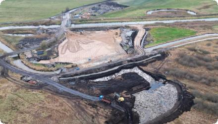
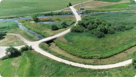
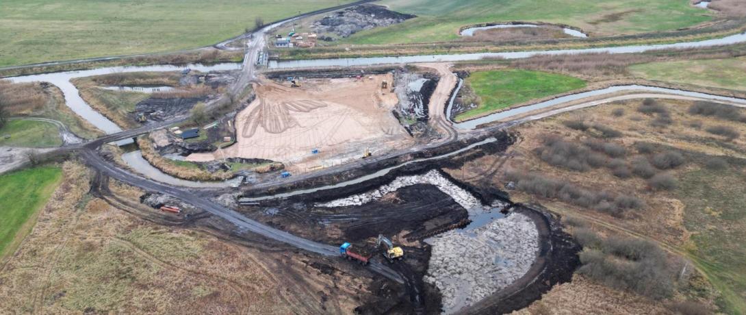
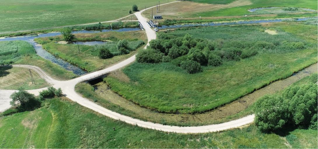
Recent works include the construction of a new hydrological junction at Modzelówka, designed to direct approximately 80% of the Kuwaski Canal's flow toward the Rudzki Canal and 20% to the reactivated Ełk riverbed. In 2023, a high-durability PE-HD siphon system was installed to support this redistribution, designed for minimal ecological impact. These efforts have already shown benefits such as improved groundwater retention, reduced fire risk, and better conditions for both biodiversity and local agriculture. Full implementation of Phase II is expected by 2026–2027.
Phase I (LIFE09, completed in 2016) included redirection of water flows, construction of barrages and thresholds, partial riverbed restoration, land acquisition, and mowing of overgrown areas across 9,000 ha. Phase II (LIFE13) is ongoing and expands interventions to an additional 13,452 ha, aiming to further restore wetland hydrology while maintaining agricultural and tourism use.
Recent works include the construction of a new hydrological junction at Modzelówka, designed to direct approximately 80% of the Kuwaski Canal's flow toward the Rudzki Canal and 20% to the reactivated Ełk riverbed. In 2023, a high-durability PE-HD siphon system was installed to support this redistribution, designed for minimal ecological impact. These efforts have already shown benefits such as improved groundwater retention, reduced fire risk, and better conditions for both biodiversity and local agriculture. Full implementation of Phase II is expected by 2026–2027.
Position
Latitude
53.602265
Longitude
22.734504
Project
NWRM
National Id
Poland_03
Implementation Status
RBD code
PL2000
Transboundary
0
Photo gallery
Location of the project
The case study is located in the Middle Basin of the Biebrza Valley, within Biebrza National Park, in northeastern Poland, primarily near the villages of Kuligi, Modzelówka, Ruda, and Brzeziny. It is situated east of the town of Goniądz, and lies between national road DK65 (Grajevo–Białystok) and voivodeship road DW668. The site encompasses the Jegrznia and Ełk river valleys, and includes parts of the Woźnawiejski and Kuwaski canals.
NUTS Code
PL34 - Podlaskie
Project's objectives
1. Restore the natural hydrological regime over a combined area of over 22,000 hectares (9,000 ha in Phase I, 13,452 ha in Phase II) in the Middle Basin of the Biebrza Valley.
2. Redirect water flows to restore wetland water conditions:
In Phase I: divert ~70% of Woźnawiejski Canal water back into the Jegrznia River.
In Phase II: divert ~80% of Kuwaski Canal flow into the Rudzki Canal and 20% into the old Ełk riverbed.
3. Improve conditions for hydrogenic habitats and Natura 2000 wetland species, particularly open marshland birds like the Aquatic Warbler (Acrocephalus paludicola).
4. Reduce peatland degradation, fire risk, and mineralisation by raising and stabilising water tables.
5. Build and modernise water infrastructure: 6 barrages and 1 threshold in Phase I, an hydrotechnical junction and siphon system in Phase II.
6. Mow or clear vegetation on hundreds of hectares of overgrown peatland to maintain open habitats.
7. Increase awareness and cooperation with local stakeholders, including landowners and farmers, through consultation and information campaigns.
Involved Partners
| Authority type | Authority name | Role | Comments |
|---|---|---|---|
Climate zone
cool temperate dry
Temperature
6.7
Precipitation
615
Annual rainfall range
600 - 900 mm
Evapotranspiration
10–15 mm/month in winter; ~25 mm in March, ~70 mm in May; and over 80 mm/month from June to August
Elevation range
115
Groundwater level
Natural groundwater occurs at shallow depths, typically 0.5 to 10.95 m, with most first aquifer levels between 1–3 m depth
Vegetation class
Peat-forming wetland vegetation, primarily consisting of:
Moss communities (Sphagnum species)
Sedge meadows (Carex species)
Reed beds (Phragmites australis)
Alder and willow shrubs in wetter areas
Moss communities (Sphagnum species)
Sedge meadows (Carex species)
Reed beds (Phragmites australis)
Alder and willow shrubs in wetter areas
Water bodies: Ecological Status
Moderate
Water bodies: Chemical Status
Failing to achieve good
Water quality status
Water quality is mainly impacted by historic drainage and peat degradation, causing nutrient release. Secondary pressures include diffuse pollution from agriculture. Restoration efforts aim to rewet peatlands and stabilize hydrological and nutrient cycles
Project scale
Meso
Project scale specification
The restoration project in the Middle Basin of the Biebrza Valley is implemented at the regional/river scale, covering approximately 22,000 hectares across phases I and II. It focuses on sub-basin hydrological restoration, specifically targeting the Jegrznia River – Ełk River – Rudzki and Woźnawiejski Canals system, within the Biebrza National Park. This places it clearly at the meso-scale, as it involves catchment-scale planning, regional water flow management, and restoration of hydrological connectivity across a portion of the larger Biebrza River basin, rather than a site-specific or national-level intervention.
Performance timescale
1 - 4 years
Project area
9000
Total cost
€ 10,314,274
Costs total information
Phase I (LIFE09) had a total eligible budget of approximately €3,672,468
Phase II (LIFE13) amounted to €6,641,806
Phase II (LIFE13) amounted to €6,641,806
Financing authorities
Type of funding
EU-funds: LIFE+
Comments
LIFE09 NAT/PL/000258
LIFE13 NAT/PL/000050
LIFE13 NAT/PL/000050
Compensations
0
Policy context
The main environmental problem is caused by a network of draining canals built in XIXth century under Russian Tsar administration which significantly lowered ground water table of neighbouring peatlands and changed habitat conditions in the region of two rivers – Jegrznia and Ełk as well as two canals: Rudzki and Woźnawiejski.
Land ownership
The land is mainly state-owned and managed by Biebrza National Park, with some areas privately owned and partially acquired during the project to support restoration.
Community involvment
Yes
Design consultation activity
| Activity stage | Name | Key issues | Comments |
|---|---|---|---|
|
Design phase
|
To implement the measures, the local spatial plan had to be ammended. Therefore SEA study was implemented, including public consultation.
|
Policy target
| Target purpose |
|---|
|
Improved Biodiversity
|
|
Increase Water Storage
|
|
Runoff control
|
Policy pressure
| Pressure directive | Relevant pressure |
|---|
Policy impact
| Impact directive | Relevant impact |
|---|
Requirement directive
| Requirement directive | Specification |
|---|
Contractual arrangements
0
| Arrangement type | Responsibility | Role | Name | Comments |
|---|
Part of wider plan
1
Wider plan type
| Wider plan type | Wider plan focus | Name | Comments |
|---|---|---|---|
|
Local spatial plan of Goniądz
|
The park authority monitors water levels, vegetation, and biodiversity indicators to assess ecological outcomes of restoration.
Monitored parameters include hydrological data such as surface and groundwater levels, peat soil moisture, and flow distribution across canals and riverbeds. Ecological indicators like plant community composition, extent of open wetlands, and presence of target bird species are tracked to evaluate habitat recovery. In selected areas, water quality monitoring includes nutrient concentrations (e.g., nitrogen and phosphorus) to assess the effect of peatland rewetting on water chemistry. Fire occurrence and peat mineralization risk are also monitored, especially during dry periods.
Maintenance
Regular mowing and upkeep of water structures are carried out by the Biebrza National Park to preserve habitats and maintain hydrological function.
Edge of Field/Plot
the methods involves field works, setting up monitoring sites for hydrological measurements
Local Jobs Creation : 4 positions at pelleting facility
Fuel Production : Biomass-based OTOPellet (~16 GJ per pellet)
Integration into 2014–2020 Rural Development Programme, securing agri‑environment subsidies
Cultural Preservation : Recognition and use of traditional knowledge in management planning
Fuel Production : Biomass-based OTOPellet (~16 GJ per pellet)
Integration into 2014–2020 Rural Development Programme, securing agri‑environment subsidies
Cultural Preservation : Recognition and use of traditional knowledge in management planning
Increased groundwater level
0.4
Information on Increased groundwater level
While the ground water level in the river is estimated to be increased, the growundwater level in the vicinity of channel will decrease.
Water quality overall improvements
Neutral impact-no change in WQ status
Information on Water quality overall improvements
The area is haveing minor economic activities, therefore change in water qyality is not monitored.
1
Habitat & Bird Population Growth : Managed area rose from 1,551 ha to 6,344 ha; Aquatic Warbler rose 26% (575 individuals)
Key lessons
Hydrological restoration must be systemic.
The project showed that restoring peatlands requires managing the full water network—rivers, canals, and groundwater—not isolated sections.
Monitoring enables adaptation.
A dense network of piezometers and gauges, linked to a DSS, allowed real-time tracking and flexible, evidence-based management.
Groundwater inflow is essential.
Modeling proved that even small increases in lateral groundwater recharge significantly improve peatland water balance and resilience.
Use of durable, low-impact materials is key.
PE-HD siphons were well suited to wetland conditions—long-lasting, corrosion-resistant, and minimally invasive.
Local economy and ecology can align.
Harvesting biomass for fuel (e.g. OTOPellet) helped manage vegetation, reduce fire risk, and support rural employment.
Land ownership matters.
Access to private land through purchase or agreement was vital to restore hydrological continuity and ecological function.
Restoration supports climate resilience.
Rewetting reduced drought and fire risks, while enhancing biodiversity and buffering climate extremes.
Success factor(s)
| Success factor type | Success factor role | Comments | Order |
|---|---|---|---|
|
Attitude of relevant stakeholders
|
main factor
|
The project is still in the implementation phase |
1
|
Driver
| Driver type | Driver role | Comments | Order |
|---|---|---|---|
|
Legal obligations
|
main driver
|
to protect biodiversity in the Park area
|
1
|
|
Availability of subsidies
|
main driver
|
LIFE+ funding provides co-financing for such activities
|
2
|
English
Construction works and ecological restoration
Monitoring and stakeholder coordination