Last update
2025
Summary
South of Bratislava, the Morava River and its tributaries were modified at three sites to restore wetland biotic complexes and enable movements between habitat fragments isolated by land use. Under the Biodiversity Protection Project (GEF/World Bank with national funds), four oxbows and over 19 km of floodplain were restored.
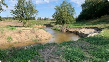
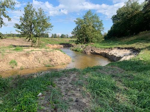
Building on this, Slovakia is implementing a new, larger restoration phase funded by the national Recovery and Resilience Plan. The state water manager (SVP) is restoring a 17-km section of the Morava (river km 69–51.9) across the cadastres of Sekule, Moravský Svätý Ján, Malé Leváre, Veľké Leváre and Gajary, based on a VÚVH study (2021). Planned measures include reconnection of side arms/oxbows, local bank lowering/softening, selective removal of bank protection and targeted re-meandering with natural materials to improve floodplain inundation, groundwater storage, water quality and ecological connectivity. Completion is currently targeted for June 2026.
Building on this, Slovakia is implementing a new, larger restoration phase funded by the national Recovery and Resilience Plan. The state water manager (SVP) is restoring a 17-km section of the Morava (river km 69–51.9) across the cadastres of Sekule, Moravský Svätý Ján, Malé Leváre, Veľké Leváre and Gajary, based on a VÚVH study (2021). Planned measures include reconnection of side arms/oxbows, local bank lowering/softening, selective removal of bank protection and targeted re-meandering with natural materials to improve floodplain inundation, groundwater storage, water quality and ecological connectivity. Completion is currently targeted for June 2026.
Position
Latitude
48.0575
Longitude
17.207
Project
NWRM
National Id
Slovakia_01
Installation date
1998-06
Contact
REC
RBD code
SK40000
Transboundary
1
Photo gallery
Location of the project
Lower Morava River (Slovakia-Austria border), south of Bratislava, in the river reach km 69-51.9. Within the cadastral areas of Sekule, Moravský Svätý Ján, Malé Leváre, Veľké Leváre and Gajary; inside Záhorie Protected Landscape Area and the “Morava River Floodplains” Ramsar/Natura 2000 complex.
NUTS Code
SK01 - Bratislavský kraj
Project's objectives
Protect and strengthen biodiversity in three representative ecosystems incl. the Morava Floodplains; restore wetland biotic complexes and reconnect fragmented habitats.
On the Morava, the works targeted partial restoration of side-arms; the case records 4 oxbows and >19 km of floodplain restored. (These figures describe the intended/achieved scope of that phase.)
- reconnect cut-off meanders/side arms
- remove bank revetments to trigger natural lateral dynamics
- locally lower natural levees to increase frequency/duration of floodplain inundation
- optimise the scheme to respect Q100 flood-protection levels, ice regime, and habitat diversity
The active project aims to restore ~17 km of the Morava by reconnecting side arms/oxbows, restoring floodplain inundation and river processes, to improve groundwater storage/quality and ecological status/connectivity; works also entail large-scale earthworks (~360,000 m³).
Involved Partners
| Authority type | Authority name | Role | Comments |
|---|---|---|---|
Climate zone
cool temperate moist
Temperature
10,8
Precipitation
600
Annual rainfall range
600 - 900 mm
Runoff coefficient
0,25
Elevation range
117
Vegetation class
Floodplain meadows (Cnidion dubii alliance) and softwood alluvial forests (willow–poplar; Salici-Populetum) typical of the Morava floodplain complex.
Water bodies: Ecological Status
Poor
Water bodies: Chemical Status
Failing to achieve good
Water quality status
Strong hydromorphological alteration - uniform channel, poor habitat diversity, limited lateral connectivity, bed incision and floodplain deposition - linked to past river regulation.
Project scale
Meso
Project scale specification
Regional/river-segment project within the Lower Morava floodplain corridor (SK–AT border), not a nationwide programme nor a single local reach.
Area subject to Land use change or Management/Practice change (ha)
250
Some stretches of natural river beds and fluvial processes remain especially in the Morava River and its tributary, the Rudava.
The area is theoretically protected at this time as national parks, nature reserves or landscape protected areas
Total cost
2326658
Costs total information
2300000(GEF Project Grant)+870000(Co-financing Total)= 3170000 USD
Restoration-Morava: 256000USD --> 187972 €
Restoration-Morava: 256000USD --> 187972 €
Information on Economic costs - income loss
70000USD
Financing authorities
Type of funding
Other
Type of funding
National funds
Type of funding
EU-funds: LIFE+
Compensations
0
Policy context
Biodiversity degradation through pollution, overuse by visitors and complex impacts from adjacent land uses. The forests have been cut, water table reduced, and spring floods interrupted and the native meadows have been converted to cropland.
The floodplain forests have been reduce. the water table has dropped and spring floods have been interrupted. Large areas of meadow were ploughed up and converted in to arable fields. the once continuous flood plain area has been transformed into a mosaic of remnant natural areas and areas of intensive management.
The floodplain forests have been reduce. the water table has dropped and spring floods have been interrupted. Large areas of meadow were ploughed up and converted in to arable fields. the once continuous flood plain area has been transformed into a mosaic of remnant natural areas and areas of intensive management.
Land ownership
Mixed ownership : Agricultural land is mostly used by cooperatives/private firms, water bodies are state-owned, forests within the Ramsar are mixed.
Community involvment
No
Design consultation activity
| Activity stage | Name | Key issues | Comments |
|---|---|---|---|
|
Design phase
|
Workshops
|
in the slovak Republic with management and research personnel and the Slovak ministry of environment Department of Nature and Landscape conservation. Designed to provide key interventios and develop institutional capacieities and the focus of activity will be on three areas.
|
Policy target
| Target purpose |
|---|
|
Improved Biodiversity
|
Policy pressure
| Pressure directive | Relevant pressure |
|---|
Policy impact
| Impact directive | Relevant impact |
|---|
Requirement directive
| Requirement directive | Specification |
|---|
Contractual arrangements
1
| Arrangement type | Responsibility | Role | Name | Comments |
|---|---|---|---|---|
|
Contractual agreement
|
GLOBAL ENVIRONMENT TRUST FUND GRANT AGREEMENT
|
between Slovak Republic (the Recipient) and International Bank for Reconstruction and Development
|
Part of wider plan
1
Wider plan type
| Wider plan type | Wider plan focus | Name | Comments |
|---|
VÚVH/SHMÚ run the national WFD-aligned monitoring of water status, while ŠOP SR/CHKO Záhorie monitor Natura 2000 features in the Morava floodplain.
Monitored elements include biological quality elements (fish, benthic invertebrates, macrophytes), physico-chemical indicators (e.g., nutrients, oxygen/organic load; priority substances), and hydromorphology/hydrology in line with WFD methods; groundwater is monitored in dedicated networks.
Maintenance
SVP, as river manager, undertakes routine and project-related upkeep on the Morava reach (vegetation clearance, channel function and bank works).
To protect ecological zones of substantial international importance, reduce loss of species, restore ecosystems and maintain a high level of diversity. Forested innovation by integration of various levels of biological diversity to address issues in conservation planning.
The project complements other activities such a Bank-financed forestry development loan and GEF-supported protection activities. Components of the project are also directed to integrating planning outside the strictly protected areas in consultation with affected communities and interests.
Employment / social inclusion (SK, 2025): >130 people from social enterprises are employed alongside SVP crews (clearing woody growth, improving meander through-flow). Government notes the aim is to integrate disadvantaged job-seekers and improve regional living conditions.
Land administration (SK, 2025): SVP reports ~90% of land arrangements concluded in the project area; expropriation notices state the works should not prevent continued use of remaining parcels. (Administrative/social dimension of delivery.)
Public outreach & cross-border exchange (SK–AT, 2023): INTERREG Kli-Ma project held public events and education for children/general public on Morava water-level optimisation and climate adaptation.
Agriculture & rural income (SK, Ramsar case): programme to convert ~150 ha to species-rich meadows and support management of ~1,000 ha via direct farmer subsidies; anticipated outcomes include higher hay production improving owners’ income, benefits for hunting/fishing associations, and more tourism.
Trough research and monitoring in these areas, knowledge will be gained as to how human activities have affected, and are affecting, different types of ecosystems and habitats, and how this actions can be changed to keep these areas and the societies that depend on them, healthy.
Information on retained water
After oxbow reconnection (1990s): The rock-weir design caused side arms to behave like reservoirs (inflow > outflow), with very low velocities (<0.1 m s⁻¹) and rapid infilling: in one meander ~43,000 m³ of sediment accumulated in 2 years—an unexpected negative impact that degraded the reconnections.
Long-term groundwater level declined ~0.9–1.2 m (1958–1994) in the central/upper border reach, linked to bed incision and regulation (context, not a measured effect of the 1990s works). Danube backwater can reach ~23 km upstream, influencing levels.
Current RRF project (r.km 69–52): aims to restore floodplain inundation, groundwater storage and water quality via side-arm reconnections and bank lowering; no published post-work impact data yet (works ongoing to 2026).
Information on increased water storage
Arable lands now are meadows where water stay for longer periods of time.
Water quality overall improvements
N/A info
Soil quality overall soil improvements
N/A info
1
The floodplain hosts >850 plant species and valuable aquatic macrophytes; the 1990s works reopened several meanders, but no quantified change in species richness/abundance for the Slovak sites was found in accessible sources.
Ecosystem impact climate regulation
Not relevant for the specific application
Key lessons
Institutional stability is a key condition for project success; professional development is a vital step in building human capacity; explicit targets help managers identify the success, cost-effectiveness and basic usefulness of most components throughout implementation; involving NGOs during implementation were key to success.
Early oxbow reconnections (1990s) showed that design choices matter: rock-weir intakes created low velocities, high sediment inputs and rapid blockage of meander entrances. Nine years of eco-hydromorphological monitoring concluded the benefits were short-lived and conditions worsened without sufficient flow dynamics.
From this, practitioners derived clear technical lessons: analyse present river processes before acting; evaluate effects on flow and sediment transport with models; and avoid copy-pasting measures to dissimilar rivers. Alternatives such as full meander integration were proposed to restore dynamics; lower-outlet reconnection alone would need continuous maintenance.
Later project phases reflect that learning: the current 17-km restoration is based on Water Research Institute (VÚVH) studies and numerical/physical modelling (“Plan of measures… km 69–51.9, Variant 2, 2021”), in line with national restoration guidance published by VÚVH/MŽP SR.
Finally, the river is transboundary. Results and acceptance improve when actions align across the corridor: Austrian LIFE works on the Lower Morava reconnected multiple side arms and islands, illustrating the benefit of coordinated, reach-scale planning on both banks.
Success factor(s)
| Success factor type | Success factor role | Comments | Order |
|---|---|---|---|
|
Attitude of decision makers
|
secondary factor
|
<p>Qualified and very committed professionals within the PMCU</p>
|
3
|
|
Existing staff and consultant knowledge
|
secondary factor
|
<p>Establishment of the Joint Scientific Advisory committes proved usefull for provideing guidance to the project activities and specially for increasing awareness of the project among the national and international scientific and academic community.</p>
|
4
|
Driver
| Driver type | Driver role | Comments | Order |
|---|---|---|---|
|
Organisation committed to it
|
main driver
|
1
|
Transferability
Highly transferable to lowland meandering rivers where regulation cut off side-arms. Success depends on process-based design: secure enough through-flow to avoid silting, model hydraulics/sediment, and plan for bank lowering and selective revetment removal only where flood-safety and ice-regime remain acceptable. Address land tenure early, coordinate across borders, and budget for maintenance and WFD-aligned monitoring.
Source(s)
English