Last update
2025
Summary
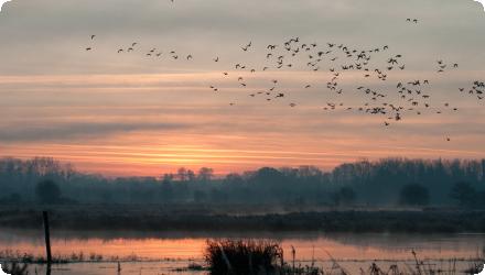
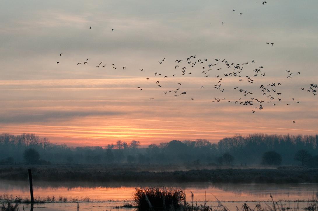
Since 1984, the Ille-et-Vilaine Hunting Federation has been restoring a 550-ha peat marsh heavily drained and cropped in the 20th century. Maize fields were converted to hay meadows and pasture through agreements with farmers; a peat bog and a reedbed were restored; and water levels are artificially managed to enable winter flooding. The Méleuc was re-routed into a more natural course. The goals (improve staging conditions for migratory waterbirds and recover marsh functions (carbon sequestration, natural water purification)) have been met for bird use, while water-level management still needs optimisation. Recent sources add that the site forms part of the Ramsar “Bay of Mont-Saint-Michel” and its Natura 2000 network; roughly 380 ha are held by FDC35 and the Foundation for the Protection of Wildlife Habitats. A major reedbed project (“Bois de la Mare”) cleared poplar/spruce to restore ~16 ha of phragmites as compensation linked to the Mont-Saint-Michel maritime project, awarded France’s Ecological Engineering Prize in 2018. Management relies on mowing then grazing via agreements with about twenty farmers; hunting is excluded except targeted wild-boar control, and guided public activities are now offered. In 2021 the regional scientific council (CSRPN) issued a favourable opinion toward designation as a Regional Nature Reserve over a 768-ha perimeter (process ongoing). Winter counts report up to c. 6,000 anatids.
Position
Latitude
48.5687
Longitude
-1.9140
Project
NWRM
National Id
France_09
Installation date
1984-ongoing
Implementation Status
RBD code
FRG-La Loire, les cours d'eau côtiers vendéens et bretons
Transboundary
0
Photo gallery
Location of the project
Included in the vast Dol marshes (10,500 ha), the Châteauneuf marsh is a regularly flooded depression made up of peaty alluvium and juxtaposing the Mont-Saint-Michel bay.
NUTS Code
FR52 - Bretagne
Project's objectives
The initial objective was only the creation of an area for the wintering of anatidae. All the other environmental and hydrological objectives came after.
Involved Partners
| Authority type | Authority name | Role | Comments |
|---|---|---|---|
Climate zone
cool temperate moist
Temperature
11.9°C
Annual rainfall range
600 - 900 mm
Elevation range
27 m
Slope range
0-1 %
Vegetation class
Mosaic dominated by wet hay/pasture meadows and reedbeds (Phragmites), with sedge/fen patches, ponds/canals, hedgerows and some woodland.
Water bodies: Ecological Status
Moderate
Water bodies: Chemical Status
Good
Water quality status
Historic drainage + maize monoculture → hydrologic dysfunction; summer drying drives peat mineralization and eutrophication risks; raising summer levels faces stakeholder conflict.
Project scale
Micro
Project scale specification
It targets a single marsh site (≈370–550 ha) with localized hydromorphological and habitat measures within the Mont-Saint-Michel bay wetland complex.
Performance timescale
< 1 year
Project area
392 ha
Area specifications
Land belonging to the Hunting Federation (392 ha in 2024, increasing each year with land acquisitions). The whole marsh is about 550 ha.
The Hunter Federation undertook to acquire land on the marsh, to carry out ecological engineering work to restore the wetland from the agricultural field, then to maintain and manage the land, notably with a sluice gate system.
There are 4 pillars identified for this marsh restoration to work :
- sluice gate for flooding in winter
- maintain minimum water levels in summer
- Bring back the river (Meleuc) into its original bed
- drain at the end of spring, ideally on June 1st
This last pillar is not followed, as the opening of sluice gates is on 1st of april instead.
- sluice gate for flooding in winter
- maintain minimum water levels in summer
- Bring back the river (Meleuc) into its original bed
- drain at the end of spring, ideally on June 1st
This last pillar is not followed, as the opening of sluice gates is on 1st of april instead.
The deployed mesaures were selected in the first place because they allowed the creation of habitats favorable to biodiversity and waterfowl parking.
However, the complete restoration of the hydrological functioning of the marsh has not been completed. The measures therefore need to be complemented by water level management by means of a valve.
However, the complete restoration of the hydrological functioning of the marsh has not been completed. The measures therefore need to be complemented by water level management by means of a valve.
Total cost
Millions of euros
Costs total information
Over € 100,000 - 120,000 per year, for land aquisition, ecological engineering, maintenance, communcation & animation s for the public.
Financing authorities
Type of funding
Sub-national funds
Comments
Funds for land acquisition
Type of funding
Private funds
Compensations
0
Policy context
The marsh belongs to the complex of peripheral wetlands of the Bay of Mont-Saint-Michel, and as such plays a role in welcoming birds, especially during migration and winter. It is thus a migratory stage for the Aquatic Warbler, a passerine species classified as "vulnerable" on a global scale by IUCN and also the most threatened in Europe. The interest of the site also concerns other faunal groups as well as the flora, hosting some species that are uncommon or rare on the scale of Brittany. It is the most massive peat deposit in the region.
Until 1950, it included one residual lake (the Mare de St-Coulban), before it was dried out. The marsh has since been drained by the Meleuc river, which shows a strong recalibration. Before the project, the marsh was subject to an intensive agricultural use, mainly for corn. It included a former peat bog that had been mined and drained.
Until 1950, it included one residual lake (the Mare de St-Coulban), before it was dried out. The marsh has since been drained by the Meleuc river, which shows a strong recalibration. Before the project, the marsh was subject to an intensive agricultural use, mainly for corn. It included a former peat bog that had been mined and drained.
Land ownership
Co-owned mainly by FDC35 and the Foundation for the Protection of Wildlife Habitats (FPHFS): ~380 ha of ~550 ha; FDC35 manages the site.
Community involvment
No
Design consultation activity
| Activity stage | Name | Key issues | Comments |
|---|
Policy target
| Target purpose |
|---|
Target Remarks
Restore wet habitats, especially peat meadows;
Improve the marsh's carrying capacity for biodiversity, and in particular birdlife;
Improve the regulatory role of the marsh (carbon sequestration in peat, natural water purification);
Allow educational and recreational uses;
Enhance the value of the Hunting Federation of Ille-et-Vilaine Department action on the management of sensitive heritage habitats;
Collaborate with agricultural stakeholders.
Policy pressure
| Pressure directive | Relevant pressure |
|---|
Pressures remarks
The pressures on the site result from its development in the middle of the last century to facilitate agricultural activities: Corn monoculture; Hydrological dysfunction causing the marsh to dry up in both winter and summer, and promoting peat mineralization.
Policy impact
| Impact directive | Relevant impact |
|---|
Requirement directive
| Requirement directive | Specification |
|---|
Contractual arrangements
1
| Arrangement type | Responsibility | Role | Name | Comments |
|---|---|---|---|---|
|
Contractual agreement
|
Collective agreement between the Hunting Federation and the Authorized Syndicate Association "Digues et Marais du Dol".
|
Agreement on the water management of the marshland: sluice gates to be opened on April 1st each year. Minimal water levels are to be maintained in summer and winter in the marsh.
|
||
|
Contractual agreement
|
In exchange for free access to ome marshland areas, farmers commit to comply with strict land-use practices, including:
- Adherence to mowing and grazing calendars - Prohibition of phytosanitary products, fertilizers, and supplemental feeding - Preservation of hedgerows and flooded habitats |
Collective agreement between the Hunting Federation and the farmers operating marshland areas.
|
This agreement has to be approved yearly, from May 1st to November 1st. In 2024, 260 ha were exploited by 21 different farmers.
|
|
|
Institutional arrangement
|
The Water Agency finances the Federation for land aquisition and public animations, in exchange for respecting good practices.
|
Territorial contract between the Lorie-Bretagne Water Agency and the Hunting Federation of Ille-et-Villaine
|
||
|
Organisational arrangement
|
An agreement on the marsh management in construction. It is supposed to include automatic managemetn system for the valves.
|
It aims at resolving the growing tensions between the Hunting Federation and the local authorities and farmers.
|
Règlement d'eau (project, 2025)
|
An agreement shall be reached in 2025, or a decision will be taken by the prefect.
|
Part of wider plan
0
Wider plan type
| Wider plan type | Wider plan focus | Name | Comments |
|---|---|---|---|
|
Catchment-based
|
Environment & Biodiversity
|
Wetlands of the Bay of Mont-Saint-Michel
|
Piezometric monitoring: 20 piezometers have been installed and monitored monthly since 2016.
Physico-chemical monitoring: A physico-chemical probe is installed on the marsh and measures water transparency, conductivity, dissolved oxygen, water pH, water height and silt depth. Recurring samplings are made by the hunting federation.
Ecological monitoring: A monitoring of amphibians, reptiles (laying 80 herpetological plates), fish and aquatic invertebrates was carried out. The Large Marsh Grasshopper population has been monitored since 2019.
The floral procession evolution is monitored in oligotrophic and peaty areas by applying a National Museum of Natural History methodology to record the communities evolution.
Bird counts have been carried out by the Hunting Federation of Ille-et-Vilaine Department for 30 years. Since 2016, they have been supplemented by a winter waterbird count, a monitoring of the reedbed passerines, ardeidae and anatidae reproduction. A mapping of the singing passerines is also carried out. Monitoring of odonates and butterflies was carried out between 2017 and 2022.
Maintenance
Minimal intervention (only the removal of fallen trees on a pathway for eg.), and valves maintenance.
Piezometric, physico chemical and ecological monitoring before and after the application.
The farmers who work on the marsh plots proposed by the hunter federation can exploit the field for free, keep for themselves all hay produced and are eligible to PAC.
The creation of a natural regional parc was helped by the presence of the Black Marsh, as a good argument on nature conservation in the territory.
The creation of a natural regional parc was helped by the presence of the Black Marsh, as a good argument on nature conservation in the territory.
Social
The outreach program is funded by eco-contribution : 400 schoolchildren per year plus nature-related, cultural, and recreational events for the public. This programme targets local population instead of tourism.
Hydrological effects
The measures implemented are very effective in absorbing winter floods.
Maintenance baseflow
1
Information on Maintenance baseflow
Low water times are reduced, but could be even more if the valves were opened later than 1st of april as they are today.
Since the Meleuc river has been brought back into its natural course, there is water flowing permanently.
Since the Meleuc river has been brought back into its natural course, there is water flowing permanently.
Information on Reducing flood risks, quantity
The 2025 winter floods in the department showed an efficiency of the marsh to absrob the flood water. Areas in the north of the department were protected, unlike the south parts which suffered more damages.
Information on Water quality overall improvements
A visual observation of the area allowed the Departmental Hunting Federation to observe a decrease in eutrophication in the canals. The purification effect of the plants is clearly observed.
In 2022, massive drought caused water quality and qantity problems, with cyanobacteria blooms in particular.
In 2022, massive drought caused water quality and qantity problems, with cyanobacteria blooms in particular.
1
The 200 ha core of the marsh has a restricted access, in favor of birds nesting and reproduction.
An increase in waterbirds halting;
An increase in breeding passerines;
An evolution of the common flora towards a more specific procession of peaty environment flora;
An increase in the geographical distribution of the Large Marsh Grasshopper, which is a good indicator of a well-preserved peat bog ecosystem.
The restoration of the reedbed has allowed the installation of paludiculous birds, like the Marsh Warbler which has only a few nests in Bretagne.
Information on Ecosystem impact GHG soil carbon
There is no confirmed carbon capture yet, but the project managed to slow down the opposite dynamic. The maintenance of minimum water levels even in summer prevents the peatland mineralization and carbon emissions.
Information on Mitigation other biophysical impacts
Piezometric monitoring confirmed that the marsh dries out in the summer following the opening of the gates. The water levels obtained are too low to preserve the peat, and expose it to mineralization.
Key lessons
Overall and after 35 years of effort, the marsh has become again a waterbird halting with EU importance in the Mont-Saint-Michel bay. A lot of invertebrates are present while the typical plant community of a peat bog is hindered by the water level management still to be improved. In light of the measures implemented, they are very effective in absorbing winter floods, but clearly insufficient to address climate and biodiversity challenges. The hunting federation would want to increase the water levels in summer to avoid peat mineralisation but the farmers who are growing maize are against.
A public outreach program (for schools, events) provides additional social benefits.
A public outreach program (for schools, events) provides additional social benefits.
Success factor(s)
| Success factor type | Success factor role | Comments | Order |
|---|---|---|---|
|
Attitude of decision makers
|
main factor
|
Determination of the Hunter Federation of Ille-et-Vilaine, to keep the restoration and managemetn project running event through constant oppositions of the local authorities and farmers. |
1
|
|
Other
|
main factor
|
Land control and capacity for action of the federation : No need to get different opposing actors to agree on every little action. |
2
|
|
Financing possibilities
|
secondary factor
|
The access to many financing projects (funds, compensation measures of the Mount St Michel Bay, etc.) accross the years allowed to reach amitious goals of restoration. |
3
|
Driver
| Driver type | Driver role | Comments | Order |
|---|---|---|---|
|
Other
|
secondary driver
|
Recognition of the work efficiency and importance leads to more public acceptance for further rstoration work. For example :
- The 2015-2016 reedbed restoration in the marsh has won the 2018 Ecological Engineering Prize in Category 5 – "Habitat Restoration" (A-IGEco yearly contest). - The improved biodiversity lead to the designation of the site as a Sensitive Natural Area (ENS) by the Ille-et-Vilaine Department in 2024 |
Transferability
This kind of project is technically easily reproductible ; however it needs lots of determination, political support and financing.
The most damaged areas are where there is the greatest gain in regeneration.
The most damaged areas are where there is the greatest gain in regeneration.
Source(s)
English