Last update
2025
Summary
Located in Pays de la Loire and Nouvelle-Aquitaine, the Marais Poitevin is France’s second-largest wetland. About 2,148 ha of municipal flood meadows (“marais communaux”) are collectively grazed and managed, delivering flood storage, groundwater recharge and pollutant removal. Management agreements launched in 1989 and renewed in 2003 and 2017 sustain traditional, low-intensity mixed grazing and biodiversity. Since the 2010s, hydraulic governance has been reinforced by EPMP’s “Contrats de marais”, which define seasonal water-level bands and fund small hydraulic works, habitat restoration and monitoring within territorial contracts (CT 2023–2025). Real-time hydrometric tracking is provided through the SIEMP portal. Today, 23 communal marshes across 23 municipalities host roughly 3,600 cattle and horses each season; in 2019, 121 farmers grazed 2,113 ha. In November 2023 the wider Marais Poitevin (69,034 ha) was designated a Ramsar Site, and since October 2024 the LIFE “Maraisilience” project (2024–2029) has been mobilising stakeholders to co-design climate adaptation and a climate observatory. These updates confirm the flood-meadow system’s continued role in water regulation and nature conservation under modern, multi-partner governance.
Position
Latitude
46.3
Longitude
-0.8
Project
NWRM
National Id
France_02
Installation date
1989
Implementation Status
Contact
Guillaume Michel, ACTeon
RBD code
FRG
Water body code
Sèvre Niortaise et Marais Poitevin
Transboundary
0
Photo gallery
Location of the project
The Marais Poitevin is located in Western France. This is the second largest wet area in France (about 100 000 ha). It is astride two administrative regions (Pays de la Loire and Poitou-Charentes) and three Département (Vendée, Deux-Sèvres and Charente-Maritime). It is located between the cities of La Roche-sur-Yon (to the North), La Rochelle (to the South) and Niort (to the East). The Atlantic Ocean is located to the West of the Marais Poitevin. Common floodmeadows cover about 2000 ha. They are located near the Northern and Southern borders of the Marais Poitevin.
NUTS Code
FR51 - Pays de la Loire
Project's objectives
Primary: regulate hydrological cycle & flows, conserve biodiversity; secondary: purification, flood mitigation across ~2,000 ha, with winter–spring inundation.
Involved Partners
| Authority type | Authority name | Role | Comments |
|---|---|---|---|
Climate zone
cool temperate moist
Temperature
12.8 °C
Precipitation
867
Annual rainfall range
600 - 900 mm
Elevation range
3 m
Slope range
0-1%
Vegetation class
Extensive wet grasslands/flood-meadows with micro-relief (“baisses” wet hollows, “belles” dry hummocks), clayey soils; communities of grasses/sedges/rushes with sub-saline meadow species such as Ranunculus ophioglossifolius favored by extensive grazing.
Water bodies: Ecological Status
Moderate
Water bodies: Chemical Status
Failing to achieve good
Water quality status
Diffuse nitrates & pesticides, eutrophication; Ludwigia invasions; hydromorphology & water-level regulation constraints; quantitative deficits in dry years.
Project scale
Meso
Project scale specification
23 common meadows, 2148 ha. A network of communal meadows across multiple municipalities, governed by park/municipal/EPMP instruments (“contrats/protocoles de marais”) at sub-basin scale.
Performance timescale
Unknown
Project area
2148
Area subject to Land use change or Management/Practice change (ha)
2148
Size
2148
Size unit
ha
Bring together agricultural/economical issues and environmental issues.
Responsibility of farmers (administrative procedures for farmers in order to avoid problems in the common meadows).
Common meadows should provide incomes to municipalities.
Responsibility of farmers (administrative procedures for farmers in order to avoid problems in the common meadows).
Common meadows should provide incomes to municipalities.
Design capacity description
The common meadows play a central role in the water management of the Marais Poitevin. The volume of stored water is hard to estimate. Depending of the year, the 2148 ha are totally or partly flooded from October/November to Mars/April.
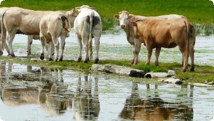
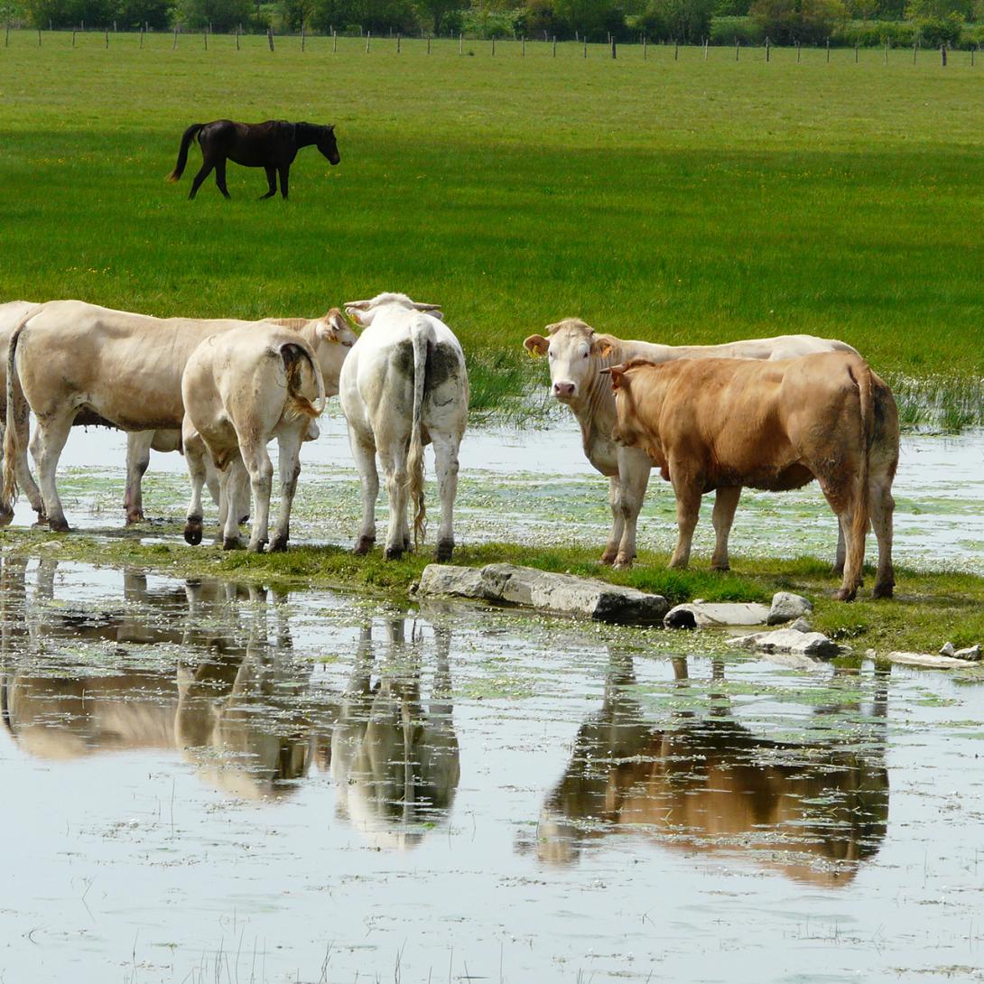
Common floodmeadows are used as a pasture for 10 centuries. Pasture by multi-specific herd (cattle, horses, gooses) went on because it is a good way to valorize the produced biomass and to maintain ecosystems and landscapes. Soil structure (micro relief) prevented from using machinery for mowing and ecosystem services (flood protection, water purification, role in water circle…) would have been lost if such areas were used for cropping. They are common land owned by municipalities.
Positive influence effectiveness
Good management of water levels throughout the year
Negative influence effectiveness
Bad management of water levels throughout the year (water in late spring), health problems of cattle.
Financing authorities
Type of funding
Other
Comments
Funds from environmental associations (LPO and WWF): 15 €/year for each hectare of common floodmeadow (450 000 € for the 15 years of the agreement). These supports are for the involved municipalities.
Type of funding
Local funds
Type of funding
EU-funds: Rural development funds
Comments
Agri-environmental payments for farmers and for the municipalities since 1993 (or 1997 for some of the floodmeadows).
Compensations
1
Compensations basis information
Common meadows are not rented by farmers. However, farmers have to pay a tax to municipalities when they benefit from services such as the health monitoring of the herd, maintenance of common meadows, fences, etc.). Amount of the tax : about 280 €/head
Farmers benefit from the CAP subsidies (including agro-environmental measures) in exchange for respect of agri-environmental and climate good practices.
Farmers benefit from the CAP subsidies (including agro-environmental measures) in exchange for respect of agri-environmental and climate good practices.
Policy context
For 10 centuries, these areas were used as pastures by local farmers. Local environmental conditions (floods, presence of salt in the soil, etc.) and management by humans (pasture…) created very specific ecosystems. In the 1970s and 1980s, only a few breeders used the meadows. Ecosystems as well as all services provided by these common meadows (regulation of water cycle, flood protection…) were endangered. Municipalities (owners of the common meadows) discussing with the Parc Naturel Régional du Marais Poitevin in order to change the management of meadows. An management agreement was found in 1989.
Land ownership
Municipalities own the flood-meadows (“marais communaux”), managed collectively with farmers under agreements since 1989.
Community involvment
Yes
Design consultation activity
| Activity stage | Name | Key issues | Comments |
|---|---|---|---|
|
Screening phase
|
Awareness actions
|
Awareness actions (for example in the framework of the Life programme) for inhabitants and users.
|
Policy target
| Target purpose |
|---|
|
Increase Water Storage
|
|
Groundwater Recharge
|
|
Pollutants Removal
|
|
Improved Biodiversity
|
|
Oher Societal Benefits
|
Target Remarks
Regulation of hydrological cycle and water flow,
Biodiversity and gene-pool conservation in riparian areas,
Natural assimilation (purification) of effluents through dilution, dispersion, and physicchemical processes,
Flood control and flood risk mitigation.
Biodiversity and gene-pool conservation in riparian areas,
Natural assimilation (purification) of effluents through dilution, dispersion, and physicchemical processes,
Flood control and flood risk mitigation.
Policy pressure
| Pressure directive | Relevant pressure |
|---|
Pressures remarks
The main pressure was the abandonment of floodmeadows. They were not used any more as pastures. This was a pressure for ecosystems.
Policy impact
| Impact directive | Relevant impact |
|---|---|
|
Floods Directive identified impact
|
Economic Activity
|
|
Floods Directive identified impact
|
Rural Land Use
|
|
Floods Directive identified impact
|
Property
|
|
Floods Directive identified impact
|
Other environmental impacts
|
Requirement directive
| Requirement directive | Specification |
|---|
Contractual arrangements
1
| Arrangement type | Responsibility | Role | Name | Comments |
|---|---|---|---|---|
|
Agreement for an agri-environmental management
|
Since 1989, 18 municipalities have undertaken to maintain common meadows and to respect environmental clauses. In compensation, municipalities receive financial and technical supports.
|
|||
|
agri-environment commitment
|
Since 1993, common floodmeadows are subject to agri-environmental measures (2nd pillar of the CAP)
|
Part of wider plan
1
Wider plan type
| Wider plan type | Wider plan focus | Name | Comments |
|---|---|---|---|
|
Environment & Biodiversity
|
Life Nature
|
Life Nature Project for "the conservation of the most remarkable habitats and species of Marais Poitevin" for the period 2004-2008.
In the framework of this project, one action on common floodmeadows has been developed (partnership between the PIMP, LPO, WWF and 16 municipalities). The objective of this action was to maintain and develop floodmeadows in order to ensure the hydrological equilibrium of Marais Poitevin, to improve its role of water purification and to preserve biodiversity and landscapes. Partners supported municipalities (technical and financial supports) for: - Carrying out management plans in order to plan future development and maintenance projects. - Ecological maintenance of floodmeadows in order to improve their ability to welcome remarkable species. - Ecological inventories and scientific monitoring in order to assess the relevance of projects and their benefits for the society. - Awareness actions for inhabitants and users about floodmeadows, their management and their richness. |
|
|
Environment & Biodiversity
|
Natura 2000
|
Since 1993
|
|
|
Agriculture
|
Common Agricultural Policy
|
Launched in 1962, the EU’s common agricultural policy (CAP) is a partnership between agriculture and society, and between Europe and its farmers.
The meadows are managed in compliance with the agri-environmental and climate measures of the CAP. |
Farmers are responsible for the monitoring of their herds. Health monitoring, animal identification, etc. is the responsibility of the Parc with the cooperation of farmers.
Maintenance
Maintenance of common meadows is the responsibility of municipalities (with the support of the Parc)
No assessment
No assessment
Economic benefits:
- For municipalities: source of incomes
- For farmers: common meadows are used as pastures
- For inhabitants: increase of the value of neighboring goods (houses…) - Tourism, etc.
Social benefits:
- Very important for creating social links between stakeholders (farmers, managers, elected representatives, inhabitants, NGOs…)
Hydrological effects
Common floodmeadows play an important role in the hydraulic management of the Marais Poitevin. A system of channels, sluices, etc. is used in order to manage the water level.
Information on Increased groundwater level
During the winter season, water is stored at the surface of the common meadows. This contributes to the recharge of groundwater reserves.
Information on Reducing flood risks, quantity
Floodmeadows store a large amount of water (surface but also groundwater). This helped avoiding floods in some inhabited areas.
Ecosystem flood control volume
Flood security and protection
Water quality overall improvements
Positive impact-WQ improvement
Information on Water quality overall improvements
Floodmeadows contribute to the purification of water. This is particularly important for shellfish farming downstream the Marais Poitevin. Benefits of improved coastal water quality and ecological status for a sustainable commercial production of shellfish with human health and welfare values.
1
Very important role for biodiversity (very specific fauna and flora).
Amenities (associated to habitat protection): fish and plants, tourism, recreation, and others.
Amenities (associated to habitat protection): fish and plants, tourism, recreation, and others.
Biomass production
Key lessons
The Marais Poitevin is the 2nd largest wetland in France. About 2000 ha of floodmeadows are owned by local municipalities and commonly managed by local farmers. Such meadows play an important role for water regulation. For instance, they contribute to the storage of water during flood events, to groundwater recharge, to the removal of pollutants, etc. In the 1980s, in reaction to their destruction, management agreements between municipalities, the Parc Interrégional du Marais Poitevin and environmental NGOs as well as agreements between municipalities and farmers were signed. They reinforce the traditional agri-environmental management (pluri-specific pastures: cattle, horses, gooses) in order to preserve the numerous services provided by the Marais Poitevin.
It seems very important to establish a relationship of trust between stakeholders (particularly between farmers, municipalities and the Parc Interrégional du Marais Poitevin). This is time- and energyconsuming (many dialogues, to make sure that everybody can give its opinion…) but it helps anticipating problems and finding solutions and it improves the acceptability of the measure through time and through difficulties which may occur. Building and maintaining social links (also with inhabitants and other stakeholders) should not be neglected.
It seems very important to establish a relationship of trust between stakeholders (particularly between farmers, municipalities and the Parc Interrégional du Marais Poitevin). This is time- and energyconsuming (many dialogues, to make sure that everybody can give its opinion…) but it helps anticipating problems and finding solutions and it improves the acceptability of the measure through time and through difficulties which may occur. Building and maintaining social links (also with inhabitants and other stakeholders) should not be neglected.
Success factor(s)
| Success factor type | Success factor role | Comments | Order |
|---|---|---|---|
|
Successful coordination between authorities
|
main factor
|
Close relationship and trust between farmers, municipalities and the Parc. This is helped by the governance scale (important role of municipalities, direct interaction between municipalities and farmers…) |
1
|
Driver
| Driver type | Driver role | Comments | Order |
|---|---|---|---|
|
Other
|
Common floodmeadows are used as a pasture for 10 centuries. Pasture by multi-specific herds (cattle, horses, gooses) went on because it is a good way to valorize the produced biomass and to maintain ecosystems and landscapes. Soil structure (micro relief) prevented from using machinery for mowing and ecosystem services (flood protection, water purification, role in water circle...) would have been lost if such areas were used for cropping. They are common land owned by municipalities.
|
1
|
Flexibility adaptability
This case study is closely linked to the very specific property rights regimes of flood meadows (common lands owned by inhabitants of municipalities).
Transferability
Transferable to lowland polder/wet-meadow systems with public/communal tenure, stakeholder consensus, and controllable hydraulics. Caution: property-rights context, invasive-species pressure, and multi-actor water-level trade-offs.
Cost effectiveness
No assessment
English
The park is involved in technical supports (management of breading and health issues on the common floodmeadows...)