Podravska region/Pesnica/Gačnik
| Authority type | Authority name | Role | Comments |
|---|---|---|---|
Climate
Annual Averages:
Geography
Water quality
Študija primera OPTAIN za porečje reke Pesnice se nahaja v severovzhodni Sloveniji, znotraj panonske podnebne regije, ki je razvrščena kot hladno zmerno vlažna. Območje se giblje na nadmorski višini od 100 do 500 metrov in pokriva približno 137 km². Povprečna letna količina padavin se giblje od 900 do 1100 mm, s povprečno letno temperaturo 9,5 °C. Hidrološko gledano letni odtok na območju znaša med 300 in 600 mm, povprečna letna evapotranspiracija pa je ocenjena na 550–650 mm. Teren ima povprečni naklon 14 %, kar prispeva k površinskemu odtoku in eroziji na kmetijskih območjih. Prevladujoči vrsti tal sta kambisoli in luvisoli, z gladino podtalnice od 5 do 50 metrov globoko. Glede na ocene iz člena 4 okvirne direktive o vodah je ekološko stanje vodnih teles ocenjeno kot slabo (2021). Kemijsko stanje v matriki biote (vključno s snovmi PBT) kaže slabo oceno z nizko stopnjo zaupanja, medtem ko ocene vode in biote brez snovi PBT kažejo dobro stanje s srednjo stopnjo zaupanja. Pokrajina se uporablja predvsem za poljščine, s precejšnjimi območji trajnih travnikov in mešane gozdne vegetacije, ki vse vplivajo na dinamiko infiltracije in zadrževanja vode v porečju.
Scale of the project
Size of the project
Principles
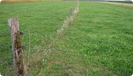
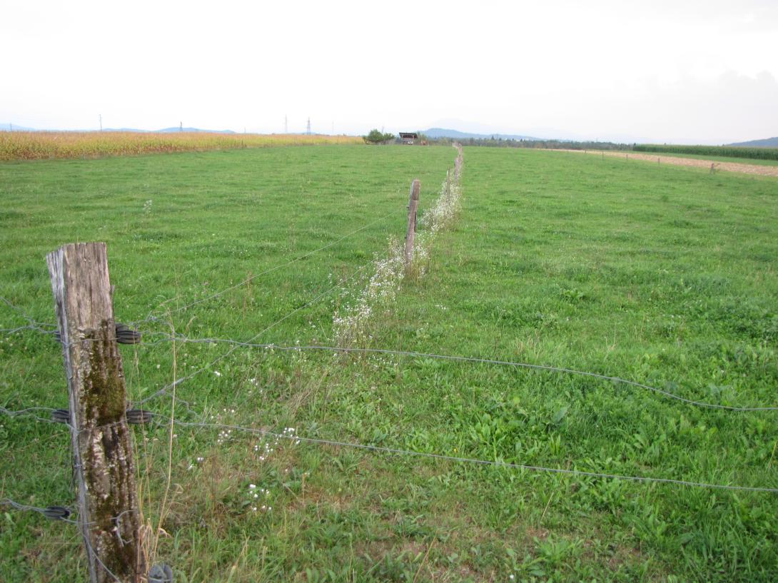
Cropland area was converted to permanent grassland or pasture land by sowing of grass and by a fence as protection. Grazing is organized in a rotation system between suckler cow's pasture and paddocks.
The purpose of the technology is to use the natural potential of the soils. As soils are shallow with low water holding capacity permanent grassland is much more resilient and adapted to the drought; permanent grassland needs not only less water, but as well less nutrients. Grass has the capacity to grow well after any rainfall event at any time of the growing period. During drought when, maize fields get dry, grasslands subsist and just wait until the rain falls. While maize yield is lost in drought years, grassland can sustain and nurrish animals until mid-autumn. Another advantage of grassland is its building up of organic matter in the soils.
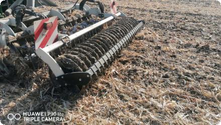
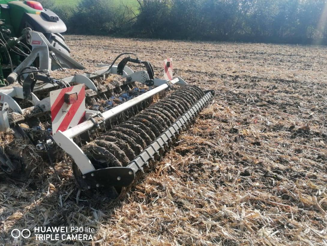
Mulch-till: (also called “conservation agriculture” or “minimum tillage”) is a method of land management with modified, less intensive tillage, where land is covered with plant residues year-round (at least 30% cover) or grass, energy consumption is reduced, and there is less trampling/ compaction of the soil because of fewer machine passes and the protected surface. Under mulch-till, special agricultural machinery and attachments are required. Disc harrows and chisel ploughs are used to loosen the soil, and direct drills are employed for seeding.
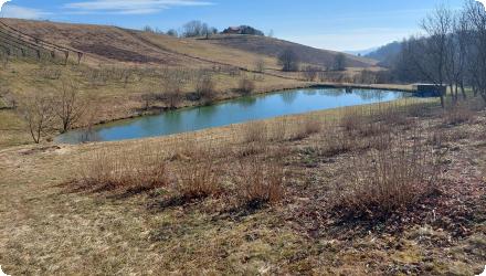
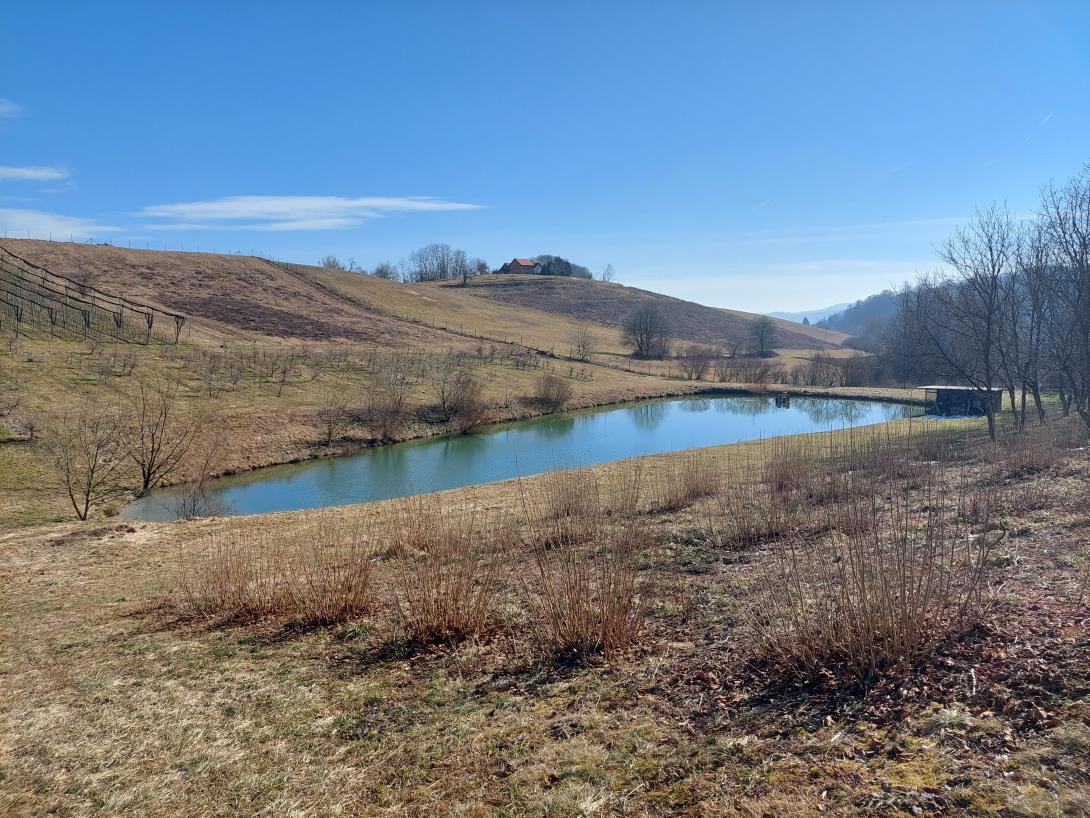
Retention ponds: “Retention ponds” comprise both simple, small ponds (up to 2000 m3, up to 4 m deep) and larger, more complex reservoirs (greater than 2000 m3). Retention ponds are designed to provide storage capacity to attenuate surface runoff during rainfall events. Each consists of a permanent ponded area with landscaped banks. Retention ponds achieve both storm water attenuation and water quality treatment through supplementary storage capacity of runoff. Water is then released at a controlled rate once the risk of flooding has passed. The technology can be applied in a natural or human environment. Before construction of a pond it is essential to follow legislation, which covers conditions and restrictions for the given location. Once a site is selected, technical documentation is prepared: first the conceptual design, then documentation for obtaining opinion, consent and a building permit. Later there is also project documentation for implementation. If the water is to be used for other purposes as well (e.g. for irrigation), it is necessary to plan for usage and environmental impact. Retention and still water promotes pollutant removal through sedimentation, while aquatic vegetation and biological uptake mechanisms offer additional treatment. Retention ponds are effective in removing urban pollutants and improving water quality.
| Land use change type | Comment |
|---|---|
|
Ni prišlo do večjih sprememb rabe zemljišč. Ukrepi so bili vključeni v obstoječe rabe kmetijskih zemljišč. Za varovalne pasove in žive meje je bila potrebna določena prostorska prilagoditev, zadrževalni ribniki pa so bili nameščeni na obrobnih ali manj produktivnih zemljiščih. |
Izbranih in izvedenih je bilo pet novih ukrepov za upravljanje s toplogrednimi vodami (NSWRM): nizkotalilno kmetijstvo, zadrževalni ribniki, zeleni pokrov, kolobarjenje, varovalni pasovi in žive meje. Zasnova je temeljila na lokalnem znanju in je bila prilagojena terenskim razmeram z uporabo instrumentov financiranja, ki so že na voljo slovenskim kmetom. Izvajanje je bilo preprosto, stroškovno učinkovito in usmerjeno v izboljšanje varstva tal, zadrževanja vode in odpornosti kmetij z minimalnimi motnjami v obstoječi rabi zemljišč.
Details of the costs
Mulch till : equipment procurement : 63 500 EUR
Retention pond: Document preparation, planning permission, construction of pond: 73 600 EUR
Riparian Buffer Strips and Hedges: Periodic mulching, mowing, or manual cutting (chainsaw work); removal of invasive species; occasional replanting or gap filling.
Green Cover / Cover Crops: Annual seed purchase and sowing; field preparation; potential herbicide or mowing costs for cover termination. These are recurring agronomic costs, varying by crop type and seasonal conditions.
Low Till Agriculture: Ongoing costs are related to specific machinery operations (e.g. disc harrows, no-till seeders). Costs depend on field size, soil condition, machine maintanance and fuel/labor inputs.
Crop Rotation:
No direct maintenance costs, but crop selection and planning must consider nutrient needs, pest cycles, and market viability. Minor administrative or advisory costs may apply.
Crop Rotation: Ongoing costs depend on the specific crop grown in each rotation year. These include variable production costs such as seeds, fertilizers, plant protection products, labor, and machinery use — all considered standard farm operational expenses.
Riparian Buffer Strips and Hedges: Regular inspection; vegetation control through mulching; selective cutting and trimming with chainsaw; removal of invasive species.
Green Cover: Monitoring of cover crop establishment; re-sowing if cover is insufficient; control of unwanted species; soil condition checks.
Low Till Agriculture: Annual review of soil structure and compaction; equipment maintenance; occasional weed pressure monitoring (especially where herbicide use is reduced).
Crop Rotation: Planning and documentation of rotation cycles; monitoring nutrient balance and soil health; adjusting rotation based on market and ecological feedback.
| Authority name | Type of funding | Financing share | Comments | |
|---|---|---|---|---|
|
National funds
|
Provides funding through agricultural subsidies and non-refundable investment support under national and EU rural development programs.
|
|||
|
Sub-national funds
|
Offers returnable financial instruments such as soft loans and guarantees to co-finance sustainable rural and environmental investment projects.
|
|||
|
Other
|
For agronomic measures (e.g. low till, green cover, buffer strips), annual maintenance is supported through CAP subsidies
|
| Activity stage | Name | Key issues | Comments | |
|---|---|---|---|---|
| Target purpose | |
|---|---|
|
Runoff control
|
|
|
Peak-flow reduction
|
|
|
Groundwater Recharge
|
|
|
Increase Water Storage
|
|
|
Pollutants Removal
|
| Policy area type | Policy area focus | Name | Comments | |
|---|---|---|---|---|
| Wider plan type | Wider plan focus | Name | Comments | |
|---|---|---|---|---|
| Requirement directive | Specification | |
|---|---|---|
|
Water Framework Directive (WFD) 2000/60/EC
|
||
|
Nitrate Directive (NiD) 91/676/EEC
|
Izvajanje NSWRM je vodila kombinacija sodelovanja kmetov, nacionalnih svetovalnih služb in zakonskih zahtev, zlasti v primerih gradbenih del, kot so zadrževalni ribniki. Javni kmetijski svetovalci so podpirali načrtovanje in odločanje, regulativni okviri pa so zagotavljali tehnično skladnost. Izvedeni NSWRM so namenjeni predvsem naslednjim političnim ciljem: nadzoru poplav, blažitvi suše in odtekanju hranil. Te ureditve upravljanja in oblikovalske odločitve pomagajo uskladiti lokalne ukrepe s širšimi direktivami EU in političnimi cilji.
Večina vzdrževalnih dejavnosti v študiji primera temelji na praktičnih izkušnjah in posvetovanjih s kmeti in ne na formalnem dolgoročnem testiranju. Redne naloge vključujejo upravljanje vegetacije okoli varovalnih pasov, pregled ribnikov in občasno odstranjevanje mulja. Agronomski ukrepi, kot sta zelena odeja in kolobarjenje, se vzdržujejo z rutinskimi kmetijskimi dejavnostmi. Čeprav ni vzpostavljenega namenskega dolgoročnega sistema spremljanja, so bila opazovanja in ocene uspešnosti opravljene med obiski na terenu in sejami za sodelovanje deležnikov.
Impact assessement methodology
The application of mulch-till on farm plots has had significant ecological impact, decreasing surface run-off and evapotranspiration. Soil moisture and cover has also been improved while reducing soil compaction, soil loss and crusting. Finally, it is thought to have a beneficial impact in decreasing the impact of droughts.
The installation of retention ponds in the agricultural landscape has resulted in both socio-economic and ecological impacts. In socio-economic terms, their presence increases crop production and reduces the risk of crop production failure. It is also thought to contribute to improving irrigation water quality. In ecological terms, retention ponds increase water quantity by harvesting and collecting water and surface run-off. It is also anticipated that they will reduce climate change risks associated with flooding and drought events,
| Success factor type | Success factor role | Comments | Order |
|---|---|---|---|
|
Other
|
main factor
|
Low-impact requirements |
|
|
Available support tools
|
main factor
|
Simple design, minimal land use change |
|
|
Attitude of relevant stakeholders
|
Awareness of local water and soil management challenges |
| Driver type | Driver role | Comments | Order |
|---|---|---|---|
|
Public pressure
|
main driver
|
Visibility of local hydrological issues
|
|
|
Public pressure
|
main driver
|
Eutrophication of Lake Pernica
|
|
|
Other
|
main driver
|
Soil erosion control
Climate resilience Soil conservation Water retention in the landscape Biodiversity improvement |
Izvajanje NSWRM je pokazalo znatno variabilnost stroškov, na katero so v veliki meri vplivali pogoji, specifični za lokacijo, in dejavniki, specifični za kmetijo. Medtem ko nekatere prakse, kot so obvodni varovalni pasovi in pokrovni posevki, lahko vključujejo relativno zmerne naložbe, druge – kot sta zastirka ali zadrževalni ribniki – zahtevajo znatne začetne stroške. Vsi ukrepi so pokazali velik potencial za zagotavljanje več ekosistemskih storitev, med drugim izboljšano zadrževanje vode, zmanjšan odtok in erozija, boljše zdravje tal ter povečana biotska raznovrstnost.