Last update
2025
Summary
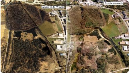
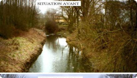
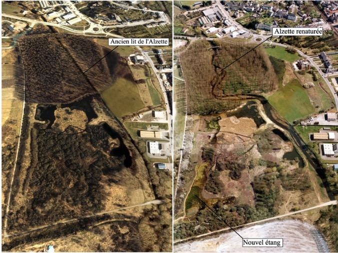
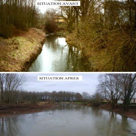
The Alzette river restoration at “Am Brill” (Schifflange) reversed earlier channelisation that had uniformised the river and impoverished habitats. The project re-meandered the channel (+140 m length), raised and widened the bed (summer/winter profiles), and removed an artificial dyke to reconnect the river to existing ponds; a new pond was also created. Works were delivered in 2000 over ~600–700 m as part of the LIFE-Nature project “Ecological valorisation of the upper Alzette.” Reported outcomes include ≈30 cm reduction of high-water levels, ~20,000 m³ of floodplain storage, a delayed flood peak (~15 min) and shorter peak duration (42→24 min), together with improved self-purification capacity and habitat diversity. Since completion, the site has been opened to the public via a 3 km interpretive nature trail (2005), and in 2024 it was incorporated into the nationally protected “Brill – Am Pudel” reserve, confirming its long-term conservation status and management.
Position
Latitude
49.509026
Longitude
6.007891
Project
NWRM
National Id
Lux_03
Installation date
2000-2001
Implementation Status
RBD code
LU RB_000
Transboundary
0
Photo gallery
Location of the project
The project area extends between the bridge providing access to the motorway and the pedestrian bridge downstream of the ARBED railway in the locality "Am Brill" in Schifflange.
NUTS Code
LU00 - Luxembourg
Project's objectives
Restore natural planform and floodplain, reconnect ponds, enhance habitats for farmland/wetland birds; locally +140 m river length, ~20,000 m³ flood storage, ~30 cm reduction in peak stage; part of a corridor where 41 ha were purchased and >5 km restored by 2006.
Involved Partners
| Authority type | Authority name | Role | Comments |
|---|---|---|---|
Climate zone
cool temperate moist
Temperature
9.2
Precipitation
853
Annual rainfall range
600 - 900 mm
Elevation range
285 m
Vegetation class
Restored wet meadows (6510, 6410 Molinia meadows), alluvial alder/ash riparian forest (91E0), and hydrophilous tall-herb fringes (6430), with ponds/oxbows. Extensive grazing is used for management.
Water bodies: Ecological Status
Bad
Water bodies: Chemical Status
Failing to achieve good
Water quality status
Historic channelisation, urban/industrial pressures and wastewater/CSO impacts; locally the Alzette was “relatively polluted,” hence ponds are connected only during floods to avoid low-flow contamination.
Project scale
Micro
Project scale specification
Single, site-specific reach at Schifflange (~700 m between the motorway access bridge and the footbridge below the ARBED railway), with local hydromorphological works and pond reconnection.
Performance timescale
< 1 year
Size
700
Size unit
m
Design capacity description
The project was designed to restore the natural functioning of the river.
No main constrain identified.
Total cost
€700,000
Costs total information
The investments were essentialy dedicated to filling and clearing works.
Costs investment
€ 600,000
Costs investment information
The investments were essentialy dedicated to filling and clearing works.
Costs operation maintenance information
No information available
Financing authorities
Type of funding
EU-funds: LIFE+
Comments
8,400,000 LUF ≈ €208,231
Type of funding
National funds
Policy context
A flood in Schifflange happened in 1998. A proposition for a project was elaborated afterwards. The main objective was to restore the natural reserve "Am Brill" and to prevent flooding.
Land ownership
Mixed ownership: communal (Schifflange) plus other owners; parcels were also acquired by Fondation Hëllef fir d’Natur under the LIFE Alzette project; the area is now a national nature reserve (“Brill–Am Pudel”).
Community involvment
No
Design consultation activity
| Activity stage | Name | Key issues | Comments |
|---|
Policy target
| Target purpose |
|---|
|
Peak-flow reduction
|
|
Improved Biodiversity
|
Target Remarks
The sponge measure tackles floodplain disconnection, flood risk at Bestgen Mill, and ecological impoverishment from channelisation.
Policy pressure
| Pressure directive | Relevant pressure |
|---|
Policy impact
| Impact directive | Relevant impact |
|---|
Requirement directive
| Requirement directive | Specification |
|---|
Contractual arrangements
0
| Arrangement type | Responsibility | Role | Name | Comments |
|---|
Part of wider plan
0
Wider plan type
| Wider plan type | Wider plan focus | Name | Comments |
|---|
Unknown
No information available
No information available
Retained water
60000
Retained water unit
m3/day
Information on retained water
The water storage restoration contributed to 15 mintutes delay of the peak flow. The maximal flow duration were reduced frome 42 to 24 minutes. Documented: increased storage (~20,000 m³), ~30 cm decrease in high-water levels locally, slower velocities, later/shorter flood peaks downstream, +140 m channel length and reconnection of ponds to the flood regime.
Increased water storage
20,000 m3
Reducing flood risks quantity change
Lowering of the high water level by approximately 30 cm. Flood delay and shortening of the duration of maximum flow downstream.
Water quality overall improvements
Positive impact-WQ improvement
Information on Water quality overall improvements
Positive effects on water quality are expected due to the restoration of the ecosystem self-purification, but no assessment has been realised yet.
Soil quality overall soil improvements
N/A info
1
Biodiversity improvement was expected.
Ecosystem impact climate regulation
No information available
Key lessons
The Alzette river restoration project aimed at erasing the effect of the river chanelling, which caused the river uniformisation and an ecological impoverishment.
The project consisted in a remeandering, increase of the base level of the river, widening of the riverbed, reconnection of the river to existing ponds and creation of a new pond. The project contributed to restore the flood plain, to prevent flooding and erosion, to restore the natural functionning of the river, to improve the self purification capacity, to improve biodiversity and to intergrate the river in the natural landscape.
Its success lead to further renaturation for the river, for example in the city Steinsel (Alzette and its tributary river Pétrusse) in 2023.
Success factor(s)
| Success factor type | Success factor role | Comments | Order |
|---|
Driver
| Driver type | Driver role | Comments | Order |
|---|---|---|---|
|
Past flooding events
|
main driver
|
A flood event occurred in Schifflange in 1998.
|
1
|
Transferability
Highly transferable to channelised lowland rivers with floodplain space and off-line ponds. Key enablers: land purchase/exchange, multi-benefit design, public access. Cautions: stakeholder/landowner negotiations can be complex; ensure water-quality is considered in (dis)connecting wetlands.
English