Last update
2025
Summary
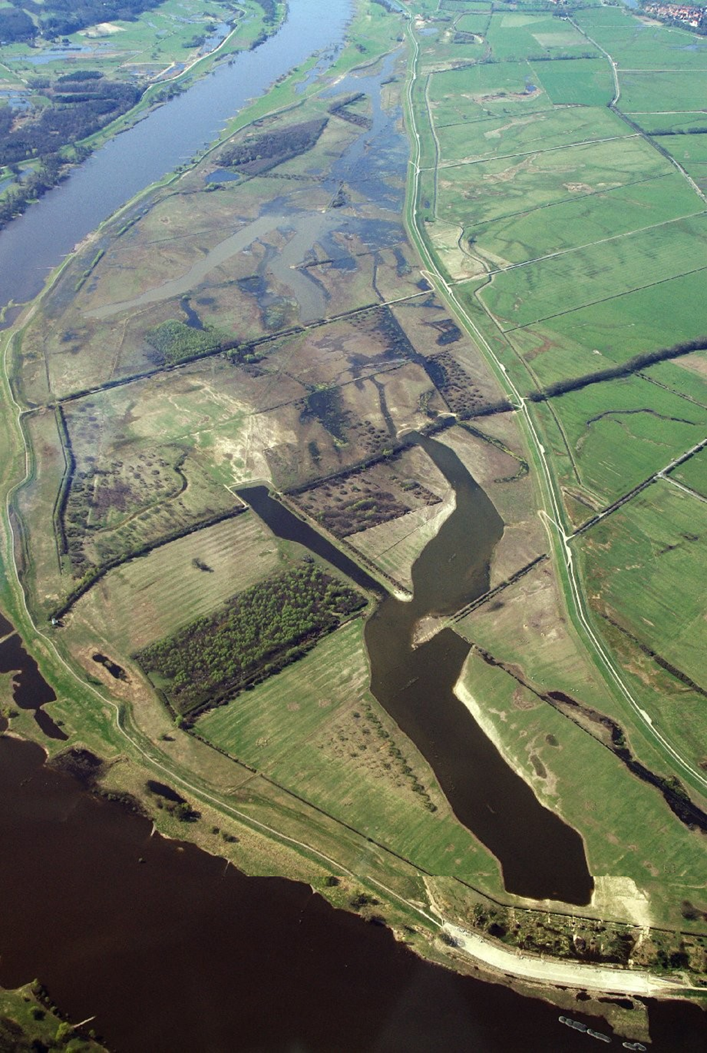
In the framework of the large-scale nature conservation project "Lenzener Elbtalaue", a dyke along the river Elbe (in Germany) has been relocated. This created a new retention area with a diverse floodplain, including alluvial forests, half-open pasture landscapes and other typical habitats of lowland floodplains. With 420 ha it is the biggest application of this type of measure in Germany so far. The project successfully combines flood protection and nature conservation objectives. Since the cutting of the old dyke in 2009, the measure could proof its effectiveness during several high water events.
The specific measures applied include:
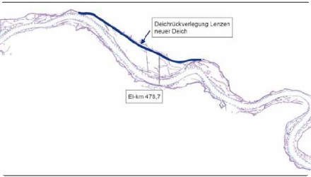
- Construction of a new, 6.1 km long dyke which has been shifted backward up to 1.3 km
- Opening of the old, 7.2 km long dyke, situated close to the river, in sections of 200-500 m length
- Planting of 160 ha of alluvial forest, with further 130 ha of succession areas for alluvial forests
- Establishment of half-open pasture landscapes on 85 ha
- Profiling of 45 ha of flood channels in the area concerned by the relocated dyke
- Implementation of a land re-organization process in order to make areas available for the project
The specific measures applied include:
- Construction of a new, 6.1 km long dyke which has been shifted backward up to 1.3 km
- Opening of the old, 7.2 km long dyke, situated close to the river, in sections of 200-500 m length
- Planting of 160 ha of alluvial forest, with further 130 ha of succession areas for alluvial forests
- Establishment of half-open pasture landscapes on 85 ha
- Profiling of 45 ha of flood channels in the area concerned by the relocated dyke
- Implementation of a land re-organization process in order to make areas available for the project
Position
Latitude
53.097326
Longitude
11.478521
Project
NWRM
National Id
Germany_01
Installation date
2002 - 2011
Implementation Status
Contact
Verena Mattheiss, ACTeon
RBD code
DE5000
Transboundary
0
Photo gallery
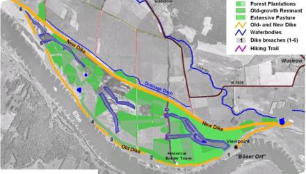
Location of the project
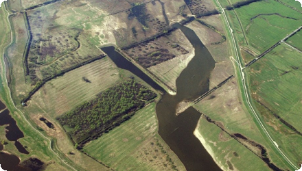
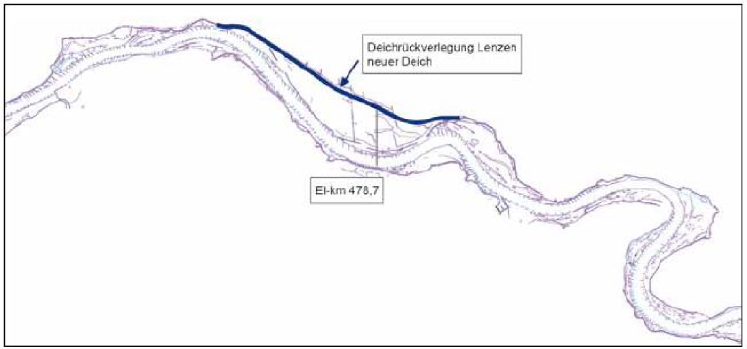
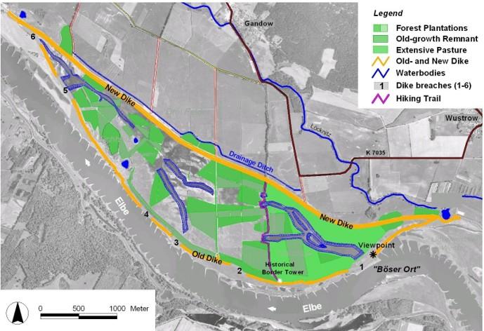
The measures are applied on a stretch of the Elbe river in Germany, next to Lenzen, between the Elbe kilometers 473.5 and 489.5.
NUTS Code
DE40 - Brandenburg
Project's objectives
Restore 420 ha of floodplain for retention and biodiversity
Reduce flood peaks on the Elbe River
Improve ecological connectivity and water quality
Support EU WFD and Natura 2000 objectives
Reduce flood peaks on the Elbe River
Improve ecological connectivity and water quality
Support EU WFD and Natura 2000 objectives
Involved Partners
| Authority type | Authority name | Role | Comments |
|---|---|---|---|
Climate zone
cool temperate dry
Temperature
9
Annual rainfall range
300 - 600 mm
Runoff
704
Runoff range
600 - 750 mm
Slope range
0-1%
Soil type
Fluvisol
Groundwater level
Shallow (<1.5 m)
Vegetation class
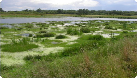
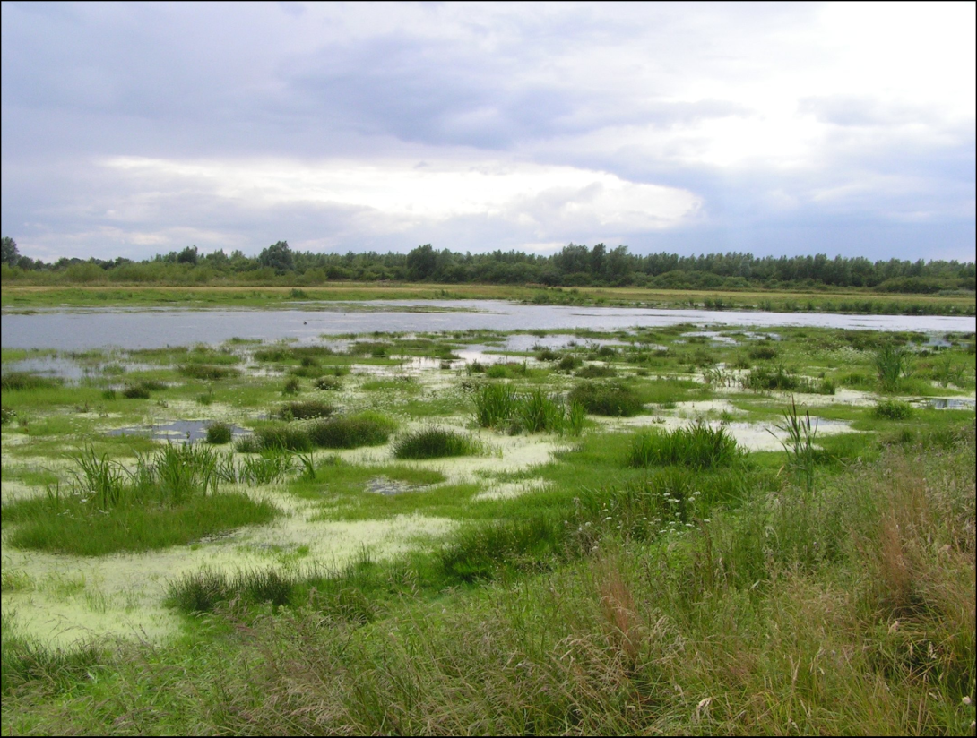
Prior to the project implementation, the area was subject to agricultural use. After implementation it was converted to alluvial forests and half-open pasture landscapes (Salix, Alnus, Carex).
Water bodies: Ecological Status
Moderate
Water bodies: Chemical Status
Failing to achieve good
Water quality status
Limited self-purification, channelization impacts, disconnected floodplain
Project scale
Meso
Project scale specification
Regional river floodplain restoration along 6.1 km of dyke. So far the biggest dyke relocation project in Germany.
Performance timescale
Immediate
Project area
1031
Area specifications
Area of reconnected floodplain.
Size
420
Size unit
ha
Lifespan
> 50 years
Consequent integration of nature conservation and flood protection objectives - as well as the sustainable use of the area through extensive agriculture.
Increasing public acceptance by providing a lot of information about the project.
Increasing public acceptance by providing a lot of information about the project.
Through the NWRM, 36% of a 20-25 years flood flow (3250 m3/sec) would take place in the newly created floodplain.
Design capacity description
The newly created retention area of 420 ha between the old dyke and the new one can comprise up to 16 million m3.
In times of extreme flood events the measure allows lowering the water level of up to 40 cm in the area.
In times of extreme flood events the measure allows lowering the water level of up to 40 cm in the area.
- In general, giving more space to water in floodplain areas (including through the relocation of dykes) is seen very positively in public discussions. Also the basic principle of taking both nature conservation and flood protection objectives into account influenced the choice of the measure.
- The dyke relocation became the central measure of the project, as it was only by this measure that the desired restoration of the floodplain to its original state and function could be achieved.
- Intensive research has taken place beforehand on the morphology and dynamics of the river Elbe (research project from 1996 to 2000). - Several alternatives had been examined, models have been elaborated.
- Alluvial forests had disappeared largely beyond the project area, and contributing to their recovery formed part of the project's objectives from the beginning.
- One alternative which would have led to a bigger retention area has not been retained, as depriving more areas from use wouldn’t have found public acceptance. Furthermore, problems with upward seed had been expected for this alternative.
No information on physical / biophysical constraints
Preconditions which led to the implementation of the measure were not natural, but mainly due to the fact that the old dyke had been constructed very close to the river bed. Alsot the topography : wide low-lying terrain with low slope
Total cost
€ 13,000,000
Costs total information
11.5 million euros for the construction of the new dyke (include 0.71 million euros for planning). 1.5 million euros for opening the old dyke (include 240 000 euros for planning).
Costs investment
€ 13,000,000
Costs investment information
11.5 million euros for the construction of the new dyke (include 0.71 million euros for planning). 1.5 million euros for opening the old dyke (include 240 000 euros for planning).
Costs operation maintenance information
n/a
Costs maintenance information
Maintenance costs exist for maintaining the dyke.
Economic costs, actual income loss
Actual income loss: In the newly created floodplain, agriculture has been abandoned on 444.5 ha. It has been replaced by a landscape conservation pasturing (half open pasture landscape).
Information on Economic costs other annual
Hunting rights have been limited in the area.
Information on Economic costs - income loss
Agricultural activities have been abandoned, but which were (after the German reunification) anyway not very adapted to the new market situation.
Financing authorities
Type of funding
National funds
Comments
Restoration funding
Type of funding
Sub-national funds
Comments
Co-financing
Type of funding
Private funds
Comments
NGO - Coordination, co-funding
Compensations
1
Compensations nr beneficiaries information
Land in the newly created floodplain only belonged to two farmers.
Compensations scheme information
Compensation payments have been made for the abandonment of agricultural areas, for the herewith induced operating adaptations of the farming activity, the dissolution of current land tenures and the land use difficulties of furthermore cultivated areas.
Policy context
The Elbe is regularly subject to (extreme) flood events, and first reflections on dyke relocation in the North of Lenzen were made some decades ago. But only after the German reunification did the discussion become more dynamic. Flood protection (in Germany) is based today on three pillars: Natural water retention, technical flood protection and flood prevention. In specific evaluations and in the public discussion, retention of water in the landscape, and here in particular in the floodplains and retention areas, receives high importance.
With the Elbe being also an important water way, acceptable measures required an intensive cooperation between different institutions: integration of ecological, flood protection and navigation objectives.
With the Elbe being also an important water way, acceptable measures required an intensive cooperation between different institutions: integration of ecological, flood protection and navigation objectives.
Land ownership
Mixed: private agricultural land and public land. Acquisitions and long-term agreements were negotiated.
Community involvment
Yes
Design consultation activity
| Activity stage | Name | Key issues | Comments |
|---|---|---|---|
|
Implementation phase
|
Guided tours
|
Guided tours take place in the project area.
|
|
|
Implementation phase
|
Visitor centre
|
A visitor centre informs about the project.
|
Policy target
| Target purpose |
|---|
|
Peak-flow reduction
|
|
Runoff control
|
|
Improved Biodiversity
|
|
Pollutants Removal
|
Target Remarks
- Re-creation of a near nature floodplain landscape, formed by the dynamic processes of streaming water
- Establishment of alluvial forests on former grassland through scattered, small-area initial plantings as well as development and maintenance of a floodplain typical mosaic of habitats with the associated species (e.g. hard- and softwood forests)
- Preservation of the groundwater dynamic which is characteristic for a floodplain and the corresponding soil types
- Development of half-open pasture and meadow landscapes
(periodically inundated grassland))
- Removal of a hydraulic bottleneck and the associated narrowing of the flood water flow bed
Policy pressure
| Pressure directive | Relevant pressure |
|---|
Pressures remarks
River channelisation.
Disconnected floodplain.
Agricultural use.
Disconnected floodplain.
Agricultural use.
Policy impact
| Impact directive | Relevant impact |
|---|
Impact remarks
High flood risk before the project
Loss of biodiversity and ecosystem functions
Loss of biodiversity and ecosystem functions
Requirement directive
| Requirement directive | Specification |
|---|
Requirement directive remarks
Compensation for land use change
Long-term maintenance agreements
Long-term maintenance agreements
Policy challenges requirements
The project was integrated in the restoration of the flood protection dykes in the German Federal State of Brandenburg. It has been initiated by the biosphere reserve "Flusslandschaft Elbe-Brandenburg", with the aim to recreate in particular alluvial forests. Furthermore, the manager of a large farm was at the origin of the discussions and further promoted the whole project with the idea to diversify his activities and embed them in a sustainable regional development strategy.
Contractual arrangements
1
| Arrangement type | Responsibility | Role | Name | Comments |
|---|---|---|---|---|
|
Contractual agreement
|
Land use & maintenance agreement
|
Agreement with farmers
|
Part of wider plan
1
Wider plan type
| Wider plan type | Wider plan focus | Name | Comments |
|---|---|---|---|
|
National
|
Environment & Biodiversity
|
Blaues Band Deutschland
|
Nature-based river restoration
|
Hydrological stations, biodiversity surveys
The following aspects are monitored (Damm et al. 2011):
- Hydrology: 12 groundwater gauges are supervised by the association carrying the project
- Hydraulics: Construction of 4 dyke gauges through the large-scale nature conservation project, steady reading of the meter by the state office, analysis through the Federal Waterways Engineering and Research Institute
- Soils: Two permanent observation plots of the Land Brandenburg, complemented by an evaluation at the end of the project
- Forestry: Examination of the planted alluvial forests in 2009 (evaluation)
- Fishes: Examination of the flood channels in 2009 and 2010, in time intervals further observations in cooperation with research institutes
- Birds: Examination in the framework of the evaluation of the project continuously 2007-2010, continued by the state of Brandenburg
- Vegetation: surveys through cooperation between the project management association, the state of Brandenburg and different research institutes
Maintenance
Periodic dyke inspections & vegetation management led by local water board & Biosphärenreservat.
Catchment outlet
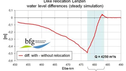
Substantial modeling exercises and numerical calculations had been undertaken to predict the effect on flood peaks. A two-dimensional, hydro-dynamic numerical model has been used (it compares the previous situation without dyke relocation with the one with dyke relocation).
The impact of the measures with regards to flood protection could be directly observed during the extreme flood event in January 2011.
The impact of the measures with regards to flood protection could be directly observed during the extreme flood event in January 2011.
Benefits of the project have not been specifically analysed. However, the following ones can be identified: - Flood protection (water retention)
- Benefits for the regional development: The project area got quickly established as a regional attraction on the international Elbe bike trail. In connection with a centre for environmental education and a visitor centre for the area a sustainable increase of the number of visitors occurred.
- During the construction period there had been some socio-economic effects in terms of employment and local consumption.
Benefits for the regional development: The project area got quickly established as a regional attraction on the international Elbe bike trail. In connection with a centre for environmental education and a visitor centre for the area a sustainable increase of the number of visitors occurred.
Furthermore, during the construction period, there had been some socio-economic effects in terms of employment and local consumption.
Furthermore, during the construction period, there had been some socio-economic effects in terms of employment and local consumption.
Retained water
16
Retained water unit
mio m3/month
Information on retained water
16 million m3 of water can be retained by the new floodplain area in case of flood events.
Increased water storage
38095
Increased water storage unit
m3/ha
Information on increased water storage
In terms of flood events, up to 16 million m3 can be retained in the 420 ha of the newly created floodplain area.
Peak flow rate reduction
36
Peak flow rate reduction unit
%
Information on Peak flow rate reduction
In times of extreme flood events (ocurring every 20-25 years), 36% of the flood flow is taking place in the floodplain.
Information on Increased groundwater level
Problems with upward seed are mentioned in the area next to the relocated dyke.
Reducing flood risks quantity change
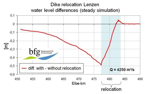
The reduction of (extreme) flood peaks is locally between 25 to 35 cm, depending on the flood flow rate.
Information on Ecosystem flood control volume
The created floodplain is limited by a (relocated) dyke - no separation of the effects is possible.
Information on Ecosystem flood control return periods
Effects with regards to the following flood events have been calculated:
a) Flood events recurring every 1-2 years = 1500 m3/s → 8.6 % of the flow in the new floodplain, water level reduction of 9.2 cm
b) Flood events recurring every 3-5 years = 2300 m3/s → 27.5 % of the flow in the new floodplain, water level reduction of 28 cm
c) Flood events recurring every 20-25 years = 3250 m3/s → 36 % of the flow in the new floodplain, water level reduction of 38.9 cm
Information on Increased landscape storage capacity
Water level reduction of 40–50 cm locally, up to 10 cm reduction upstream at Wittenberge.
Ecosystem erosion control
Improved sediment retention.
Water quality overall improvements
Positive impact-WQ improvement
Information on Water quality overall improvements
An effect on water quality is assumed through the retention of nitrogen and phophorous in the floodplain. Natural filtration processes were restored.
Information on Water quality Improvements (P)
Retention of P is assumed, no measurements took place.
Information on Water quality Improvements (N)
Retention of N is assumed, no measurements took place.
Soil quality overall soil improvements
Not relevant for this application
Information on Soil quality overall soil improvements
With regards to the impact of the measure, it is not about the quality of the soil, but its change back to its alluvial character.
1
Alluvial forests have been initiated by planting respective tree species. Furthermore, an half-open pasture landscape is maintained. An impact has been stated amongst others with regards to the development of a diverse avifauna.
Ecosystem impact climate regulation
No information available
Ecosystem provisioning services
1
Information on Ecosystem provisioning services
Agricultural activities have been abandoned. No information on other potential provisioning services.
Key lessons
The project shows a successful combination of nature conservation, flood protection and other objectives (agricultural, regional development, and others).
It is said that public communication activities should have been made in a more intensive way, in particular at the beginning of the project.
From an ecological perspective, an earlier / deeper connection to the Elbe would have been better to improve the lateral connectivity and morphological dynamic of the river. The latter would have also helped to minimize sedimentation processes in the new floodplain area, which can be expected in the middle and long term.
The highest effect of the measure can be stated next to the first opening of the dyke (on the "evil place") and it decreases towards the downstream part of the dyke relocation. Further downstream from the dyke relocation, the measure does not have any effect anymore on the water level. Upstream, the positive effect diminishes with an increasing distance. This shows that the measure has a very clear, but mainly regionally working impact. In order to solve the important flood problems of the Elbe river, it is indispensible to carry out other dyke relocation measures.
The measures are suitable to be applied also elsewhere. However, areas free of settlement are needed.
The continuous persuasion works from a few - and over several years - is highlighted as one key factor for the successful implementation of the project. The prior implementation of research projects ensured the effectiveness of the measure design, but was also very useful for providing support for public discussion.
Success factor(s)
| Success factor type | Success factor role | Comments | Order |
|---|---|---|---|
|
Attitude of relevant stakeholders
|
main factor
|
Early involvement of farmers was crucial and positive. |
|
|
Financing possibilities
|
secondary factor
|
Access to various funding sources secured the feasability of the project. |
Driver
| Driver type | Driver role | Comments | Order |
|---|---|---|---|
|
Organisation committed to it
|
main driver
|
It was only due to the continued commitment of local stakeholders that the project could be implemented.
|
1
|
|
Past flooding events
|
main driver
|
Reducing the local flood risk was a main driver for the implementation of the measures. The 2002 event reveales need for better retention.
|
2
|
|
Legal obligations
|
main driver
|
There had been legal obligations to adjust the old dyke to current requirements - which temporarily coincided with the development of the project idea.
|
3
|
Transferability
The preconditions in terms of stakeholder engagement were quite particular - going back to changes in the framework of the political turnover in Germany. However, from a technical point of view, dyke relocations can be implemented in any other area were sufficient settlement free areas exist. High transfer potential in lowland floodplains; replicable if space and stakeholder support exist.
Basin characteristics influence
Relocating the dyke near the Elbe’s sharp bend at “Böser Ort” created a key water retention area, reducing the river corridor from 1200 m to under 500 m and improving flood management.
Cost effectiveness
High: multiple ecosystem services for relatively low cost; cost lower than flood defence-only options.
Source(s)
English