Last update
2025
Summary
This scheme is part of the long-term SigmaPlan in Flanders, designed to increase flood storage in the Scheldt catchment while restoring natural habitats. On the Grote Nete, the project reconnects the river with its floodplain, previously cut off by dykes. In the middle reach, controlled flood storage areas (GOGs) are being developed, while in the upper and lower reaches free connections are restored, creating opportunities for wetlands, grasslands, and riparian forests.
Since 2015, planning has advanced through a spatial implementation plan (GRUP) and a subdivision into three sub-areas: Zammelsbroek, Tussen Hellebrug en Herenbossen, and Ter Borght–De Merode. Works are ongoing in Zammelsbroek and Hellebrug–Herenbossen, with dike modifications, creation of winter beds, reconnection of tributaries, and restoration of wetlands. The Ter Borght–De Merode section is progressing administratively, with environmental procedures under way. By 2024–2025, public information points and guided visits confirmed the transition to implementation on site.
The project is managed by De Vlaamse Waterweg nv and the Agency for Nature and Forest (ANB), within the broader valley programme “Het Grote Net(e)werk” led by the Province of Antwerp. This coalition aligns flood protection, water quality, and ecological objectives across about 900 ha along 30 km of river. Funding is supported by the SigmaPlan and the Flemish Blue Deal (2025–2029). Implementation requires addressing sediment and water quality constraints but is expected to deliver multiple benefits: improved flood safety, reconnected habitats, and increased resilience of the Grote Nete valley.
Position
Latitude
51.05243
Longitude
4.44343
Project
NWRM
National Id
Belgium_02
Installation date
2005-2012
Implementation Status
Contact
Heather Williams and Chris Binje, AMEC
RBD code
BESchelde_VL
Transboundary
0
Photo gallery
Location of the project
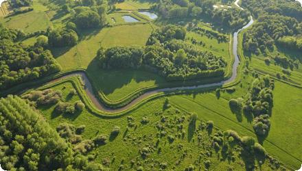
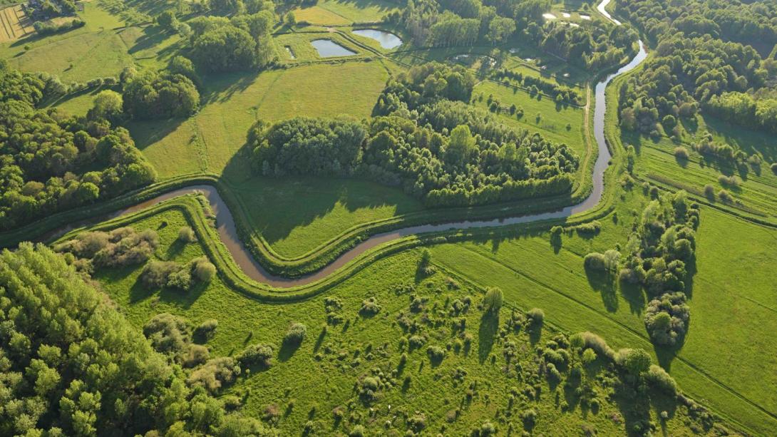
The measure is located along the floodplain of the Grote Nete, between the towns of Oosterlo and Nijlen, in northern Belgium.
NUTS Code
BE21 - Prov. Antwerpen
Project's objectives
Increase storage from 6.6 to 8.4 Mm³; create ~850 ha of wet nature; re-establish river–floodplain connectivity (free upstream/downstream; controlled in mid-reaches). Land acquisition of ~650 ha anticipated in early plan phase.
Involved Partners
| Authority type | Authority name | Role | Comments |
|---|---|---|---|
Climate zone
cool temperate moist
Temperature
10.9°C
Precipitation
800
Elevation range
5 m
Vegetation class
Valley wetlands: extensive marsh and reedbeds, wet meadows, willow scrub; alluvial alder–ash forests (Habitat 91E0) and open-water/pond mosaics (notably in Zammelsbroek).
Water bodies: Ecological Status
Bad
Water bodies: Chemical Status
Failing to achieve good
Water quality status
Legacy heavy metals (As, Cd, Hg, Co) in sediments/dykes; radiological legacy (Grote Laak: radium; Molse Nete: americium/polonium); nutrient loads; past channelisation/dykes degrade hydromorphology.
Project scale
Large
Project scale specification
A river-valley project across multiple municipalities, combining controlled flood areas and free reconnection measures at sub-basin scale.
Performance timescale
Immediate
Project area
1,700 ha
Area subject to Land use change or Management/Practice change (ha)
898 hectares and over 30 kilometers of river
Size
898
Size unit
ha
Lifespan
not limited
Multifunctionality: flood-safety + nature restoration. Measures include floodplain reconnection (free & controlled GOGs), dike lowering/removal, winter bed creation, reconnection of tributaries, and wetland/forest restoration.
Design capacity description
Increases the storage capacity in the river valley from 6.6 million m3 to 8.4 million m3.
The implementation of restoration measures in the Grote Nete valley is constrained by factors such as altered hydrology from past drainage systems, specific soil and water conditions required for target habitats, flat topography that affects water flow, past land use impacts, and seasonal weather patterns that influence the timing and effectiveness of restoration works.
Only very limited development in the concerned area.
The areas to be included were originally the floodplain of the Grote Nete, so are well suited to restoration to their original purpose
Flat Kempen sand valley with river-dune features favours space for water; widespread historic dykes/drainage and mixed ownership complicate works; contaminated sediments/radiological legacy require strict controls during earthworks.
Total cost
€24.5 million
Costs total information
An early estimate put the Oosterlo–Itegem reconfiguration at 2005 prices. Cost includes costs for infrustructural changes and land purchase.
SigmaPlan was ~€1.5 billion (2020 estimate).
SigmaPlan was ~€1.5 billion (2020 estimate).
Costs operation maintenance information
The measure will reduce the recurring costs for dyke maintenance, but the cost for nature conservation will rise.
Economic costs, income loss
2000
Economic costs income loss unit
€/ha
Information on Economic costs - income loss
The overall Sigmaplan foresees in a compensation of 2000 euros per ha for land users directly affected by the measures and compensation of 1000 euros per ha for land users not directly affected by the measure but who voluntarily make their lands available within the framework of the NWRM (for example as part of land exchange schemes with directly affected farmers). The land owners will get an allowance of atleast 20%. When the land owner and land user are the same, both compensations can be cumulated.
Financing authorities
Type of funding
Sub-national funds
Comments
Funds provided by the Flemish government.
Compensations
1
Compensations scheme information
The accompanying agricultural support measures are set under the framework of the Sigmaplan: - Support with identifying of exchange lands or company relocations
- Extra time to transform the company by phasing the works
- Border corrections to assure the liveability of companies by for example excluding lots with construction - Appealing retirement scheme
- Financial support for changing land-use from arable to pasture
- Extra time to transform the company by phasing the works
- Border corrections to assure the liveability of companies by for example excluding lots with construction - Appealing retirement scheme
- Financial support for changing land-use from arable to pasture
Policy context
This project aims at the large-scale restoration, development, and sustainable management of alluvial forests (90%), primarily through natural reforestation, as well as smaller areas comprising high-value open habitats (10%). Within SigmaPlan (flood protection + ecosystem restoration). Spatial planning via GRUP (Startnota 17 Dec 2021; public consultation Jan–Mar 2022). Delivery led by De Vlaamse Waterweg & ANB, embedded in the Province of Antwerp’s strategic project “Het Grote Net(e)werk”. Core problem: high flood risk + degraded river–floodplain habitats; obligations under WFD/Natura 2000.
Land ownership
Mixed tenure: Flemish public bodies (ANB & De Vlaamse Waterweg) own/manage key parcels; NGO Natuurpunt holds reserves. Many plots remain private : ANB is acquiring remaining private lands in Zammelsbroek.
Community involvment
No
Design consultation activity
| Activity stage | Name | Key issues | Comments |
|---|---|---|---|
|
Design phase
|
Meetings during planning phase
|
Meetings have been organized with all interested parties, including information provided through local city halls.
|
|
|
Implementation phase
|
Newsletters for residents
|
Regular newsletters have been made to inform interested parties of the progress of the project.
|
|
|
Implementation phase
|
Comprehensive website
|
On the website detailed animated videos can be found about what is going to happen including reasons for actions taken.
|
|
|
Implementation phase
|
Individual consultation with landowners
|
Individual consultation is held with each landowner to develop the best solutions
|
Policy target
| Target purpose |
|---|
|
Increase Water Storage
|
|
Improved Biodiversity
|
Target Remarks
Main targeted problem is the high flood risk in the area.
Policy pressure
| Pressure directive | Relevant pressure |
|---|
Policy impact
| Impact directive | Relevant impact |
|---|
Requirement directive
| Requirement directive | Specification |
|---|
Contractual arrangements
0
| Arrangement type | Responsibility | Role | Name | Comments |
|---|
Part of wider plan
1
Wider plan type
| Wider plan type | Wider plan focus | Name | Comments |
|---|---|---|---|
|
Catchment-based
|
Water
|
SigmaPlan
|
The SigmaPlan is a catchmentbased program for the river Scheldt. It was initially intended to mitigate the problems for tidal related floodings, but has since evolved to also include overall water safety measures.
|
Laboratory
The scheme performance has been modelled.
The social benefit of obtaining a self-maintaining estuary of the Scheldt and reducing flood risk.
Social benefit of creation of a natural area of a significant size (recreational value) ; indirect positive outcome to the economy through creation of recreation opportunities. Tourism is promoted in the area.
Hydrological effects
The project reconnects floodplains, slows water flow, boosts infiltration, and filters pollutants—reducing floods, improving water retention, and enhancing water quality.
Information on retained water
The retention capacity of the floodplain will be 8.4 million m3.
Information on increased water storage
The retention capacity of the floodplain was previously 6.6 million m3, so the implementation of the scheme represents an increase of 1.8 million m3.
Runoff reduction
27
Runoff reduction unit
% Percent
Information on runoff reduction
Predicted by hydraulic modelling.
Ecosystem erosion control impact unit
% reduction
Water quality overall improvements
Neutral impact-no change in WQ status
Information on Water quality overall improvements
This has not been considered in detail in the study, although some effects on water quality may be expected through the creation of wetland habitat, in relation to sediment deposition and pollutant retention.
Soil quality overall soil improvements
Neutral impact-no change in SQ status
Information on Soil quality overall soil improvements
The lands that will be made accessible to the water in the future have a higher probability of being influenced by pollutant deposition from the river. However, this has not been quantified.
1
Yes, new wetlands will be created on formerly agricultural land. Vegetation will change, with associated changes to soil and habitats for plants and animals
Ecosystem impact climate regulation
No information available
Ecosystem provisioning services
1
Information on Ecosystem provisioning services
The controlled storage areas are expected to have a flood frequency of 1 in 5 years, with agriculture use still being continued the rest of the time. At locations where nature will be developed, farmers will be given land elsewhere in the valley as a compensation measure.
Key lessons
Integration of the project under the larger Sigmaplan enabled the project communication to go smoother and inter-agency communication was already established through the overarching plan.
Allowing long timescales is important and allows for the optimal outcome to be achieved, by allowing landowners greater flexibility.
Allowing long timescales is important and allows for the optimal outcome to be achieved, by allowing landowners greater flexibility.
Success factor(s)
| Success factor type | Success factor role | Comments | Order |
|---|---|---|---|
|
Successful coordination between authorities
|
main factor
|
<p>As this project is part of the Sigmaplan, overarching consulting pre-existed prior to the project within the sectoral consultation bodies (agriculture, nature, government, ...). This enabled to get all local stakeholders involved as well in an early phase to successfully coordinate any issues during the design phase.</p>
|
1
|
|
Conducted assessments (incl. economic)
|
main factor
|
<p>Although time consuming, the preceding studywork (reports regarding effects on agriculture and nature development, details of ground- and surface waters, ...) lead to a complete development plan which enhanced coordination greatly.</p>
|
2
|
|
Specific incentives for stakeholder involvement
|
main factor
|
<p>The Sigmaplan has a comprehensive approach to consulting with stakeholders and finding solutions to allow the measures to progress on their land</p>
|
3
|
Driver
| Driver type | Driver role | Comments | Order |
|---|---|---|---|
|
Past flooding events
|
main driver
|
Re-evaluation of flood risks (including expected climate change)
|
1
|
|
Other
|
secondary driver
|
Reinstatement of the estuary of the Scheldt as a self-sustaining ecosystem
|
2
|
Transferability
The restoration measures used in the Grote Nete valley are transferable to other lowland river systems with similar conditions, such as altered watercourses, degraded wetlands, and historical land use pressures.
English