Last update
2025
Summary
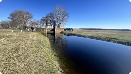
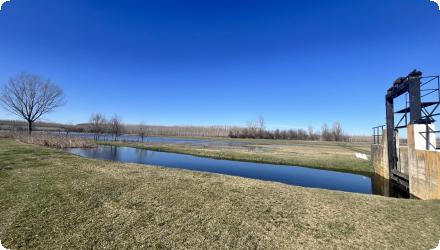
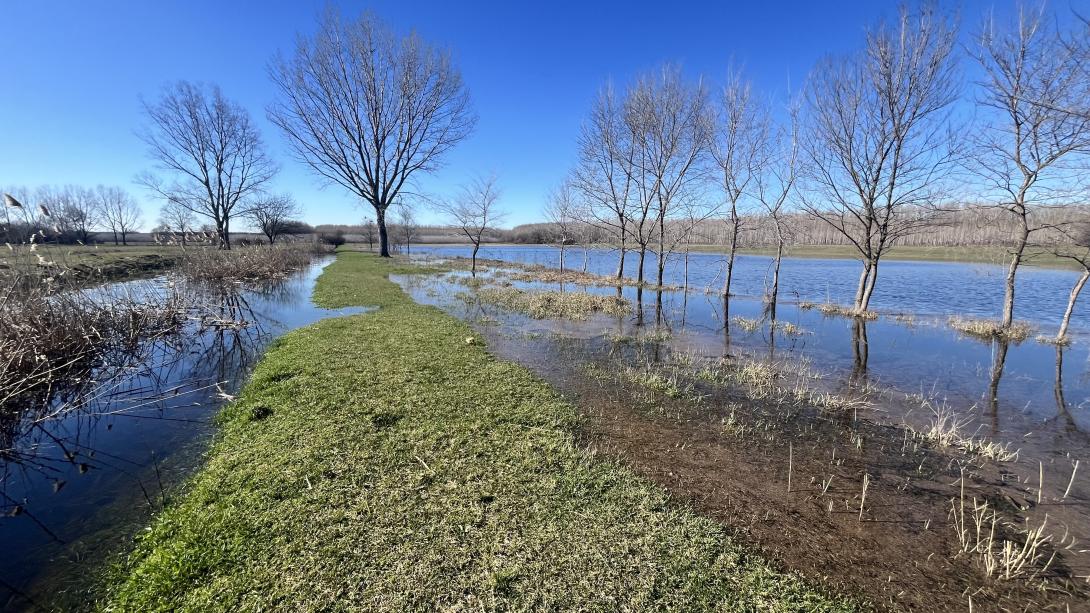
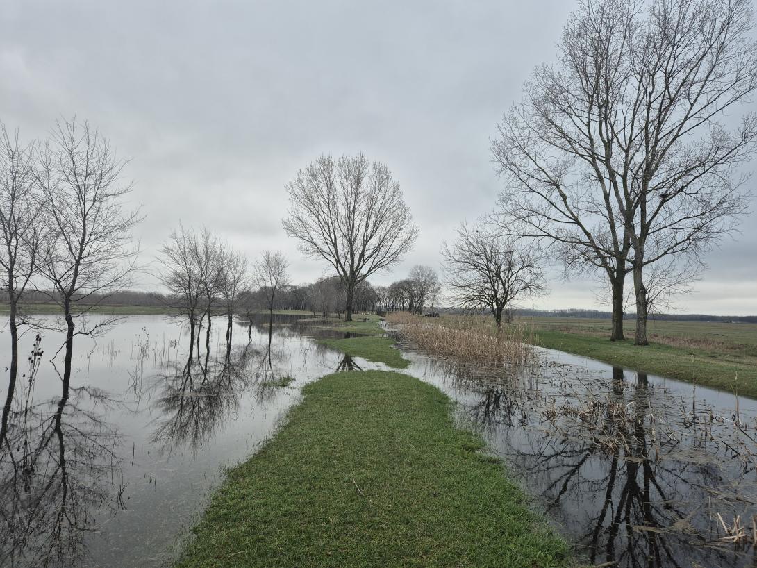
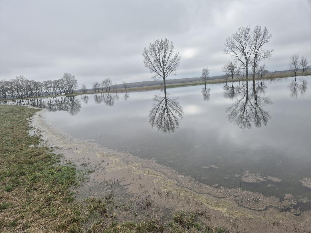
The fragments of floodplain forests (Fraxino - pannonicae -Ulmetum) along the River Körös were cut from the river by dykes during the river regulation works in the 19th century. The deteriorated groundwater conditions were worsened in a drought period during the 1980-1990’s that triggered action of the forestry service. Restoration of the river connection and the floodplain watercourse network provide surface water supply from the backwater of flood waves to the 2000 ha forest. The result of the habitat reconstruction work is a 38.8 km long water-flow and a water surface of 15.7 hectares, cc 400 hectares of the forest has a direct positive ecological impact.
The water supply of the floodplain channel network has another source as well. A smaller volume comes from a fishery. In case of this second source the nutrient content of the fishery is assimilated in the forest as an additional service. Previously this load were let back into the river directly.
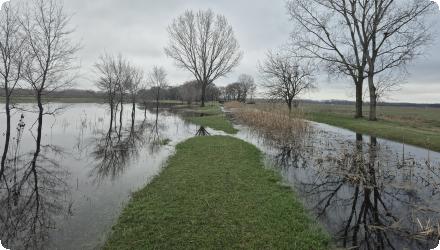
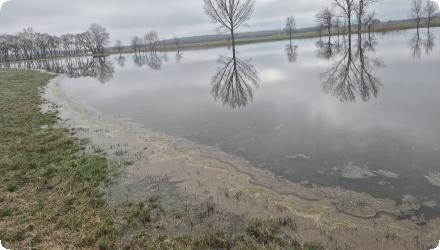
Due to the particularly dry recent years, there has been an increase in the tendency to retain water in the watershed. Landowners have voluntarily offered areas designated for periodic flooding in order to mitigate the damage caused by drought during summer periods. Due to the water shortages, the use of water retention options has become more valuable. For this reason, in 2025 temporary storage is carried out at two locations along the canal.
The water supply of the floodplain channel network has another source as well. A smaller volume comes from a fishery. In case of this second source the nutrient content of the fishery is assimilated in the forest as an additional service. Previously this load were let back into the river directly.
Due to the particularly dry recent years, there has been an increase in the tendency to retain water in the watershed. Landowners have voluntarily offered areas designated for periodic flooding in order to mitigate the damage caused by drought during summer periods. Due to the water shortages, the use of water retention options has become more valuable. For this reason, in 2025 temporary storage is carried out at two locations along the canal.
Position
Latitude
46.698664
Longitude
21.389736
Project
NWRM
National Id
Hungary_01
Installation date
1999-2011
Contact
Gábor Ungvári, REKK
RBD code
HU1000
Transboundary
0
Photo gallery

NUTS Code
HU33 - Dél-Alföld
Project's objectives
Regulation of hydrological cycle and water flow.
Regulation of the chemical status of freshwater.
Enhance infiltration into the soil at the detention ponds to recharge subsurface resources.
Regulation of the chemical status of freshwater.
Enhance infiltration into the soil at the detention ponds to recharge subsurface resources.
Involved Partners
| Authority type | Authority name | Role | Comments |
|---|---|---|---|
Climate zone
warm temperate dry
Temperature
12
Precipitation
550
Annual rainfall range
300 - 600 mm
Runoff
34,6
Runoff coefficient
0.2-0.3
Runoff range
0 - 150 mm
Evapotranspiration
800
Elevation range
98
Slope range
0-1%
Vegetation class
Broad-leaved forest
Water bodies: Ecological Status
Moderate
Water bodies: Chemical Status
Failing to achieve good
Water quality status
Significant nutrient load from a point source polluter : sewage treatment plan of a food processing plant. There is no risk of priority substances. pH is 8.04-8.34. Salinity is medium.
Project scale
Large
Project scale specification
Size of the Körös stream catchment is 481 km2. The length of the water course is 40 km.
Performance timescale
Immediate
Project area
5 ha at the estuary
Area specifications
The application intends to control surface flows of the 480 km2 catchment. At a recent stage of the development, with 5 hectares restored, there are temporarily flooding areas at the estuary.
Area subject to Land use change or Management/Practice change (ha)
40
Size
38,7999992370605
Size unit
km
Lifespan
33
Planning principles from the feasibility study are:
Keep in mind the social rationality of protection against water logging in areas where drainage cost more than the yield of farming the land use change should promote.
Surplus water that pose threat to life and property must be drained. Residential and agricultural water management must be harmonized and surface water runoff must be reduced by retention and storage.
Conditions that are necessary to reach the good ecological status of water must be provided, especially for the quality of the retained water.
The volume of the detention pond above the town is 50-60 thousand m3. The retention capacity at the estuary is 50 thousand m3. The retention and assimilation capacity of the connected meadows are aproximately 93 ha, and 650 thousand m3.
Design capacity description
Maximum quantity of water derived from the river depends on the water level. During a year there is cc 180 days for water supply. During this period cc 2 million m3 water arrives into the area
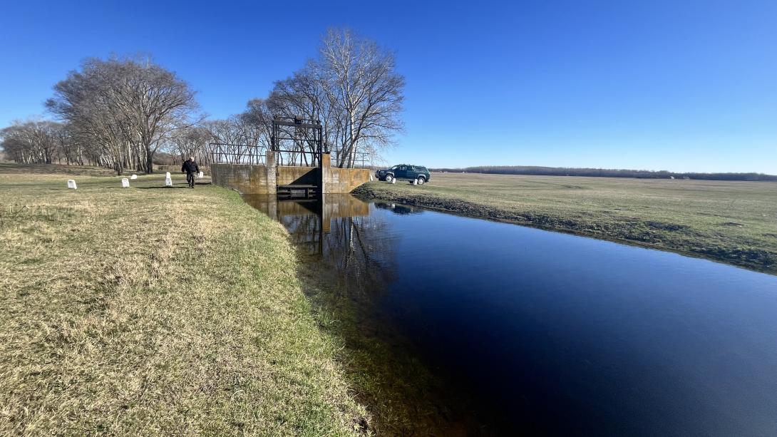
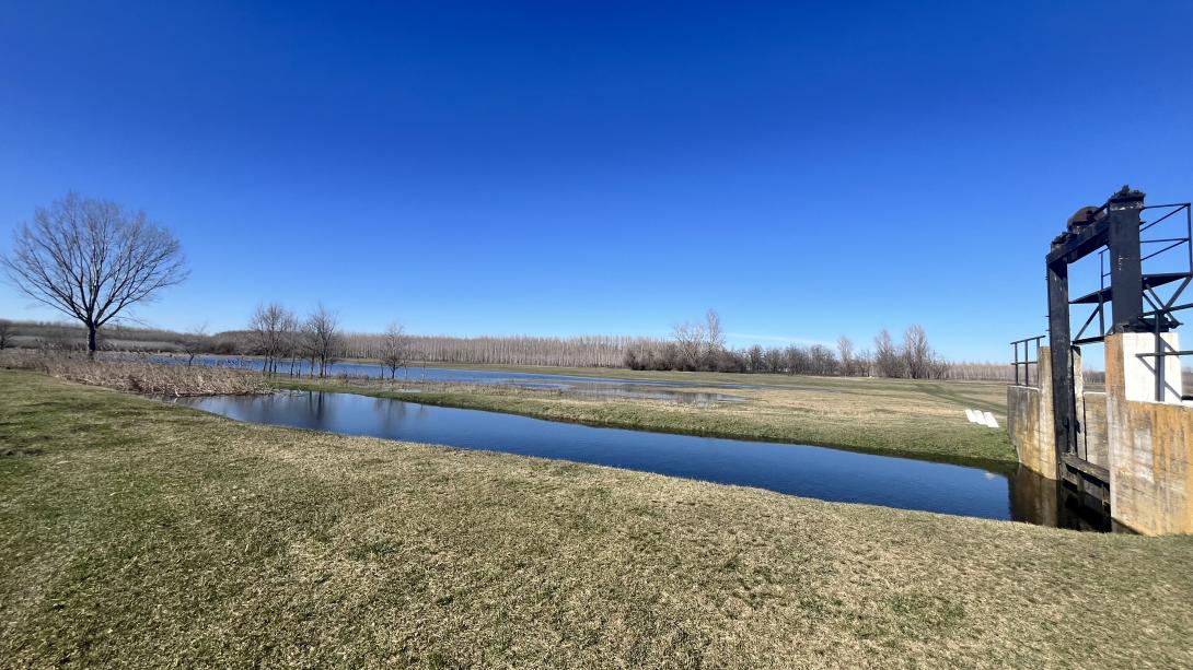
Detention pond and online storage capacities were introduced upstream of the settlement in order to slow control runoff and to provide surplus water at low water periods to prevent water quality problems (of high pollutant concentration) downstream. This was the solution that required only public land along the water course.
The high cost of a previous attempt to pump water for the area proved prohibitively expensive and made it clear that only gravitational supply can provide sustainable solution.
This is a state owned forest, that consists of one forest body. Also it is inside a temporary flood storage reservoir in a band of the River Fekete-Körös. The isolation of the area and lack of the risk of flooding further areas made it an easy case from the water directorate's point of view
The landscape relief that has the former river branches in the territory
The landscape relief that has the former river branches in the territory
Positive influence effectiveness
Upstream from the settlement there is interest for recreational use of the stored water
Negative influence effectiveness
Spanning accross different regions delayed the project.
Total cost
€ 3,667,000
Costs total information
The calculations assumed 5% discount rate for the 30 year period of the project. The HUF-EURO exchange was calculated on 2008 € average exchange rate.
Costs investment
810000
Costs investment information
Planner's estimation of the development cost in 2014 prices of the same work volume, 200-300 million HUF (650.000 - 970.000€)
Costs capital
€ 3,730,000
Costs capital information
It is higher than the total because project calculations include the estimated cost reduction in operational costs.
Costs land acquisition
€ 145,000
Costs operational information
There are cost savings due to forgone pumping cost 88.800€
Costs operation maintenance information
No significant operation or maintenance cost were identified
Costs maintenance
€ 25,400
Costs maintenance information
The Net Present Value of total maintenance cost € 57,100, but there is a forgone cost of desludging € 31,700.
Financing authorities
Type of funding
National funds
Comments
Reorganization subsidy from the owner the (state owned) National Privatization and Asset Management Ltd. (Regional Forestry Organizations were formed into state owned joint stock companies.
Transfer from the (that time existed) national Forest Regeneration Fund
Transfer from the (that time existed) national Forest Regeneration Fund
Type of funding
EU-funds: Rural development funds
Comments
EU Regional Development Fund KMOP-3.3.1/C-2008-0003
Compensations
0
Policy context
River regulation works of the 19th and 20th century resulted in degraded living conditions for the river valley forests (declining groundwater levels, lack of inundations). A 12 year long dry period in the 1980-1990 pushed the remaining forests into critical status. The insufficient available water quantity had to increase.
Land ownership
The areas that are necessary for the development of the structures belong to public ownership. Along the middle section of the stream there are privately owned agricultural lands.
Community involvment
Yes
Design consultation activity
| Activity stage | Name | Key issues | Comments |
|---|---|---|---|
|
Design phase
|
There were consultation with the private land owners of the area
|
There were no details provided
|
Policy target
| Target purpose |
|---|
|
Groundwater Recharge
|
|
Increase Water Storage
|
Policy pressure
| Pressure directive | Relevant pressure |
|---|---|
|
WFD identified pressure
|
4.1.2 Physical alteration of channel/bed/riparian area/shore of water body for agriculture
|
|
WFD identified pressure
|
1.3 Point - IED plants
|
|
Floods Directive identified pressure
|
Other FD pressure: water logging on agricultural land and urban sites
|
Policy impact
| Impact directive | Relevant impact |
|---|---|
|
WFD identified impact
|
Nutrient pollution
|
|
WFD identified impact
|
Altered habitat due to hydrological changes
|
|
WFD identified impact
|
Altered habitat due to morphological changes
|
Requirement directive
| Requirement directive | Specification |
|---|---|
|
WFD-achievement of good chemical status
|
High nutrient and salinity level, dissolved oxygen status medium, not fulfills the requirements of good potential.
|
|
WFD-achievement of good ecological status
|
Hydro-morphological status. No zoning, lack of morphological variability along the water course.
|
Requirement directive remarks
In the WFD categorization the stream is designated as heavily modified water body, the goal is good ecological potential
Policy challenges requirements
This area is part of the highly concerned region of The National Droughts Strategy Text
Contractual arrangements
0
| Arrangement type | Responsibility | Role | Name | Comments |
|---|
Part of wider plan
0
Wider plan type
| Wider plan type | Wider plan focus | Name | Comments |
|---|
There is a qualification of the water body by the WFD components every year: Oxygen status, organic materials; nutrient load; acidity; salination, also priority substances. The biomonitoring includes: fitoplankton, Macrofita, macrozoobenton, fish fauna. Chemical parameters and fitoplankton are collected on monthly bases, the other annual bases. There are three sample point above the settlement, below the discharge point and at the estuary
Maintenance
Half sided maintenance works along the stream to keep clean the peak flow cross section and provide the necessary zoning.
Unknown
The last WFD status assessment was carried out in 2015. The monitoring results are compared with the annual rating of monitoring results, which is published in the yearbook of the regional water management directorate.
There are lower defence costs at water logging periods because no pumping costs will be raised at the estuary lock where temporary storage area was created.
Amenity benefits in the settlement where a new 4 hectare park was created above the track of the culvert.
Amenity benefits in the settlement where a new 4 hectare park was created above the track of the culvert.
Biomass production.
Wildlife management, the area provides higher animal carrying capacity.
Assimilation of nutrient load of incoming water.
Wildlife management, the area provides higher animal carrying capacity.
Assimilation of nutrient load of incoming water.
Amenities: This area is the Forest School of the nearby Gyula town, education and recreation facilities for school programs with regional importance. Total education activity 3-4 thousand education day per year (counted like workload in the person month). 3-6 visitor nights.
Retained water
2000000
Retained water unit
m3/year
Information on increased water storage
Previously it was zero
Runoff reduction
50-60,000 m3
Information on runoff reduction
Runoff is attenuated by the detention pond upstream the settlement. The flow inside the settlement is controlled by the capacity increase of the crossing culvert.
Information on Peak flow rate reduction
Peak flow is reduced by the capacity of the detention pond. While on other parts of the catchment no runoff attenuation developments were made. The emphasis was given to the creation of storage areas.
Information on Increased infiltration
Measures impact on groundwater is positive, there are enhanced possibility of infiltration at the retention pond. The reason of applying a closed culvert (among other aspects) across the settlement was the protection of groundwater, because an open watercourse would drain the groundwater at low water periods.
Soil moisture
Only a very local effect.
Information on Reducing flood risks, quantity
Flood risk is managed with the upstream detention pond, the upgrade of the culvert across the settlement, the provision of the necessary drainage capacity of the stream and the creation of buffer zones at the estuary
Information on Restoring hydraulic connections
At the stream estuary 5 ha can be inundated. Along the 31km middle section there are places where protected areas are reconnected to get water at high water periods.
Water quality overall improvements
Positive impact-WQ improvement
Information on Water quality overall improvements
The forest assimilate the nutrient overloaded water from the near-by fishery. The detention pond above the settlement will serve as a reserve for dilution when water quality problems arise due to low water quantities in the stream. (The effluent of the town’s treatment plant discharges into the stream)
1
The upgrade of the lock at the estuary enable the fish migration between the Körös stream and the Tisza.
Ecosystem impact climate regulation
No information available
Ecosystem provisioning services
1
Key lessons
Surface water supply is an effective way of recharging groundwater storage capacity of forest soil in order to reduce droughts risk by enhancing the natural inter-seasonal allocation of water.
The key difference of this application compared to an area with generally the same problems is the possibility to sort out the transaction costs that emerge from in an area with multi-party ownership.
If the suitable complex knowledge happens to be at the right place, no further incentive is needed to take advantage of an upcoming possibility. †“ It highlights the fundamental need of education about the complex nature of the water-land use-ecosystem nexus.
Success factor(s)
| Success factor type | Success factor role | Comments | Order |
|---|---|---|---|
|
Attitude of relevant stakeholders
|
main factor
|
<p>The main success factor was the forestry management's unequivocal understanding of the structural problem what threatens the sustainable operation: the lack of inundations. They grasped the first occasion to finance and negotiate such a development. The financial consolidation/restructuring process of the state forestry organizations provided financial sources that were used to improve fundamental production conditions.</p>
|
1
|
Driver
| Driver type | Driver role | Comments | Order |
|---|---|---|---|
|
Organisation committed to it
|
main driver
|
Enabling factor was the initiative role of the water directorate and its co-operation with the national park to. The main enabling factor was the availability of funds that make possible to tackle problems that the settlement faced.
|
1
|
Flexibility adaptability
The implemented measures are flexible. From technical point of view it can service higher water retention needs and governing water to adjacent areas if the necessary land use agreements are set.
Cost effectiveness
The development was a mix of different type of measures. There is no possibility to compare by such dimensions.
English
management services of the area by law.
Details that belong to the design of the dyke crossing of the water supply channels. It also has role in the operation of the locks.