Last update
2025
Summary
The Lippenbroek project, launched in 2006 in Hamme (Belgium) as part of the Sigma Plan, implements an innovative sponge measure that combines flood protection with ecological restoration through a Controlled Reduced Tide (CRT) system. Established on a former 10-hectare polder, the site receives tidal water through regulated culverts, recreating an intertidal environment favorable to freshwater wetland habitats. The objectives were to store floodwaters, restore estuarine habitats, and test the CRT concept for future applications. The results have been highly positive: improved water quality, rapid vegetation development, increased biodiversity, and natural morphological evolution. The site’s success makes it a model for estuarine restoration in the Scheldt estuary.
In 2025, it remains very relevant as a demonstrator site, and still is a research area.
In 2025, it remains very relevant as a demonstrator site, and still is a research area.
Position
Latitude
51.085
Longitude
4.171
Project
NWRM
National Id
Belgium_02
Installation date
2006
Implementation Status
Contact
Elia Desmot, OIEau
RBD code
BEEscaut_Schelde_BR
Transboundary
0
Photo gallery
Location of the project
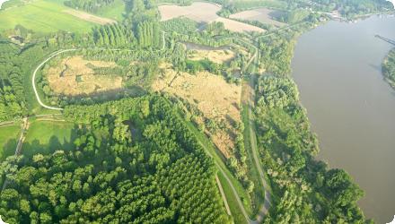
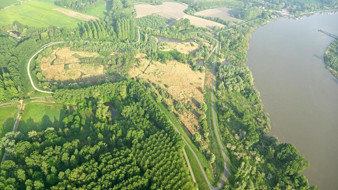
The site lies along the tidal section of the River Scheldt, just downstream from the confluence with the Dender River. it is situated within the floodplain of the Scheldt estuary.
Project's objectives
Research : does it work and can it be implemented on large scale to restore tidal nature in combination with flood safety.
Involved Partners
| Authority type | Authority name | Role | Comments |
|---|---|---|---|
Climate zone
cool temperate moist
Temperature
11 °C
Precipitation
800
Annual rainfall range
600 - 900 mm
Runoff
Average tidal volume: 25 000 m³
Elevation range
2 m
Slope range
Flat
Groundwater level
Compacted clay layer (former polder)
Vegetation class
Freshwater estuarine vegetation
Water bodies: Ecological Status
Bad
Water bodies: Chemical Status
Failing to achieve good
Water quality status
High N and P input. Pollutants (metals, PFAS, …)
Project scale
Meso
Project scale specification
While relatively small in size, its function as a pilot site for the Controlled Reduced Tide (CRT) system gives it strategic importance within the catchment-wide Sigma Plan for the Scheldt estuary.
Performance timescale
< 1 year
Area specifications
Small pilot site of 10 ha (as a pilot for about 2000 ha of this kind of nature restoration in the Schelde)
Size
10
Size unit
ha
Lifespan
100
Combination of flood defense and nature restoration: new concept of Flood Control Area with Controlled Reduced Tide.
The Lippenbroek measure primarily addresses tidal flooding rather than specific storm events like the 1-year or 2-year storm. The system is designed to manage tidal surges and extreme water levels associated with storms, using controlled tidal exchange to manage flood risks. It focuses more on long-term flood resilience and habitat restoration than on specific rainfall-based storm events.
Design capacity description
40 000 m3
Main constraint : Site’s elevation. Low elevation = large storage capacity
Scheme implementation was slowed by financial aspects and public opinion - consequently the project took a long time to materialise.
The scheme was made possible by a desire for integrated water management.
Financing authorities
Type of funding
National funds
Comments
The Lippenbroek project was financed by the Flemish government as part of the Sigma Plan for flood protection and ecological restoration in the Scheldt estuary. Additionally, funding came from EU financial mechanisms, supporting water management and environmental restoration projects across Europe.
Type of funding
EU-funds: Cohesion and regional development funds
Type of funding
National funds
Type of funding
National funds
Policy context
The Lippenbroek project serves as a demonstration site that tackles two major challenges: increasing flood risk in the Scheldt estuary due to climate change and sea level rise, and the severe loss of natural estuarine habitats from historical land reclamation and dike construction. These issues are linked to hydromorphological pressures identified under the EU Water Framework Directive. By implementing a Controlled Reduced Tide system, the project delivers improved flood defence while enabling habitat creation through the restoration of tidal wetland functions. This dual-purpose approach supports WFD objectives by reconnecting floodplains and enhancing ecological status in transitional waters.
Land ownership
Agency for Nature and forestry (Regional government)
Community involvment
No
Design consultation activity
| Activity stage | Name | Key issues | Comments |
|---|
Policy target
| Target purpose |
|---|
|
Peak-flow reduction
|
|
Improved Biodiversity
|
Policy pressure
| Pressure directive | Relevant pressure |
|---|---|
|
WFD identified pressure
|
Hydrological regime – flow regulation and morphological alterations
|
|
WFD identified pressure
|
Morphological conditions – river and floodplain disconnection
|
Pressures remarks
The Lippenbroek site reconnects former floodplains to tidal dynamics, and restores the natural tidal regime (altered by embankments, sluices, and water level control).
Policy impact
| Impact directive | Relevant impact |
|---|
Requirement directive
| Requirement directive | Specification |
|---|---|
|
WFD-achievement of good ecological status
|
|
|
Other EU
|
Natura 2000
|
Contractual arrangements
0
| Arrangement type | Responsibility | Role | Name | Comments |
|---|
Part of wider plan
1
Wider plan type
| Wider plan type | Wider plan focus | Name | Comments |
|---|---|---|---|
|
Regional
|
Water
|
Sigma Plan
|
The Sigma Plan focuses primarily on flood protection and ecological restoration in the Scheldt estuary and its tributaries in Flanders, Belgium. Its main goals are to protect people and infrastructure from tidal flooding (water management focus) while restoring natural estuarine habitats.
|
Monitoring focused on evaluating tidal dynamics, sedimentation, water quality, and biodiversity to assess the ecological development of the site. It was an essential part of the pilot project to validate the Controlled Reduced Tide CRT concept.
Accretion or erosion on site; tidal levels and velocities; creek morphology; suspended solids; soil nutrients; water quality (incl. metals); light climate; bioturbation; invertebrates; vegetation; birds; fish;
Maintenance
Regular checks of inlets/outlets, managing sediment build-up, and ensuring tidal flow meets ecological and flood safety goals, with minimal intervention in the wetland to let nature take the lead.
Unknown
Tracking tidal inflow/outflow, measuring sedimentation rates, and assessing vegetation and species development over time. The site’s function as a pilot allowed for adaptive management based on observed data.
Enhanced safety increases property protection and public security, which supports local economic stability and reduces potential disaster recovery costs. By combining flood control with habitat restoration, the project reduces the need for expensive hard infrastructure, offering long-term savings in flood defense.
Negative: Appearance of biting midge
Negative: Appearance of biting midge
Demonstration value and upscaling potential
The successful operation of Lippenbroek has demonstrated the viability of Controlled Reduced Tide (CRT) systems and directly informed the planned expansion of over 1500 ha of similar CRT marshes within the Scheldt estuary.
Hydrological effects
The CRT at Lippenbroek reintroduced tidal flow, altering water levels, flooding frequency, and sedimentation, thus reshaping local hydrology and mimicking natural tidal marsh dynamics.
Information on retained water
Average water exchange volume: neap tide: ~4,000m3 (none on the lower neap tides)
Information on increased water storage
spring tide : ~40,000m3
Information on Restoring hydraulic connections
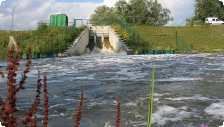
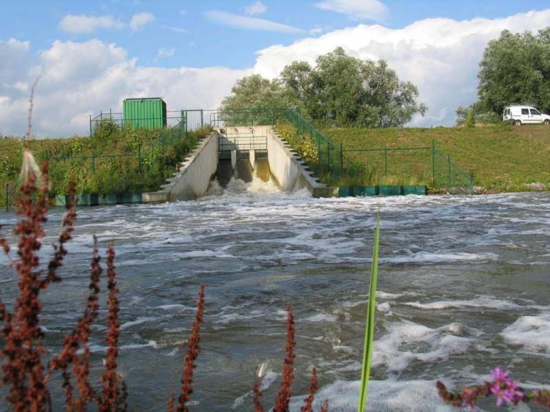
This system re-established a semi-diurnal tidal exchange via a network of sluices and culverts, allowing water to flow in and out in a regulated manner..
Information on Increased landscape storage capacity
The Lippenbroek measure improves total landscape water storage through multiple mechanisms. Soil moisture is high in sedimented zones, especially in the upper layers, due to fine particles and organic matter accumulation. The development of vegetated marshes supports significant evapotranspiration, contributing to local water cycling. The CRT system also regulates runoff, buffering tidal inflows and slowing drainage, which reduces hydrological peaks and encourages sediment deposition. Additionally, the formation of tidal creeks has enhanced infiltration, improving subsurface water exchange even in formerly compacted soils.
Ecosystem erosion control
1
Information on Ecosystem erosion control
Net annual sediment volume accumulation was around 212 m³/ha/year, accounting for both erosion and deposition, which confirms that accretion strongly outweighed erosion across the site.
Water quality overall improvements
N/A info
Information on Water quality overall improvements
With respect to water quality, the oxygen enriching impact, which is mostly due to the high inlet sluices acting as aerators, has been described as "striking". At the sluices, an immediate increase of up to 60% has been observed and a further 20% enrichment has been attributed to surface oxygenation. The restored marsh acts as a biogeochemical filter, especially serving as a sink for nitrogen and phosphorus, improving the water quality of the estuary.
Information on Water quality Improvements (P)
Over 10 years, the site evolved from a Phosphorus source to a Pohsphorus sink.
Information on Water quality Improvements (N)
The site acted as a nitrogen sink immediately after implementation.
Soil quality overall soil improvements
N/A info
Information on Soil quality overall soil improvements
Biodiversity enhanced
Information on Soil quality, overall soil physical properties
Sedimentation was strongly related to flooding frequency; i.e. the highest sedimentation rate was observed at sites inundated around 85% of the time. The average sedimentation rate is currently fairly high at approximately 4 cm/year. The lowest sites are accreting fastest, hence the polder is loosing slope. Outside the polder, in natural marshes, an increase in elevation would lead to a decrease in flooding frequency, and a consequent gradual decrease in sedimentation. Conversely in the CRT the flooding frequency is not directly coupled to elevation; the intake volume is stipulated by the sluice configuration.
1
With regards to birds, despite the high degree of disruption by humans (including site visitors,cyclists and walkers on the dike), a clear change in the numbers and species of birds using the site could be observed when compared to baseline conditions. Of the 4,089 individuals observed during the first year of monitoring, 30% were benthic foragers (19 species), 54% wetland-generalists (11 species), 8% terrestrial generalists (18 species) and 8% woodland birds (13 species). Occasionally night herons Nycticorax nycticorax and spoonbills Platalea leucorodia were observed feeding (Maris et al., 2008). In order for a CRT to fulfil a role for fish, safe passage of the cluvers/sluices is required.
Ecosystem impact climate regulation
No specific impact
Information on Ecosystem impact climate regulation
Not mentioned
Ecosystem provisioning services
1
Information on Ecosystem provisioning services
Flood protection
Key lessons
The Controlled Reduced Tide (CRT) technique employed at Lippenbroek has potential applicability for habitat creation along other heavily developed estuaries. It furthermore represents a technique which can significantly reduce the tidal prism of a site, without compromising the development of a range of intertidal habitats, thus minimising potential negative effects on small estuary systems. The technique also enables the establishment of intertidal habitats at lower elevations in the tidal frame than those of intertidal systems fronting a defence, and would thus be of potential use in areas where land levels behind a defence are relatively low compared to fronting levels. However, longer flood duration and low-turbidity stages may lead to higher accretion rates than in adjacent natural systems (ABPmer, 2008). Although this measure does reduce the sediment inflow, there is still high sedimentaation causing a need for maintenance, about 70 % of solid particles entering the area with tides stay there.
Success factor(s)
| Success factor type | Success factor role | Comments | Order |
|---|---|---|---|
|
Attitude of relevant stakeholders
|
secondary factor
|
Good cooperation with all partners involved |
1
|
Driver
| Driver type | Driver role | Comments | Order |
|---|---|---|---|
|
Past flooding events
|
main driver
|
1
|
|
|
Other
|
Loss of goods and services (loss of intertidal habitats)
|
2
|
|
|
Other
|
Loss of ecosystem functions (and thus loss of safety)
|
3
|
|
|
Balancing different objectives
|
main driver
|
The need to test this new approach to combine a flood control area with a new technique of controlled reduced tide, before implementing it on large scale.
|
Transferability
Any other embanked site with low elevation along the estuary. Opportunities exist in estuarine and coastal floodplain areas, but challenges include the cost of infrastructure, ensuring stakeholder support, and adapting the system to local conditions. Overall, the concept could be transferable to other flood-prone coastal areas with similar ecological goals.
Basin characteristics influence
The tidal nature of the Scheldt estuary, the flat topography, and the site's location within a former agricultural polder make it ideal for controlled tidal exchange, allowing natural sedimentation and habitat development.
Source(s)
English