Last update
2025
Summary
The Ministry-coordinated programme in Šumava National Park restores natural (pre-drainage) water regimes to mires, stabilising water tables, reducing fluctuations, and re-starting peat-forming vegetation and processes while engaging the public. Design has been refined around the Target Water Table (TWT) and a micro-catchment approach to size/space peat and wooden dams, infill drains, and return small streams to near-natural courses; public outreach and monitoring are integral.
Since 1999 the programme has expanded far beyond early pilots: by 2024, 65 locations in the Šumava region had been hydrologically restored, totaling 2,718 ha, with ~296 km of drainage channels blocked, 36 km of streams and 28 spring areas restored.
Within LIFE for MIRES (2018–2024), the project delivered ~2,181 ha of restored wetlands, 212 km of ditches blocked, 35 km of restored streams, and 28 springs, supported by 1,840 volunteers, strengthening habitat for flagship species such as black grouse and improving landscape water retention.
Overall, Šumava’s mire restoration now couples targeted hydrological design with long-term monitoring and public involvement to secure biodiversity gains and climate-relevant water storage at landscape scale.
Position
Latitude
49.0183
Longitude
13.5186
Project
NWRM
National Id
Czech_03
Installation date
2008
Implementation Status
Contact
REC
RBD code
CZ_5000
Transboundary
0
Photo gallery

Location of the project
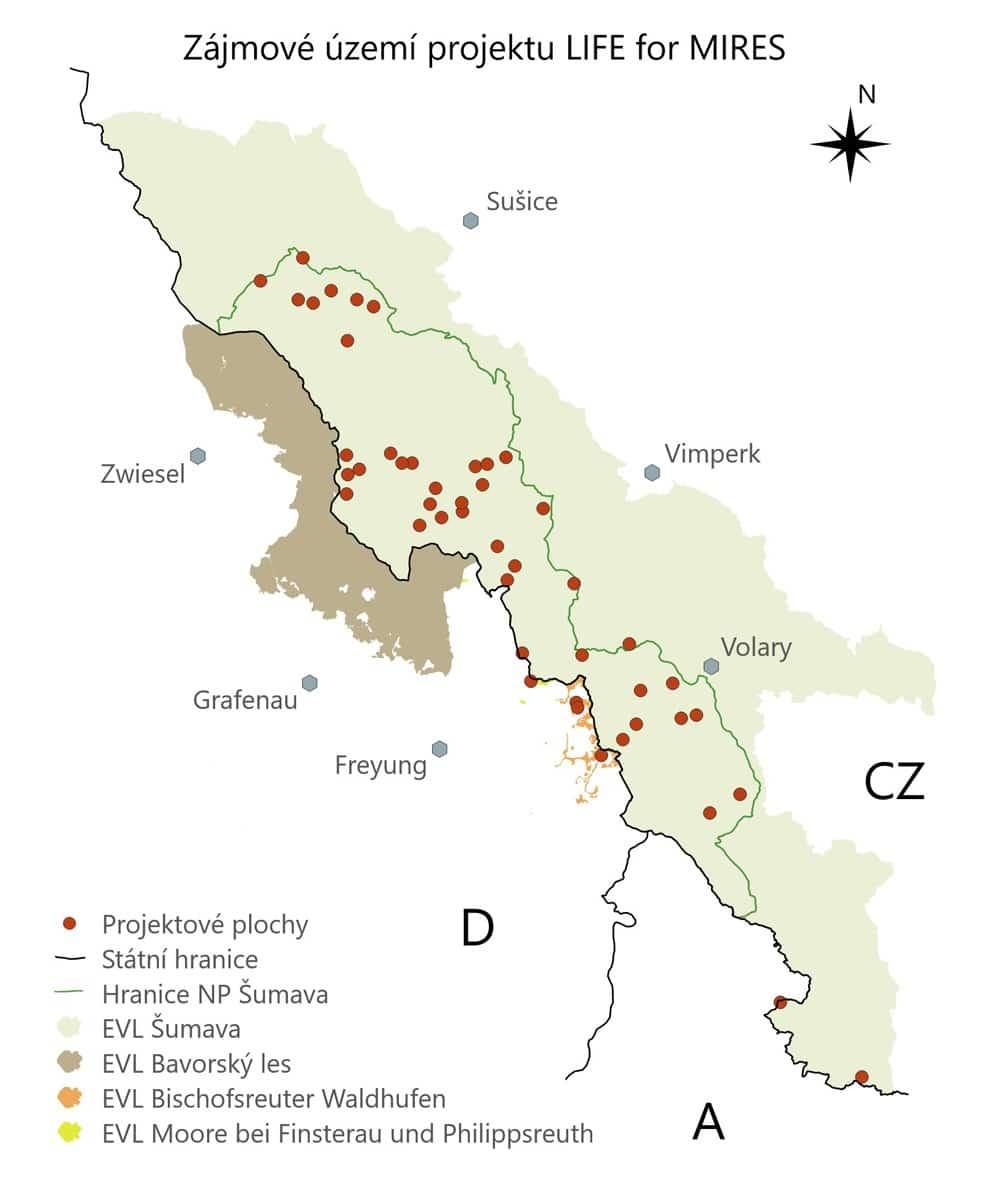
Across multiple mire localities inside Šumava National Park (South Bohemian & Plzeň Regions) along upper Vltava/Otava headwaters. Examples: Gerlova Huť lies south of the junction of roads 27 and 190; Jezerní slať sits between Kvilda and Horská Kvilda; Mrtvý luh above the confluence of Studená and Teplá Vltava.
NUTS Code
CZ03 - Jihozápad
Project's objectives
Early programme (1999–2014): restore drained mires by blocking ~62 km of ditches over ~590 ha, and pilot stream re-naturalisation (~2.3 km)—establishing methods and monitoring tied to TWT.
LIFE for MIRES phase (2018–2024): restore near-natural hydrology on ~2,059 ha across ~47 sites (43 on the Czech side), targeting the removal/closure of ~80 km of drainage channels and ~13 km of streams, with additional goals for springs and black grouse habitat. Delivery ultimately exceeded several targets: by late-2024 the programme reports ~196 km of ditches blocked, ~30–36 km of streams restored, 28 spring areas restored, and a cumulative ~2,718 ha of hydrological restoration across 65 locations (1999–2024).
LIFE for MIRES phase (2018–2024): restore near-natural hydrology on ~2,059 ha across ~47 sites (43 on the Czech side), targeting the removal/closure of ~80 km of drainage channels and ~13 km of streams, with additional goals for springs and black grouse habitat. Delivery ultimately exceeded several targets: by late-2024 the programme reports ~196 km of ditches blocked, ~30–36 km of streams restored, 28 spring areas restored, and a cumulative ~2,718 ha of hydrological restoration across 65 locations (1999–2024).
Involved Partners
| Authority type | Authority name | Role | Comments |
|---|---|---|---|
Climate zone
cool temperate moist
Temperature
3,2
Precipitation
1275
Runoff coefficient
0,1
Elevation range
1085 m
Slope range
<2
Vegetation class
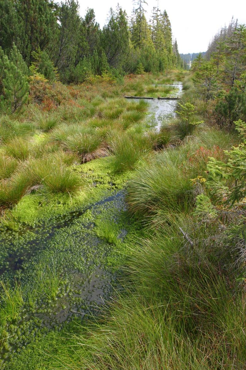
By habitat area inside Šumava NP, wetlands are dominated by bog woodland (91D0)* and waterlogged spruce forest; open active raised bogs (7110)* and transition mires (7140) are extensive but smaller by area (e.g., 3001 ha bog woodland vs 373 ha active raised bogs in park totals).
Water bodies: Ecological Status
Moderate
Water bodies: Chemical Status
Good
Water quality status
Principal pressures were historic drainage, stream straightening and peat/forestry operations
Project scale
Meso
Project scale specification
A regional, multi-site programme across the national park (dozens of localities). Since 1999, restorations reached ≈2,718 ha, with ≈296 km of drainage channels blocked and ≈36 km of streams plus 28 spring areas restored; LIFE for MIRES (2018–2024) contributed heavily (e.g., ~2,183 ha, 212 km ditches, 35 km streams).
Project area
500
Area subject to Land use change or Management/Practice change (ha)
500
Size
60
Size unit
km
Design capacity description
19 sites, nearly 60km of blocked ditches
Former mire
Total cost
510000
Costs total information
€510,000 before LIFE
LIFE for MIRES (2018–2024) : total eligible budget of €5,845,002
LIFE for MIRES (2018–2024) : total eligible budget of €5,845,002
Financing authorities
Type of funding
Sub-national funds
Comments
Co-financer pre LIFE also, management programmes.
Type of funding
EU-funds: Cohesion and regional development funds
Comments
State Environmental Fund : main financer for the initial restoration (pre-LIFE)
Type of funding
EU-funds: LIFE+
Comments
€3,507,002
Type of funding
National funds
Comments
Co-financer of the LIFE for MIRES project
Type of funding
Other
Comments
Co-financer of the LIFE for MIRES project
Compensations
0
Policy context
Since the late 1990s the Czech Ministry of the Environment and the Šumava NP Administration have run a long-term Programme for the restoration of mires and wetlands. It addresses pervasive drainage and channelisation from forestry, agriculture, roads and historical peat extraction that lowered groundwater, dried habitats and degraded headwater hydrology. The programme works inside a Natura 2000 context (Habitats Directive habitats such as 7110*, 7140, 91D0*) and, through LIFE for MIRES (2018–2024), restores mires, springs and small streams using a micro-catchment design guided by the Target Water Table (TWT) concept, fully in line with WFD aims to remove hydromorphological pressures (drainage ditches, straightened/eroded channels) and recover near-natural flow and level regimes.
Land ownership
Land administered by Šumava NP Administration. Czech state owns ~86%, municipalities ~10%, and other private/legal persons ~4%.
Community involvment
Yes
Design consultation activity
| Activity stage | Name | Key issues | Comments |
|---|---|---|---|
|
Environmental Education
|
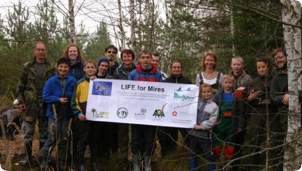
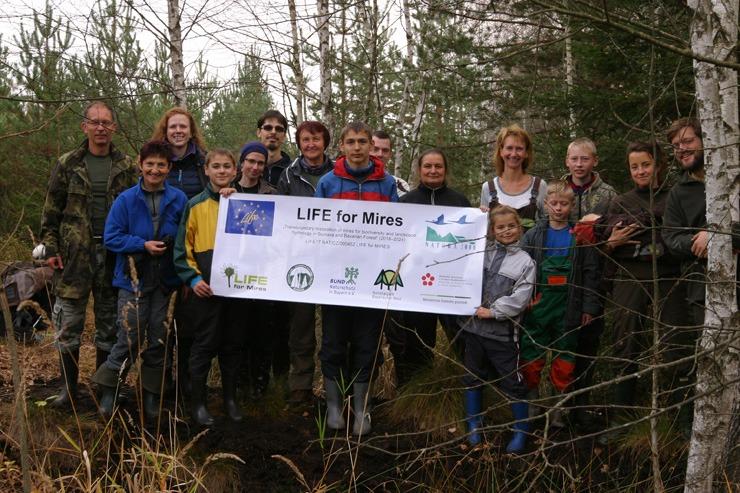
Both visitors and local people regularly attend †œMire Days†, which have been organised in the Å umava NP since 2008. In the ,rst half of such a mire day, people help with mire restoration a-er which they can visit undisturbed mires during the a-ernoon excursion.
Similar †œMire Weeks† have also been organised in collaboration with NGOs for already 8 years. *ese †œMire Weeks† are attended mainly by young people and students. In this way several hundred people from the whole Czech Republic have taken part in mire restoration |
Policy target
| Target purpose |
|---|
|
Increase Water Storage
|
|
Improved Biodiversity
|
Policy pressure
| Pressure directive | Relevant pressure |
|---|
Pressures remarks
Almost 70% mires have been modified by various human activities like forestry, agriculture and peat extraction in the past.
Policy impact
| Impact directive | Relevant impact |
|---|
Requirement directive
| Requirement directive | Specification |
|---|
Contractual arrangements
0
| Arrangement type | Responsibility | Role | Name | Comments |
|---|
Part of wider plan
1
Wider plan type
| Wider plan type | Wider plan focus | Name | Comments |
|---|---|---|---|
|
Landscape management programmes
|
Long-term hydrological and ecological monitoring is integral—groundwater levels and hydrochemistry are tracked against TWT targets to guide adaptive management.
The programme monitors water table (piezometers/loggers), hydrochemistry (e.g., pH, conductivity, DOC and major ions like SO4, NO3, NH4, PO4, Ca, Mg, Al, Fe), and biota/vegetation response; datasets are used to verify that ditch blocking/stream re-naturalisation meet TWT and to detect lingering drainage effects (esp. at springs).
Maintenance
Šumava NP teams (with LIFE partners and volunteers) inspect and repair peat/wood dams, re-infilling drains, reopen clogged channels to natural flow, and maintain visitor infrastructure as hydrologic conditions evolve.
Catchment outlet
Water table measured manually in all boreholes at nearly fortnight intervals. Automatic gauging(at 1h intervals) by piezometers was used in a selected 49 boreholes. Water samples from boreholes, ditches, runoff profiles from drained sites and samples from streams were taken monthly for a detailed hydrochemical analysis, including content of main cations and anions, pH, conductivity and DOC. Runoff from drained sites as well as amount of precipitation were measuered continualy.
Visitor infrastructure has been upgraded at multiple bogs (e.g., renewed boardwalks), both to protect sensitive peat surfaces and to channel tourism.
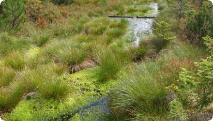
Restored streams were rapidly colonised by aquatic macroinvertebrates; the Hučina/Žlebský/Jedlový Potok programme tracks community development toward undisturbed references. On mires, restoration triggered vegetation and species recovery; one reported case is the increase of Listera (Neottia) cordata from ~50 plants (2008) to ~400 (2012) at a restored site.
Information on retained water
1999–2024 results: At landscape scale the programme blocked ~265–296 km of drainage channels, restored 36 km of streams and 28 spring areas, re-establishing retention and connectivity in many micro-catchments (65 localities; 2,718 ha).
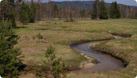
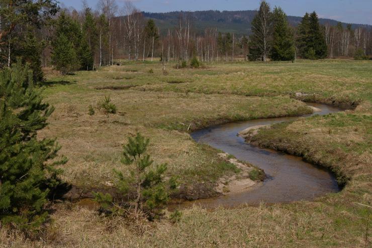
Example of hydraulic reconnection: the Hučina stream section was re-meandered, lengthened from 1.2 km to 1.7 km, old drains were infilled and several pools created.
Restoration raised the water table toward near-natural levels and reduced its fluctuations across restored mires; ditch blocking on slopes “did not result in flooding” but returned WT to the Target Water Table (TWT) for each habitat.
Information on runoff reduction
The fluctuations in the water table were reduced, especially in the dwarf-shrub bog sites and wet forests. The water table beneath Trichophorum lawns remained at almost the same level, but also here fluctuations were reduced.
Water quality overall improvements
Positive impact-WQ improvement
Information on Water quality overall improvements
Increased concentrations of PO4, Al, Fe. Hydrochemical changes were found to be much more expressed in wet forest than peatbog. Long-term monitoring is necessary for understanding ecological processes and complete cosystem response.
Monitoring shows hydrochemistry responds to rewetting, with changes most pronounced in minerotrophic mires; water quality outcomes depend on the share of mire types within a catchment.
Monitoring shows hydrochemistry responds to rewetting, with changes most pronounced in minerotrophic mires; water quality outcomes depend on the share of mire types within a catchment.
Soil quality overall soil improvements
N/A info
Information on Soil quality overall soil improvements
N/A info
Information on Ecosystem impact GHG soil carbon
The programme’s aim is to restart peat-forming processes and restore near-natural hydrology (a prerequisite for long-term carbon storage and landscape cooling), but no park-wide GHG flux figures were reported.
Key lessons
The Target Water Table (TWT) is a practical design tool, especially for bogs and sloping mires. Setting site-specific WT targets and spacing dams to meet them helps raise levels while avoiding unwanted flooding.
Long-term monitoring, including several years pre-restoration, is essential to judge success in mires and adjacent habitats, understand processes, and see whole-ecosystem responses. Šumava’s network of permanent plots and wells underpins this approach.
When assessing hydrochemistry at catchment scale, responses differ between minerotrophic mires and bogs; interpretation must account for mire type and local conditions.
A micro-catchment strategy suits mountainous terrain: combine ditch infilling with wood/peat dams on slopes, and re-naturalise headwater streams. Results show raised WT and reduced fluctuation, without broad overflooding.
Public engagement (volunteers, outreach) strengthens delivery and stewardship at scale across many localities.
Success factor(s)
| Success factor type | Success factor role | Comments | Order |
|---|---|---|---|
|
Financing possibilities
|
main factor
|
Strong, multi-year funding & partnerships (incl. LIFE). |
1
|
|
Available support tools
|
main factor
|
Proven techniques: ditch infilling + woody/peat dams; stream re-naturalisation. Clear hydrological design using TWT and micro-catchments. |
|
|
Conducted assessments (incl. economic)
|
secondary factor
|
Long-term monitoring network guiding adaptive management. |
|
|
Public participation
|
secondary factor
|
Volunteer involvement building capacity and social licence. |
Driver
| Driver type | Driver role | Comments | Order |
|---|---|---|---|
|
Organisation committed to it
|
main driver
|
Authority of the Natural Park
|
1
|
|
Availability of subsidies
|
secondary driver
|
2
|
|
|
Legal obligations
|
secondary driver
|
Strategy programes
|
3
|
Transferability
Highly transferable to drained mountain mires: set a TWT, block and infill drains, restore headwater streams, and monitor long-term. Take care with mire type (bog vs minerotrophic), slope/erosion, land tenure, and hidden spring drainage; these govern design, sequencing, and outcomes.
English