Last update
2025
Summary
Chaux Forest is a timber production area threaded by many small, originally sinuous headwater streams. A 2006–2008 LIFE pilot restored two intermittent tributaries; building on those results, the National Forest Office (ONF) scaled up to ~45 km of temporary tributaries from 2015, redirecting flows to former meanders, adding coarse woody material and sediment to counter decades of straightening/drainage that had widened and incised channels, sped floods and lowered near-surface water tables. Since 2021, ONF and the Doubs-Loue river syndicate have restored ~13 km of the Clauge mainstem inside the forest (2021–2023): narrowing/raising the bed with vegetated berms, gravel recharge, selective infilling of over-wide sections and engineered log structures. Monitoring reports a strong hydrological response: depending on context, the hydropériode of the Clauge headwaters and intermittent tributaries now increases by ~2–6 months per year (including +3–12 weeks in spring), alongside recovery of aquatic bio-indicators. In June 2025 the project received the national “Rivière en bon état” distinction and the Nature-based Solutions award from the Rhône-Méditerranée-Corse Water Agency. Next step: design for restoring the Tanche tributary, with works targeted for 2026.
Position
Latitude
47.0813
Longitude
5.6601
Project
NWRM
National Id
France_13
Installation date
2009-2025
Implementation Status
RBD code
FR43-Franche-Comté
Transboundary
0
Photo gallery
Location of the project
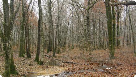
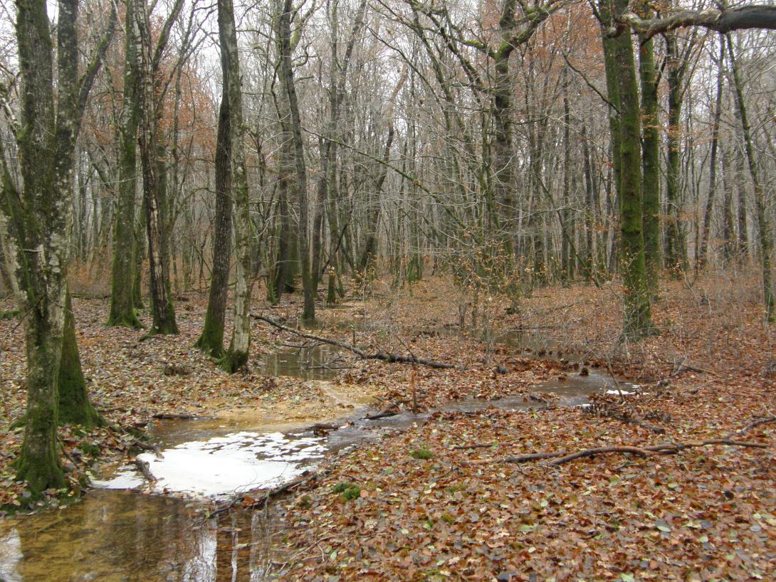
The Chaux forest is covered by a large number of small streams, originally winding and of small size (more than 400 km). They are located at the head of the catchment area and are tributaries of the Clauge.
NUTS Code
FR43 - Franche-Comté
Project's objectives
• Restore hydrologic function of the Chaux headwaters and mainstem (≈45 km tributaries; ≈12 km mainstem).
• Reconnect wet valley fringes and floodplain (reported several hundred hectares reconnected).
• Raise water table / lengthen hydroperiod; reduce incision/erosion; recover biodiversity (fish, macroinvertebrates, amphibians).
• Reconnect wet valley fringes and floodplain (reported several hundred hectares reconnected).
• Raise water table / lengthen hydroperiod; reduce incision/erosion; recover biodiversity (fish, macroinvertebrates, amphibians).
Involved Partners
| Authority type | Authority name | Role | Comments |
|---|---|---|---|
Climate zone
cool temperate moist
Temperature
11.6 °C
Runoff range
> 900 mm
Elevation range
260 m
Slope range
0-1%
Groundwater level
An impermeable clay layer is only 7 meters deep. The maximal water storage volume in the soil is easily reached after rain.
Vegetation class
Oak–beech high forest (with hornbeam), large lowland deciduous massif.
Water bodies: Ecological Status
Good
Water bodies: Chemical Status
Good
Water quality status
No major water quality issues observed. Roads, forestry and hunting activities could cause some pollution events though.
Project scale
Meso
Project scale specification
Work carried out on approximately 60 km of temporary tributaries of the Clauge River (until 2018), and more for the Tanche river (2025).
Project area
2 700 ha
Area specifications
Restored watercourse represents about 60 km, out of the estimated 450km of watercourses in the whole forest.
Size
60
Size unit
km
Community involvement, with pedagogic explainations.
Integrating a relfexion on waterways crossing and creation of bypass paths where possible.
Use of LIDAR technology when possible to identify the former river beds.
Integrating a relfexion on waterways crossing and creation of bypass paths where possible.
Use of LIDAR technology when possible to identify the former river beds.
Low-gradient, alluvial/lacustrine valley floors (ancient Rhine deposits, “lac Bressan” context) with hydromorphic, fine soils; shallow water table; dense legacy drainage/straightening; extensive forest road network. Constraints: Natura 2000 and Water Law permitting windows; soil bearing capacity and machinery impacts. Favourable: public ownership/ONF stewardship, local wood/sediment availability, clear LiDAR-visible paleo-meanders.
Almost all the temporary tributaries of the Clauge being originally meandriformes, a remeandering operation is justified following their transformation in the 1960s into deep rectilinear ditches, so that they can regain a hydrological functioning that allows them to support an associated biodiversity.
Total cost
€ 1,429,000
Costs total information
• 2015–2019 (headwater tributaries, ~45 km): €581,500 total. Funding: €465,200 Agence de l’eau RMC; €116,300 ONF self-financing. Tranche costs: T1 €263,500; T2 €198,000; T3 €120,000.
OIEau
• 2021–2023 (mainstem Clauge, ~12–13 km): €848,000 (excl. VAT). Funding: €594,000 (70%) Agence de l’eau RMC; remaining 30% by project owners/partners.
OIEau
• 2021–2023 (mainstem Clauge, ~12–13 km): €848,000 (excl. VAT). Funding: €594,000 (70%) Agence de l’eau RMC; remaining 30% by project owners/partners.
Financing authorities
Type of funding
Sub-national funds
Type of funding
National funds
Compensations
0
Policy context
The Chaux forest is covered by a large number of small streams, originally winding and of small size (more than 400 km). All the temporary tributaries of the Clauge were transformed in the 1960s into deep straight ditches via canalization works. ONF led early phases (post-LIFE 2008 pilots) with Univ. of Franche-Comté; since 2018 the Syndicat Mixte Doubs-Loue (SMIX) shares/co-leads under GEMAPI for mainstem works; Agence de l’eau RMC is principal funder. The measure targets WFD ecological status via hydromorphological recovery, mitigating historical drainage/channelization and climate-driven drought stress in a Natura 2000 forest.
Land ownership
State-owned: the Forêt domaniale de Chaux belongs to the French State; land is managed by ONF (project owner).
Community involvment
Yes
Design consultation activity
| Activity stage | Name | Key issues | Comments |
|---|---|---|---|
|
Design phase
|
Consultation meetings
|
Preconcieved ideas from local residents, representatives, hunters, etc. : "The project will flood the forest", "The Clauge floods will be worsen".
|
The goal was to explain how the various preconcieved ideas were wrong.
|
|
Implementation phase
|
Conference with officials and local representatives (2018)
|
The budget allowed to the project was considered by some as too expensive, especially in comparison with the smaller budget allowed for forest roads or other infrastructures.
|
Explaining the project and how it works.
|
|
Implementation phase
|
Press articles
|
A significant effort was made to communicate informations to the local press.
|
|
|
Other
|
Information panels on a new wooden footbridge over the river downstream (2025).
|
The goal is to communicate with people directly on the field.
|
Policy target
| Target purpose |
|---|
Target Remarks
Significantly restoring the hydraulic functioning of the Clauge and improving the conservation status of the species covered by the Habitats Directive.
Policy pressure
| Pressure directive | Relevant pressure |
|---|---|
Policy impact
| Impact directive | Relevant impact |
|---|
Requirement directive
| Requirement directive | Specification |
|---|---|
|
Other EU
|
Habitats Directive
|
Requirement directive remarks
Emblematic species to be preserved in a Natura 2000 zone.
Contractual arrangements
0
| Arrangement type | Responsibility | Role | Name | Comments |
|---|
Part of wider plan
0
Wider plan type
| Wider plan type | Wider plan focus | Name | Comments |
|---|
A monitoring protocol was set up in 2017 with the University of Franche-Comté (technical assistant) and the ONF (National Office of Forest), with the help of 2 master trainees.
Entomological monitoring is carried out in the spring, at the net and in the watercourses and is led by the University. It is carried out before and after, at a control site, and at restored sites, with a time grid every two and three years. The control shows that the observed changes are not due to climatic variations.
Piezometric monitoring (individual or online). : About twenty piezometers have been installed with weekly automatic readings.
Dendrometric monitoring : At the level of the piezometers, vegetation monitoring plots are placed by the ONF (height, diameter, health status, dominance) on control plots of 1000m². The population evolution will be monitored over the long term.
2 weather stations will be installed in 2025 to study pluviometry and nebulosity.
Maintenance
Almost no maintenance operations, the idea is to let ecosystems repair themselves. Some small operations can be carried out shortly after installation (removing unwanted debris for example).
Comparison with a control site.
Social benefits are limited, as the forest is not a huge tourism area.
Economic benefits mainly come from the provided peak-flow reduction downstream.
Economic benefits mainly come from the provided peak-flow reduction downstream.
Hydrological effects
The increase in low-flow rates and the extension of the hydroperiod of the temporary streams, as well as the peak-flow reduction downstream..
Information on retained water
Hydroperiod increase +2–6 months/year (incl. +3–12 spring weeks) in restored reaches; water table residence time increased.
Restored channel complexity (sinuosity, benches, large wood), floodplain reconnection (hundreds of ha), and attenuation of downstream flood effects during high water.
Restored channel complexity (sinuosity, benches, large wood), floodplain reconnection (hundreds of ha), and attenuation of downstream flood effects during high water.
Maintenance baseflow
1
Information on Maintenance baseflow
Increase of the temporary watercourses' hydroperiods of about 20 days.
River flow time gains go up to 2 to 6 months, and 3 to 12 weeeks in spring specifically. The results vary a lor ont the local contexts and weather.
River flow time gains go up to 2 to 6 months, and 3 to 12 weeeks in spring specifically. The results vary a lor ont the local contexts and weather.
Information on Increased groundwater level
Piezometric monitoring shows an increase in the hydroperiod (+20 days) because the time of presence of water in the watercourse is longer, as these are surface aquifers that are in silts and dry in summer, water is more available for trees in spring. When the time of presence of water in the stream is extended, it is also extended in the groundwater table.
Information on Restoring hydraulic connections
The hydrosystems improved as wanted. Waterways are balancing themselves on the way to complete restoration.
1
Biodiversity monitoring reveals a better attractiveness of the spawning sites for amphibians (frogs, salamander, newt, reproduction multiplied by 10) and amphibians because the river was not initially biogenic;
It also reveals an improvement in habitat for entomofauna, with the number of taxa multiplied by 2, a recovery by ephemeropterans, perlids and trichopterans protected at the European level (e. g. Hagenella clathrata classified as endangered (EN) on the IUCN Red List). There is also an improvement in quality (i.e. more demanding species that are dependent on wetlands).
It also reveals an improvement in habitat for entomofauna, with the number of taxa multiplied by 2, a recovery by ephemeropterans, perlids and trichopterans protected at the European level (e. g. Hagenella clathrata classified as endangered (EN) on the IUCN Red List). There is also an improvement in quality (i.e. more demanding species that are dependent on wetlands).
Information on Ecosystem impact climate regulation
Climatic impacts will be assessed using data from the weather station installed in 2025. Positive impacts (heat reduction) due to nebulosity improvements are expected.
Key lessons
As of 2025, the morphological restoration is considered a success. The restoration was awarded a "Nature Based Solution Price" in 2025 by the French ministry of environment.
Anticipation is needed to carry out a similar project. It allows to prevent future problems, human or technical.
It is better to use the available technologies (LIDAR, modeling) for design and communication.
The sponge effect is working, but is not perfect : the massive october 6 2024 flash flood showed how even with fucntioning sponge measures flood can cause catastrophes.
Success factor(s)
| Success factor type | Success factor role | Comments | Order |
|---|---|---|---|
|
Other
|
main factor
|
The presence of only one forest manager over a large area. Many differetn land woners and managers would have slowed down and/or prevented a similar project to be implemented. |
1
|
|
Available support tools
|
main factor
|
The access to LIDAR technology to identify the various former river beds helped to restore them. |
2
|
|
Available support tools
|
main factor
|
The modelisation work carried out by TELEOS allowed to show the local community how this project worked. |
3
|
Driver
| Driver type | Driver role | Comments | Order |
|---|---|---|---|
|
Other
|
main driver
|
The fact the habitat was seriously degraded and other experience of successful restoration of habitat on a similar area was a key driver, as positive results were already forecasted from the beginning.
|
1
|
Transferability
Highly transferable to low-gradient forested headwaters where legacy drainage/straightening dominates. Critical enablers: public land control; integrate works with forest operations to minimize new crossings; use local materials; LiDAR-guided design; secure Water Law/Natura 2000 permits and work within seasonal windows; plan multi-year adaptive monitoring.
Cost effectiveness
The project was a compromise between the most effective (filling of all straightened river beds) and least expensive (leaving ecosystem heal by themselves), choosen to be the most cost effective.
English