Last update
2025
Summary
The Körös-ér catchment lies in a drought-prone part of Hungary and is a heavily modified water body with nutrient inputs from urban and agricultural sources. Recurrent water-logging causes temporary flooding in spring and after cloudbursts. To address both extremes (floods and shortages) the water directorate upgraded control structures, reconnected ~2.5 km of former floodplain at the estuary, improved sluices to allow retention while clearing bottlenecks for flood conveyance, increased urban drainage capacity (via a closed conduit), and added an upstream retention pond. Since completion (2011), management has shifted toward active small-water retention: today water is stored at three points along the Körös-ér - at the mouth (0+000), at 5+850 (betétpallós gate), and at 16+675, where DINPI built a retention structure in 2022 with a lateral sluice and ditch to inundate low-lying grasslands, boosting retained volumes and waterfowl habitat (boards are removed at high water; overtopping is possible). In 2025, under the “Vizet a tájba / Water to the Landscape” programme, managed in-channel storage and controlled inundation were also implemented near 22+884 (≈14 ha, ≈46,000 m³). Fish from the Tisza have re-appeared in reaches previously isolated.
Position
Latitude
47.047282
Longitude
19.984447
Project
NWRM
National Id
HU_03
Installation date
2011-08
Implementation Status
Contact
Gábor Ungvári, REKK
RBD code
HU1000
Transboundary
0
Photo gallery
Location of the project
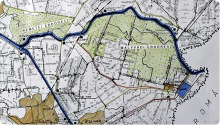
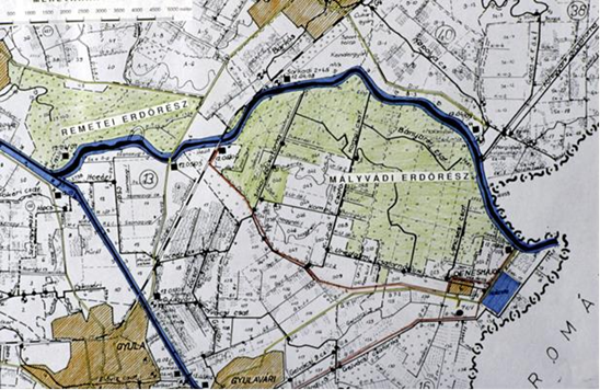
Former floodplain of the River Körös near the Town Gyula, County Békés
NUTS Code
HU10 - Közép-Magyarország
Project's objectives
Reconnect former floodplain at the estuary on a ~2.5 km section.
Upgrade sluices to enable retention and remove bottlenecks to improve flood conveyance (works applied along the ~40 km channel).
Provide urban drainage capacity: build a closed conduit (~1,200 m) through Nagykőrös and raise drainage coverage from 37.7% to 100%; create ~4 ha of green space at surface.
Create an upstream retention pond to control runoff and store water (design ~100,000 m³).
Protect groundwater in town by using a closed culvert instead of an open channel.
Modify the Tisza confluence structure to allow fish passage and enable operation of a seasonal (later permanent) reservoir at the mouth.
Involved Partners
| Authority type | Authority name | Role | Comments |
|---|---|---|---|
Climate zone
warm temperate dry
Temperature
10,3
Annual rainfall range
300 - 600 mm
Runoff coefficient
0,25
Runoff range
0 - 150 mm
Evapotranspiration
800
Imperviousness
0,25
Elevation range
85 m
Slope range
0-1%
Vegetation class
Species-rich wet meadows (grasslands) : chiefly Moliniа meadows (6410, ~244 ha) and alluvial meadows (6440, ~202 ha) along the Kőrös-ér/Gógány-ér, with smaller patches of willow/ash riparian woods.
Water bodies: Ecological Status
Moderate
Water bodies: Chemical Status
Good
Project scale
Meso
Project scale specification
The forest site is cc 2000 ha
Performance timescale
Immediate
Project area
48100
Area subject to Land use change or Management/Practice change (ha)
5
Size
5
Size unit
ha
Lifespan
33
The basic restoration principle was to simulate the environmental conditions for the forest it had before the river regulation works as much as possible. Some design principle:
Use the existing infrastructure and former river beds, channels as much as possible in a landscape friendly manner.
Minimize future operation and maintenance costs.
Do not create conflicts with the other water uses of the area. The functioning of the system must be agreed with the other land users and owners of the area.
100000 m3
Design capacity description
Maximum quantity of water derived from the river depends on the water level. During a year there is cc 180 days for water supply. During this period cc 2 million m3 water arrives into the area
The high cost of a previous attempt to pump water for the area proved prohibitively expensive and made it clear that only gravitational supply can provide sustainable solution.
Negative way: The watershed belongs to three counties NUTS HU102 , 322, 331, and two different regions HU1, HU3 that belong to two different regional development fund subsidy level. It caused big difficulties and delay to secure EU funding and acknowledge the overstretch characteristic of the project.
Positive way: The areas that are necessary for the development of the structures belong to public ownership. Upstream from the settlement there is interest for recreational use of the stored water
Positive influence effectiveness
The isolation of the area and lack of the risk of flooding nearby areas made it an easy case from the water directorate’s point of view.
Total cost
970.000 €
Costs investment
3667000
Costs investment information
Present value of the project 5% dc rate 30 year period, 2008 € exchange rate
Costs capital
3730000
Costs capital information
Project calculations include the estimated cost reduction in operational costs
Costs land acquisition
145000
Costs land acquisition unit
€ (total value)
Costs land acquisition information
Land value is part of the capital cost, cc 5ha was purchased
Costs operational
25400
Costs operational information
The NPV of total maintenance cost 57.100€, but there is a forgone cost of desludging 31.700€
Costs operation maintenance information
There are cost savings due to forgone pumping cost 88.800€ (NPV, 5%, 30 year lifespan)
Financing authorities
Type of funding
Local funds
Type of funding
EU-funds: Cohesion and regional development funds
Compensations
0
Policy context
The Körös stream catchment lies in the most droughts stricken region of Hungary. There are repeating surface water resource shortages, the ground and subsurface water levels are declining at the uppers section. There are nutrient overload in the stream and in the ground water as well both from point and diffuse sources and both agricultural and urban. There are hydro-morphology problems as well.
Meanwhile recurring water logging periods cause temporary problems for the settlement and the agricultural areas.
Meanwhile recurring water logging periods cause temporary problems for the settlement and the agricultural areas.
Land ownership
All public ownership; about 5 ha were purchased.
Community involvment
No
Design consultation activity
| Activity stage | Name | Key issues | Comments |
|---|
Policy target
| Target purpose |
|---|
|
Runoff control
|
|
Pollutants Removal
|
|
Groundwater Recharge
|
Target Remarks
Regulation of hydrological cycle and water flow
Self-regulation of water by filtration / storage / accumulation by ecosystems
Self-regulation of water by filtration / storage / accumulation by ecosystems
Policy pressure
| Pressure directive | Relevant pressure |
|---|---|
|
WFD identified pressure
|
4.1.1 Physical alteration of channel/bed/riparia n area/shore of water body for flood protection
|
Policy impact
| Impact directive | Relevant impact |
|---|---|
|
WFD identified impact
|
Damage to groundwater dependent terrestrial ecosystems for chemical / quantitative reasons
|
Requirement directive
| Requirement directive | Specification |
|---|---|
|
WFD-mitigation of significant pressure
|
Adverse effects of hydromorphological changes on groundwater and riparian ecosystems
|
Requirement directive remarks
The measures were made before Hungary joined the EU, so the specifications are backward induction of the recent classification.
Policy challenges requirements
The droughts challenge, but this development wasn’t induced along national policies. It was a local initiative to tackle the site specific problems that originates in a more general, regional scale effect.
Contractual arrangements
0
| Arrangement type | Responsibility | Role | Name | Comments |
|---|
Part of wider plan
1
Wider plan type
| Wider plan type | Wider plan focus | Name | Comments |
|---|---|---|---|
|
Implementation of the WFD
|
There is no permanent monitoring about the changes what introduction of the measure generates, there are event-by event surveys that are conducted mostly from botanical approach.
chemical
Maintenance
There is no extra maintenance required. There is no eutrophication process in the channel system due to the shadow that the forest provides. It means that there were no need to clear emerging vegetation or dredge the branches.
Catchment outlet
Comparison to the previous status:
Groundwater - water level in wells situated in the forest.
Biomass – not yet assessed, it will take place next year in the context of the decadal forestry plan supervision
Groundwater - water level in wells situated in the forest.
Biomass – not yet assessed, it will take place next year in the context of the decadal forestry plan supervision
The prevention of the loss of future timber production due to water shortage is the main benefit of the application.
Potential increase of timber mass growth rate compared to other forest sites will be investigated next year (20 years, two forest planning cycles from the implementation).
Cost reduction due to natural regeneration of some tree species (for example fraxinus ornus).
Farmer & private land participation: under Vizet a tájba, landowners around Nagykőrös, Abony, Törtel, Tószeg, Mikebuda offered parcels for temporary inundation; the scheme targets drought relief, soil-water supply and local micro-climate cooling.
Information on retained water
The Körös-ér–Gerje–Perje system’s retention & controlled inundation now result in “several hundred thousand m³” infiltrating to soil, raising groundwater levels (programme-level statement that includes Körös-ér).
Information on increased water storage
Measures impact on groundwater is positive, there are enhanced possibility of infiltration at the retention pond .
The reason of applying a closed culvert (among other aspects) across the settlement was the protection of groundwater, because an open watercourse would drain the groundwater at low water periods.
The reason of applying a closed culvert (among other aspects) across the settlement was the protection of groundwater, because an open watercourse would drain the groundwater at low water periods.
Runoff reduction
2 million m3/year
Information on runoff reduction
Runoff is attenuated by the detention pond upstream the settlement. The flow inside the settlement is controlled by the capacity increase of the crossing culvert.
Information on Peak flow rate reduction
Peak flow is reduced to the capacity of the detention pond, while other part of the catchment no runoff attenuation developments were made the emphasis was given to the storage areas
Maintenance baseflow
1
Information on Increased groundwater level
There is no reliable monitoring, but a 2,5 meter increase of ground water level was detected in a forest dwell 300 meters from the channel after the re-introduction of the water supply of the area.
Information on Soil moisture
Detention ponds and storage areas will increase infiltration, but only very local effect
Information on Restoring hydraulic connections
Hydraulic connections are developed cc half of the year 180 days
Information on Water quality overall improvements
The detention pond above the settlement will serve as a reserve for dilution when water quality problems arise due to low water quantities in the stream. (The effluent of the town†™s treatment plant discharges into the stream)
Information on Soil quality overall soil improvements
neutral, no change
1
Improved habitat for species. Increased diversity of plant and bird species. There are surveys and list of the species, but it is not quantitative.
The 2022 DINPI structure at 16+675 expands shallow wet grassland habitat and supports waterfowl nesting/feeding.
The 2022 DINPI structure at 16+675 expands shallow wet grassland habitat and supports waterfowl nesting/feeding.
Key lessons
The development aims to manage both water extreme of a small water course water logging problem in residential and agricultural areas and low water or lack of water in the stream that results in bad water quality due to point and diffuse effluents. The technical elements are necessary, but not sufficient parts of NWRM measures. Using only the limited public lands along the water courses can provide only a limited set of the potential effects. Water quality improvements by natural assimilation needs more surface to interact with the polluted water.
EU funds can help overcome the technical shortages, but it can†™t make the interest resolution on a landscape scale avoidable between the different public and private interests. The works are ready to supply the potentially changing demand for more retention.
Surface water supply is an effective way of recharging groundwater storage capacity of forest soil in order to reduce droughts risk by enhancing the natural interseasonal allocation of water.
The key difference of this application compared to an area with generally the same problems is the possibility to sort out the transaction costs that emerge in an area with multi-party ownership.
If the suitable complex knowledge happens to be at the right place, no further incentive is needed to take advantage of an upcoming possibility. – It highlights the fundamental need for education about the complex nature of the water-land useecosystem nexus.
Success factor(s)
| Success factor type | Success factor role | Comments | Order |
|---|---|---|---|
|
Financing possibilities
|
main factor
|
1
|
|
|
Legal obligations
|
main factor
|
2
|
Driver
| Driver type | Driver role | Comments | Order |
|---|---|---|---|
|
Organisation committed to it
|
main driver
|
The forestry management’s unequivocal understanding of the structural problem that threatens the sustainable operation: the lack of inundations. They grasped the first occasion to finance and negotiate such a development.
|
1
|
Flexibility adaptability
The application depends on the sufficiently lasting high water level in the river that now a downstream dam provides. It solves the most pressing predictability issue.
On the other hand the forest can play an equalizer role. The area could absorb more water, if technical flood risk concerns were solved. It means the area can adapt to different regimes to receive water. On the other side, because of the forest’s ability to store water it can adapt by decreasing intake in case of growing competing water demands during water shortage periods in the summer.
On the other hand the forest can play an equalizer role. The area could absorb more water, if technical flood risk concerns were solved. It means the area can adapt to different regimes to receive water. On the other side, because of the forest’s ability to store water it can adapt by decreasing intake in case of growing competing water demands during water shortage periods in the summer.
Transferability
There were no such applications proposed elsewhere in the country.
The application could be used all around the country.
The necessary precondition is the complex problem identification and task definition at the responsible/acting institutions.
The missing key element of transferability is the conflict resolution in order to create the necessary conditions of land conversion.
Basin characteristics influence
The relief of the area – the former river channel and side arm residues - provided a natural basis for the new water supply network. A key point of providing water from the river for previously cut floodplains is the duration of suitable water level.
Cost effectiveness
The applied sluices for this purpose are very robust, low-tech solutions. There were no other solution that provides control of the inflow for lower price.
English