
Nummela 'GATEWAY' Wetland Park, Finland

Last update
2025
Summary
In 2010, the Nummela Gateway Wetland Park (2 ha) was built as both a water-quality mitigation landscape and an urban park. Early monitoring (2010–2011 spring floods) and a three-year ecological survey showed rapid self-establishment, rising biodiversity and multiple ecosystem services (erosion/flood control, pollutant reduction), alongside strong recreational and educational use. According to the project managers, EU LIFE+ “Urban Oases” began in 2012; from 2012–2016 the team deployed high-frequency, year-round monitoring and also sampled sub-catchments to separate urban vs. agricultural loads, which guided the construction of an additional upstream wetland (Nummelan Niittu). Peer-reviewed work documents seasonal nutrient-removal dynamics and highlights the creation of endangered clay-stream habitats. Today, municipal pages present both Portti and Niittu as accessible nature sites (trails, bird tower). The municipality also continues periodic lake-water monitoring in Enäjärvi under local programmes. Comparative studies (including Nummela) underscore how vegetation and design influence phosphorus removal performance.
Position
Latitude
60.3277
Longitude
24.3375
Project
NWRM
National Id
Finland_02
Installation date
2010
Implementation Status
RBD code
FIVHA2
Transboundary
0

Location of the project
Nummela (Vihti, Uusimaa), between Porintie / Highway 2 (Vt 2) and Enäjärvi’s Ridalinlahti bay; parking at the end of Ritalantie with access via Luhtaniitynpolku trail.
NUTS Code
FI1B - Helsinki-Uusimaa
Project's objectives
Water-quality mitigation before Lake Enäjärvi, with the wetland expected to provide only moderate pollutant removal because the mean inundated area was ~0.1% of the watershed, whereas 1–5% wetland area is commonly suggested for water-pollution control. Peak-flow attenuation and erosion reduction were also explicit aims.
Habitat restoration/creation, specifically re-establishing clay-dominated stream habitat (classified as critically endangered in Southern Finland) and acting as a “gateway” for lake fauna into the Kilsoi stream corridor.
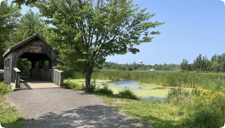
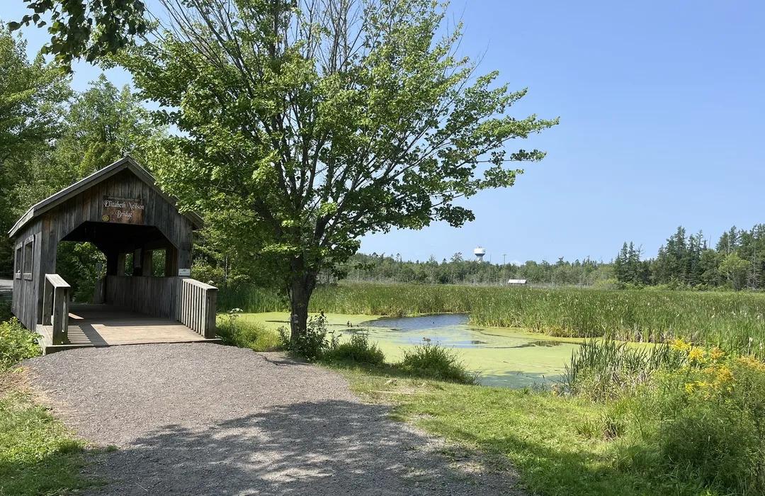
Recreation & environmental education via an accessible urban park with nature trails and information boards.
Catchment-scale concept: create an interconnected chain of wetlands along ~1.5 km of the degraded stream corridor to manage flashy urban/agricultural runoff before it reaches the lake.
Designed as a research/monitoring site (“field laboratory”) for water quality and flows, greenhouse gases, vegetation, biota and ecosystem services from the outset.
Involved Partners
Authority type Authority name Role Comments
Local water authority
University of Helsinki
Initiation of the measure
Other
Municipality of Vihti
Initiation of the measure
NGO
The Water Protection Association of the River Vantaa and Helsinki Region
Monitoring
Other
Uusimaa, Centre for Economic Development, Transport and the Environment
Other
Regional Policy: Cohesion Funds, ERDF

Climate zone
cool temperate moist
Temperature
4.6
Precipitation
650
Elevation range
61m
Vegetation class
Herbaceous wet meadow/emergent vegetation dominates (self-established), with grass-dominated meadow on moderately dry zones (e.g., Poa, Calamagrostis) and riparian willows; open water and small habitat islands are present.
Water quality status
Phosphorus-rich clay erosion from fields, de-icing salt inputs (salinity up to 10–20% of Baltic Sea water during snowmelt in the stream), and warmer urban runoff (~+5 °C vs other sources) were identified pressures to the Kilsoi stream/Enäjärvi system.

Project scale
Micro
Project scale specification
a local, site-specific urban wetland park and short stream corridor within the Nummela district (≈2 ha wetland park at the mouth of a ~500–550 ha sub-catchment), i.e., a localised hydromorphological & stormwater intervention rather than regional basin management.
Performance timescale
1 - 4 years
Project area
500
Area subject to Land use change or Management/Practice change (ha)
2
Size
2
Size unit
ha

Total cost
€ 87,000
Costs total information
Nummela Gateway Wetland Park (2 ha) - €62,000
Restoration of 250 m of the Kilsoi stream - €25,000
Financing authorities
Authority name
Uusimaa Region
Type of funding
Sub-national funds
Comments
regional authority of the Uusimaa Centre for Economic
Development, Transport and the Environment (UUDELY)
Authority name
Vihti municipality
Type of funding
Local funds
Comments
Budget of Vihti municipality
Authority name
European Union
Type of funding
EU-funds: LIFE+
Comments
For follow up project called Urban Oasis
Compensations
0

Policy context
1) due to land-use changes and inadeqaute urban waste water management the Lake Enäjärvi watershed have resulted in poor water quality and related adverse impacts such as increased algal blooms and fish mortality.
2) problems such as erosion, flooding, draught, habitat degradation and low water quality were common in the area, preventing local people from accessing and enjoying from their surrounding natural environment
Land ownership
The Municipality of Vihti acquired land along the Kilsoi stream corridor for the project and designated it as a functional water-protection zone. This includes the site of the Nummela Gateway Wetland Park.
Community involvment
Yes
Design consultation activity
Activity stage Name Key issues Comments
Policy target
Target purpose
Pollutants Removal
Improved Biodiversity
Oher Societal Benefits
Runoff control
Peak-flow reduction
Policy pressure
Pressure directive Relevant pressure
Policy impact
Impact directive Relevant impact
Requirement directive
Requirement directive Specification
Contractual arrangements
1
Arrangement type Responsibility Role Name Comments
Contractual agreement
Supporting
Implementation
Th partnership agreement on implementation of the LIFE+ project
for LIFE+ project Urban Oasis
Part of wider plan
1
Wider plan type
Wider plan type Wider plan focus Name Comments
Local
Urban
Vihti municipality plan
Local municipal plan reflects the change in zoning of land use.

Intensive monitoring was run during LIFE+ Urban Oases (2012–2016) by the University of Helsinki and partners, with the municipality continuing periodic Enäjärvi water-quality monitoring afterwards.
During and after construction, teams tracked water quantity and levels (weirs, water-level loggers), turbidity (used as a proxy for total phosphorus at Gateway), suspended solids, temperature, and conductivity/salinity (for road-salt impacts). Dissolved oxygen at inflow/outflow shows seasonal patterns. Vegetation plots recorded species richness and succession. In parallel, the site hosted eddy-covariance measurements of CO₂ and CH₄ fluxes. Ongoing municipal programmes sample Enäjärvi seasonally for core limnological indicators.
Maintenance
Routine needs are minimal—annual nature-trail upkeep, with wet-meadow management and sediment-trapping pool maintenance roughly every 5–10 years.
Edge of Field/Plot
Monitoring was performed to monitor impacts with regard to water quality and quantity, carbon content in soils, greenhouse gases, vegetation as well as evaluating ecosystem services.
Recreation & education: trails, interpretive boards; the site is promoted as a public park and nature destination by the municipality/visitor pages.
Information on retained water
Flood mitigation & flow moderation reported qualitatively; no site-level volumes given. Hydraulic features include a stilling pond and rock-bottom dams “to keep water level relatively even.”
Peak flow rate reduction
40
Peak flow rate reduction unit
%
Ecosystem erosion control
1
Water quality overall improvements
Positive impact-WQ improvement
Information on Water quality overall improvements
Wetland decrease the risk of eutrofication in Lake Enäjärvi. High-frequency year-round monitoring (0.5 ha wetland at mouth of an urban/agricultural catchment): incoming loads 24 g P m⁻² yr⁻¹ and 130 g NO₃-N m⁻² yr⁻¹; retention 3.1 g P m⁻² yr⁻¹ and 18 g NO₃-N m⁻² yr⁻¹ (≈ 13% TP and 14% NO₃-N annual reduction). At a monitored wetland with 0.1% wetland:catchment ratio, average annual TP reduction ~10%, with up to 71% TP reduction in individual events during the growing season. Highest load reductions occurred during heavy rain/snowmelt outside the growing season.
Water quality Improvements Phosphorus (P)
9
Water quality Improvements (P) unit
% reduction pf pollutant
Information on Water quality Improvements (P)
Wetland retained phosphorus comparatively most efficiently in July, but terms of terms of absolute quantity in October – November.
Water quality Improvements (TSS)
Monitoring data from late April 2012 show two peaks of suspended sediments following two rain events. In both cases the wetland reduced sediment load into the lake (by 24% and 12%, respectively)
Water quality Improvements Total Suspended Solid (TSS)
12
Water quality Improvements (TSS) unit
% reduction pf pollutant
1
These wetlands were constructed by excavation in abandoned crop fields. Vegetation was allowed to selfestablish. Seven vegetation zones were identified at the Gateway wetland: natural flood meadow by the lake, constructed islands, constructed wetland area, two dryer wet meadow areas, area of Salix shrubs, and adjacent forest edge. Annual monitoring for species and foliar coverage in summers of 2010, 2011 and 2012 (94 area 0.5m2 plots) revealed that the vegetation selfestablishment at the Gateway wetland was rapid, rich in taxa, and dominated by native wetland species. Only two alien species were identified: Elodea canadensis in deep water areas and Epilobium adenocaulon in dryer meadow areas. Coverage exceeded 90% in 2012.
Ecosystem impact climate regulation
Impact on GHGs (net emissions and storage) including soil carbon
Information on Ecosystem impact climate regulation
GHGs have been continuously monitored at the Gateway wetland by the eddy covariance method from air (measures fluxes) and directly from water (measures concentrations).
Measurements of GHG concentration in water during winter 2012-2013 indicate that the site has been a source of CO2 and CH4 into the atmosphere. However, ice cover has prevented 4
GHG emissions. The GHG concentrations in the water were sensitive to changes in flow rates. Polluted spills within the urbanized areas impacted water quality as well as GHGs released from the water at the wetland.

Key lessons
Rigorous monitoring is indispensable. High-frequency, year-round measurements captured seasonal and event-driven dynamics (e.g., high loads in snowmelt, highest relative TP reductions in summer) and verified benefits that snapshot sampling would have missed. The NWRM team’s emphasis on monitoring is fully borne out here. Partnerships make or break urban NWRM. The municipality, regional ELY Centre, University of Helsinki, VHVSY and local associations co-planned, implemented and communicated the work; this collaboration between environmental, planning and technical authorities was crucial, echoing the existing NWRM lesson.
Design and dimensioning matter. With a very small wetland-to-catchment ratio (~0.1%), expectations for pollutant removal had to be realistic; chaining wetlands along the corridor and allowing vegetation to mature improved function. Vegetation cover strongly conditions phosphorus retention and stability.
Source control remains necessary. Road-salt pulses and warmer urban runoff challenged treatment; the project team explicitly notes that wetlands complement - rather than replace - reductions at source (imperviousness management, harmful-substance control).
Climate lens: early-stage created wetlands on mineral soils can be net GHG sources, especially from open-water surfaces. Gateway’s eddy-covariance study found a net warming effect over the monitored year, suggesting designs should favor larger emergent-vegetation patches if climate impact is a priority.
Socio-economic co-benefits are tangible and cost-effective. The park provided recreation, education and local identity at lower capital and maintenance costs than grey drainage or conventional parks, strengthening public support for nature-based solutions.
Success factor(s)
Success factor type Success factor role Comments Order
Attitude of relevant stakeholders
main factor

Participatory approaches and engagement of stakeholders in the design and implementation of the process were found beneficial to long-term success. Collaboration between environmental, planning and technical authorities has been crucial. In addition, the local association for water protection (VESY ry) has been an active partner in the project supporting several voluntary actions. The Uusimaa Centre for Economic Development, Transport and the Environment (UUDELY) has participated in project management and monitoring from the beginning, providing guidance and support at the regional level. Appropriate technical expertise (e.g. sustainable landscape design and monitoring) has been secured by involving experts from the University of Helsinki, Luode Consulting Oy, UUDELY, and Water Protection Association of the River Vantaa and Helsinki Region. Finally, the Finnish Association for Nature Conservation (SLL) has supported communication and environmental education activities.

1
Financing possibilities
main factor

Initially, the project was funded by municipality and regional development center. LIFE+ project was developed and is implemented 2012-2016 as follow up and expension with similar activities in the area

2
Conducted assessments (incl. economic)
main factor

Availability of the information on key ipacts and results from the activities

3
Other
main factor

The project combines environmental (water pollution, habitat degradation, etc.) and social aspects (recreation)

4
Barrier
Barrier type Barrier role Comments Order
Driver
Driver type Driver role Comments Order
Organisation committed to it
To improve the situation, the existing unsustainable means of disposal of runoff water was examined at the watershed level, seeking solutions through a holistic assessment of watershed processes and dynamics. As a result, new wetlands were created along the heavily degraded stream corridor to compensate for land-use changes within the watershed and
to restore lost stream corridor habitats. In addition, a large wetland park named the Nummela Gateway Wetland Park was established at the mouth of the Kilsoi stream. The construction of wetlands was led by the project team and supported by a range of local and regional stakeholders.
1
Transferability
Highly transferable to urban catchments for flood moderation, water-quality gains and amenity. Take care with sizing (wetland:catchment ratio), secure dense emergent vegetation, and control upstream sources (sediment, road salt). Expect strong seasonality; use chained cells where space is tight. Commit to continuous/regular monitoring, and plan low-effort upkeep, including periodic sediment-trap cleaning.
Cost effectiveness
Gateway park construction €62k. Restoring 250 m of the Kilsoi stream cost €25k vs an estimated €125k for culverts over the same reach; conventional park costs would have been “several hundred thousand euros.” Maintenance expected to be minimal.
English