Last update
2025
Summary
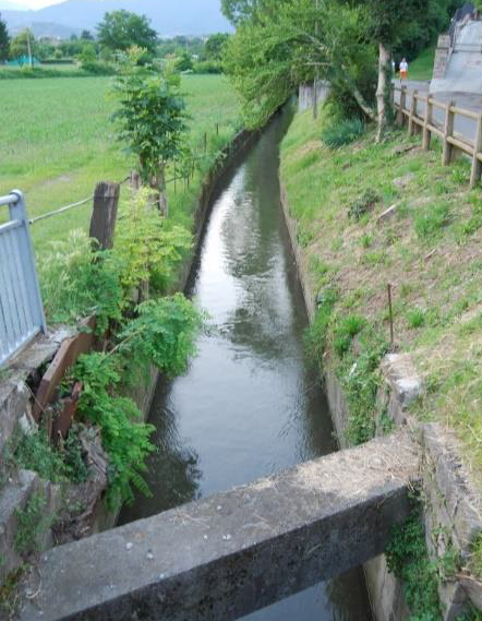
The Cherio River basin is located in the eastern part of Bergamo province, Lombardy region. It extends from the pre-alpine reliefs to the irrigated plain area, down to the confluence of Cherio River into Oglio River. The catchment area is about 153 km2, broken down mainly into forest (42%) and agricultural (39%) land. The territory is vulnerable to overflows and flooding events, which requires constant reclamation activities. Moreover, the increasing water withdrawals from Cherio River for industrial and agricultural purposes compromises the possibility to ensure environmental flows, especially during summer and drought periods. Pollution from nitrogen, phosphorus and wastewaters finally contributes to deteriorate the overall water quality.
OPTAIN seeks the involvement of local actors to identify strategies and solutions for an efficient water management, aimed at ensuring quali-quantitative standards to safeguard natural and aquatic habitats and to support an agricultural system deeply dependent on water resources.
OPTAIN seeks the involvement of local actors to identify strategies and solutions for an efficient water management, aimed at ensuring quali-quantitative standards to safeguard natural and aquatic habitats and to support an agricultural system deeply dependent on water resources.
Position
Latitude
45.7
Longitude
9.85
Biogeographical Region
Continental
Project
OPTAIN
National Id
IT_05
Implementation Status
Modeled
Contact
University of Milan, Dept. of Agricultural and Environmental Science
Photo gallery
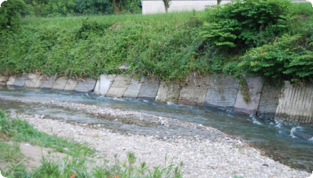
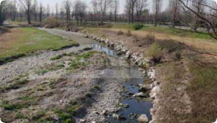
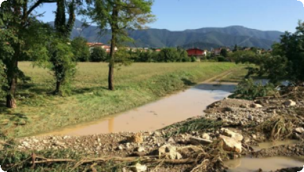
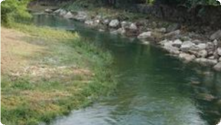
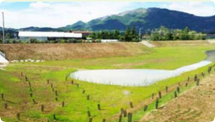
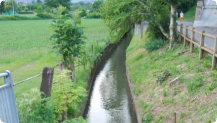
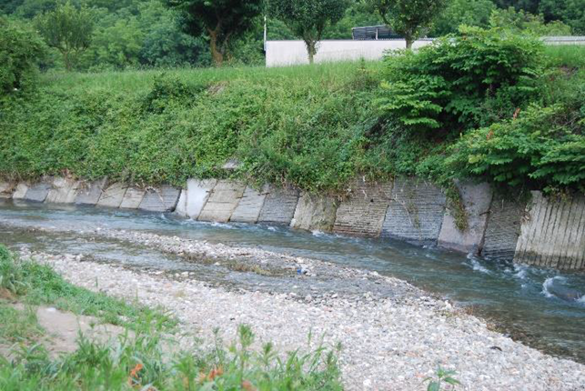


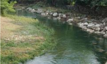
Location of the project
Cherio River Basin
NUTS Code
ITC4 - Lombardia
Sponge Measure(s) implemented in the case study
Involved Partners
| Authority type | Authority name | Role | Comments |
|---|---|---|---|
Climate
Climate zone
warm temperate moist
Annual Averages:
Precipitation
1200 mm/y
Temperature
min -12.3°, max 36.3°
Evapotranspiration
532 mm
Runoff
733 mm
Geography
Slope range
3.16% (agricultural land) - 47.04% (forest land). Average 22.27%
Soil type
Cambisol
Luvisols
Groundwater level
not applicable, few data available
Vegetation class
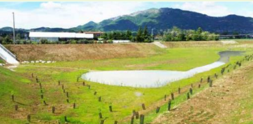
The case study area is mostly covered with forest vegetation in its upper part, while cropland dominates the lower (plain) part of the basin. Most of potential NSWRM are implemented on cropland or in marginal areas along watercourses, while terraces are concentrated in hill and mountain areas currently covered with forest/woodlands because they are largely abandoned and not well maintained. Vegetation cover changes thus depend on the type of NSWRM activated: it does not changes in case of drought-resistant crops; it changes to grassland in case of river restoration (i.e. wetlands) and to grass/shrubs/deciduous trees in case of riparian buffers, and assumed to change to permanent crops in the case of terraces. In case a pond is implemented, arable land changes to a pond
Water quality
Water bodies: Ecological Status
Natural surface waters (river and lake): poor or moderate
Water bodies: Chemical Status
Natural surface waters (river and lake): Falling to achieve good
Site Information Summary
Potential sites for the implementation of measures have been defined (allocation rules) in modelling.
Scale of the project
Project scale
Meso
Project scale specification
catchment scale modelling
Lifespan
2020-2025
Size of the project
Project area
153 km2
Area specifications
Rural/agricultural area covers nearly 40% of the catchment, forests covers ca. 42%
Design land use change
| Land use change type | Comment |
|---|---|
|
Other
|
Allocation rules envisage the possibility of land cover (from arable land to grassland) and land use changes (e.g. from woodlands to agricultural area) |
Design and implementation summary
N/A, no single measures are implemented at real sites.
Total cost
Total costs (implementation and maintainance) depends on the type of NSWRM and their potential individual location within the catchment
Financing authorities
| Authority name | Type of funding | Financing share | Comments |
|---|
Land ownership
Potential sites for the implementation of measures are on agricultural land (arable land), forest areas and marginal lands along watercourses. Land ownership varies across potential sites (either individually-owned (farmers/landowner)or collectively-owned
Community involvment
Yes
Design consultation activity
| Activity stage | Name | Key issues | Comments | |
|---|---|---|---|---|
|
Screening phase
|
MARG workshop
|
Stakeholders were involved throughout the project: farmers (represented by farmers union), land and water managemers (e.g. local reclamation and irrigation board), regional authorities (various DGs), local communities/associations.
|
Discussions about the POTENTIAL implementation of measures only
|
Policy target
| Target purpose | |
|---|---|
|
Pollutants Removal
|
|
|
Improved Biodiversity
|
|
|
Groundwater Recharge
|
Policy area
| Policy area type | Policy area focus | Name | Comments | |
|---|---|---|---|---|
|
Primary
|
Environmental Policy
|
|||
|
Primary
|
Common Agricultural Policy
|
|||
|
Primary
|
Nitrate Directive
|
|||
|
Primary
|
Water Policy - Floods Directive
|
|||
|
Primary
|
Forest Strategy
|
|||
|
Primary
|
Regional Policy
|
Part of wider plan
1
Wider plan type
| Wider plan type | Wider plan focus | Name | Comments |
|---|
Requirement directive
| Requirement directive | Specification | |
|---|---|---|
|
Water Framework Directive (WFD) 2000/60/EC
|
Policy challenges requirements
There has been an increase in severe droughts and extreme rainfall events, leading to floods in both urban and agricultural areas. The area is also suffering from pollution of both urban and agricultural origin.
Monitoring and Maintenance Summary
N/A, no single measures are implemented at real sites. If we refer to already implemented ones, info should be sourced elsewhere
WFD ecological status obj quantity
Natural surface waters (river and lake): poor or moderate
Success factor(s)
| Success factor type | Success factor role | Comments | Order |
|---|
Driver
| Driver type | Driver role | Comments | Order |
|---|---|---|---|
|
Organisation committed to it
|
main driver
|
Support availed and advisory services, farm structure and characteristics, farm ownership
|
Overall impact
Hopefully, the overall results of OPTAIN can serve as a decision support tool to stimualte the (wider) implementation of measures, overcoming bottlenecks and current weaknesses in this direction, and to contribute in drafting/providing policy guidelines.
Lessons learned Summary
N/A, no single measures are implemented at real sites.
The in-depth description of the case study