Last update
2025
Summary
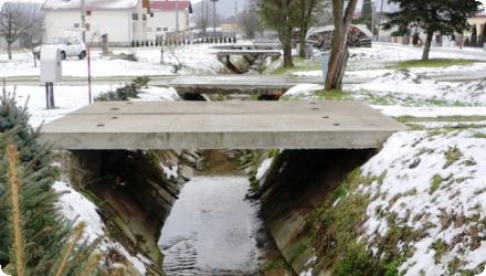
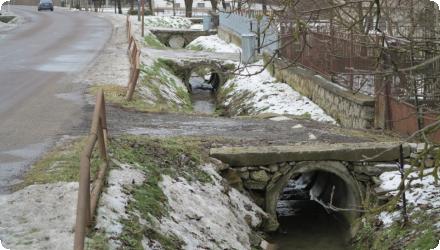
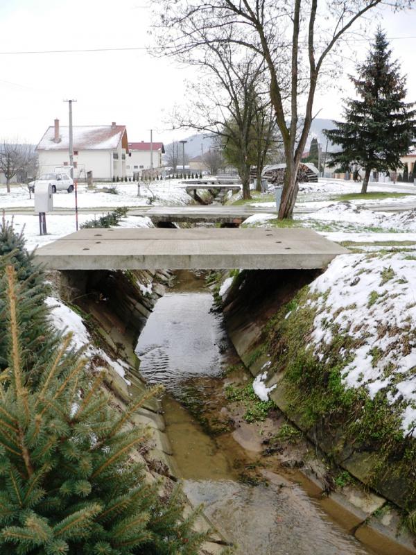
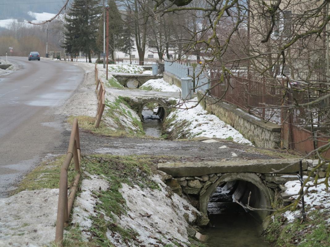
Integrated rainwater retention was applied to recover degraded landscapes and local climate in north-eastern Slovakia, using small check dams, retention ponds, rain gardens and re-cultivated logging roads. Coordinated by People & Water (Ľudia a voda) and co-financed by the LIFE programme (LIFE11 ENV/SK/001019), the project worked across the Ondávka micro-region (Humenné district; eight municipalities). Implemented from August 2012, it ended early in May 2015 after loss of co-financing. By closure, 1,148 small barriers, 7 rain gardens and ~1 km of logging roads had been built or re-profiled; planned fishponds were cancelled. Local reporting indicates the measures reduced flood peaks during intense storms in 2013–2014 and were estimated to enhance the “small water cycle” by ~140,000 m³/year. The project also created short-term jobs (e.g., 56 unemployed people engaged in 2013 via the Humenné Labour Office). Since 2015, similar water-retention approaches have been incorporated into regional plans (e.g., the Košice Region’s 2021–2030 landscape and river-basin restoration programme) and referenced in national flood-risk planning updates (2024) covering the area.
Position
Latitude
48.951
Longitude
21.916
Project
NWRM
National Id
Slovakia_06
Installation date
2015
Implementation Status
Contact
REC
RBD code
SK40000
Transboundary
0
Photo gallery

Location of the project
The case study is in the Ondavka micro-region (District Humenné, Prešov Region), across the municipalities Baškovce, Černina, Gruzovce, Hrubov, Ohradzany, Slovenská Volová, Sopkovce and Turcovce.
NUTS Code
SK04 - Východné Slovensko
Project's objectives
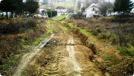
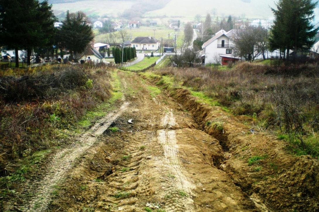
Integrated works to retain rainwater across eight Ondavka municipalities: re-cultivation of logging roads/paths, flow-control barriers, retention ponds, and rain gardens—to prevent excess runoff, floods, drought and erosion.
Planned outputs (LIFE plan, Action B.1): 20 retention ponds, 150 flow-control barriers, 35 rain gardens, and 7 km of re-cultivated logging roads.
Target hydrologic effect: confirm ~120,000 m³ of retained water (annual “small-water-cycle” gain) through monitoring.
Monitoring deliverables (C.1): monthly thermal images (≥6 per site), 48 monitoring documents, and networking with other LIFE projects.
Socio-economic objective: employ at least 80 local residents for one year as part of the works.
Involved Partners
| Authority type | Authority name | Role | Comments |
|---|---|---|---|
Climate zone
cool temperate moist
Temperature
8 °C
Precipitation
550
Annual rainfall range
300 - 600 mm
Elevation range
340
Vegetation class
Predominant class is forest land (~50.22%), with substantial permanent grassland (~29.75%) and arable land (~12.95%) across the 7,044 ha project area.
Water bodies: Ecological Status
Moderate
Water bodies: Chemical Status
Good
Project scale
Meso
Project scale specification
The project spans the Ondavka micro-region (Bodrog sub-basin, E. Slovakia) across eight municipalities : Baškovce, Černina, Gruzovce, Hrubov, Ohradzany, Slovenská Volová, Sopkovce and Turcovce ; implementing a distributed set of measures (small check dams, rain gardens, re-cultivated logging roads) at multiple sites within the sub-basin rather than a single point location.
Project area
7044
Total cost
€1,431,535
Costs total information
EU Contribution: 690267 €
PandW Contribution: 141288 €
Ondavka Contribution: 600000 €
Total elegible budget: 1380535 €
PandW Contribution: 141288 €
Ondavka Contribution: 600000 €
Total elegible budget: 1380535 €
Financing authorities
Type of funding
EU-funds: LIFE+
Comments
€690,267
Type of funding
Private funds
Comments
€141,288
Type of funding
Sub-national funds
Comments
€600,000
Policy context
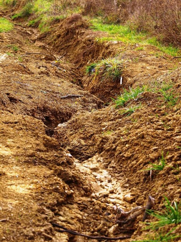
A damaged environment characterized by erosion, erosion furrows in agricultural lands, drought, flooding, quick rainwater runoff, low water retention capacity of soil, increasing rate of flow of water bodies near built up areas and deforestation.
Thinning atmosphere with higher allergenic content in the atmosphere and greater temperature oscillations between daytime and nighttime temperatures.
Thinning atmosphere with higher allergenic content in the atmosphere and greater temperature oscillations between daytime and nighttime temperatures.
Land ownership
Mixed ownership across the eight municipal cadastres.
Community involvment
Yes
Design consultation activity
| Activity stage | Name | Key issues | Comments |
|---|---|---|---|
|
Screening phase
|
Project presentations and their approvals at municipal gatherings
|
||
|
Introductory conference presenting project proposal
|
|||
|
Monitoring project output
|
|||
|
Other
|
Preparation and publication of manual
|
†œRevitalizing the Climate in my Community†
|
|
|
Other
|
Closing conference and dissemination of project results
|
Policy target
| Target purpose |
|---|
|
Increase Water Storage
|
|
Runoff control
|
|
Erosion Control
|
|
Oher Societal Benefits
|
|
Improved Biodiversity
|
Policy pressure
| Pressure directive | Relevant pressure |
|---|
Policy impact
| Impact directive | Relevant impact |
|---|
Requirement directive
| Requirement directive | Specification |
|---|
Contractual arrangements
0
| Arrangement type | Responsibility | Role | Name | Comments |
|---|
Part of wider plan
0
Wider plan type
| Wider plan type | Wider plan focus | Name | Comments |
|---|
The project itself says long-term monitoring is needed - especially rainfall measurement and water-level monitoring in the Ondavka - to validate hydrological and ecological effects.
Monitoring was run by two monitoring experts from the project team (NGO People & Water). They executed 14 missions (Sep 2013–Feb 2014) and 16 missions (Nov–Dec 2014), focusing on field inspections during and immediately after precipitation, mapping/photo documentation, and building a database of measures; Action C.1 was only partially completed because of the early termination.
Maintenance
No formal, published maintenance regime for the built measures is described; the LIFE record only notes a “high level of ownership” by the engaged municipalities, without detailing upkeep operations.
114 local long-term unemployed were trained and employed on site (56 people worked ~Aug–Dec 2013 after a training course on 1–9 Aug 2013; 58 people worked Apr–Sep 2014 in 8 teams across the 8 municipalities).
16 information boards installed; 1,500 + 1,500 bilingual leaflets printed; 4 press releases (of 8 planned) due to early close; project film broadcast 79 times on regional TV; website and multiple technical events/visits (e.g., NVE Norway) delivered.
16 information boards installed; 1,500 + 1,500 bilingual leaflets printed; 4 press releases (of 8 planned) due to early close; project film broadcast 79 times on regional TV; website and multiple technical events/visits (e.g., NVE Norway) delivered.
Greater attractiveness of the basin contributing to increased tourism
Information on retained water
Achieved 21,299 m³ one-off storage capacity; the team then estimated this at ~28,000 m³ considering additional infiltration during events, and ~140,000 m³ yr⁻¹ added to the local “small water cycle.”
Information on increased water storage
Rainwater retained more time on earth
Information on Increased groundwater level
No site measurements; the team estimates ~1/3 of annually retained water recharges groundwater (the rest evapotranspires).
Information on Reducing flood risks, quantity
After measures were in place (2013–2014), heavy rains reportedly did not cause the earlier recurrent flooding in target communes; check dams “had a big flood-prevention effect.”
Information on Restoring hydraulic connections
Planned fish/retention ponds were cancelled for financial reasons (so no new off-channel water bodies).
Water quality overall improvements
N/A info
Ecosystem impact climate regulation
Impact on GHGs (net emissions and storage) including soil carbon
Information on Ecosystem impact climate regulation
The project fills groundwater sources, feeds vegetation, and increase evaporation so revitalizes the small hydrological cycle and maintain a stable climate.
Information on Increased Evapotranspiration
Via enhanced evapotranspiration, the team estimates ~93,000 m³ yr⁻¹ evaporated, corresponding to a ~65 GWh yr⁻¹ reduction of sensible heat released to the atmosphere (cooling effect); also anticipates higher photosynthesis and carbon sequestration. These are project estimates, not direct measurements.
Key lessons
Retaining rainwater locally with many small, low-cost measures across a micro-basin can curb rapid runoff and reduce flood peaks. In Ondavka, check dams and rain gardens coincided with heavy rains in 2013–2014 without the earlier recurrent flooding, and works delivered ~21–28 thousand m³ of event storage with an estimated ~140 thousand m³ yr⁻¹ added to the small water cycle (project figures).
“The retention of rainwater on earth allows water to carry out its numerous unique functions which support various forms of life on earth. Water maintains a stable climate and a healthy hydrological cycle. Water is essential for evaporation which transforms the solar radiation into latent heat and thus contributing to a cool and stable climate. Without water, the solar energy is released back into the atmosphere as sensible heat therefore contributing to a rising temperature and drier atmosphere. An atmosphere abundant in moisture content maintains a stable and cool climate mitigating weather extremes such as drastic temperature oscillations, heat waves and intensive precipitation.”
Strong community engagement matters. Training and employing local long-term unemployed built capacity and ownership in the eight municipalities, which the project cites as key to rapid deployment and care of dispersed structures.
Funding continuity is a risk to delivery. Loss of co-financing led to early termination and cancellation of planned ponds; phasing and diversified budgets would help safeguard critical outputs.
Monitoring must be designed, funded, and sustained. The project planned thermal imaging and systematic hydrometric tracking but only partial monitoring was completed; future efforts should secure rainfall gauges, stream level/flow records, and standardized field inspections to verify long-term hydrologic, ecological, and climate effects.
Scaling is feasible but coordination is essential. Mixed land ownership and multi-municipality footprints require early permits, clear roles, and simple, maintainable designs; the approach has since informed wider regional programs.
Success factor(s)
| Success factor type | Success factor role | Comments | Order |
|---|---|---|---|
|
Communication activities
|
secondary factor
|
3
|
|
|
Financing possibilities
|
main factor
|
1
|
|
|
Successful coordination between authorities
|
secondary factor
|
2
|
Driver
| Driver type | Driver role | Comments | Order |
|---|---|---|---|
|
Organisation committed to it
|
main driver
|
1
|
|
|
Past flooding events
|
secondary driver
|
2
|
Transferability
Highly transferable to small sub-basins with similar topography and land use. Success depends on early municipal/landowner buy-in, clear permits, and stable co-financing. Design simple, maintainable check dams/rain gardens sized to local rainfall, soils and slopes; plan for sediment management and safe overflows. Build a minimal monitoring scheme (rain, water levels, inspections) and assign clear upkeep responsibilities.
English