Last update
2025
Summary
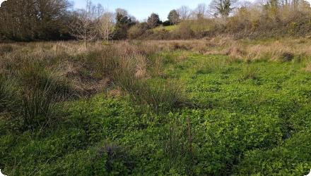
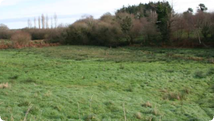
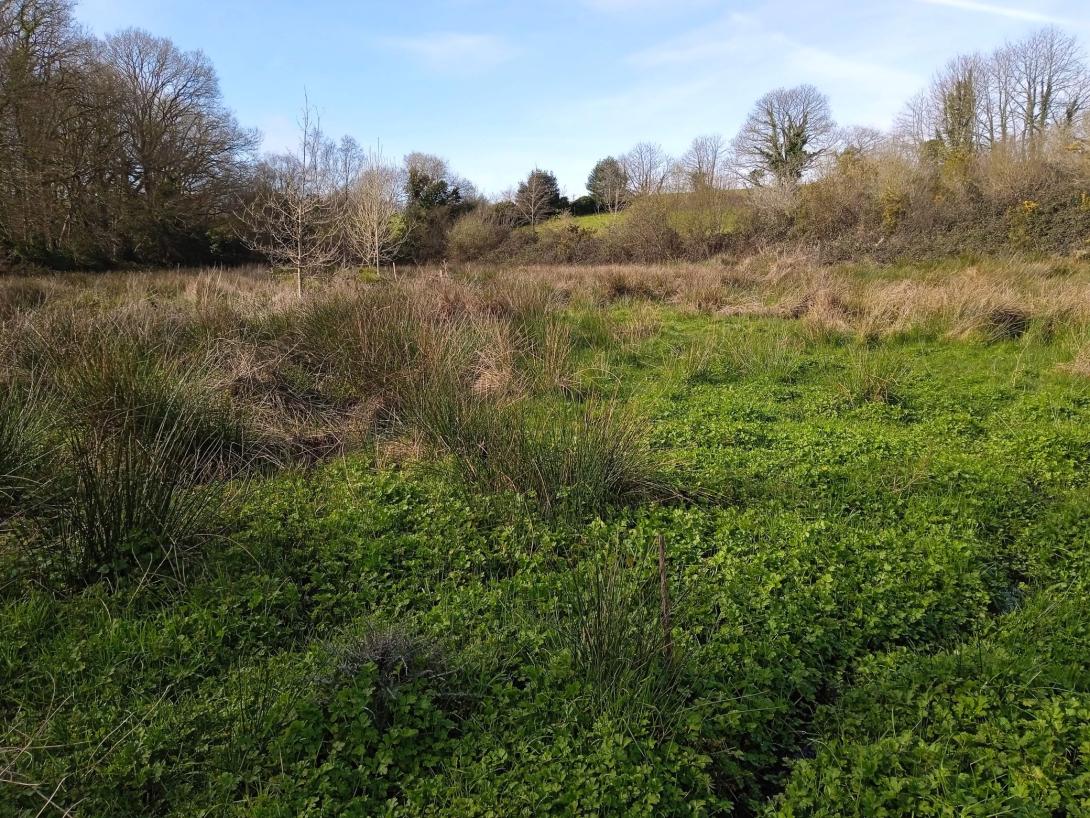
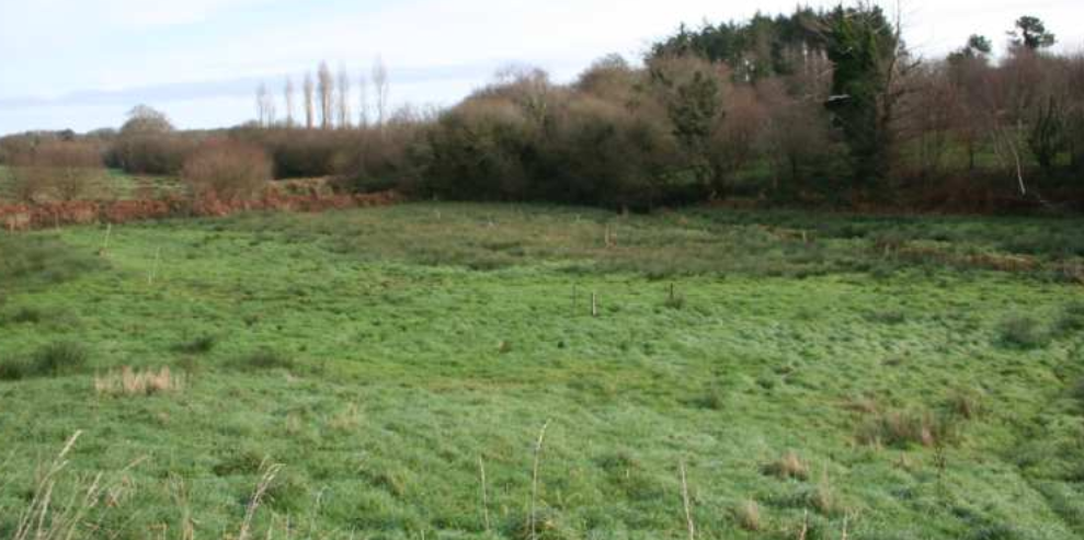
Headwater wet meadow (Saint-Évarzec, Finistère) where two drainage ditches short-circuited a hillside spring and routed nitrate-rich flows directly to the stream. In 2014, the ditches were infilled (north ditch partly to keep upstream runoff entering the meadow) and a small berm removed, with protected-species precautions. The short-circuit was eliminated: all slope water now crosses the wetland, maintaining high N removal; soil saturation increased and low-water levels rose slightly near the former ditch. Agricultural operability decreased (bearing capacity), so mowing is now feasible only in very dry years; the plot is used within a Brittany “pie-noir” grazing circuit.
However, the potential for agricultural exploitation since implementation is not as high as hoped, unlike the very satisfying hydrological effect : the meadow remans wet even during very dry years like 2022. The peaty wet part of the site is intentionally left to natural woodland succession (hoping for future understorey grazing), as it is not suitable for agricultural use otherwise.
The project owner/operator is the Communauté de communes du Pays Fouesnantais with RERZH technical support and monitoring. The costs were very low, an excavator hire for ~€560 and the rest of the works costs were included in the collectivity's budget (studies/monitoring covered by RERZH).
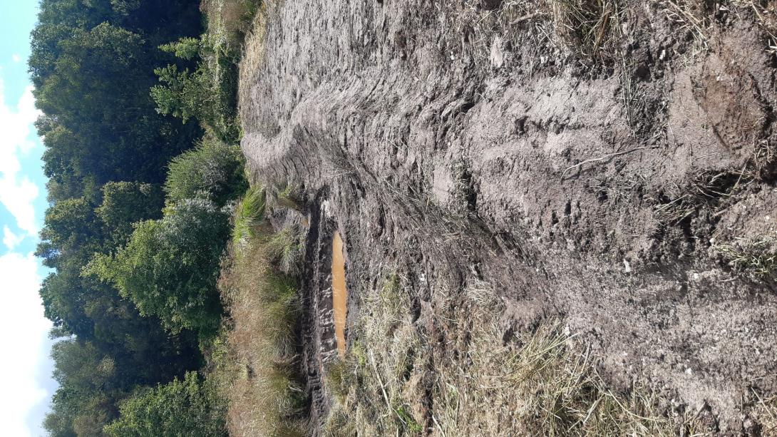
More recently, after the initial over-excavation and reuse of oxidised berms diverted part of the spring toward the southern sector, increasing waterlogging and limiting mowing, a corrective package created a small pond at the spring with overflow toward the peatier/northern side, resumed brush-cut mowing to restore a haying dynamic, and reinforced invasive nutria control in 2024.
However, the potential for agricultural exploitation since implementation is not as high as hoped, unlike the very satisfying hydrological effect : the meadow remans wet even during very dry years like 2022. The peaty wet part of the site is intentionally left to natural woodland succession (hoping for future understorey grazing), as it is not suitable for agricultural use otherwise.
The project owner/operator is the Communauté de communes du Pays Fouesnantais with RERZH technical support and monitoring. The costs were very low, an excavator hire for ~€560 and the rest of the works costs were included in the collectivity's budget (studies/monitoring covered by RERZH).
More recently, after the initial over-excavation and reuse of oxidised berms diverted part of the spring toward the southern sector, increasing waterlogging and limiting mowing, a corrective package created a small pond at the spring with overflow toward the peatier/northern side, resumed brush-cut mowing to restore a haying dynamic, and reinforced invasive nutria control in 2024.
Position
Latitude
47.942016
Longitude
-3.984766
Project
NWRM
National Id
France_12
Installation date
2014
Implementation Status
Contact
Forum des Marais Atlantiques – FMA
RBD code
FRG-La Loire, les cours d'eau côtiers vendéens et bretons
Transboundary
0
Photo gallery
Location of the project
The Coat Carriou site is located at the head of a small coastal river in South Finistère. The site occupies the right bank of the stream, in a relatively steep valley. The plot is occupied by a meadow. The other surrounding plots are meadows and crops, and a wooded hillside on the other side. The plot was acquired shortly before the project by an organic farmer who wanted to integrate it into his grazing land.
NUTS Code
FR52 - Bretagne
Project's objectives
Restore natural hydraulic functioning; optimise nitrogen removal (denitrification) by raising groundwater; favour typical wetland flora/fauna; maintain agricultural use (grazing/fodder quality); produce a demonstrator for stakeholders.
Involved Partners
| Authority type | Authority name | Role | Comments |
|---|---|---|---|
Climate zone
cool temperate moist
Temperature
12.5 °C
Annual rainfall range
900 - 1200 mm
Elevation range
77 m
Vegetation class
Hydrophilic meadow; 72 taxa recorded; Juncus effusus abundant.
Water bodies: Ecological Status
Good
Water bodies: Chemical Status
Good
Water quality status
High nitrate in inflow waters (up to 44 mg NO₃⁻/L) at the foot-slope resurgence.
Project scale
Micro
Project scale specification
single plot intervention
Project area
0.3 ha
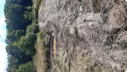
Infill of drainage network (ditches ~0.8–1.2 m deep).
Method: excavator on wide tracks; re-use of historic spoil berms for core; curates/”vases” placed on top; sod/horizon replaced; pre-felling of vegetation; stepwise topsoil removal from downstream to upstream to let small mammals escape; culverts blocked but kept for machinery passage.
Partial infill of the northern ditch to allow upstream parcel runoff to reach the meadow; small embankment removed; sensitive micro-habitats (Triton palmé) avoided.
2024 corrective measure: small pond created at the spring with overflow directed to the peatier/northern side to restore intended flow partition; coypu control; brush-cutting (gyro-mowing) to re-enable haying dynamics on part of the site.
The plot is located in a very hydromorphic valley bottom. Very wet even with prior drainage; thin peat; hillside spring; after works, southern part became too waterlogged for mowing except in very dry years.
With the objective of improving water quality in a watershed under nitrogen pressure, it was necessary to restore the purification function of the wet grassland by removing drainage ditches to restore water flow through the wetland and raise the water table.
Total cost
€560
Financing authorities
Type of funding
Sub-national funds
Type of funding
Local funds
Comments
local community budgets in territorial contracts
Policy context
The plot is located in a very hydromorphic valley bottom, whose groundwater level is influenced by both flows from the hillside and the watercourse. It drains to a marine area sensitive to algal blooms and the concentration of nitrogen in the water is high.
Originally a light peat bog (thin layer of peat), the plot was drained to reduce hydromorphy and thus allow the entry of machinery to exploit the meadow by mowing. Drainage is provided by two ditches 80 to 120 cm deep that collect water from a spring and drain the groundwater from the hillside. The groundwater level is relatively high despite this drainage, due to the double supply from the hillside and from the accompanying groundwater of the river.
As a result, the prairie vegetation is hydrophilic. Botanical inventories carried out in 2014 by the National Botanical Conservatory of Brest made it possible to obtain a mapping of habitats and a list of 72 taxa present. The Soft Rush (Juncus effusus) is present in large quantities.
Faunal inventories carried out by Bretagne Vivante and the Breton Mammological Group have revealed the presence of Palmate Newt (Lissotriton helveticus), Common Toad (Bufo spinosus) and Grass Frog (Rana temporaria). Five odonata species have been observed, including the Golden-ringed Dragonfly (Cordulegaster boltonii), a key species at the departmental level. Eleven species of orthopterans have been observed on the site, as well as the Mole Cricket (Gryllotalpa gryllotalpa), rare in Bretagne. Two protected semi-aquatic mammals are using the site: the Southern Water Vole and the Eurasian Water Shrew.
The watershed is subject to nitrogen pressure. The water reaching the meadow by resurgence at the foot of the hillside can reach concentrations of 44 mg/l of nitrates upstream of the plot. These decrease significantly as they flow into the plot, indicating that nitrogen has been reduced in the wetland. As a result of prairie drainage, some of the water enters the stream without passing through the wet meadow and its purification capacity is therefore partially short-circuited.
Land ownership
Private organic farmer (Mr. Guillou); plot integrated to grazing circuit (Brittany pie-noir herd).
Community involvment
No
Design consultation activity
| Activity stage | Name | Key issues | Comments |
|---|
Policy target
| Target purpose |
|---|
|
Pollutants Removal
|
|
Improved Biodiversity
|
Target Remarks
The objective of the NWRM is to restore hydraulic operation of the meadow to allow:
- optimize nitrogen abatement processes by denitrification by raising the groundwater level;
- to improve forage quality by controlling the diffuse rush with appropriate management;
- to promote a fauna and flora typical of wetlands;
- to demonstrate to the stakeholders of the territory the interest of this type of restoration for the improvement of water quality.
Policy pressure
| Pressure directive | Relevant pressure |
|---|
Policy impact
| Impact directive | Relevant impact |
|---|
Requirement directive
| Requirement directive | Specification |
|---|
Contractual arrangements
1
| Arrangement type | Responsibility | Role | Name | Comments |
|---|---|---|---|---|
|
Other
|
Agreement with the farmer and landowner, to allow the measure implementation.
The land is supposed to remain usable for the farmer's activities. |
Part of wider plan
0
Wider plan type
| Wider plan type | Wider plan focus | Name | Comments |
|---|
The follow-ups implemented were carried out from 2014 (before the works) to 2016.
Piezometric monitoring : 3 transects of 5 piezometers each placed in the direction of the steepest slope of the site, with a water level reading every 15 days.
Physico-chemical monitoring : The evolution of nitrogen concentrations in the water table across the wetland was measured by taking water from the piezometers.
Ecological monitoring : Two transects were carried out on the plot to monitor the evolution of the flora. A mapping of the vegetation of the plot is also carried out. Qualitative inventories of amphibians, lepidoptera, orthoptera and odonates have been carried out.
Control site : Monitoring is also carried out on a similar control site in a good state of conservation. The control plot is located upstream on the same watercourse.
Maintenance
Extensive grazing planned; mowing where feasible; invasive mammal control (nutria).
Before/after vs. control site (hydrology, water chemistry, vegetation, fauna), with formal protocols from the RERZH programme.
Information on increased water storage
Over-excavation and reuse of oxidised berm material led to a slight over-deepening of banks and unintended diversion of spring flow to the southern sector; this intensified waterlogging and reduced bearing capacity, making mowing largely unfeasible, site management (mowing/pasture) stalled, with vegetation closure trends. A 2024 corrective work package re-shaped the spring area (small pond with overflow toward the intended, peatier/northern side), reinstated management (gyro-mowing).
Information on Increased groundwater level
Visual observations on site show a greater saturation of soil water on the southern part of the plot. This remained saturated throughout 2016, making mowing impossible, whereas it was before the ditches were filled.
Piezometric levels at low water level after work are slightly higher (10 centimetres on average) in the piezometers closest to the filled ditch, but this observation is not statistically significant. In addition, the same phenomenon can be observed at the control site, showing a variation more related to meteorology. However, on the restored site, there is an increase in the restoration date and a decrease in the discharge period, showing an increase in the saturation time of the wetland soil.
In the absence of a piezometer in the area where a groundwater rise was observed visually, it could not be quantified.
Information on Water quality overall improvements
Inflow nitrate up to 44 mg/L; across-wetland drop to below detection within 10–20 m both before and after works.
Main gain from works: elimination of the short-circuit : now all hillside flows traverse the wetland and benefit from its full purification capacity; slight rise in orthophosphate still within “good” WFD thresholds and also seen at control.
Main gain from works: elimination of the short-circuit : now all hillside flows traverse the wetland and benefit from its full purification capacity; slight rise in orthophosphate still within “good” WFD thresholds and also seen at control.
Information on Soil quality overall soil improvements
The reduction of dissolved mineral and organic nitrogen after the work is maintained. The same trend can be observed at the control site, and the difference between the two sites is not statistically significant. There is no observed effect of the work on orthophosphates.
These results show that the wetland was already functional before restoration in terms of nitrogen purification.
These results show that the wetland was already functional before restoration in terms of nitrogen purification.
1
Vegetation evolved between 2014 and 2016 in some areas of the plot, with the appearance of more hygrophilic species in the old ditches and downstream of the plot. In addition, the recovery of some species such as the Sharp-flowered Rush has increased significantly over the entire profile studied. There is also an increase in the average number of species per quadrat, indicating a diversification of the existing grassland. Many species of acidophilic lowland and paratourous grassland have been identified, representing a gain in terms of heritage species.
The work begun in the summer of 2014 seems to have been favourable to the Grass Frog, which immediately exploited the new temporary puddles available. The second year of prospecting confirms this colonization of the site by the species.
Orthopteran processions linked to wetlands (Conocephalus dorsalis, Gryllotalpa gryllotalpa, Chorthippus albomarginatus, Stethophyma grossum, Tetrix ceperoi...) are well preserved with little evolution between before and after work because the vegetation already had a very marked wet grassland character before work.
The Southern Water Vole is still present in high density on the site in 2015. By 2016, the occupation of the northern ditch had decreased significantly, especially in the area between the former central ditch and the watercourse, where the nutria has become well established. A nutria control campaign launched by the CCPF in 2016 should make it possible to avoid the continuation of the replacement of the Vole by this species.
There is no detected impact on the Eurasian Water Shrew. Vegetation trending to more hygrophilous/peaty assemblages 2014→2016; 2020 notes reduced cover of Juncus acutiflorus and rise of J. effusus linked to lack of management access.
Nutria proliferation required control campaigns.
Key lessons
It would have been interesting to measure the flow rates and nitrogen contents in the ditch water to quantify the gain provided by the removal of these short circuits. The restoration works have increased the duration of soil water saturation in the monitored area, and visual observations indicate a groundwater rise in the downstream part of the plot. The monitoring conducted does not allow for a significant demonstration of the restoration’s effect on biogeochemical processes. Physicochemical monitoring shows that the wetland was already biogeochemically functional in the presence of drainage ditches, due to the specific nature of its water supply. The main benefit of the restoration work was the elimination of the shortcutting effect of the ditches. After the intervention, all water coming from the hillside now flows through the wetland and benefits from its natural purification function. It would have been useful to measure flow rates and nitrogen compound concentrations in the ditch water in order to quantify the improvement achieved.
Removing ditch short-circuits can be decisive for water quality even when pre-existing purification is high; quantify ditch flows and loads if a more “demonstrative” N-removal gain is required. Manage the trade-off between hydrologic restoration and agricultural operability; plan for adaptive corrections and for invasive species control.
Removing ditch short-circuits can be decisive for water quality even when pre-existing purification is high; quantify ditch flows and loads if a more “demonstrative” N-removal gain is required. Manage the trade-off between hydrologic restoration and agricultural operability; plan for adaptive corrections and for invasive species control.
Success factor(s)
| Success factor type | Success factor role | Comments | Order |
|---|---|---|---|
|
Existing staff and consultant knowledge
|
main factor
|
Subsidies and programme support (technical + monitoring) lower barriers and provide evidence |
|
|
Successful coordination between authorities
|
secondary factor
|
Alignment with farmer’s grazing goals helps acceptance |
Driver
| Driver type | Driver role | Comments | Order |
|---|---|---|---|
|
Availability of subsidies
|
main driver
|
The subsidies helped convincing the local community to invest in the project.
|
|
|
Other
|
main driver
|
The land owner was willing to include the meadow in the grazing path of his herd and was therefore interested in improving the fodder quality by reducing the Juncus effusus and not too sensitive to a loss of bearing capacity of the meadow.
|
Transferability
Highly transferable to drained wet meadows at headwaters under nitrate pressure; ensure (i) careful re-grading to avoid unintended flow redirection, (ii) early invasive mammal management, and (iii) access for continued mowing/grazing or accept land-use shifts.
Cost effectiveness
Very low direct works cost (hundreds of euros) for strong hydrologic/water-quality benefits; agricultural utility of the plot may decrease without adaptive design/management, potentially requiring corrective works.
English