Last update
2025
Summary
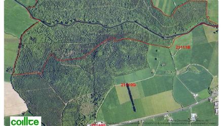
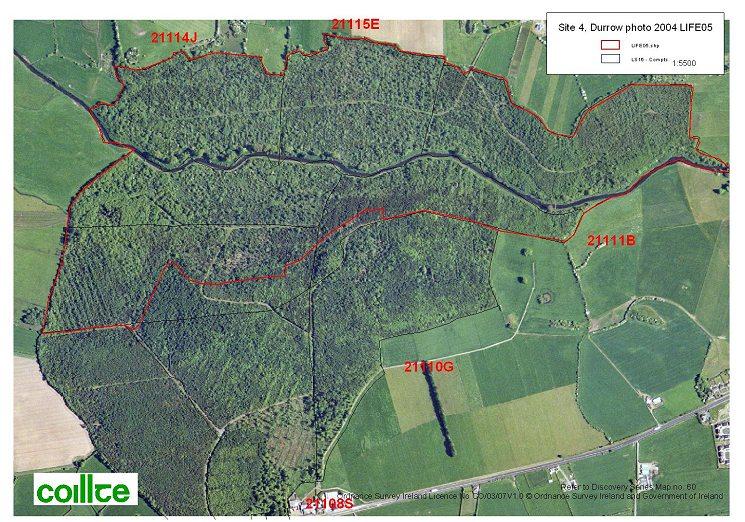
This site was one of nine included in the LIFE05 project to restore priority woodland habitats in Ireland. The Durrow site lies on the floodplain of the River Erkina and had been affected by planting of non-native conifers and associated drainage. A network of shallow ditches across the site was reducing the retention time of floodwaters; to counter this, c.350 ditch-dams were installed (installation 2009, LIFE05/NAT/IRL/000182). Since then, Durrow has been confirmed as part of the River Barrow & River Nore SAC (002162), where alluvial forests (91E0*) are a qualifying interest; assessments also record calcareous “petrifying springs” (7220*) within the alluvial woodland along the Erkina floodplain, and describe Durrow as one of the largest remaining alluvial woodlands in Ireland. At catchment scale, EPA WFD characterisation shows the downstream waterbody ERKINA_050 declined from Good to Moderate status with elevated phosphate and agriculture as a significant pressure, framing ongoing risks to riparian habitats. Nationally, Coillte’s LIFE05 programme restored >550 ha of priority native woodlands across nine Natura 2000 sites (including Durrow). Locally, the Durrow Biodiversity Action Plan 2023–2028 highlights the Erkina, the Nore and associated woodlands within the SAC.
Position
Latitude
52.8518
Longitude
-7.412983
Project
NWRM
National Id
Ireland_02
Installation date
2006–2009
Implementation Status
RBD code
IESE
Transboundary
0
Photo gallery
Location of the project
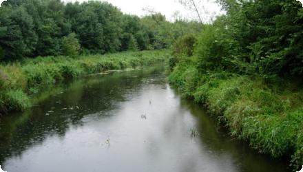
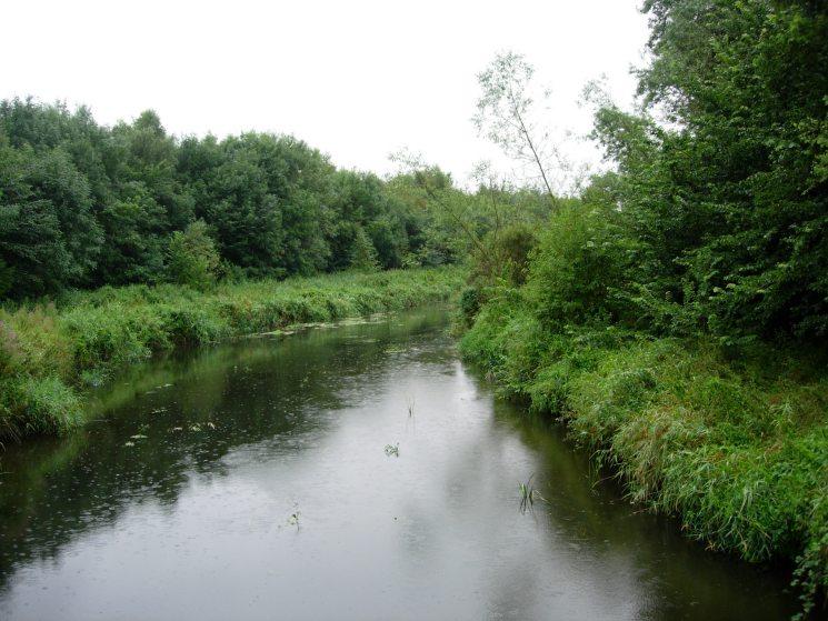
The site is located on the floodplain of the River Erkina, which is a tributary of the River Nore, in southeast Ireland.
NUTS Code
IE02 - Southern and Eastern
Project's objectives
Restore 95 ha of Annex I alluvial woodland.
Block 350+ drains to raise water table.
Remove non-native species across the site.
Promote regeneration of native wet woodland vegetation.
Block 350+ drains to raise water table.
Remove non-native species across the site.
Promote regeneration of native wet woodland vegetation.
Involved Partners
| Authority type | Authority name | Role | Comments |
|---|---|---|---|
Climate zone
cool temperate moist
Temperature
10
Precipitation
1000
Annual rainfall range
900 - 1200 mm
Elevation range
87 m
Slope range
0-1%
Vegetation class
Riparian alluvial woodland dominated by native wetland species (e.g., alder, willow).
Water bodies: Ecological Status
Moderate
Water bodies: Chemical Status
Unknown
Water quality status
In sub-catchment Nore_SC_050, water body ERKINA_050 declined to Moderate status with elevated phosphate; likely pressures are agriculture and hydromorphology from drainage district works.
Project scale
Micro
Project scale specification
The Durrow project restored 95 hectares within a larger 550.8-hectare national LIFE programme. It focused on one Natura 2000 site, indicating a site-level but impactful intervention.
Performance timescale
1 - 4 years
Project area
95
Area specifications
Entire area subject to hydrological and vegetative intervention (e.g., damming, planting, invasive removal).
Lifespan
Long-term/permanent, assuming natural woodland regeneration is maintained and invasive species remain controlled.
Restoration followed EU Habitats Directive guidance, aiming to re-establish natural hydrology and native species composition in a degraded alluvial forest. The approach prioritized ecological integrity, minimal intervention where possible, and natural regeneration. Public awareness and long-term sustainability were integral to the design.
Designed for seasonal water retention, not extreme storm events. Aimed to mimic natural floodplain dynamics, not meet specific engineered storm thresholds. The measures are designed to restore the alluvial woodland habitat by holding water on the floodplain for longer.
The measures are designed to hold back water and increase water levels in the alluvial woodland, increasing retention time on the floodplain. There is no specific design capacity.
Design capacity description
The measure aimed to rewet drained soils to raise the water table, reduce runoff, and promote seasonal inundation compatible with wet woodland species. Hundreds of peat and timber dams were installed to control flows without artificial regulation. The natural floodplain's retention potential was harnessed rather than engineered.
Providing the desire/intention is to restore habitat upstream and there are no areas local to the drainage that should not be put at risk of higher water levels, there are no constraints to this type of measure.
These measures could be applied anywhere that woodland or other habitat has been drained, although the details of the approach will vary depending on the soil type (in this case, alluvial deposits). Existing semi-natural topography, low gradient, flood-prone landscape, and remnant native vegetation enabled successful hydrological restoration.
Positive influence effectiveness
Natural hydrological potential for the restoration of wet woodland.
Negative influence effectiveness
Prior drainage and conifer plantations.
Total cost
€2,595,000
Costs investment information
The total LIFE project cost was 2.284 million euros, which was spread across 9 sites. No information has been obtained about the distribution between sites or the costs specifically attributable to the relevant hydrological measures.
Costs land acquisition information
No land aquisition was needed.
Costs operation maintenance information
Ongoing monitoring and maintenance was planned in an "After LIFE Conservation Plan"
Costs disposal decommissioning information
Not relevant as it is a permanent restoration.
Financing authorities
Type of funding
EU-funds: LIFE+
Comments
EU-LIFE05
Type of funding
Private funds
Compensations
0
Compensation remarks
No compensation was required, as the land was already owned or managed by Coillte (state forestry company).
Policy context
The main driver for the work was deterioration of priority habitat, due to planting of non-native conifers and drainage. The drainage meant that floodwaters were not being retained on the floodplain.
Land ownership
Coillte Teoranta (the Irish Forestry Board) owns the Durrow alluvial woodland and implemented the works.
Community involvment
Yes
Design consultation activity
| Activity stage | Name | Key issues | Comments |
|---|---|---|---|
|
Implementation phase
|
Interpretation boards
|
Two interpretation boards at Durrow
|
|
|
Screening phase
|
Project website
|
Set up at project commencement and updated through the project and with final deliverables
|
|
|
Implementation phase
|
Production of project brochures
|
Introductory brochure produced early in the project, with a final results brochure on completion. Hard copies printed for dissemination locally and internationally
|
|
|
Implementation phase
|
Annual "woodland walk"
|
Held annual during the project duration at three demonstration sites (although Durrow was not one of them)
|
|
|
Screening phase
|
Public consultation meetings
|
In total eight events in year 1, 20 in year 2, 14 in year 3 and seven in year 4
|
|
|
Implementation phase
|
End of project conference
|
Policy target
| Target purpose |
|---|
|
Improved Biodiversity
|
Target Remarks
Reinstate natural hydrology. Improve floodplain biodiversity, enhance water retention, reduce flood risk, and increase public awareness. Restoration was designed around ecological and hydrological targets aligned with EU conservation obligations, while also producing co-benefits for water management.
Policy pressure
| Pressure directive | Relevant pressure |
|---|---|
|
WFD identified pressure
|
Hydromorphological degradation
|
|
WFD identified pressure
|
Poor ecological status
|
|
Floods Directive identified pressure
|
Increased runoff due to drainage
|
|
Other EU
|
Habitats Directive: Unfavourable conservation status of Annex I habitats.
|
Pressures remarks
Related WFD pressures include hydromorphological alterations and nutrient pressures from past land use.
Policy impact
| Impact directive | Relevant impact |
|---|---|
|
WFD identified impact
|
Supports good ecological status via wetland restoration.
|
|
Floods Directive identified impact
|
Helps mitigate localized flood risk by restoring flood retention functions.
|
|
Other EU
|
Habitats Directive: Contributes to Favourable Conservation Status of 91E0 habitat.
|
Impact remarks
Though biodiversity-focused, the project has tangible water regulation and flood prevention impacts aligned with EU water policy goals. The project directly mitigates habitat loss and altered floodplain dynamics through nature-based solutions.
Requirement directive
| Requirement directive | Specification |
|---|
Requirement directive remarks
The project meets cross-directive goals through a synergistic, site-based nature restoration strategy.
Policy challenges requirements
Managing invasive species; long-term habitat management and public engagement.
Contractual arrangements
0
| Arrangement type | Responsibility | Role | Name | Comments |
|---|
Part of wider plan
1
Wider plan type
| Wider plan type | Wider plan focus | Name | Comments |
|---|---|---|---|
|
Environment & Biodiversity
|
LIFE project LIFE05 NAT/IRL/000182
|
The title of the LIFE project was "Restoring priority woodland habitats in Ireland". It covered 9 sites, with the Natural Water Retention Measure installations at one site (Durrow).
|
|
|
National
|
Environment & Biodiversity
|
National Biodiversity Plan (Ireland)
|
Durrow aligns with national targets for woodland recovery.
|
Water level monitoring in dipwells. Vegetation monitoring by quadrat surveys and aerial imagery. No monitoring in adjacent river.
Maintenance
Ongoing control of invasive species and maintenance of dams/fences.
Edge of Field/Plot
Dipwells were installed at the start of the project, which were used to inform the requirements for measures, as a result of which coffer dams were installed on ditches. Dipwell monitoring was continued after installation. Photographic documentation is also used.
Water table monitoring and vegetation plots.
Enhanced flood mitigation downstream.
Creation of employment through site works (damming, tree removal).
Increased eco-tourism and education via trails and interpretive signage.
Increased eco-tourism and education via trails and interpretive signage.
Hydrological effects
Restoration of seasonal inundation patterns; raised water tables; stabilized floodplain hydrology.
Information on retained water
Water is retained through blocked drains and re-wetted soils; quantified volumes not provided.
Information on runoff reduction
Qualitative reduction in runoff due to water retention by floodplain and rehydrated soils.
Information on Reducing flood risks, quantity
Reduced via water retention on-site, delayed runoff, and restored floodplain buffering.
Information on Restoring hydraulic connections
Ditch-blocking reconnected floodplain to river hydrology, enhancing lateral water movement across site.
1
Along with other measures in the project (removing non-native species), damming the ditches allows the alluvial woodland habitat to be restored.
Significant habitat restoration of Annex I alluvial woodland.
Native wet woodland species (e.g. alder, willow) recolonized.
Enhanced bird, insect, and understory flora diversity.
Specific species/community indexes not given, but high biodiversity gains confirmed through vegetation surveys.
Significant habitat restoration of Annex I alluvial woodland.
Native wet woodland species (e.g. alder, willow) recolonized.
Enhanced bird, insect, and understory flora diversity.
Specific species/community indexes not given, but high biodiversity gains confirmed through vegetation surveys.
Ecosystem impact climate regulation
No specific impact
Information on Increased Evapotranspiration
Likely increased due to more vegetation cover and soil wetness, but no quantified value.
Other Biophysical impacts
Enhanced microclimate regulation and re-establishment of natural successional processes in riparian zones.
Information on Ecosystem provisioning services
Negative: loss of timber production from conifer plantations.
Positive: water supply regulation via improved retention and delayed runoff.
Positive: water supply regulation via improved retention and delayed runoff.
Key lessons
Main lessons taken from this site (and the project as a whole included):
- Pre-implementation monitoring was crucial to determine appropriate actions, such as installing over 350 dams to restore hydrology.
- Public engagement ensured community understanding and support for the measures.
- Stakeholder attitudes and communication activities were significant success factors.
Success factor(s)
| Success factor type | Success factor role | Comments | Order |
|---|---|---|---|
|
Communication activities
|
main factor
|
These included signs, guided walks, and outreach for schools and visitors. They were key to local understanding. |
1
|
|
Financing possibilities
|
main factor
|
Made possible by access to LIFE Nature and matching national funds. |
2
|
|
Attitude of relevant stakeholders
|
main factor
|
Coillte collaborated actively with government agencies and NGOs. |
3
|
|
Attitude of decision makers
|
main factor
|
Proactive. The Forest Service supported the project and provided monitoring via the National Forest Inventory. |
4
|
|
Existing institutional framework
|
secondary factor
|
Clear and functional partnership among Coillte, NPWS, Forest Service, and Woodlands of Ireland. |
5
|
Driver
| Driver type | Driver role | Comments | Order |
|---|---|---|---|
|
Organisation committed to it
|
main driver
|
The project took place as a result of Coillte's commitment to restoring priority habitats
|
1
|
Flexibility adaptability
The type and location of dam structures were adjusted based on site-specific data (hydrology, topography, vegetation). Flexibility was also shown in species selection, favouring alder, willow, ash, or birch depending on micro-site water conditions.
Transferability
The project is highly transferable to other sites with degraded alluvial forests due to drainage or forestry intensification, hydromorphic or organic soils, possible hydrological connectivity with nearby rivers or floodplains.
Factors that complicate transfer : Dependence on EU funding (e.g. LIFE), not always available elsewhere. Land use change (e.g. abandoning intensive forestry) may be harder to justify or negotiate on private lands than public land ownership here with Coillte.
Factors that complicate transfer : Dependence on EU funding (e.g. LIFE), not always available elsewhere. Land use change (e.g. abandoning intensive forestry) may be harder to justify or negotiate on private lands than public land ownership here with Coillte.
Basin characteristics influence
Local hydrology and former drainage systems significantly affect water retention outcomes.
Cost effectiveness
Not quantified, but restoration goals were exceeded, suggesting high effectiveness.
English