Last update
2025
Summary
Upstream of L’Isle-Jourdain (Gers), the Save’s active floodplain hosts a complex of wet meadows. To safeguard the downstream drinking-water abstraction, restore wetland habitats and slow floods, the Gascogne Toulousaine community acquired a 13-ha riparian parcel (“Quintarets”), leased it under an agri-environmental contract, converted it to permanent natural grassland using late-cut “hay-flower” transfer, and dug shallow detention basins to retain floodwater and favour wetland plants. Since 2013 the municipality has embedded this action within a wider priority wetland area (~468 ha) and a Departmental Sensitive Natural Area (≈456 ha), with ongoing land purchases and site management led by the SYGESave river syndicate. Technical follow-up (2013–2017) reports rapid grassland naturalisation after hay transfer and longer water residence in the excavated basins. A major update is the June 2022 biotope protection order (APPB) for Bellevalia romana, which secures >22 ha within the L’Isle-Jourdain wetland. Overall, the Quintarets restoration is now part of multi-year catchment management that couples biodiversity protection, drinking-water safety, flood attenuation and public awareness.
Position
Latitude
43.596914
Longitude
1.057169
Project
NWRM
National Id
France_14
Installation date
2013
Implementation Status
RBD code
FRD-Le Rhône et les cours d'eau côtiers méditerranéens
Transboundary
0
Photo gallery
Location of the project
The parcel is located in the major bed of the Save River, upstream of Isle-Jourdain. It is located in a floodplain area, 500m upstream of a drinking water catchment area in the Save supplying a population of 10,000 inhabitants. The particularity of the site is that it is located between a vast wetland complex with floodplain natural grasslands alternating with wood and crops, and a growing activity zone (artisanal zone).
NUTS Code
FR62 - Midi-Pyrénées
Project's objectives
Protect the drinking-water intake serving ~10,000 people ~500 m downstream; increase floodplain storage via basins; restore wet grassland biodiversity; maintain landscape quality; secure zero-input management via lease.
Involved Partners
| Authority type | Authority name | Role | Comments |
|---|---|---|---|
Climate zone
warm temperate dry
Temperature
14.2 °C
Annual rainfall range
600 - 900 mm
Elevation range
142 m
Vegetation class
Floodplain wet meadows (lowland hay meadows), tall sedge/carex stands (e.g., Carex riparia), riparian alder–ash woods; mosaic with ditches and patches of riparian scrub.
Water bodies: Ecological Status
Moderate
Water bodies: Chemical Status
Good
Water quality status
Diffuse agri-inputs to the downstream intake; wetland ploughing; habitat closure; trampling/disturbance; invasive crayfish recorded in the Save incl. at L’Isle-Jourdain wetland.
Project scale
Micro
Project scale specification
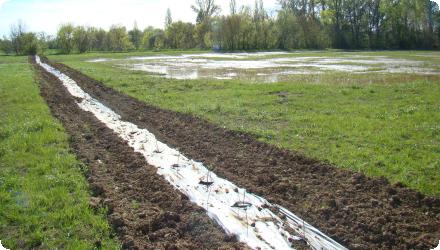
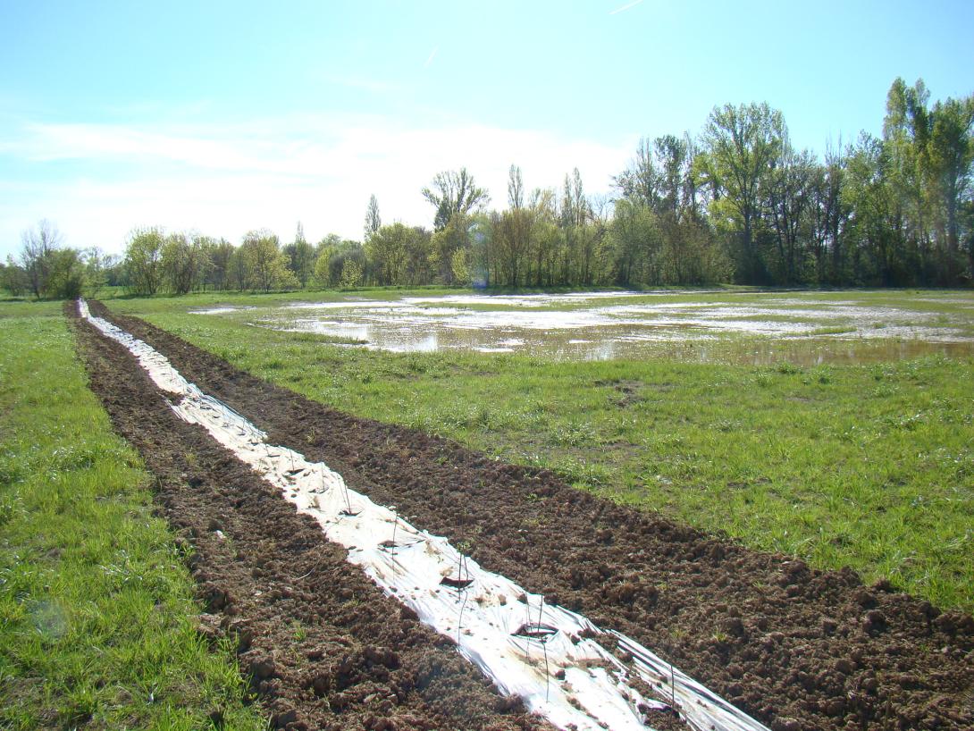
A single 13-ha riparian field was converted to permanent wet meadow with three shallow flood-storage basins and managed by one farm lease—localised hydromorphological intervention.
Project area
13 ha
Multifunctionality (drinking-water protection, flood attenuation, habitat restoration); nature-based sowing via late-cut “hay-flower” transfer; 3 basins up to ~0.8 m deep; transverse hedgerows; no inputs via lease clauses.
Design capacity description
Designed to hold overbank flows; 2013 example: meadow flooded ~2 weeks; basins held water ~1 month. No formal design-storm or storage volume published.
The wet grasslands in the surrounding provide a reservoir for recolonization of wetland fauna and flora when new wetland is created. The conversion to hay meadow allowed the restoration of semi-open wet habitats, in direct proximity to functional habitats of this type, with a direct interest in the associated biodiversity. In addition, the change in land use made it possible to reduce polluting pressures (no use of inputs), thus helping to protect the catchment downstream from diffuse pollution. Finally, the excavation of detention basins made it possible to increase the volume of water stored in the floodplain.
Total cost
€139,000
Costs total information
land €86,000; works/studies/monitoring €53,000
Financing authorities
Type of funding
Sub-national funds
Comments
€69,500
Type of funding
EU-funds: Cohesion and regional development funds
Comments
€41,700
Type of funding
Other
Comments
€27,800
Compensations
0
Policy context
The field was initially cultivated with a rotation of cereals in conventional agriculture, involving in particular the use of pesticides.
The area is flooded regularly, and is totally submerged every 5 years on average.
The area is flooded regularly, and is totally submerged every 5 years on average.
Land ownership
Communauté de Communes de la Gascogne Toulousaine (CCGT), which purchased the 13-ha parcel in 2012 and leases it under an environmental farm lease.
Community involvment
No
Target Remarks
Protect the downstream drinking water abstraction well.
Increase the storage capacity of a flood expansion area.
Promote the typical biodiversity of wet grasslands.
Preserve the quality of the living environment and landscape.
Increase the storage capacity of a flood expansion area.
Promote the typical biodiversity of wet grasslands.
Preserve the quality of the living environment and landscape.
Contractual arrangements
0
Part of wider plan
0
Flood monitoring
the ADASEA du Gers monitors flood episodes by establishing a register of floods and recording area submersed, noting the duration of the flood, submersion extension and nature of the submerged areas with the associated water levels.
Floral monitoring.
Floral monitoring is carried out each year by the national botanical conservatory of Midi-Pyrénées to watch the meadow's evolution.
Flood monitoring
Floral monitoring
Floral monitoring
Hydrological effects
Longer water residence in excavated basins vs meadow; added floodplain storage and runoff slowing; local roughness via hedgerows; morphological change limited to shallow basins.
Information on retained water
Less than expected. The river rarely overflows in the basins as it is flanked by leaves, and the basins dry out too quickly through a ditch.
1
In the absence of flooding in the 2 years after establishment of the meadow, it is mostly mesophilic grassland which developed. Even in detention ponds that were somewhat flooded in winter, there was no vegetation associated with wetlands.
Monitoring shows the evolution of plant communities towards natural grassland species. Ryegrass dominated regrowth in 2014, before declining sharply the following year to make way for natural grassland species. As at Spring 2018, the floristic composition is thus close to a natural meadow.
The flora that has developed is mesophilic, even in the detention ponds. This may be due to relatively dry years after planting, particularly 2016 and 2017.
As of 2024, the vegetation dynamics are gradually evolving towards a wetland habitat.
Key lessons
Looking back, ADASEA regrets that piezometers have not been installed to quantify the hydrological effects of the measurement.
As of 2024, The natural water retention measures are still functional, but they are less effective than expected due to the site's configuration and the layout of the retention basins. The basins mainly fill up when water flows in from the upstream watershed, rather than from river flooding, as the river is flanked by levees that limit overflow. They also dry out too quickly, as the water drains away through a ditch that was unfortunately left in place during the works, at the request of the project owner. New adjustments are currently being considered. On a more positive note, the vegetation dynamics within the basins and the plot, which are being monitored regularly, are promising and are gradually evolving toward a wetland habitat.
As of 2024, The natural water retention measures are still functional, but they are less effective than expected due to the site's configuration and the layout of the retention basins. The basins mainly fill up when water flows in from the upstream watershed, rather than from river flooding, as the river is flanked by levees that limit overflow. They also dry out too quickly, as the water drains away through a ditch that was unfortunately left in place during the works, at the request of the project owner. New adjustments are currently being considered. On a more positive note, the vegetation dynamics within the basins and the plot, which are being monitored regularly, are promising and are gradually evolving toward a wetland habitat.
Success factor(s)
| Success factor type | Success factor role | Comments | Order |
|---|---|---|---|
|
Existing regulations
|
main factor
|
Biotope protection order (APPB) for Bellevalia romana |
Driver
| Driver type | Driver role | Comments | Order |
|---|---|---|---|
|
Availability of subsidies
|
secondary driver
|
The water agency and FEDER subsidies allowed mobilise all actors necessary for the project.
|
|
|
Past flooding events
|
main driver
|
A wetland already recognised in the surrounding, an abstraction well sensitive to diffuse pollution, and the risk associated with the downstream urban area sensitive to flooding (floodable)
|
Transferability
Highly transferable to lowland floodplains where land control is possible. Mind timing of hay-transfer (delays reduce seed bank) and early floods can wash seed; install piezometers to quantify effects; embed in long-term governance (lease + catchment programme).
English