Last update
2025
Summary
Groundwork London, with Hammersmith & Fulham Council, delivered the LIFE+ “Climate-Proofing Social Housing Landscapes” programme (2013–Sep 2016) across three estates (Queen Caroline, Cheeseman’s Terrace, and Cyril Thatcher/Eric MacDonald/Richard Knight) using affordable, light-engineering retrofits of blue-green infrastructure. The project coupled design with deep resident engagement and training for council staff and local apprentices.
Since completion, City Hall has published per-estate schemes and costs (Queen Caroline ~£254k; Cheeseman’s ~£117k; Cyril/Eric/Richard ~£79k) and a detailed measure matrix (e.g., Schotterrasen at Queen Caroline; trench tree pit at Richard Knight). Monitoring by the University of East London shows strong performance: 100% diversion of rainfall from 3,160 m² of impermeable areas into ground-level SuDS, up to 98% reduction in peak flows from pram-shed green roofs, notable roof-surface cooling during heat events, and ≈1.2 million litres of rainwater retained/diverted annually. Post-project, H&F reports continued roll-out of green roofs and SuDS across estates and highways, with mapping to target new sites. Recognition includes the Landscape Institute’s 2016 College of Fellows’ Award (plus a commendation) and susdrain’s 2018 SuDS Awards (Highly Commended).
Since completion, City Hall has published per-estate schemes and costs (Queen Caroline ~£254k; Cheeseman’s ~£117k; Cyril/Eric/Richard ~£79k) and a detailed measure matrix (e.g., Schotterrasen at Queen Caroline; trench tree pit at Richard Knight). Monitoring by the University of East London shows strong performance: 100% diversion of rainfall from 3,160 m² of impermeable areas into ground-level SuDS, up to 98% reduction in peak flows from pram-shed green roofs, notable roof-surface cooling during heat events, and ≈1.2 million litres of rainwater retained/diverted annually. Post-project, H&F reports continued roll-out of green roofs and SuDS across estates and highways, with mapping to target new sites. Recognition includes the Landscape Institute’s 2016 College of Fellows’ Award (plus a commendation) and susdrain’s 2018 SuDS Awards (Highly Commended).
Position
Latitude
51.4911875
Longitude
-0.2259202
Project
NWRM
National Id
United Kingdom_06
Installation date
2013-2017
Implementation Status
Contact
Groundwork London
RBD code
UK06
Transboundary
0
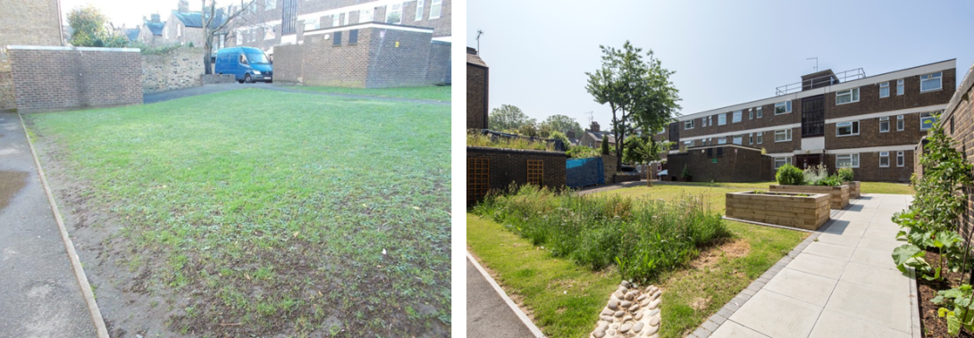
Photo gallery
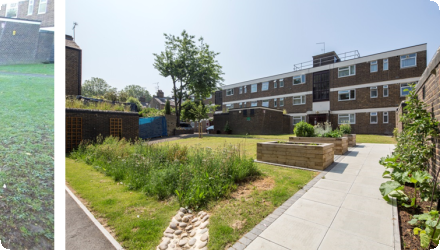
Location of the project
The project sought to deliver a holistic package of climate change adaptation solutions in three social housing estates within the London Borough of Hammersmith and Fulham. The Borough is one of the 32 London Boroughs, situated to the western side of Central London. The River Thames forms the borough boundary to the South and South-West. It is the third smallest of the London Boroughs in terms of land area (1,640 hectares) and currently has a population of c.182,500. Population growth is expected to slow over the next decade, however, it is already one of the most densely populated local authorities in England, with around 114 persons per hectare (pph) compared to the London average of 52pph (LBHF, 2010).
The three estates, owned by the Local Authority, were chosen as demonstration sites because they reflect different social housing contexts (such as property types and estate sizes) that can be found across EU member states, demonstrate vulnerability to increasingly extreme weather conditions, and have high indices of multiple deprivation. In this way, the project was able to demonstrate how green infrastructure adaptation measures can be implemented in a wide range of urban housing settings.
The three estates, owned by the Local Authority, were chosen as demonstration sites because they reflect different social housing contexts (such as property types and estate sizes) that can be found across EU member states, demonstrate vulnerability to increasingly extreme weather conditions, and have high indices of multiple deprivation. In this way, the project was able to demonstrate how green infrastructure adaptation measures can be implemented in a wide range of urban housing settings.
NUTS Code
UKI1 - Inner London
Project's objectives
-Develop a transferable methodology for designing affordable, light-engineering climate change adaptation measures for social housing landscapes using green and blue infrastructure.
-Design and implement comprehensive packages of retrofitting measures in three different types of social housing landscapes.
-Implement the main measures through employment programmes for long-term unemployed beneficiaries creating local jobs.
-Develop a set of training modules for housing and grounds maintenance professionals on the whole cycle of adaptation and green infrastructure relevant procurement systems, design, retrofit and maintenance.
-Develop a transferable methodology for resident stakeholder engagement, resulting in site-specific community adaptation action plans and practical involvement in retrofitting and maintenance activities.
-Design an evaluation methodology capturing technical performance and social return on investment.
-Develop interactive e-learning materials including a film to inform local, national and EU policy, strategy and best practice.
Involved Partners
| Authority type | Authority name | Role | Comments |
|---|---|---|---|
Climate zone
cool temperate moist
Temperature
11.3 °C
Annual rainfall range
600 - 900 mm
Elevation range
10 m
Vegetation class
Urban estates dominated by amenity grassland with scattered trees and ornamental shrub beds, now complemented by wildflower-planted rain gardens, swales, and biodiverse extensive green roofs installed by the project; LBHF manages >27,000 trees borough-wide, including on housing estates.
Water bodies: Ecological Status
Moderate
Water bodies: Chemical Status
Good
Water quality status
Upper Tidal Thames water body is at moderate ecological status; key pressures include CSO discharges from the combined sewer system, urban runoff, and hydromorphological modifications; low-DO events still occur.
Project scale
Micro
Project scale specification
It consists of site-specific retrofits across three housing estates (≈5 ha in total) within one London borough
Project area
0.45
Area specifications
Area of land improved. The project covered three housing estates, impacting several hundred residents and encompassing various green infrastructure interventions.
Size
3360
Size unit
m2
Lifespan
20+ years, depending on the measure
The project was based on principles of climate adaptation, sustainability, and community engagement, aiming to enhance resilience through Nature-Based Solutions.
The design capacities included SuDS capable of managing 1 in 100-year storm events and green roofs absorbing up to 80% of rainfall.
Constraints included limited space in urban settings and existing infrastructure, requiring careful integration of NBS without disrupting current services.
The presence of underutilized open spaces and the need for infrastructure upgrades provided opportunities for implementing NBS.
Total cost
€1,615,636
Costs capital
526,000 EUR
Costs capital information
Cost of the capital works across all three estates.
Financing authorities
Type of funding
EU-funds: LIFE+
Comments
€807,818
Type of funding
Local funds
Type of funding
Local funds
Policy context
The project's core focus has been to demonstrate an integrated approach to climate adaptation in urban areas by undertaking a package of affordable, light-engineering climate change adaptation measures based around the retrofitting of blue and green infrastructure. It focuses on the key challenges of increasing likelihood of climate change impacts on urban areas, and the vulnerability of social housing estates and their residents to these impacts.
Land ownership
London Borough of Hammersmith & Fulham (LBHF) owns the social housing estates where the measures were installed.
Community involvment
Yes
Design consultation activity
| Activity stage | Name | Key issues | Comments |
|---|
Policy target
| Target purpose |
|---|
|
Runoff control
|
Target Remarks
The project aimed to manage stormwater effectively while enhancing biodiversity and providing social amenities.
Policy pressure
| Pressure directive | Relevant pressure |
|---|
Policy impact
| Impact directive | Relevant impact |
|---|
Requirement directive
| Requirement directive | Specification |
|---|---|
|
Floods Directive-mitigating Flood Risk
|
Requirement directive remarks
Adaptation measures of this nature are covered by European policy under the Water Framework Directive and the EU Floods Directive. These measures also demonstrate practical responses in line with the EU Strategy on Adaptation to Climate Change, which encourages all Member States to adopt comprehensive adaptation strategies and recognises that it makes sense to begin with measures that are low-cost, flexible and good for both the economy and the climate.
Policy challenges requirements
The project addressed challenges related to integrating NBS into existing urban infrastructure and aligning with local planning policies.
Contractual arrangements
0
| Arrangement type | Responsibility | Role | Name | Comments |
|---|
Part of wider plan
1
Wider plan type
| Wider plan type | Wider plan focus | Name | Comments |
|---|---|---|---|
|
National
|
Climate adaptation
|
At the national level, the project has contributed to the development of the UK’s approach towards Sustainable Drainage Systems, inputting to a Defra/CLG consultation in 2014. The project has also contributed to SuDS guidance produced by national bodies including CIRIA.
|
|
|
Regional
|
Climate adaptation
|
At the regional level, the project is highly relevant for the London Sustainable Drainage Action Plan, which aims to ensure that London can manage its rainwater sustainably to reduce flood risk and improve water security, and is referred to in the Plan. The project has also contributed to London wide guidance documents, including Transport for London's SuDS Design Guide.
|
|
|
Local
|
Climate adaptation
|
The project has also helped to strengthen local planning policies associated with SuDS and climate change proofing of future developments within Hammersmith & Fulham Council’s new Local Plan, and is also feeding into the new Ecology / Biodiversity Policy that the local authority is proposing.
|
Environmental - technical monitoring; socio-economic - SROI assessment
Technical monitoring:
• Performance of measures during rain events (e.g. infiltration rates) and the development of vegetation captured using fixed-point time lapse cameras at key locations near to the interventions, which took a photo every 15 minutes during the monitoring period (day and night)
• Environmental conditions, including the timings and size of rain events, temperature, wind direction and speed, and humidity, monitored using weather stations; this enabled a comparative analyses to be made with the fixed-point photo monitoring and other monitoring data
• Aspects such as rain water inputs and infiltration times monitored using flowmeters at inlets (e.g. downpipes from roofs) and pressure sensors in basins, in order to understand the impact of selected rainfall events on surface water run-off, and in turn calculate the amounts of water diverted from reaching the sewer network
• Thermal monitoring using a thermal imaging camera to understand the impact on the urban heat island effect, with a focus on key aspects such as green roofs on particularly hot/cold days and comparisons made with untreated surrounding areas
• Biodiversity monitoring on the green roofs, using vegetation surveys to understand the floral species diversity (inventories to record every floral species and quadrats to monitor experimental plots on Richard Knight House); % vegetation cover was also monitored through this process
• Photographic monitoring during site visits to create an archive of the development of biodiversity and to monitor elements as they develop and mature; residents were also encouraged to participate in this through a photography competition
• Simulated storm events to assess how selected interventions would perform in a 1 in 100 year storm event (as they were designed for), by pumping water into the intervention and monitoring data readings from the relevant monitoring equipment such as pressure sensors, as well as undertaking photographic documentation and visual assessment.
SROI:
This measured the benefit of the climate adaptation interventions to local communities beyond their immediate role of improving resilience to climate change - such as community cohesion, understanding of climate change, and awareness of its impacts.
Maintenance
These have been specified in a maintenance schedule provided to the local authority and their maintenance contractors. Maintenance costs are similar to usual housing estate grounds maintenance costs.
Edge of Field/Plot
Technical monitoring:
• Performance of measures during rain events (e.g. infiltration rates) and the development of vegetation captured using fixed-point time lapse cameras at key locations near to the interventions, which took a photo every 15 minutes during the monitoring period (day and night)
• Environmental conditions, including the timings and size of rain events, temperature, wind direction and speed, and humidity, monitored using weather stations; this enabled a comparative analyses to be made with the fixed-point photo monitoring and other monitoring data
• Aspects such as rain water inputs and infiltration times monitored using flowmeters at inlets (e.g. downpipes from roofs) and pressure sensors in basins, in order to understand the impact of selected rainfall events on surface water run-off, and in turn calculate the amounts of water diverted from reaching the sewer network
• Thermal monitoring using a thermal imaging camera to understand the impact on the urban heat island effect, with a focus on key aspects such as green roofs on particularly hot/cold days and comparisons made with untreated surrounding areas
• Biodiversity monitoring on the green roofs, using vegetation surveys to understand the floral species diversity (inventories to record every floral species and quadrats to monitor experimental plots on Richard Knight House); % vegetation cover was also monitored through this process
• Photographic monitoring during site visits to create an archive of the development of biodiversity and to monitor elements as they develop and mature; residents were also encouraged to participate in this through a photography competition
• Simulated storm events to assess how selected interventions would perform in a 1 in 100 year storm event (as they were designed for), by pumping water into the intervention and monitoring data readings from the relevant monitoring equipment such as pressure sensors, as well as undertaking photographic documentation and visual assessment.
Social Return On Investment (SROI): this is a framework for measuring and accounting for a much broader concept of value, incorporating social, economic and environmental costs and benefits. The SROI exercise measured the benefits of the climate adaptation interventions to local communities beyond their immediate role of improving resilience to climate change - such as community cohesion, understanding of climate change, and awareness of its impacts.
The project has delivered a range of social and economic benefits beyond its core environmental benefits. This has predominantly been achieved through the engagement of local residents as part of a comprehensive community engagement programme delivered throughout the project. Residents have been involved in shaping the open space improvements on their estate, helping to grow their awareness of the implications of climate change and the actions they can take. The project has also helped many residents to use the spaces more, including through food growing and gardening clubs which can help to improve their health and well-being and their sense of belonging. Beyond this, the project has, through its Green Teams, given training and employment to young unemployed Borough residents, involving them in the soft landscaping and maintenance of measures.
• 472 residents engaged
• 90% of residents reported an increased understanding of climate change
• 81% of residents said they agree or strongly agree that the quality of the green spaces has improved significantly
• 58% of residents reported their use of the green spaces had increased
• 48% of residents reported an increased sense of belonging
• 67% of residents reported increased pride in the area they live in
• 22 Green Team trainees involved (a training and employment programme for those who are young, unemployed and lacking experience and qualifications)
• 11 job outcomes for Green Team trainees
Green roofs and walls contributed to building insulation, potentially reducing energy consumption for heating and cooling, though specific metrics are not provided.
Hydrological effects
The measures improved local hydrology by reducing surface runoff and enhancing groundwater recharge through permeable surfaces.
Retained water
1,286.8
Retained water unit
m3/year
Information on retained water
• 110 m³ storage designed; 3,360 m² hard area served across estates.
• 100% diversion of rainfall from 3,160 m² of impermeable areas to ground-level SuDS during monitored events.
• Up to 98% peak-flow reduction from green roofs; rapid basin infiltration observed.
• At Queen Caroline alone, runoff from ~1,750 m² was diverted from direct sewer connection
• 100% diversion of rainfall from 3,160 m² of impermeable areas to ground-level SuDS during monitored events.
• Up to 98% peak-flow reduction from green roofs; rapid basin infiltration observed.
• At Queen Caroline alone, runoff from ~1,750 m² was diverted from direct sewer connection
Information on runoff reduction
Divert approximately 1,220,900 litres of rainwater from the sewer system.
Reducing flood risks quantity
The climate adaptation interventions have reduced flood risk across the three demonstration sites
Information on Reducing flood risks, quantity
• 4,537m2 of land improved
• 3,158m2 of impermeable surface diverted from draining directly to the sewer
• 100% of rainfall has been diverted away from the storm drain system by the ground level SuDS
• 89% (on average) of the rainfall landing on the green roofs has been absorbed
• 1,286,815 litres annual rainfall retention and diversion away from the storm drain system by the interventions
Water quality overall improvements
Positive impact-WQ improvement
Information on Water quality overall improvements
Ground level SuDS systems created a 100% improvement in surface water pollution, as no surface water was recorded leaving any of the designed elements and feeding into the combined sewer system.
1
Green roofs on all three estates are supporting biodiversity, with a net increase of 64 species identified compared to normal flat roofs. Some of the interventions have also been planted with wildflower turf to further support biodiversity objectives.
Information on Other biophysical impacts
• 2,630m2 of new and enhanced green infrastructure
• Vegetation cover: 782m2 increase in soft landscape
• Biodiversity: residential green roof at Richard Knight House: A net increase of 64 species compared to standard flat roof.
• Temperature: max 35.73% reduction in temperature on a green roof compared to surrounding grey infrastructure
• Green roofs: 432m2 area
• Food growing: 24m2 capacity
Other Biophysical impacts
Vegetation cover, biodiversity, temperature
Key lessons
• Retrofitting open spaces in social housing environments is both necessary and cost-effective: affordable and socially acceptable light-engineering climate adaptation measures implemented through the project help to demonstrate the role these spaces can play in increasing urban resilience to climate change
• Such projects work better when not delivered in isolation: climate adaptation is multi-faceted and requires cross-disciplinary working – from consultation to co-design, from community engagement activities to training and employment opportunities
• Communities, in particular residents, are expert users of spaces and have valuable knowledge of their local environment: their involvement from the start of the project has been essential to secure their input and support
• A comprehensive approach to monitoring and evaluation can help make the business case for such schemes: as exemplified by this project, this should not only include technical monitoring of the environmental benefits, but also additional evaluation to capture the wider social and economic benefits of the project.
Success factor(s)
| Success factor type | Success factor role | Comments | Order |
|---|---|---|---|
|
Financing possibilities
|
main factor
|
<p>Retrofitting open spaces in social housing environments is both necessary and cost-effective: affordable and socially acceptable light-engineering climate adaptation measures implemented through the project help to demonstrate the role these spaces can play in increasing urban resilience to climate change </p>
|
|
|
Successful coordination between authorities
|
main factor
|
<p>Such projects work better when not delivered in isolation: climate adaptation is multi-faceted and requires cross-disciplinary working – from consultation to co-design, from community engagement activities to training and employment opportunities. This project benefited from Groundwork London working closely with the local authority, with a range of teams involved from each organisation and other external stakeholders involved in different aspects of the project - from design, to implementation and evaluation. </p>
|
|
|
Public participation
|
main factor
|
<p>Communities, in particular residents, are expert users of spaces and have valuable knowledge of their local environment: their involvement from the start of the project has been essential to secure their input and support.</p>
|
|
|
Conducted assessments (incl. economic)
|
main factor
|
<p>A comprehensive approach to monitoring and evaluation can help make the business case for such schemes: as exemplified by this project, this should not only include technical monitoring of the environmental benefits, but also additional evaluation to capture the wider social and economic benefits of the project</p>
|
Driver
| Driver type | Driver role | Comments | Order |
|---|---|---|---|
|
Past flooding events
|
main driver
|
The three estates had all previously suffered from surface water flooding, water pooling on estate roads and paths, and located close to Category 1 CSO (meaning that it operates frequently and has adverse environmental impacts).
|
|
|
Organisation committed to it
|
secondary driver
|
H&F Council is keen to be recognised as a lead authority in advancing effective approaches to climate adaptation at a neighbourhood and Borough wide scale. The local authority, who owns the three estates used as demonstration sites in this project, is now using the lessons learned from the project to explore the feasibility of rolling out green infrastructure based climate adaptation initiatives in other housing estates across the borough.
|
Flexibility adaptability
A number of the interventions have been designed with greater capacity than was required at the time of installation, so that if the changing climate results in greater rainfall than expected, the measures will be able to withstand this. This has been tested through a storm simulation at one of the swales, in which a 1 in 100 year storm was simulated by pumping 10,000 litres of water into the swale over the course of an hour - at no point during the storm simulation did water pooling in the swale reach the swale’s stormwater overflow.
Transferability
The project aimed to develop a methodology that would be applicable and transferable to other housing estates, not only within the UK but also across Europe. Various resources have been developed in order to share learning from the project and support other housing providers to develop and deliver similar initiatives, including an Implementation Guide, training materials, a Layman’s Guide, project film and 360 virtual tour. These are available on the project’s dedicated website, www.urbanclimateproofing.london.
Cost effectiveness
The SROI gave a social value of the project as £4.39 in benefits for every £1 invested.
Source(s)
English