Last update
2025
Summary
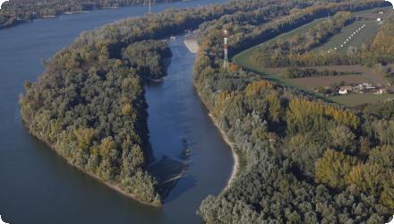
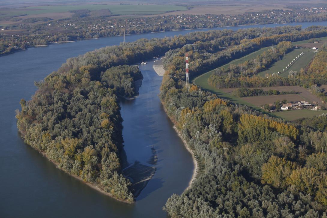
Liberty Island (Szabadság-sziget) lies north of Mohács on the Danube’s left bank; it is ~3 km long, 150–200 m wide and 47 ha, strictly protected within Danube–Drava National Park and the Natura 2000 network. Bank-filtered wells along this bank supply South Baranya settlements.
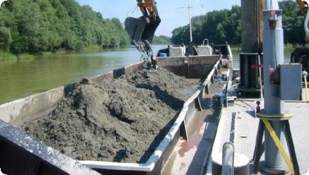
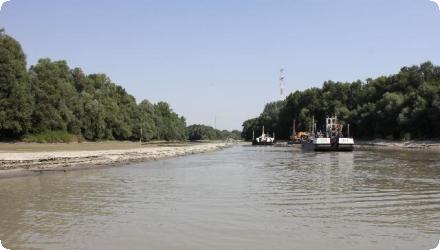
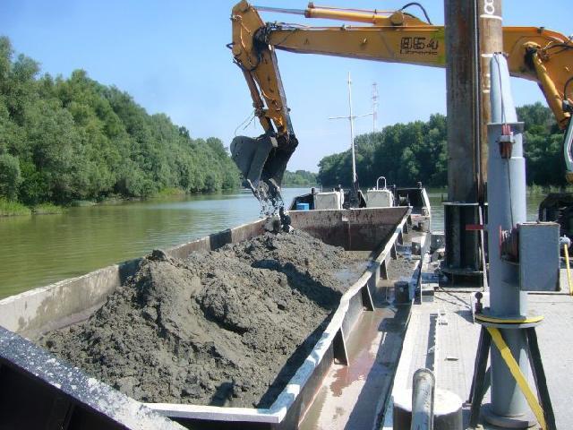
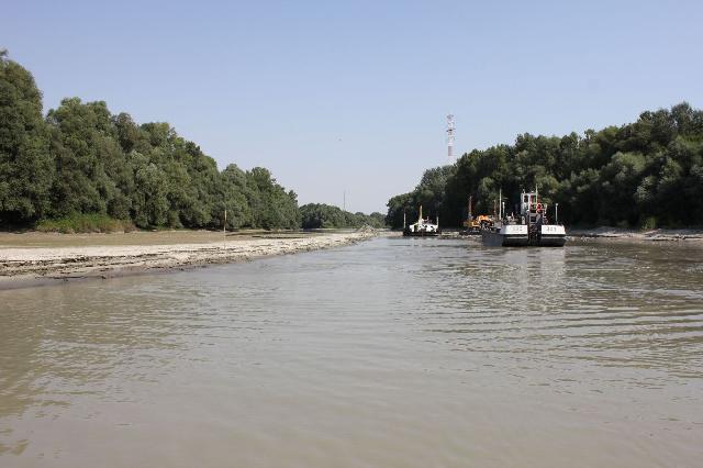
From 2009–2013 a LIFE+ project led by WWF Hungary with DDNP, the Lower-Danube Water Directorate and DRV Zrt. reopened the side-arm by partially removing the 1980s rock-fill dam, relocating the drinking-water pipe beneath the bed, and dredging ≈160,000 m³ of sediment; invasive trees were removed and native softwood floodplain forest restored.
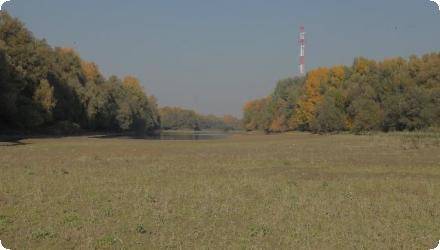
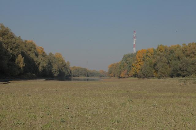
Since completion, the arm flows freely again (about 40–60 m wide and ~2 m deep even at low water), improving natural bank filtration and reducing treatment needs; a boat-accessible nature trail was created.
Post-project monitoring (2018–2020) found 35 fish species, including protected EU/HU taxa, and confirmed spawning use of the reconnected arm. Bathymetric observations indicate overall slowed infilling, though in very low flows upstream sections can still be intermittently disconnected by shoals/wood jams; management is guided by the Béda-Karapancsa Natura 2000 plan.
From 2009–2013 a LIFE+ project led by WWF Hungary with DDNP, the Lower-Danube Water Directorate and DRV Zrt. reopened the side-arm by partially removing the 1980s rock-fill dam, relocating the drinking-water pipe beneath the bed, and dredging ≈160,000 m³ of sediment; invasive trees were removed and native softwood floodplain forest restored.
Since completion, the arm flows freely again (about 40–60 m wide and ~2 m deep even at low water), improving natural bank filtration and reducing treatment needs; a boat-accessible nature trail was created.
Post-project monitoring (2018–2020) found 35 fish species, including protected EU/HU taxa, and confirmed spawning use of the reconnected arm. Bathymetric observations indicate overall slowed infilling, though in very low flows upstream sections can still be intermittently disconnected by shoals/wood jams; management is guided by the Béda-Karapancsa Natura 2000 plan.
Position
Latitude
46.018883
Longitude
18.689315
Project
NWRM
National Id
HU_06
Installation date
2013
Implementation Status
Contact
Laurice EREIFEJ – Head of WWF DCP Freshwater Programme - WWF Hungary
RBD code
Danube
Transboundary
0
Photo gallery
Location of the project
Close to city of Mohacs; part of Duna-Drava National Park, Béda-Karapancsa region
Islands of the Danube and their side-arms are home to extraordinarily rich wildlife: all the species living in the side branches require milder waterflow compared to the main branch, warmer water, riparian vegetation and rambling hideouts
Islands of the Danube and their side-arms are home to extraordinarily rich wildlife: all the species living in the side branches require milder waterflow compared to the main branch, warmer water, riparian vegetation and rambling hideouts
Project's objectives
Reconnect the Danube side-arm by removing the rock-fill barrier and relocating two water pipes beneath the bed, restoring year-round flow.
Dredge the silted channel (planned as ~one-third of the arm’s width; ultimately 160,000 m³ removed) to re-establish a self-sustaining cross-section.
Restore native softwood floodplain forest by clearing invasive/non-native stands and replanting, on the 47 ha island purchased and set aside for conservation.
Safeguard drinking-water quality by improving natural bank filtration after reconnection; create low-impact public access via a nature trail.
Involved Partners
| Authority type | Authority name | Role | Comments |
|---|---|---|---|
Climate zone
cool temperate moist
Temperature
12.3 °C
Precipitation
684
Annual rainfall range
600 - 900 mm
Elevation range
84 m
Vegetation class
Softwood floodplain (willow–poplar) gallery forests (Natura 2000 habitat 91E0*), with associated alluvial habitats; this is explicitly the target of the restoration and the dominant cover on/is around the island.
Water bodies: Ecological Status
Unknown
Water bodies: Chemical Status
Unknown
Water quality status
historic hydromorphological alteration and sedimentation of the side-arm (blocked by a rock-fill dam in 1982), plus invasive tree species; these were addressed by dam removal/side-arm dredging and forest restoration.
Project scale
Micro
Project scale specification
a site-specific side-arm reconnection and habitat restoration on a ~3 km branch at rkm 1448–1452 (Liberty Island, Mohács), i.e., a localised hydromorphological intervention within a larger river system.
Total cost
Total budget: 1 795 529 €
Costs total information
EU co-financing: 1 075 896 €, 75% of eligible costs, approx.
Costs other information
The project was implemented by 4 different organisations as beneficiaries. They provided their own contribution. The risk of exchange rate changes was borne by the coordinated beneficiary. At the end, its effect was positive and it helped to keep within the planned project budget. The Financial Report was compiled by merging the internal financial progress reports, prepared by each beneficiary.
The respective costs of the different actions were as follows:
- 46% dredging
- 22,6% waterpipe relocation
- 9% buying the island
- 6,5% forestry works
- 4,4% environmental impact assessment and monitoring
- 3,2% communication
- 2,8% opening the rock-fill dam (after waterpipe relocation)
- 5,4% project management.
Financing authorities
Type of funding
EU-funds: LIFE+
Comments
€1,075,896
Type of funding
Private funds
Comments
€300,000
Type of funding
Local funds
Type of funding
Other
Compensations
0
Policy context
The side-arm behind Liberty Island was blocked by a rock-fill dam (1982) to favour navigation and carry drinking-water pipes. This cut off flow, caused rapid siltation and stagnant water, degraded alluvial softwood habitats (Natura 2000: 91E0*) and undermined the bank-filtration resource used for drinking water. In Water Framework Directive terms, the main pressure addressed is hydromorphological alteration : disconnection of a side arm, with impacts on quantity & dynamics of flow and substrate conditions.
Land ownership
The island was bought within the LIFE project and transferred to the Hungarian State, with day-to-day management by the Danube-Drava National Park Directorate (DDNP).
Community involvment
No
Design consultation activity
| Activity stage | Name | Key issues | Comments |
|---|
Policy target
| Target purpose |
|---|
Policy pressure
| Pressure directive | Relevant pressure |
|---|
Policy impact
| Impact directive | Relevant impact |
|---|
Requirement directive
| Requirement directive | Specification |
|---|
Contractual arrangements
0
| Arrangement type | Responsibility | Role | Name | Comments |
|---|
Part of wider plan
0
Wider plan type
| Wider plan type | Wider plan focus | Name | Comments |
|---|
Required monitoring covers morphodynamics (bathymetry/sedimentation), fish community status, and raw well-water quality, now being followed up under the MERLIN 2021–2025 programme and earlier surveys.
Morphology/hydraulics: channel cross-sections, depths, erosion–deposition patterns, effectiveness of the sediment trap, and flow continuity at low water (surveys 2015–2019).
Biota (fish): species richness/abundance, presence of protected/Habitat-Directive species, and use of the reconnected arm for spawning (35 species recorded, 2018–2020; electrofishing + electric benthic trawl).
Water (drinking supply interface): raw water quality at bank-filtration wells adjacent to the side arm (WWF stated intent to track post-restoration improvements).
Maintenance
Routine upkeep consists mainly of targeted sediment removal focused at the mouth’s sediment trap and short-term after-care of replanted softwood forest, coordinated under DDNP/WWF with ADUVIZIG support.
Improved raw water quality / lower treatment needs. After reconnection, bank-filtered wells along the Danube “provide cleaner water, thus requiring less purification” for the regional waterworks serving Pécs/Mohács. This was an explicit expected benefit and part of the project’s monitoring focus.
Securing supply for local communities. The project aimed to “secure pure, safe drinking water for the south part of Baranya county.”
Recreation, eco-tourism & local use : New low-impact access. A nature study/water trail was created along the side-arm; DDNP rangers include the site in guided tours. Local boating/fishing amenity. The reopened arm is promoted by local operators (1-hour tours into the arm “opened in 2013”) and was framed to provide a safe area for bathing, fishing and boating.
Awareness and learning. Deliverables included information boards in Mohács and on site, 10,000 leaflets, five project films, an international closing conference, and an After-LIFE Conservation Plan to continue activities.
Information on retained water
The cross-dam was opened and ~160,000 m³ of sand/silt were dredged; ~6,000 m³ of rock from the dam were removed; two large drinking-water pipes were lowered beneath the bed. The dredged material was released to the main Danube branch to counter sediment deficit.
Outcome on the side-arm: it now flows again and holds “almost two meters” depth throughout the year (design aimed at self-sustaining geometry and slower re-silting).
Limitation under extremes: during 2018’s very low water, the upper part of the side-arm fell dry; only the lower reach could be sampled. (This documents intermittent conditions at extreme low flows.)
1
Fish community monitoring (12 sampling days, Aug 2018–Nov 2020) captured 10,546 individuals of 35 species; 8 species protected nationally and 10 listed in the EU Habitats Directive. Notably, Ukrainian brook lamprey (Eudontomyzon mariae, strictly protected) and Bulgarian golden loach (Sabanejewia bulgarica) were recorded. Flow-loving species re-appeared in the reconnected arm and used it for spawning as species absent when the dam was in place.
Key lessons
Design matters. Making the side-arm geometry as self-sustaining as possible slowed re-silting; the work sequence (relocate drinking-water pipes → open rock-fill dam → dredge ~160,000 m³; return dredgings to the main branch) was critical to success and navigation safety.
Partnership is the lever. A public–private–NGO coalition (WWF, DDNP, ADUVIZIG, DRV, Mohács, Coca-Cola, LIFE) enabled permits, funding and delivery—explicitly highlighted as the project’s transferable lesson.
Plan for real-world frictions. The team used adaptive management and built buffer time; fieldwork was slowed by weather, low water and machinery breakdowns; cash-flow and co-financing were non-trivial under EU reimbursement rules; reporting was heavy; four separate permits were required.
After-care and monitoring are not optional. Young softwood forest needed several years of tending; sedimentation and raw-water quality require continued tracking. Fish monitoring (2018–2020) showed rapid biodiversity gains but also that the upper reach can fall dry in extreme low flows, so vulnerability remains.
Success factor(s)
| Success factor type | Success factor role | Comments | Order |
|---|---|---|---|
|
Successful coordination between authorities
|
main factor
|
Multi-actor coalition with aligned interests (state, park directorate, water directorate, utility, city, NGO, corporate co-financier). |
|
|
Other
|
secondary factor
|
Scientifically designed, self-maintaining cross-section and correct work sequencing (pipes → dam → dredging → reuse of dredgings). |
|
|
Attitude of relevant stakeholders
|
main factor
|
Land purchase and transfer to the State, end of commercial forestry, native softwood floodplain replanting with after-care. |
|
|
Communication activities
|
secondary factor
|
External LIFE monitoring and proactive communication (films, events) to sustain buy-in. |
Driver
| Driver type | Driver role | Comments | Order |
|---|---|---|---|
|
Organisation committed to it
|
main driver
|
Local political impetus & strong stakeholder management (mayor-initiated; emphasis on coordination).
|
Transferability
This was a special project with the partnership of NGO, state owned directorates, municipality and drinking water supply company. However there is huge potential for the reconnection of side-branches to the Danube on the whole Hungarian Danube. The experiences of Liberty Island project can be replicable in any upcoming restoration works.
English