Last update
2025
Summary
Bas-Rhin is highly exposed to muddy runoff during spring–early-summer storms, impacting villages downstream of cropped slopes. Since 2008, the Chamber of Agriculture and local authorities diagnose erosion risk at commune scale and co-design preventive measures (concerted crop rotations, a gradual shift to no-till) and curative “soft hydraulics” (dense hedges and live/dead fascines, grass or miscanthus strips), implemented by municipalities or intermunicipal bodies.
Since 2018, the Eurométropole de Strasbourg holds competence for runoff/erosion control. With BRGM, it uses the WATERSED model to rank 96 catchments across 14 at-risk communes and update priorities each year; modelled sediment reductions are typically 50–95% (and >60% for a 10-year storm once devices are in place). Implementation is formalised through 10-year contracts with farmers, with standard annual compensation per area. By 2019–2023, about 129 devices (~9.9 km) were (re)installed under 53 conventions. Recent municipal programmes combine agronomy with hedges/fascines/miscanthus and resized swales (e.g., Eckwersheim), while other communes report site-specific packages (e.g., Lampertheim: 600 m of live fascines and 200 m of grass strips). Regional guidance (DREAL Grand Est) and AERM support frame the approach at departmental/basin scales.
Since 2018, the Eurométropole de Strasbourg holds competence for runoff/erosion control. With BRGM, it uses the WATERSED model to rank 96 catchments across 14 at-risk communes and update priorities each year; modelled sediment reductions are typically 50–95% (and >60% for a 10-year storm once devices are in place). Implementation is formalised through 10-year contracts with farmers, with standard annual compensation per area. By 2019–2023, about 129 devices (~9.9 km) were (re)installed under 53 conventions. Recent municipal programmes combine agronomy with hedges/fascines/miscanthus and resized swales (e.g., Eckwersheim), while other communes report site-specific packages (e.g., Lampertheim: 600 m of live fascines and 200 m of grass strips). Regional guidance (DREAL Grand Est) and AERM support frame the approach at departmental/basin scales.
Position
Latitude
48.682818
Longitude
7.686808
Project
NWRM
National Id
France_12
Installation date
2008
Implementation Status
RBD code
FRC
Transboundary
0
Photo gallery
Location of the project
The Bas-Rhin department is located in the North-East of France. The Rhine plain land-use is mostly dedicated to Spring crops with no landcover during winter. Crops are located on the top of the hills and on the slope, while villages lie in the lower land.
NUTS Code
FR42 - Alsace
Project's objectives
Reduce muddy-flood risk and sediment delivery; increase winter cover/no-till: e.g., Willgottheim planned non-till area growth from 4%→12% in 2019; some communes already 10–>75% no-till; implement linear soft-hydraulics at priority outlets.
Involved Partners
| Authority type | Authority name | Role | Comments |
|---|---|---|---|
Temperature
11.4 °C
Precipitation
635.7 mm
Elevation range
154 m
Vegetation class
Dominated by non-irrigated arable land (cereal/maize rotations) on fertile loess; hedgerows relatively scarce; small vineyard fringes on the “Couronne d’Or”.
Water bodies: Ecological Status
Bad
Water bodies: Chemical Status
Failing to achieve good
Water quality status
Diffuse agri pressures: suspended solids from erosion/muddy floods; nutrients (nitrates) and pesticides in surface & groundwater; local hydromorphological alterations near urban fringe.
Project scale
Large
Project scale specification
The policy was conducted over a long period in the region.
Project area
33
Area specifications
33 ha with soft hydraulics implemented (2020).
Over 36 000 m of hedges, fascines, miscanthus strips or grass buffer strips.
Over 36 000 m of hedges, fascines, miscanthus strips or grass buffer strips.
Combination of prevention and curative measures :
- Erosion prevention through concerted crop rotation and converting to no-till farming techniques.
- Soft hydraulics vegetal curative measures (hedges, bufferstrips, fascines).
- Erosion prevention through concerted crop rotation and converting to no-till farming techniques.
- Soft hydraulics vegetal curative measures (hedges, bufferstrips, fascines).
Prevention methods are based on the voluntary participation of farmers.
Total cost
tens of thousands of euros per municipality
Costs total information
Eckwersheim (2018): €32,762; AERM 80% (€26,210), commune 20% (€6,552).
Willgottheim (2008): €47,500; AERM 80% (€38,000), commune 20% (€9,500).
Willgottheim (2019–20): €104,886; AERM €97,578, SDEA €7,308.
Lampertheim (REx 2022 cases): €14,943; €12,789; €56,600, with AERM co-funding (40–80%) and Region 20% in one case; EMS project owner in later phase.
Willgottheim (2008): €47,500; AERM 80% (€38,000), commune 20% (€9,500).
Willgottheim (2019–20): €104,886; AERM €97,578, SDEA €7,308.
Lampertheim (REx 2022 cases): €14,943; €12,789; €56,600, with AERM co-funding (40–80%) and Region 20% in one case; EMS project owner in later phase.
Financing authorities
Type of funding
Local funds
Comments
Eckwersheim , Willgottheim , Lampertheim
Type of funding
Sub-national funds
Compensations
1
Compensations basis information
SDEA compensates farmers for the loss of land used for soft hydraulics measures.
Policy context
The Bas Rhin department is regularly subject to muddy water flows. These occur during Spring and summer storms on silty hills with Spring crops (beets, corn, etc.).
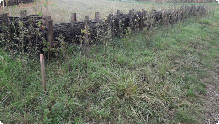
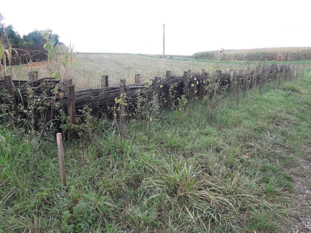
Silt mobilized by rainfall on bare plots is carried downstream, where there are sensitive issues such as villages in the valleys (Figure 1). Mudflows impact both the receiving area (villages and local residents) and the emitting area (loss of soil for farmers).
Several factors have led to an increase in the risk of this phenomenon occurring since the 1950s:
Climate changes favouring heavier rains earlier in the season.
The decrease in grassland (-44% cattle between 1979 and 2000) and the increase in agricultural areas with little coverage during Spring and early summer.
Theimplementation of land consolidation actions leading to an extension of the field size and the removal of landscape elements (hedges, rural roads, embankments, etc.).
Urbanisation is also accompanied by the artificialisation of soils (+1047 ha/year between 1984 and 2000) and the progressive removal of buffer zones such as orchards and meadows.
As a result, the frequency of muddy water flows has increased, and they occur earlier and earlier in the season.
Land ownership
Mostly private farmland (individual farmers). Devices are installed via farmer–authority agreements on private plots, with some on municipal land/rights-of-way; works led by communes/intercommunalities, SDEA and Eurométropole.
Community involvment
No
Design consultation activity
| Activity stage | Name | Key issues | Comments |
|---|
Policy target
| Target purpose |
|---|
|
Erosion Control
|
|
Peak-flow reduction
|
Target Remarks
Prevention of erosion through agricultural practices.
Curative measures against mudslides through soft hydraulics.
Curative measures against mudslides through soft hydraulics.
Policy pressure
| Pressure directive | Relevant pressure |
|---|
Policy impact
| Impact directive | Relevant impact |
|---|
Requirement directive
| Requirement directive | Specification |
|---|
Contractual arrangements
1
| Arrangement type | Responsibility | Role | Name | Comments |
|---|---|---|---|---|
|
Contractual agreement
|
SDEA implements the measures and compensates the surface loss.
The farmer provides the field and complies with the agreed land management measures. |
Collective agreement between SDEA and individual farmers
|
200 collective agreements signed as of 2020.
|
Part of wider plan
0
Wider plan type
| Wider plan type | Wider plan focus | Name | Comments |
|---|
Annual inspection by the sites managers.
Maintenance
Hedge trimming and replacement of dead fascines.
Information on retained water
Modeling for the EMS area (96 catchments) shows ~50% theoretical reduction in sediment loads with networked soft-hydraulics; BRGM also reports potential ~80% reduction if all planned and existing devices operate optimally. Field observations confirm sediment trapping.
Information on runoff reduction
The effectiveness of soft-hydraulic measures has been demonstrated by modelling of watersheds concerned with muddy casting phenomena. The visual observation of the various carriers of project confirms the retention of sediments by the soft hydraulic developments. The co-benefits of this work are landscape improvement, restoration of habitat for small wildlife, and softening of tensions between farmers and inhabitants of villages that have been impacted by past muddy water flows. The measures are also considered less expensive in the short term than the construction of mud ponds.
Key lessons
The combination of preventive measures (crop rotation, no-tillage cultivation) and curative measures have reduced the risk of mudflow. Although how much is still unknown as there has not been massive erosion and mudslide events since the implementation of these measures.
Dead fascines are not durable enough; live fascines or hedgerows are preferable. Good management of the hedges growth (particulary the first trimming) is necessary for their efficiency against mudslides. The plant species to be selected should be local species that propagate easily through suckering.
Dead fascines are not durable enough; live fascines or hedgerows are preferable. Good management of the hedges growth (particulary the first trimming) is necessary for their efficiency against mudslides. The plant species to be selected should be local species that propagate easily through suckering.
Success factor(s)
| Success factor type | Success factor role | Comments | Order |
|---|---|---|---|
|
Attitude of relevant stakeholders
|
main factor
|
<p>The recurrence of mudslides in the department and the impacts on the inhabitants and the search for solutions to the problems faced by local residents. <br>The work done by the Agriculture chamber as a result of the departmental regrouping facilitated the choice and the location of development measures. <br>The multiplicity of actors involved in this departmental approach is important: communes, metropolis, unions, agriculture chamber, farmers, researchers, etc. The project managers note a positive development of the acceptance of soft hydraulics measures by the agricultural profession over the last ten years. </p><p>In the short term, these works are also cheaper alternative measures compared to the implementation of conventional retention basins (but In the long term, the costs of compensation and maintenance are important). </p>
|
Driver
| Driver type | Driver role | Comments | Order |
|---|---|---|---|
|
Past flooding events
|
main driver
|
Historical regular massive mudslides events in the region conviced the authorities and farmers alike of the necessity of these measures.
|
Transferability
Highly transferable to loess/cereal plateaus: pair cropping changes with distributed soft-hydraulics; design at sub-basin scale. Critical: farmer buy-in, legal timing for hedge works, long-term maintenance & compensation, and iterative siting using flow modeling.
English