Last update
2025
Summary
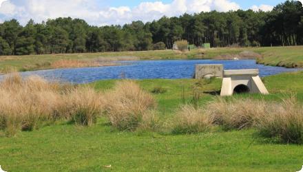
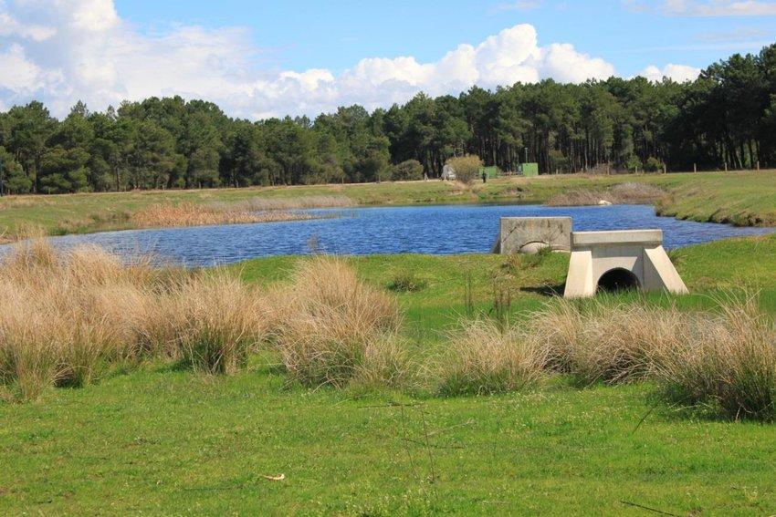
Managed Aquifer Recharge (MAR) in Los Arenales, Spain, aims to address severe groundwater overexploitation through the seasonal diversion of surplus flows from the Cega and Voltoya rivers into infiltration basins and channels. Since the early 2000s, three MAR systems (El Carracillo, Santiuste, Pedrajas–Alcazarén) have helped reverse declining groundwater trends - replacing average losses of −1.4 m/year with rises of +0.3 m/year - while also improving water quality through soil filtration, notably reducing nitrates.
The systems are low-energy and gravity-fed, co-managed by the Duero River Basin Authority (CHD) and local irrigation communities. Monitoring shows benefits for aquifer recovery, flood buffering, wetland restoration (e.g. La Iglesia Lake), and energy savings (~22% reduction in pumping), with positive socio-economic outcomes including improved irrigation security and reduced rural depopulation.
Recent adjustments have been made to optimise recharge periods and flow thresholds from the Cega River, ensuring ecological flows are maintained. During droughts, stored water from wet years allows irrigation to continue, even if aquifer levels temporarily decline. These are recovered in subsequent wetter periods. The recharge system is well accepted by users, and flood events are managed by redirecting excess water back to the Pirón River, minimising basin transfer effects.
Position
Latitude
41.1445
Longitude
-4.572
Project
NWRM
National Id
Spain_03
Installation date
2002
Implementation Status
Contact
Estefanía Ibáñez (IMDEA Water) in close cooperation with Enrique Fernández Escalante (TRAGSA-SEPI) whose valuable contribution is acknowledged and very much appreciated.
RBD code
ES020
Transboundary
0
Photo gallery
Location of the project
The Los Arenales Managed Aquifer Recharge (MAR) project is located in the southern part of Castile and León, in central Spain, within the Duero River Basin. The project spans several municipalities across Segovia and Valladolid provinces, and targets the Los Arenales Groundwater Body (LAGB).
NUTS Code
ES41 - Castilla y León
Project's objectives
Reverse groundwater overexploitation in the Los Arenales aquifer
Secure water supply for irrigated agriculture in the region
Recharge the aquifer using surface water surpluses
Improve water quality through natural soil filtration
Test and validate MAR as a long-term water management tool
Promote participatory water governance
Secure water supply for irrigated agriculture in the region
Recharge the aquifer using surface water surpluses
Improve water quality through natural soil filtration
Test and validate MAR as a long-term water management tool
Promote participatory water governance
Involved Partners
| Authority type | Authority name | Role | Comments |
|---|---|---|---|
Climate zone
cool temperate moist
Temperature
11,2
Precipitation
461
Annual rainfall range
300 - 600 mm
Evapotranspiration
379
Elevation range
828
Slope range
0-1%
Vegetation class
The region is a rural agricultural zone dominated by irrigated crops, especially in the El Carracillo and Santiuste systems.
Water bodies: Ecological Status
Good
Water bodies: Chemical Status
Good
Water quality status
The main pressure is diffuse agricultural pollution, particularly nitrate contamination of groundwater.
Project scale
Meso
Project scale specification
The project covers a regional portion of the Duero River Basin, targeting the Los Arenales Groundwater Body, which spans around 2,400 km² across multiple municipalities in Segovia and Valladolid provinces. It involves three MAR systems (El Carracillo, Santiuste, and Pedrajas–Alcazarén), coordinated under basin-level planning by the Confederación Hidrográfica del Duero (CHD). While not national in scope, it operates at the sub-basin and multi-municipal scale, addressing regional water resource challenges related to agriculture, groundwater overexploitation, and climate adaptation.
Performance timescale
< 1 year
Project area
4800
Area subject to Land use change or Management/Practice change (ha)
7,55819988250732
Size
27960
Size unit
m2
Lifespan
At least 30 to 50 years, assuming regular maintenance and adaptive management.
Peak flow (for a standard return period of 5 years) = 100 m3/s
Peak flow (for a return period of 500 years) = 560 m3/s
Peak flow (for a return period of 500 years) = 560 m3/s
Design capacity description
The system was designed for a maximum water flow of 1000 l/s (or 1 m3/s) and a maximum annual volume of 8 hm3.
In winter, water freezing reduce infiltration to the aquifer. This might be relevant considering that the concesion of water for this propose goes from November to April.
Some years have not been successful due to silting up in soakways and pond.
The water transfer from Voltoya River to the recharge channel needed to be stopped during heavy rain days in order to avoid flooding.
Additionally, the Lisse effect (excess of air trapped in to the aquifer reduces the infiltration capacity) has been a problem during the implementation, having to modify the design and structure of the devices.
Erotion of soakways/channels banksides, jeopardising stability.
The transfer of water to the recharge system was only allowed is the flow in Voltoya river was be above 600 l/s (in order to guarantee the ecological flow.
The channel was designed to take advantage of the former route of the Ermita strem to enhance infiltration.
Essays and monitoring in the site of study showed that in areas were the aquifer was more than 3m deep, infiltration was more effective.
Literature lists favourable conditions for aquifer recharge: scant vegetation, permeable or fractured soil, high water table level, and aboundant rainfal (De Vries and Simmers, 2002).
Total cost
€ 4,608,946
Costs total information
Initial investment until 2006:
Water intake: 409657 €
Transfer conveyance: 2641615 €
Recharge channel 1: 289940 €
Recharge channel 2: 606867 €
Investment in the second period: 660867€ (The amount was devoted to maintenance, studies and projects)
Water intake: 409657 €
Transfer conveyance: 2641615 €
Recharge channel 1: 289940 €
Recharge channel 2: 606867 €
Investment in the second period: 660867€ (The amount was devoted to maintenance, studies and projects)
Costs operation maintenance
3000
Costs operation maintenance information
Each recharge cycle had maintenance works of the channel and basins depending on the results of the previous year. However, there is not a specific budget with details on these specific costs.
Information on Economic costs - income loss
In very wet years, agricultural fields (generally with potato crops) have been occasionally flooded after the groundwater level reached the limit that should not be exceeded in aquifer managment and recharge practices (defined in 1.5m by Fernández Escalante, 2005).
Financing authorities
Type of funding
National funds
Type of funding
Sub-national funds
Type of funding
EU-funds: Rural development funds
Comments
European Agricultural Guarantee Fund
Type of funding
Other
Comments
Trasgsa (public company) financed an RTD programme (2007-2010) to continue the research activity regarding aquifer management activities. SEPI Group (Spanish Society of Industrial Participations) was the main shareholder
Compensations
0
Compensations annual information
There is no specific records of compensation payments to landowners or irrigators affected by the measure. In fact, the implementation of the measure was originated from a social claim to recover a damage aquifer, and irrigators and landowners were involved in the petition.
Policy context
The exploitation of the superficial aquifer, mainly for irrigated agriculture, has led to a 10 m fall of the water table, which has led to related salinization and pollution processes. [WFD pressure: 3.1 Abstraction, Agriculture]
Land ownership
Mostly publicly owned or managed under easement agreements with local irrigation communities (ICs).
Community involvment
No
Design consultation activity
| Activity stage | Name | Key issues | Comments |
|---|
Policy target
| Target purpose |
|---|
|
Groundwater Recharge
|
|
Increase Water Storage
|
Policy pressure
| Pressure directive | Relevant pressure |
|---|
Policy impact
| Impact directive | Relevant impact |
|---|
Requirement directive
| Requirement directive | Specification |
|---|
Contractual arrangements
1
| Arrangement type | Responsibility | Role | Name | Comments |
|---|---|---|---|---|
|
Contractual agreement
|
Use the diverted surface water legally and transparently.
Operate and maintain MAR infrastructure locally. |
The Irrigation Community (IC) of El Carracillo signed agreements with the Confederación Hidrográfica del Duero (CHD).
|
Public–User Agreements with Irrigation Communities
|
These agreements are formalised under Spanish water rights legislation, where ICs receive water concessions for shared use and commit to maintaining infrastructure and adhering to operating rules.
|
|
Contractual agreement
|
Land use rights were formalised via easement agreements or permits, enabling CHD and ICs to build and manage infrastructure.
|
Infiltration basins and canals were sometimes built on public land or land ceded temporarily or permanently by municipalities or landowners.
|
Land Use and Access Agreements
|
Part of wider plan
0
Wider plan type
| Wider plan type | Wider plan focus | Name | Comments |
|---|
Monitoring is conducted by CHD and research partners (e.g. Tragsa, UPM), focusing on groundwater levels, water quality, recharge volumes, and system efficiency, with data used to support adaptive management and climate resilience.
A range of hydrological, hydrochemical, and operational parameters are systematically monitored at the Los Arenales MAR sites. Groundwater levels are measured in a network of at least 8 piezometers, with data collected over decades to assess storage trends and recharge effectiveness. Water quality parameters, especially nitrate concentrations, are tracked to evaluate the natural filtration benefits of the infiltration process. Recharge volumes are recorded to quantify water diverted and infiltrated from rivers (mainly the Cega and Voltoya). Additionally, the system’s energy performance is assessed by comparing energy used for groundwater pumping before and after recharge implementation. There is also occasional use of satellite imagery and digital tools to monitor surface area changes in infiltration ponds and nearby wetlands. Monitoring supports compliance with environmental standards and guides potential future adjustments, including the integration of reclaimed wastewater as an alternative source.
Dina-Mar ZNS-1 (Sig-Pac plot 40:221:0:0:1:6244; Coord 369694:4557512)
Dina-Mar ZNS-2 (Sig-Pac plot 40:65:265:0:7:5372:2; Coord 369246:4561559)
Maintenance
Maintenance operations include regular cleaning of infiltration basins and channels, vegetation control, and infrastructure repair, carried out mainly by local irrigation communities in coordination with the Confederación Hidrográfica del Duero (CHD).
Laboratory
Changes in water table have been studied with the Water Table Fluctiation Method (Healy and Cook, 2002). Studies of the non-saturated zone were carried out with control stations, which measured humidity, temperature and pressure (or tension). The latest monitoring technique is the use of a thermal camera to study the evolution of silting
Secured water supply for irrigation, improved yields and reduced production risks.
Lower energy demand for groundwater pumping.
Rural development & demographic stability : In areas benefiting from MAR (e.g. El Carracillo), population decline has slowed or stabilised, in contrast to surrounding rural zones. This is interpreted as a positive impact on local economies and livelihoods, helping to retain youth and agricultural employment.
Reduced illegal groundwater abstraction : With legal, MAR-supported water supply, unauthorised pumping has decreased, improving compliance with water laws.
Thanks to shallower groundwater levels, energy required for pumping was reduced by ~22%, equating to :
Energy savings: ~10.4 GWh/year
CO₂ emissions avoided: ~9,300 tonnes over the lifetime of MAR operations to 2021
Energy savings: ~10.4 GWh/year
CO₂ emissions avoided: ~9,300 tonnes over the lifetime of MAR operations to 2021
Retained water
2555000
Retained water unit
m3/year
Information on retained water
Average value per recharge cycle calculated on the basis of the data obtained after 8 effective recharge cycles. Of the total volume derived to the infiltration devices, that is the volume that was actually infiltrated into the aquifer in each of the cycles in which the measure was working. Values obtained per cycle: 1300000 m3 (cycle 1; 2002/03); 1800000 m3 (cycle 2; 2003/04); 970000 m3 (cycle 3; 2004/05); 3560000 m3 (cycle 4; 2005/06); 12190000 m3 (cycle 5; 2007/08); 460000 m3 (cycle 6); 2500000 m3 (cycle 7; 2008/09); 640000 m3 (cycle 8; 2009/10); 2130000 m3 (cycle 9; 2010/11); 0 m3 (cycle 10; 2011/12).
Information on increased water storage
For each cycle of recharge was calculated the volumen of water devoted and the actual recharged volume. The following are the percentage of used volume vs recharged volume: 37,14% (cycle 1); 80% (cycle 2); 76,98% (cycle 3); 69,67% (cycle 4); 96,13% (cycle 5); 87,41% (cycle 6); 64,50% (cycle 7); 90,46% (cycle 8); 68,03% (cycle 9); 0% (cycle 10).
Information on Peak flow rate reduction
In the 2013 flood event, MAR systems helped mitigate flood impacts in Viana del Cega and Mojados by capturing part of the peak flow.
Increased groundwater level
1,23
Information on Increased groundwater level
Positive impact: Reversal of aquifer depletion. Between 1985 and 2001, groundwater levels in the Los Arenales aquifer declined at a rate of −1.37 m/year. Since the implementation of MAR (2003), groundwater levels have increased at ~+0.3 m/year, despite 20% lower rainfall in the post-MAR period
Average value per recharge cycle on the basis of the the data obtained after 10 recharge cycles (and excluding cycle 6 value -see later-). These values show the variation in the groundwater level in the monitoring network. The value of the Cycle 6 cannot be only attribuible to the recharge as there was also abundant precipitation that year, and measurement could not differ between sources. Values obtained per cycle: 2,30 m (cycle 1); 2,10 m (cycle 2); 1,17 m (cycle 3); 3,36 m (cycle 4); 0,31m (cycle 5); 3,57*m (cycle 6); 0,62 m (cycle 7); 0,41 m (cycle 8); 0,54 m (cycle 9); 0,28 m (cycle 10).
Average value per recharge cycle on the basis of the the data obtained after 10 recharge cycles (and excluding cycle 6 value -see later-). These values show the variation in the groundwater level in the monitoring network. The value of the Cycle 6 cannot be only attribuible to the recharge as there was also abundant precipitation that year, and measurement could not differ between sources. Values obtained per cycle: 2,30 m (cycle 1); 2,10 m (cycle 2); 1,17 m (cycle 3); 3,36 m (cycle 4); 0,31m (cycle 5); 3,57*m (cycle 6); 0,62 m (cycle 7); 0,41 m (cycle 8); 0,54 m (cycle 9); 0,28 m (cycle 10).
Information on Increased landscape storage capacity
Total storage volume available for flood mitigation: estimated at ~350,000–500,000 m³ per major MAR system.
Water quality overall improvements
Positive impact-WQ improvement
Information on Water quality overall improvements
The hydrochemical evolution of groundwater has shown improvement in nitrate concentrations (which were very high at the beginning: 274 mg/L in the NE of the aquifer). On the other hand, some negative impacts occurred like the increased concentration of diluted iron in central-eastern areas of the aquifer, the creation of a reducing environment with calcium carbonate precipitation, and formation of imprevious crust.
Soil quality overall soil improvements
Not relevant for this application
Information on Soil quality overall soil improvements
Soil is relevant for this applicationonly regarding infiltration rates. Once the recharge has began, silting is one of the major constrains in terms of infiltration reduction. This is why Soil Aquifer Tecniques are applied in the channel /soakways and in the infiltration basins.
1
The rehydration of La Iglesia Lake has begun to restore aquatic and semi-aquatic habitats, supporting biodiversity regeneration in an otherwise agricultural matrix. This wetland is considered unique due to its endorheic, alkaline nature.
Ecosystem impact climate regulation
Reduced energy use (farm operations)
Key lessons
- It is important to involve irrigators in the process and the implementation of measures, especially those Communities that use underground waters, since the withdrawal control is lower than for those using surface waters.
- It is important to improve economic and geopolitical indicators, apart from the hydrogeological ones, prior to the implementation of new devices.
- Monitoring is key to improve effectiveness, to improve the devices and to increase infiltration rates and the total volume infiltrated to the aquifer.
- Some key actions to ensure the proper functioning of the measure are the pre-treatment of water, the inflow regulation, reduction of suspended soils and air in water. It is advisable to avoid whipping of recharge water. Low flow speed is preferred.
- Some of the most common limitations are soil silting and increase of trapped air in the aquifer, which can be avoided with SAT techniques and the proper design of the channel.
- MAR systems can significantly reverse aquifer depletion even under reduced rainfall.
- Soil infiltration improves water quality by reducing nitrates and suspended solids.
- Simple and low-cost gravity-fed systems are highly effective in rural settings.
- Energy use and CO₂ emissions from groundwater pumping can be reduced by over 20%.
- Multi-level governance and user ownership are essential for long-term success.
- MAR can contribute to rural demographic stability by securing agricultural water supply.
- MAR systems can also provide flood retention benefits when designed with multi-purpose capacity.
Success factor(s)
| Success factor type | Success factor role | Comments | Order |
|---|---|---|---|
|
Attitude of relevant stakeholders
|
main factor
|
<p>Once the infiltration system started working, it was necessary the participation of the irrigator community to manage the entrance of water from Voltoya River. This procedure proved to be the most efficient to avoid excess of water and flooding in nearby areas, or to surpass the limit established by the River Basin Authority of 8,5hm3 to be used for recharge purposes. Mayors of related towns were always collaborative.</p>
|
1
|
|
Public participation
|
secondary factor
|
2
|
|
|
Attitude of decision makers
|
secondary factor
|
<p>Once the overexploitation problem was identified, local and national authorities reacted with a project of aquifer recharge, declaring the implementation of measures of "general interest". Mayors of related towns were always collaborative.</p>
|
3
|
|
Successful coordination between authorities
|
secondary factor
|
4
|
|
|
Communication activities
|
secondary factor
|
<p>The project has became a practice of interest in Spain and is often visited by students, other researcher, and even a dissemination plan has been implemented for the general public.</p>
|
5
|
|
Existing staff and consultant knowledge
|
main factor
|
<p>Some of the researchers involved in the project have been very committed to the continuation of monitoring and sampling to get additional data and results even when the budget was scant.</p>
|
6
|
Driver
| Driver type | Driver role | Comments | Order |
|---|---|---|---|
|
Balancing different objectives
|
main driver
|
A group of groundwater users posed their concern about the aquifer degradation to the local authorities, which enabled a serie of interventions.
|
1
|
|
Public pressure
|
main driver
|
2
|
|
|
Organisation committed to it
|
secondary driver
|
3
|
Transferability
The Los Arenales MAR system is transferable to other semi-arid regions facing groundwater overexploitation, provided surplus surface water is available. Key success factors include strong user involvement, legal clarity, and simple, low-energy design. Attention must be given to soil characteristics, water quality (e.g. nitrates), and long-term monitoring to avoid clogging, inefficiency, or aquifer degradation.
Source(s)
English