The OPTAIN project will support the case study team with identifying and developing efficient land management strategies and small technical solutions to improve the soils’ infiltration and water holding capacities as well as its capacity to filter, buffer and transform pollutants.
| Authority type | Authority name | Role | Comments |
|---|---|---|---|
Climate
Annual Averages:
Geography
Water quality
The area spans an elevation range of 22–124 meters and covers a catchment of 192.7 km². It lies in a cool temperate moist climate zone, with an average annual rainfall of 615 mm and an average temperature of 9 °C. The terrain is mostly flat (0–2% slope). Water bodies in the area have poor to moderate ecological status. The predominant vegetation class in the Dotnuvelė River basin is cultivated cropland with interspersed grass turf and patches of mixed deciduous forest.
Scale of the project
Size of the project
Principles
| Land use change type | Comment |
|---|---|
|
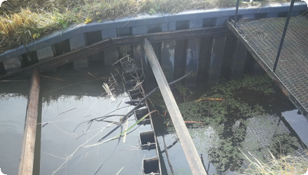
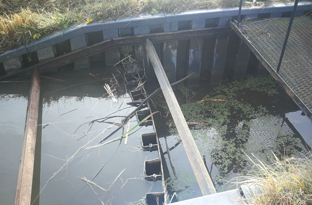
Wetland constructed by artificially flooding the valley, incorporating structural elements such as corrugated metal plating at the inlet and outlet of the wetland to protect the stream banks. |
There are no funds form CAP for this measures. It may be funding upon application from diverse programmes, from Ministry of Agriculture or Ministry of Environment, NGO's or Environment Protection Agency.
Details of the costs
| Authority name | Type of funding | Financing share | Comments | |
|---|---|---|---|---|
|
Other
|
EEA grant
|
The artificial wetland implemented in the Dotnuvelė River basin is part of a catchment-based and project-based initiative aimed at reducing nutrient pollution, particularly nitrogen and phosphorus, from agricultural runoff. The primary policy objective is to improve water quality in line with the EU Water Framework Directive. The measure aligns with broader agriculture and environmental policy goals, focusing on water management and protection. It also contributes to several other European directives and strategies, including the Nitrates Directive, EU Biodiversity Strategy and Habitats Directive, Floods Directive, and the EU Common Agricultural Policy (CAP).
| Wider plan type | Wider plan focus | Name | Comments | |
|---|---|---|---|---|
|
Catchment-based
|
Water
|
EU Water Framework Directive
|
The artificial wetland in the Dotnuvelė River basin is part of a catchment-scale effort to reduce nutrient pollution from agricultural runoff and improve water quality in alignment with the EU Water Framework Directive.
|
| Target purpose | |
|---|---|
|
Pollutants Removal
|
| Impact directive | Relevant impact | |
|---|---|---|
| Pressure directive | Relevant pressure | |
|---|---|---|
| Requirement directive | Specification | |
|---|---|---|
|
Water Framework Directive (WFD) 2000/60/EC
|
||
|
Nitrate Directive (NiD) 91/676/EEC
|
||
|
The Birds and Habitat Directives
|
Habitats Directive 92/43/EEC
|
|
|
Floods Directive-mitigating Flood Risk
|
| Arrangement type | Responsibility | Role | Name | Comments | |
|---|---|---|---|---|---|
| Activity stage | Name | Key issues | Comments |
|---|
| Policy area type | Policy area focus | Name | Comments | |
|---|---|---|---|---|
|
Primary
|
Water Framework Directive
|
Reduce nutrient pollution (particularly nitrogen and phosphorus) from agricultural runoff in alignment
|
||
|
Primary
|
Water Framework Directive
|
Water management and protection
|
||
|
Primary
|
Environmental Policy
|
Environmental protection
|
||
|
Primary
|
Nutrient Directive
|
Monitoring system
Wetland maintenance varies annually. Activities like sediment removal, plant trimming, or replanting (especially post-winter) are done as needed. The project team UAB "Aplinkos inžinierių grupė" is responsible for maintenance during the project period. Afterward, local farmers or community members will take over. The land user incurs no maintenance or setup costs, making the project cost-efficient. Formal monitoring is conducted through reports.
| Success factor type | Success factor role | Comments | Order |
|---|---|---|---|
|
Attitude of relevant stakeholders
|
main factor
|
<p>Stakeholder engagement </p>
|
|
|
Other
|
main factor
|
<p>Tailored design</p>
|
|
|
Available support tools
|
main factor
|
<p>External funding and support </p>
|
| Driver type | Driver role | Comments | Order |
|---|---|---|---|
|
Balancing different objectives
|
main driver
|
Nutrient pollution reduction needs, water quality improvement goals
|
The successful implementation of the wetland measure was driven by strong external funding, stakeholder engagement, and a tailored design adapted to local conditions. These factors enabled cost-effective and efficient execution. However, challenges such as land availability, lack of long-term funding, and unclear responsibilities post-project present risks to long-term sustainability. The project was initiated primarily to address nutrient pollution and improve water quality in the catchment.