| Authority type | Authority name | Role | Comments |
|---|---|---|---|
Climate
Annual Averages:
Geography
Water quality
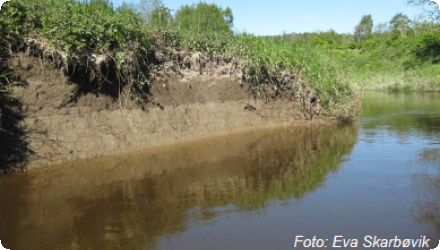
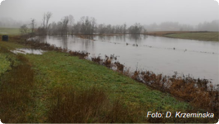
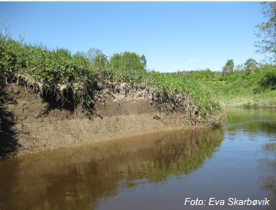
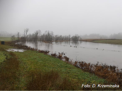
Small agricultural catchment located within the Hobølelva watershed, with 43% of the catchment being agriculture land, dominated by cereal production. The main challenge in the area is water quality (incl. high phosphorus pollution) and soil erosion (incl. riverbank erosion and quick-clay landslides).
Scale of the project
Size of the project
| Land use change type | Comment |
|---|---|
In Norwegian Case study within OPTAIN project we are modeling 6 different measures:
-Reduced tillage (no tillage in autumn & stubble during winter)
-Grass buffer zones alongside waterways in cropland
-Grassed waterways
-Constructed wetlands
-Grass or stubble in areas prone to flooding and erosion
- Small retention ponds in the forest
Cost of implementation and maintenance of these measures can vary greatly depending on their size, location and local conditions.
All listed measures are eligible to the subsidies under region Regional Environmental Programm (RMP) or/and Special Environmental Subsities (SMIL).
More about authorities and financing of measures can be found in the report: https://nibio.brage.unit.no/nibio-xmlui/handle/11250/3129598
Moreover, some design guidelines and example of cost estimation can be found in the NSWRM individual factsheets (OPTAIN measures, see overview section)
| Authority name | Type of funding | Financing share | Comments |
|---|
The agricultural sector has an independent responsibility for environment protection, especially when it comes to sediment and nutrient losses. The National Environmental Programme (NMP) for agriculture provides a comprehensive overview of how the authorities facilitate achieving environmental and climate targets, through agriculture management practices. These includes the mechanism at national, regional and local levels. The National Environmental programme was establishing first in 2004 and it is revised every four years with the intention to ensure that current and emerging environmental and climate considerations are taken into account in agriculture.
Today, surface runoff from fields and ditches is the biggest negative impact factor on the water environment from agriculture. Consequently, the environmental targets set for agricultural sector in Norway are:
- the condition of water bodies in areas dominated by agriculture should not deteriorate.
- water bodies in agriculturally dominated areas that are particularly exposed and polluted, where the condition is to be improved.
These targets require considerable effort from agriculture, therefore there is a need to advocate for efficient and cost-effective mitigation measures targeting environmental challenges in Norwegian agricultural catchments. The most important mitigation measures in agriculture in Norway are management of manure, fertilizer planning, reduced soil tillage, grassed buffer zones along open water, mitigation of point sources and sedimentation ponds.
In addition to measures for reducing losses to water, agriculture also need to reduce emission of greenhouse gases.
Some of these measures have synergies with measures to reduce effects on water quality, like measures for manure, fertilizer use, catch crops, measures to increase carbon storage.
- Farmers and land owners;
- Water boards: local (for the catchment) and regional (for the river basin of Glomma);
- Municipalities;
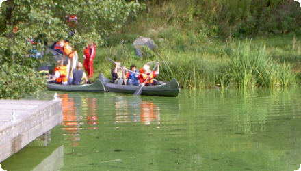
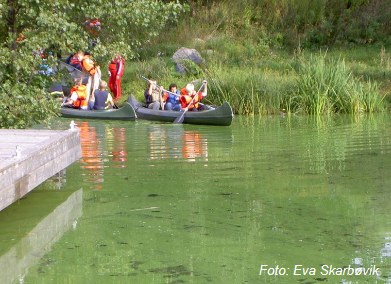
- Boaters, canoes (mainly in the lake), local communities;
- Drinking water supply company (MOVAR);
- Environmentalists (f.ex., SABIMA);
- Hunting and fishing associations;
- Tourist association (Turistforeningen);etc.
| Wider plan type | Wider plan focus | Name | Comments | |
|---|---|---|---|---|
|
Agriculture
|
Common Agriculture Policy
|
| Target purpose | |
|---|---|
|
Erosion Control
|
|
|
Peak-flow reduction
|
|
|
Pollutants Removal
|
|
|
Improved Biodiversity
|
| Impact directive | Relevant impact |
|---|
| Pressure directive | Relevant pressure | |
|---|---|---|
| Requirement directive | Specification | |
|---|---|---|
|
Nitrate Directive (NiD) 91/676/EEC
|
NOTE: we do not follow this directives directly in Norway, but our national environmental targets are in agreement with EU directives
|
|
|
Water Framework Directive (WFD) 2000/60/EC
|
NOTE: we do not follow this directives directly in Norway, but our national environmental targets are in agreement with EU directives
|
| Arrangement type | Responsibility | Role | Name | Comments |
|---|
| Activity stage | Name | Key issues | Comments | |
|---|---|---|---|---|
|
Screening phase
|
MARGs workshops
|
| Policy area type | Policy area focus | Name | Comments | |
|---|---|---|---|---|
|
Primary
|
Water Framework Directive
|
Water Resource act (Vannressursloven)
|
||
|
Primary
|
Environmental Policy
|
National Environmental Program (NMP)
|
||
|
Primary
|
Climate change adaptation policy
|
The Land Act (Lov om jord)
|
In case of some measures there are strict rules about maintenance, and granting of the subsidies depends on following these rules. Other than that, it is up to farmer to maintain implemented measures. In some cases it is possible to get additional grants, from SMIL program to (partly) cover the maintenance costs.
There is no strict rules regarding monitoring of the implemented measures. However, most of measures that are in focus for Norway within OPTAIN project are subject to research activities covering the whole operationalization cycle:
− design - including dimensioning, designing for processes etc.
− optimization of measure(s) location within the catchment
− design and implementation of monitoring programme
− modeling effectiveness of the measures at different spatial and time scales
− forecast the processes and effectiveness of the measures in the future.
| Success factor type | Success factor role | Comments | Order |
|---|---|---|---|
| Driver type | Driver role | Comments | Order |
|---|---|---|---|
In OPTAIN project as modelling study - not applicable.
Hovewer, the project result in increase of knowledge about potential optimal location and dimensioning of measures and their possible combined effect at the catchment scale.
- Farmers and land owners;
- Water boards: local (for the catchment) and regional (for the river basin of Glomma);
- Municipalities;
- Boaters, canoes (mainly in the lake), local communities;
- Hunting and fishing associations;
- Tourist association (Turistforeningen);etc.