Last update
2025
Summary
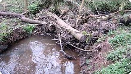
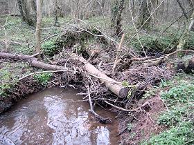
The Slowing the Flow at Pickering project (2009–2015) set out to reduce flood peaks in Pickering, North Yorkshire, by harnessing natural processes across the Pickering Beck catchment. Key measures - four low-level earth bunds, over 160 leaky woody dams, moorland and forest drain‐blocking, riparian and farm woodland planting, sediment traps and no‐burn buffer zones - were installed to slow runoff, boost infiltration and store water temporarily.
Launched after costly floods in 1999-2007, the scheme offered a cheaper, landscape-scale alternative to hard defences. In 2015’s Boxing Day storm, none of the dozens of at-risk properties flooded, demonstrating the network’s effectiveness under extreme rainfall.
After the official end of the project in 2015, the site remained monitored. More recently, beavers have been introduced into a fenced adjacent catchment to work alongside leaky dams-early observations suggest they enhance dam stability and create richer wetland habitats. All measures remain in place, with ongoing monitoring and targeted maintenance ensuring sustained performance.
The site still has not been affected by a storm event of sufficient intensity to demonstrate the expected effectiveness of the measures to their full extent.
Position
Latitude
54.25
Longitude
-0.77
Project
NWRM
National Id
UK_03
Installation date
2011, 2015
Implementation Status
Contact
Alistair McVittie, SRUC
RBD code
UK04
Transboundary
0
Photo gallery
Location of the project
Pickering, North Yorkshire.
NUTS Code
UKE2 - North Yorkshire
Project's objectives
Reduce flood risk and protect the populations from floods.
Demonstrate the effectiveness of natural flood management methods compared to traditional grey infrastructures.
Demonstrate the effectiveness of natural flood management methods compared to traditional grey infrastructures.
Involved Partners
| Authority type | Authority name | Role | Comments |
|---|---|---|---|
Climate zone
cool temperate moist
Temperature
9.6°C
Annual rainfall range
600 - 900 mm
Runoff coefficient
0.3 - 0.5
Runoff range
300 - 450 mm
Elevation range
60-200 m
Slope range
10 - 15%
Soil type
Gleysol
Vegetation class
Forest vegetation : High trees (pines, spruces)
Water bodies: Ecological Status
Moderate
Water bodies: Chemical Status
Good
Water quality status
From the 2nd River Basin Management Plans data (2016)
Project scale
Large
Project scale specification
Project applied across a 68.6km2 catchment.
Performance timescale
1 - 4 years
Project area
6860
Lifespan
50
The main principle of the project is to achieve flood risk management using natural processes. This involves developing an understanding of how land use and management across the entire catchment contribute to flood risk. The project is also concerned with wider environmental, economic and social benefits. These include improved water quality, provision of new and/or improvement of existing habitats, enhanced carbon sequestration, enhanced local skill base in estate management, improved recreation/tourism access and increased public understanding and engagement in land management for flood risk reduction.
Protect 50 properties against a 1 in 25 year flood event.
Design capacity description
Low level bunds: 85000 m^3 flood storage
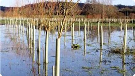
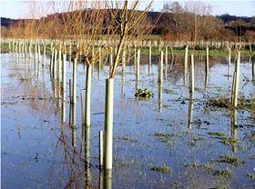
Riparian woodland: 15000 to 53000 m^3 flood volume reduction (0.8 to 2.2 cumecs peak flow reduction)
Floodplain woodland: 14% increase in storage (20 minute flood peak delay)
Riparian woodland: 15000 to 53000 m^3 flood volume reduction (0.8 to 2.2 cumecs peak flow reduction)
Floodplain woodland: 14% increase in storage (20 minute flood peak delay)
The river channel is incised/deep which has led to disconnection from its floodplain. The low level bunds therefore require an artificial structure (pipe bridge) to ensure their effectiveness.
The presence of the historical steam train line in Pickering partially built on a fragile enbankement means more risks to take into account when designing projects having an hydrological impact.
The presence of the historical steam train line in Pickering partially built on a fragile enbankement means more risks to take into account when designing projects having an hydrological impact.
The key factor that influenced the choice of site was the nature of land ownership with around half the area owned by either the public sector (Forestry Commission and the North York Moors National Park Authority) or the Duchy of Lancaster Estates.
Mapping data and catchment models from previous research had been used to identify sites for low level bunds. This research also involved stakeholder engagement which may have been important in overcoming barriers.
Opportunity mapping for woodland creation for flood risk reduction had also been undertaken.
Negative influence effectiveness
The river channel is incised/deep which has led to disconnection from its floodplain. The low level bunds (N1) therefore require an artificial structure (pipe bridge) to ensure their effectiveness.
Total cost
1580000
Costs investment
1580000
Costs investment information
€1.32m : low level bunds
€17,951 : riparian woodland (€2070/ha for native broadleaved, plus €2300/ha for flood risk management)
€27,782 : large woody debris dams (labour costs)
€17,951 : riparian woodland (€2070/ha for native broadleaved, plus €2300/ha for flood risk management)
€27,782 : large woody debris dams (labour costs)
Costs maintenance information
Large woody debris dams are expected to need ongoing maintenance, the costs are not specified
Information on Economic costs other annual
The ecosystem services assessment estimated increaed forestry costs of €620,000 over 100 years
Information on Economic costs - income loss
An ecosystem services assessment estimated impacts of 85ha of woodland creation and 150 large woody debris dams but not the storage bunds. This is a higher area of woodland than actually planted. The estimated loss of agricultural production was €36326 per year or €1047000 over 100 years.
Financing authorities
Type of funding
National funds
Comments
Note that a large part of the local funding will have come from national funding allocations (e.g. block grants) to local authorities
Type of funding
National funds
Type of funding
National funds
Type of funding
Sub-national funds
Type of funding
Local funds
Type of funding
Local funds
Compensations
0
Compensations annual information
No specific compensation is discussed in the project documentation, but it is noted that given potential losses of agricultural output, compensatory payments may be necessary to ensure sufficient uptake of some measures.
Policy context
The town of Pickering in North Yorkshire has a history of flood events, most recently in 1999, 2000, 2002 and 2007; the last of these causing an estimated £7m (€8.05m) of damage. The Slowing the Flow at Pickering project was one of three pilot projects funded by under Defra's multi-objective flood management demonstration programme. A flood alleviation capital scheme was also proposed but deemed unaffordable under current national cost-benefit thresholds.
Land ownership
Most is public ownership or management (Forestry agency, national park authority, ministry of defense, English crown)
Community involvment
No
Design consultation activity
| Activity stage | Name | Key issues | Comments |
|---|---|---|---|
|
Design phase
|
Public meeting
|
Flooding: can local knowledge make a difference? Exhibition held at Pickering Memorial Hall by the Ryedale Flood Research Group. Around 200 people attended the exhibition and were able to read about the group's work, watch video clips, talk to group members and try their hand at modelling
|
|
|
Design phase
|
Public meeting
|
Community engagement event. This public event in the Memorial Hall Pickering, was held to enable the project team to engage the community and stakeholders and involve them with identifying and implementing solutions on the ground.
|
|
|
Implementation phase
|
Media releases
|
Variey of media (web, press, radio) coverage at local/regional and national levels
|
Policy target
| Target purpose |
|---|
|
Increase Water Storage
|
|
Peak-flow reduction
|
Policy pressure
| Pressure directive | Relevant pressure |
|---|---|
|
Floods Directive identified pressure
|
Natural Exceedence
|
Pressures remarks
This project pre-dated transposition of the Flood Directive into UK law.
Policy impact
| Impact directive | Relevant impact |
|---|---|
|
Floods Directive identified impact
|
Property
|
Requirement directive
| Requirement directive | Specification |
|---|---|
|
Floods Directive-mitigating Flood Risk
|
Policy challenges requirements
The Pitt Review of the 2007 floods in England and Wales called for Defra, the Environment Agency and Natural England to work with partners to deliver flood risk management involving greater working with natural processes.
Contractual arrangements
0
| Arrangement type | Responsibility | Role | Name | Comments |
|---|
Part of wider plan
0
Wider plan type
| Wider plan type | Wider plan focus | Name | Comments |
|---|
The catchments are subject to existing and routine hydrological monitoring and assessment for WFD compliance. Additional monitoring may occur during potential flood events.
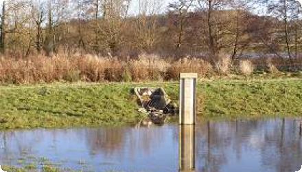
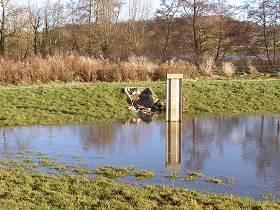
Recording of water levels at different points (upstream and downstream from some measures)
Maintenance
Depends on the measures, and the available funds.
Unknown
Impacts have currently only been assessed using hydrological models comparing pre and post implementation scenarios.
The costs of measures have been based on estimated capital costs, woodland grant payments and labour costs. Maintenance and replacement costs are not taken into account, yet they could weigh significantly on long term costs.
Benefits estimates for flood regulation are based on the actual costs (2007) or estimated per property flooded costs (2000) of previous flood events adjusted by flood return periods and extent of alleviation offered by measures.
Other ecosystem service benefits are estimated using a variety of approaches.
The overall assessment is based on a cost-benefit test of net present values of benefits over 100 years.
The severe flooding of 2007 caused an estimated €8.05m of damage to property in the town of Pickering.
All values converted using €1 = £0.87 (average 2011 value).
All values converted using €1 = £0.87 (average 2011 value).
270450
An ecosystem services assessment estimated impacts of 85ha of woodland creation (F1: riparian, floodplain and farm woodland) and 150 large woody debris dams (F10) but not the storage bunds (N1). This is a higher area of woodland than actually planted.
Mean annual (€/yr)
Habitat creation: 139,683
Flood regulation: 6,855
Climate regulation: 123,029
Erosion regulation: 236
Education and knowledge: 16
Community development: 631
Mean annual (€/yr)
Habitat creation: 139,683
Flood regulation: 6,855
Climate regulation: 123,029
Erosion regulation: 236
Education and knowledge: 16
Community development: 631
Hydrological effects
It reduced peak flows, delayed runoff, increased temporary water storage, and slightly improved infiltration and baseflows, helping smooth the hydrological response during storms without major changes to the overall water balance.
Information on increased water storage
Source reference gives estimated total storage without time values, these range from 90000 to 138000 m3
Information on runoff reduction
Sites were identified using modelling for two low level bunds between 1.5 and 2.5m in height, this would provide 85,000m3 of flood storage sufficient for the flood events of 1999, 2000 and 2002. Larger events such as 2007 would require 650,000m3of additional storage. The river channel was too incised/deep for the bunds to be effective so these were designed to operate in conjunction with a pipe bridge to constrict flow and reconnect the river with its floodplain.
Based on estimated peak flow reductions, the joint impact of 50 ha of riparian woodland planting and 100 large wood debris dams is estimated at between 15,000 and 53,000m3 for the 2000 and 2007 flood events respectively. However new planting of woodland was only considered to be acceptable at only 4 sites covering 4.1ha. From the source it is not possible to disaggregate the impacts of measures F1 and F10 so care is advised in using these values.
Based on estimated peak flow reductions, the joint impact of 50 ha of riparian woodland planting and 100 large wood debris dams is estimated at between 15,000 and 53,000m3 for the 2000 and 2007 flood events respectively. However new planting of woodland was only considered to be acceptable at only 4 sites covering 4.1ha. From the source it is not possible to disaggregate the impacts of measures F1 and F10 so care is advised in using these values.
Information on Peak flow rate reduction
Mean estimated combined impact of riparian woodland and woody debris dams, range of 6.7% to 14.7% depends on size of flood event.
The combined peak flow reductions of for a modelled 50ha of riparian woodland and 100 large wood debris dams was estimated at 0.8 and 2.2 cumecs for the 2000 and 2007 flood events respectively. However new planting of woodland was only considered to be acceptable at only 4 sites covering 4.1ha.
The combined peak flow reductions of for a modelled 50ha of riparian woodland and 100 large wood debris dams was estimated at 0.8 and 2.2 cumecs for the 2000 and 2007 flood events respectively. However new planting of woodland was only considered to be acceptable at only 4 sites covering 4.1ha.
Information on Increased infiltration
Possible increase in infiltration due to flow reduction effects
Information on Soil moisture
Possible increase in soil moisture due to increased retention
Information on Reducing flood risks, quantity
The degree of peak flow rate reduction associated with the low level bunds is dependent on the design of the associated pipe bridge and whether this can restrict a flow of 12 or 15 cumecs. Flows of 12 cumecs are associated with 6 properties being flooded; flows of 15 cumecs would lead to flooding affecting 50 properties.
Reducing flood risks quantity change
The measures have successfully reduced flood peaks in Pickering during moderate to high but non-extreme events. The 2015 Boxing Day flood brought extreme rainfall, and many rivers in the region flooded severely, but in Pickering no properties flooded. The storage bund at Newbridge reached about 85% of its capacity during the event.
Ecosystem flood control return periods
1 in 25
Information on Ecosystem flood control return periods
Floodplain storage has sufficient capactiy for a 1 in 25 year flood event.
Ecosystem erosion control
1
Information on Ecosystem erosion control
Riparian and floodplain woodland should reduce soil erosion.
Water quality overall improvements
Neutral impact-no change in WQ status
Information on Water quality overall improvements
Limited evidence, but likely minor improvements: reduced sediment transport from blocked drains and woodland planting, and better filtration from leaky dams. No major water quality monitoring was done, so impacts remain mostly assumed, not confirmed.
Soil quality overall soil improvements
N/A info
Information on WFD ecological status obj quantity
The project is expected to improve WFD ecological status. The impacts are not specified but could include increased shading and reduced sediment loading due to riparian woodland, and improved habitats from LWD dams.
1
The biodiversity benefits from the Pickering measures are modest but positive. No formal biodiversity index or class shift reported, but anecdotal evidence and local surveys note rises in pollinator species, wading birds, and aquatic invertebrates. Bats and otters also benefited from enhanced woodland cover and watercourse complexity.
The introduction of beavers in an adjacent catchment is being monitored for future biodiversity effects.
The introduction of beavers in an adjacent catchment is being monitored for future biodiversity effects.
Ecosystem impact climate regulation
Increased permanent biomas
Information on Ecosystem impact climate regulation
Increase in woody biomass and soil C storage
Ecosystem provisioning services
0
Information on Ecosystem provisioning services
Loss of agricultural land for riparian and floodplain woodland
Key lessons
Two years was too short for the project. At least 3–5 years are needed for planning, consultation, modelling, and implementation.
Long-term monitoring is essential. Impacts take time to show, and baseline data often comes late. The measures still haven’t faced a 1-in-25-year flood.
A proactive, flexible approach from partners is key. Strong communication and willingness to adapt (e.g., to maintain structures) are essential.
Community engagement: Expectations must be managed realistically. Community involvement worked well, but clearer messaging on NFM limitations is needed.
Locals support whole-catchment natural flood management (NFM), but NFM should be seen as part of a wider flood management strategy, not a stand-alone solution.
Maintenance: Structures like bunds and leaky dams need upkeep. Some have decayed as expected; replacements and natural evolution (e.g. with beavers) help.
Support & policy: Volunteer-led projects need long-term funding and integration into national flood management policy to stay effective.
Success factor(s)
| Success factor type | Success factor role | Comments | Order |
|---|---|---|---|
|
Existing institutional framework
|
main factor
|
<p>Land ownership was relatively concentrated with around 50% of catchment in either public ownership (Forestry Commission and the North York Moors National Park Authority) or the Duchy of Lancaster Estates.</p>
|
1
|
|
Available support tools
|
secondary factor
|
<p>The catchment had been subject to hydrological modelling as part of a previous academic study.</p>
|
2
|
|
Attitude of the public
|
secondary factor
|
<p>Ongoing process of stakeholder and community engagement in both the aims and delivery of the project.</p>
|
4
|
|
Other
|
main factor
|
Land Control was probably the main success factor. There have been unsuccessful attempts to duplicate these measures on sites with multiple private owners, due to the lack of willingness of owners to participate. |
Driver
| Driver type | Driver role | Comments | Order |
|---|---|---|---|
|
Past flooding events
|
main driver
|
A flood alleviation capital scheme was also proposed but deemed unaffordable under current national cost-benefit thresholds.
|
1
|
|
Other
|
main driver
|
Willingness to create a demonstration site to expose and assess the effectiveness of natural flood management methods.
|
Flexibility adaptability
The catchment is subject to ongoing monitoring, including an Environment Agency gauge station in the lower catchment and Forest Research water level recorders in the upper catchment. These will help to monitor baseline conditions and assess the impact of installed measures, in particular riparian woodland and LWD dams.
This may encourage further uptake of measures including better management of existing riparian woodland (in-fill planting, encouraging regeneration).
This may encourage further uptake of measures including better management of existing riparian woodland (in-fill planting, encouraging regeneration).
Transferability
These measures are very transferable to other sites, but special care shall be observed while designing, to avoid land conflicts. Opportunity maps are a good tool for that.
Basin characteristics influence
Pickering Beck iss deeply incised and disconnected from its floodplain. Low bunds (N1) with a pipe bridge and LWD dams (N12) helped reconnect the river by enabling it to spill into adjacent areas.
Cost effectiveness
Most effective measure are timber bunds, as they are very cheap (using local wood). Beaver introduction have a lot of potential, being cheaper in work costs and similar hydrological effectiveness.
English