Last update
2023
Summary
The measures implemented at two river within the city of Hamburg (Germany) included the restoration of rivers and ponds (N1), the revitalization of flowing waters (N5), natural bank stabilization (N10), and channels and rills (U5). They targeted the National Biodiversity Strategy of Germany as well as the achievement of a good ecological status as defined by the WFD. For the identification of locations for possible measures the general public was involved using online forms. The implementation was then carried out by a local chapter of the German nature conservation NGO NABU. This measure proves to be highly effective while easy and cheap to implement, it is therefore considered a success.
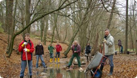
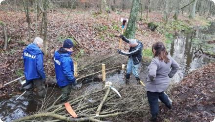
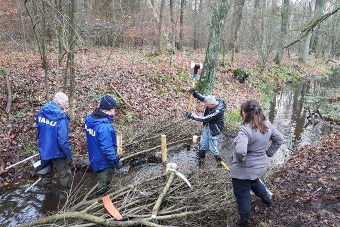
Since 2006, the “Waters Neighborhood Days” evolved into regular Bach-Aktionstage, engaging citizens and school groups in restoring small urban streams in Hamburg. Led by NABU and supported by SDW and local authorities, actions include placing deadwood, adding gravel, and removing concrete structures to improve stream morphology and biodiversity. Over 40 events have taken place across multiple streams, with long-term educational and ecological goals.
Since 2006, the “Waters Neighborhood Days” evolved into regular Bach-Aktionstage, engaging citizens and school groups in restoring small urban streams in Hamburg. Led by NABU and supported by SDW and local authorities, actions include placing deadwood, adding gravel, and removing concrete structures to improve stream morphology and biodiversity. Over 40 events have taken place across multiple streams, with long-term educational and ecological goals.
Position
Latitude
53.600178
Longitude
10.094004
Project
NWRM
National Id
Germany-02
Installation date
2006-02
Implementation Status
Contact
Tamer Fawzy / BEF DE
RBD code
DE5000
Transboundary
0
Photo gallery

Location of the project
The Osterbek river is an inflow of the river Alster in Hamburg. The studied river section is approximately 220 m long and located in a green corridor between allotments, roads and subway tunnels. The left side adjacent park area is a regularly mowed lawn, which also serves as an emergency overflow for a culvert of the Osterbek river. The Copse is light on both sides of the river. The middle Bille is part of the water system Bille, which flows into the Elbe river. The considered 150 m long section is located in a green belt. Left-sided runs a water-bound walk, on the right side residential blocks and a park are located at different distances.
NUTS Code
DE60 - Hamburg
Involved Partners
| Authority type | Authority name | Role | Comments |
|---|---|---|---|
Climate zone
cool temperate moist
Temperature
9
Annual rainfall range
0 - 300 mm
Runoff range
600 - 750 mm
Slope range
moderately steep (15-30%)
Vegetation class
Riparian & aquatic vegetation
Project scale
Micro
Project scale specification
Small river sections of about 200m. At least 8 streams affected: Kampbille, Schleemer Bach, Osterbek, Seebek, Rahlau, Saselbek, Furtbek, Kollau ; over 40 events.
Performance timescale
< 1 year
Size
370
Size unit
m
Lifespan
5
Low costs, functionality, adaptability
Design capacity description
N.A.
The waters neighborhood days were initiated in 2005 by the Project Manager group for water protection at NABU Hamburg. Guided by their own vision to actively improve the water body structure of streams in Hamburg, also in times of scarce public resources, this particular collaboration was launched. It consisted of the project managers, NABU Hamburg, volunteers, Rückenwind e.V. and the competent district office (civil division).
Total cost
1270
Costs investment
1270
Costs investment information
Through the volunteer work of the project as well as the numerous helpers on the one hand and the charitable work of young people on the other hand no additional costs incurred.
This cost only covers the first 2 restored sections of rivers. It has increased since the number of events grew.
This cost only covers the first 2 restored sections of rivers. It has increased since the number of events grew.
Financing authorities
Type of funding
Local funds
Comments
€ 1270 for the first 2 sections which is very low-cost.
Policy context
The basin of the Osterbek river was expanded very widely over the past decades and thereby lost its natural structure. The increased runoff after rain and corresponding management led to a domination of sand in the river bed. Gravel, stones and dead wood are largely absent, so suitable conditions for animal and plant communities are absent.
Due to anthropogenic interventions in the 19th Century the middle Bille was cut off from their natural course. Since then, it is supplied by the Kamp-Bille. In addition rain water flows into it from an outlet from a heavy frequented street.
Due to the highly variable runoff and the narrow, deeply incised river bed with a partially still existing bank stabilization with Bongossi timber, it is a poorly structured river bed that offers no suitable conditions for most animal and plant communities.
The proportion of sand is very high, stones and dead wood only occur sporadically.
Land ownership
Most streams involved (e.g. Schleemer Bach, Seebek, Osterbek, Saselbek) run through public land, including parks, green corridors, and road margins managed by Hamburg’s Bezirksämter (district offices).
Community involvment
No
Design consultation activity
| Activity stage | Name | Key issues | Comments |
|---|---|---|---|
|
Other
|
Via a Form, which is available for download under www.NABU-Hamburg.de/wasser, the interested public can contribute their own proposals for local measures. The proposed measures for the two river sections were developed with the technical assistance of the NABU experts for water protection.
|
Policy target
| Target purpose |
|---|
|
Erosion Control
|
|
Improved Biodiversity
|
|
Runoff control
|
Target Remarks
Biodiversity and gene-pool conservation in riparian areas
Soil formation and maintenance
Mass stabilisation and control of erosion rates
Soil formation and maintenance
Mass stabilisation and control of erosion rates
Policy pressure
| Pressure directive | Relevant pressure |
|---|---|
|
WFD identified pressure
|
2.1 Diffuse - Urban run off
|
Policy impact
| Impact directive | Relevant impact |
|---|---|
|
WFD identified impact
|
Nutrient Pollution
|
|
Floods Directive identified impact
|
Community
|
Requirement directive
| Requirement directive | Specification |
|---|
Policy challenges requirements
National Biodiversity Strategy
Contractual arrangements
0
| Arrangement type | Responsibility | Role | Name | Comments |
|---|
Part of wider plan
1
Wider plan type
| Wider plan type | Wider plan focus | Name | Comments |
|---|---|---|---|
|
National
|
Environment & Biodiversity
|
National Biodiversity Strategy
|
A professionally sound monitoring by the NABU is not possible with these small projects.
Maintenance
The application has to be regularly monitored and maintained due to the use of only natural materials.
Catchment outlet
Monitoring
Hydrological effects
A variability of flow velocities in low and medium water levels was achieved. It led to both depressions and aggradations in the river bed as well as a sorting of different sediment fractions.
Information on retained water
N.A.
Soil quality overall soil improvements
N/A info
Information on Soil quality overall soil improvements
N.A.
1
River bed serves numerous aquatic organisms as a resting place or shelter during flood events. In them a layer of organic materials is accumulated which serves as a food source.
Ecosystem impact climate regulation
No specific impact
Ecosystem provisioning services
0
Key lessons
After the first flood events it is visible, that the water body structure at the Middle Bille has been significantly improved. Due to different flow speeds and variability of the basin structure a positive short to medium term impact on biodiversity can be assumed.
Success factor(s)
| Success factor type | Success factor role | Comments | Order |
|---|---|---|---|
|
Attitude of the public
|
main factor
|
<p>voluntary work</p>
|
1
|
Driver
| Driver type | Driver role | Comments | Order |
|---|---|---|---|
|
Organisation committed to it
|
main driver
|
Biodiversity and gene-pool conservation in riparian areas
|
1
|
Cost effectiveness
They are assumed to be highly cost-effective, although no quantitative assessment was carried out for this application.
English