Last update
2026
Summary
Sponge Scapes case study NL 02
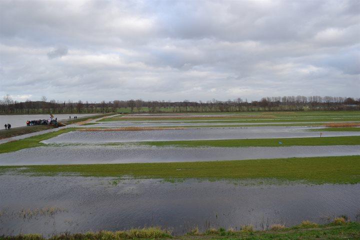
Regional Water Authority Aa and Maas provides a case study in their management area that is located in the wider river basin of the Meuse in south-east of the Netherlands, in the eastern part of the southern province of Brabant in the Netherlands. The area is charactierized by intensive agriculture (crops and livestock) and extensive artificial drainage of agricultural land has been carried out because excessively wet soils are more difficult for farmers to access and cultivate. At the same time the water system is also used to bring water to the agricultural fields from the Meuse river in periods of droughts and original water courses have been heavily modified to provide an efficient network of drainage and water supply, causing challenges for aquatic and riparian ecosystems.
Regional Water Authority Aa and Maas provides a case study in their management area that is located in the wider river basin of the Meuse in south-east of the Netherlands, in the eastern part of the southern province of Brabant in the Netherlands. The area is charactierized by intensive agriculture (crops and livestock) and extensive artificial drainage of agricultural land has been carried out because excessively wet soils are more difficult for farmers to access and cultivate. At the same time the water system is also used to bring water to the agricultural fields from the Meuse river in periods of droughts and original water courses have been heavily modified to provide an efficient network of drainage and water supply, causing challenges for aquatic and riparian ecosystems.
Position
Latitude
51.3645
Longitude
5.5357
Project
SpongeScapes
Transboundary
0
Photo gallery


Location of the project
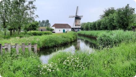
The Aa and Maas catchment (15 km2) is located in the wider river basin of the Meuse in south-east of the Netherlands, in the eastern part of the southern province of Brabant in the Netherlands. It is a agricultural province (crops and livestock). In this agricultural catchment area, as elsewhere in Europe, extensive artificial drainage of agricultural land has been carried out because excessively wet soils are more difficult for farmers to access and cultivate. But this in turns has led to a loss of storage capacity in the soils.
NUTS Code
NL41 - Noord-Brabant
Project's objectives
The regional water authority Waterschap Aa en Maas is continuously working on improving its water systems both for making it more resilient to climate change in terms of water quantity management and at the same time works on improving of the water quality and ecological values in line with the objectives of the Water Framework Directive. There is a large and diverse group of stakeholders related to this integrated water management and with limited space available there is a clear need to see beyond single measures to a wider catchment perspective of linking individual measures into overarching strategies, that take into account both the need to retain and provide water to end-users and at the same time improve the water quality and ecological status.
There is a high interest from the case owner, the regional water authority Aa and Maas, to further upscale visioning of sponge strategies in co-design with local stakeholders, including provincial government, other regional water authorities in the region, WWF-NL and local landowners / farmers organisations.
There is a high interest from the case owner, the regional water authority Aa and Maas, to further upscale visioning of sponge strategies in co-design with local stakeholders, including provincial government, other regional water authorities in the region, WWF-NL and local landowners / farmers organisations.
Involved Partners
| Authority type | Authority name | Role | Comments |
|---|---|---|---|
Climate zone
cool temperate moist
Project scale
Meso
Project scale specification
catchment
Project area
15 km²
Area specifications
The area is characterized by intensive agriculture (crops and livestock). Extensive artificial drainage of agricultural land has been carried out because excessive wet soils are more difficult for farmers to access and cultivate. Over the years, the river system has been heavily modified to provide an efficient network of drainage and water supply, causing challenges for aquatic and riparian ecosystems, but also combatting drought events in the region.
Policy context
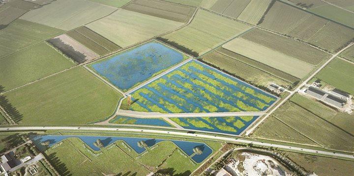
The case study serves as a SpongeLab, emphasising participatory processes in the design and evaluation of sponge strategies (combinations of sponge measures at the landscape scale). Workshops will be conducted to generate spatial scenarios and collaboratively assess potential impacts. We will explore combinations of linear and area-based measures to optimise and improve overall landscape resilience to climate extremes and improve the ecological values in the area.
Land ownership
Waterschap Aa en Mass
Community involvment
No
Design consultation activity
| Activity stage | Name | Key issues | Comments |
|---|---|---|---|
Policy target
| Target purpose |
|---|
Policy pressure
| Pressure directive | Relevant pressure |
|---|---|
Policy impact
| Impact directive | Relevant impact |
|---|---|
Requirement directive
| Requirement directive | Specification |
|---|---|
Contractual arrangements
0
| Arrangement type | Responsibility | Role | Name | Comments |
|---|---|---|---|---|
Part of wider plan
0
Wider plan type
| Wider plan type | Wider plan focus | Name | Comments |
|---|---|---|---|
High-density, innovative real-time online monitoring of water quantity and water
quality has been implemented since 2018 to inform participating landowners about the impact of their farming practices on soil and water quality.
quality has been implemented since 2018 to inform participating landowners about the impact of their farming practices on soil and water quality.
Success factor(s)
| Success factor type | Success factor role | Comments | Order |
|---|---|---|---|
Driver
| Driver type | Driver role | Comments | Order |
|---|---|---|---|
English