Last update
2026
Summary
Sponge Scapes case study UK 04
Natural Flood Management was trialled in Littlestock Brook (16 km²) in the Evenlode catchment during a 5-year project (2016-2021). It was one of the first of its kind in the Thames Basin.
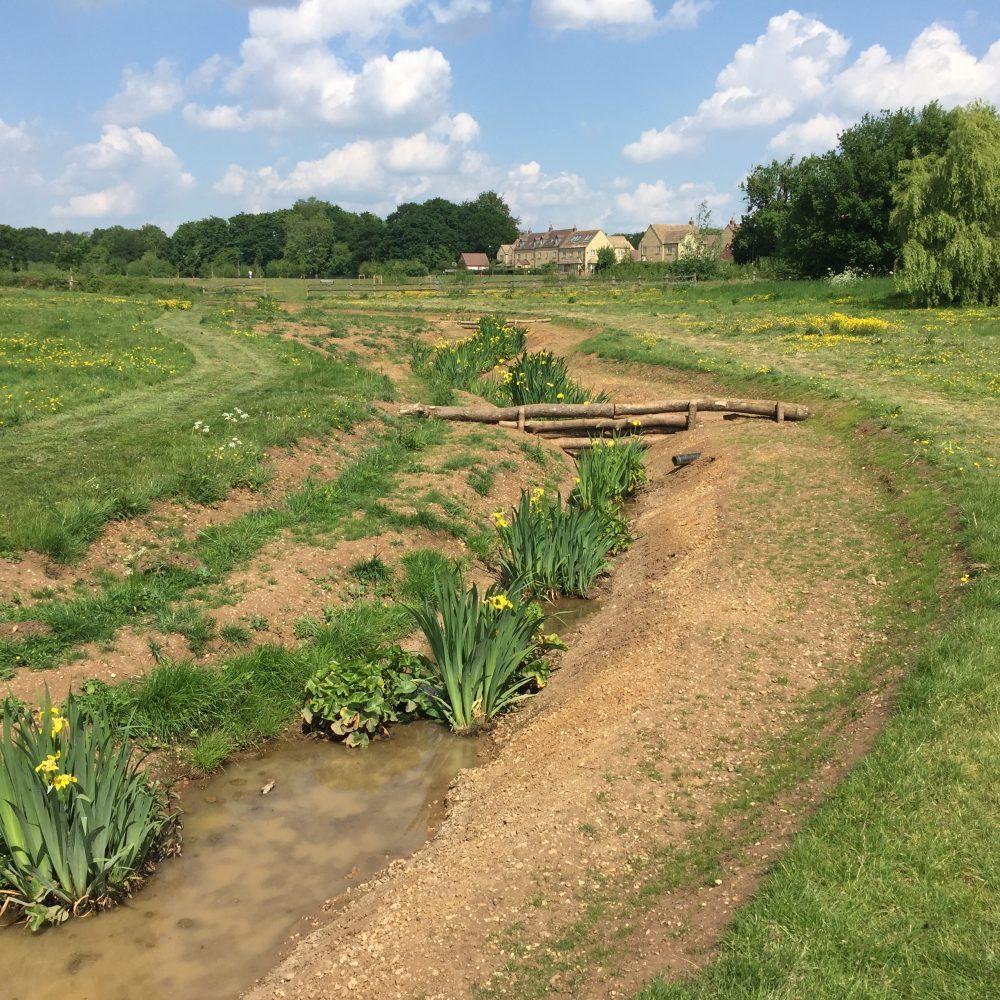
The measures aimed to retain and store more water across the catchment to slow the flow (through field corner bunds, woodland planting, leaky woody dams and inline ponds) and improve water quality, ecosystems services, habitats and carbon sequestration (through nutrient retention ponds, planting of riparian woodland, restoration of wetlands).
Natural Flood Management was trialled in Littlestock Brook (16 km²) in the Evenlode catchment during a 5-year project (2016-2021). It was one of the first of its kind in the Thames Basin.
The measures aimed to retain and store more water across the catchment to slow the flow (through field corner bunds, woodland planting, leaky woody dams and inline ponds) and improve water quality, ecosystems services, habitats and carbon sequestration (through nutrient retention ponds, planting of riparian woodland, restoration of wetlands).
Position
Latitude
51.5144
Longitude
1.3844
Project
SpongeScapes
Installation date
2017-2019
Implementation Status
Contact
ann@wildoxfordshire.org.uk
Transboundary
0
Photo gallery

Location of the project
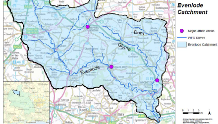
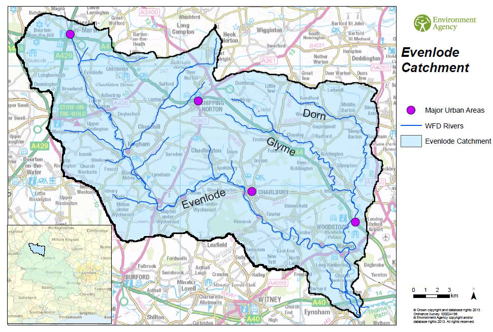
The River Evenlode rises near Moreton-in-Marsh, Gloucestershire, and is a headwater tributary of the River Thames, with a catchment area of approximately 430km². The landscape is predominantly agricultural, consisting of arable land, grassland and woodland.
Land drainage in particular has resulted in the straightening of the river channel, and some of the local villages are at high risk of flooding due to the altered and restricted course of the river. The catchment also suffers from degradation due to pollution from waste water and agricultural runoff. The clay soils of the Evenlode headwaters are an important landscape feature of the north west of the catchment. The increase in impervious surfaces (roads, housing) and the compaction of soils from heavy farm machinery reduce the amount of water that can infiltrate into the subsurface soils, resulting in increased flood risk.
Land drainage in particular has resulted in the straightening of the river channel, and some of the local villages are at high risk of flooding due to the altered and restricted course of the river. The catchment also suffers from degradation due to pollution from waste water and agricultural runoff. The clay soils of the Evenlode headwaters are an important landscape feature of the north west of the catchment. The increase in impervious surfaces (roads, housing) and the compaction of soils from heavy farm machinery reduce the amount of water that can infiltrate into the subsurface soils, resulting in increased flood risk.
Project's objectives
The objective is to improve our understanding of working with natural processes for flood risk management in an agricultural landscape. Natural Flood Management (NFM) was trialled in Littlestock Brook (16 km2) in the Evenlode catchment during a 5-year project (2016-2021). It was one of the first of its kind in the Thames Basin. The measures aimed to retain and store more water across the catchment to slow the flow (through field corner bunds, woodland planting, leaky woody dams and online ponds) and improve water quality, ecosystems services, habitats and carbon sequestration (through nutrient retention ponds, planting of riparian woodland, restoration of wetlands).
Involved Partners
| Authority type | Authority name | Role | Comments |
|---|---|---|---|
Climate zone
cool temperate moist
Project scale
Micro
Project area
16 km²
Area specifications
The landscape is predominantly agricultural, consisting of arable land, grassland and woodland. Land drainage has resulted in the straightening of the river channel, and some of the local villages are at high risk of flooding due to the altered and restricted course of the river. The catchment also suffers from degradation due to pollution from wastewater and agricultural runoff. The clay soils of the Evenlode headwaters are an important landscape feature of the northwest of the catchment. The increase in impervious surfaces (roads, housing) and the compaction of soils from heavy farm machinery reduce the amount of water that can infiltrate into the subsurface soils, resulting in increased flood risk.
Area subject to Land use change or Management/Practice change (ha)
Crop land, grassland, urban
Design capacity description
Design objectives: Reduce flood risk to town house downstream and reduce waterlogging in farm land
Costs total information
UK environmental Agency and Agri-Environment Schemes did fund this project
Land ownership
Wild Oxfordshire (Evenlode Catchment Partnership, ECP, host organisation)
Community involvment
No
Design consultation activity
| Activity stage | Name | Key issues | Comments |
|---|---|---|---|
Policy target
| Target purpose |
|---|
Policy pressure
| Pressure directive | Relevant pressure |
|---|---|
Pressures remarks
Land drainage in particular has resulted in the straightening of the river channel, and some of the local villages are at high risk of flooding due to the altered and restricted course of the river. The catchment also suffers from degradation due to pollution from waste water and agricultural runoff. The clay soils of the Evenlode headwaters are an important landscape feature of the north west of the catchment. The increase in impervious surfaces (roads, housing) and the compaction of soils from heavy farm machinery reduce the amount of water that can infiltrate into the subsurface soils, resulting in increased flood risk.
Policy impact
| Impact directive | Relevant impact |
|---|---|
Requirement directive
| Requirement directive | Specification |
|---|---|
Contractual arrangements
0
| Arrangement type | Responsibility | Role | Name | Comments |
|---|---|---|---|---|
Part of wider plan
0
Wider plan type
| Wider plan type | Wider plan focus | Name | Comments |
|---|---|---|---|
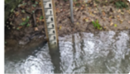
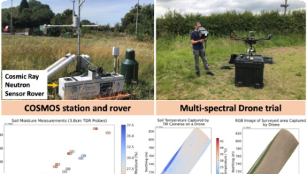
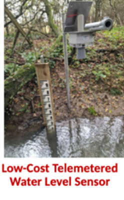
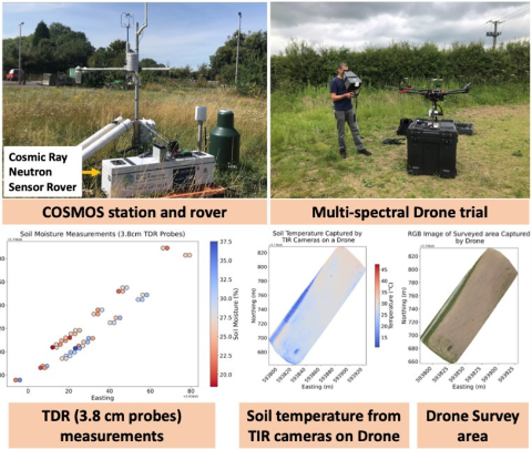
Water level, rainfall, soil moisture, soil survey (soil organic matter, saturated hydraulic conductivity (Ksat, bulk density, water retention characteristics) ),
Long-term hydrological data (1970-) and calibrated hydrological models. Data was collected by the NFM project since 2016 including: measured water levels, flows, turbidity, sediment and nutrients, pond vegetation and macroinvertebrate species. SpongeScapes extends previous monitoring with a combination of low-cost and high-tech monitoring to analyse the impacts from the plot scale (monitor water and sediment trapping efficiency, likely to change with stream geomorphic evolution and further vegetation development) to the catchment scale (gauge data and modelling).
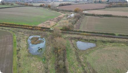
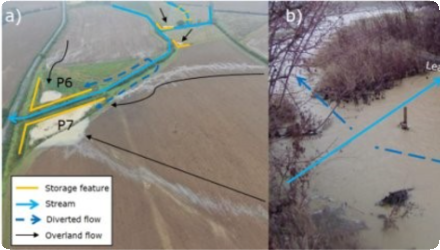
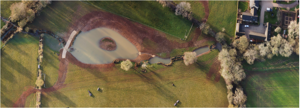
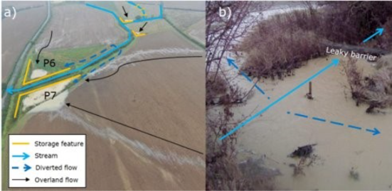
Within the broader Littlestock Brook (LB) Natural Flood Management (NFM) project started in 2017, SpongeScapes is monitoring in detail NFM measures in Zone A of the south branch of LB (LBSB).
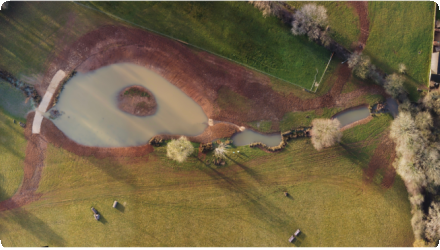
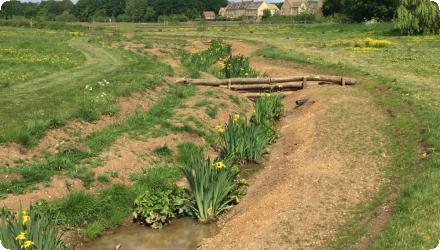
Namely, they monitor a segment (zone A) of the LBSB that encompasses 4 field corner bunds, 3 inline ponds, plantations of wet woodland and 3 woody leaky dams, for understanding the integrated effect of all these measures together on downstream water level and flow. They also monitor water level and flow for overall LBSB and north branches (though not completely similar, they approximate to paired subcatchments where LBSB has the NFM measures while northern branch acts as comparison) just upstream of the village to study overall impact of the NFM project on flooding on homes.
Even more specifically, they monitor the water level, aquatic macroinvertebrate and macrophyte families in two of the three inline ponds, the largest corner bund, and several reaches of the LBSB in Zone A. They also monitor water temperature and light in ponds, bund and stream, and sediment deposition in the 3 inline ponds and the largest bund.
There are rainfall gauges in Zone A upstream and by the village downstream.
Additionally -and to link to runoff from uplslope fields (and our other ag sites in the Thames basin)-, they monitor soil moisture hourly in vertical profiles in 3 locations, and do seasonal soil surveys (bulk density, soil organic matter, water retention characteristics, infiltration and percolation rates).
The monitoring was effectuated from 2019 (water level, rainfall, soil mosture and soil surveys) to 2023 (for soil moisture) and 2024 (for soil surveys) by the UK centre for Ecology and Hydrology.
Within the broader Littlestock Brook (LB) Natural Flood Management (NFM) project started in 2017, SpongeScapes is monitoring in detail NFM measures in Zone A of the south branch of LB (LBSB).
Namely, they monitor a segment (zone A) of the LBSB that encompasses 4 field corner bunds, 3 inline ponds, plantations of wet woodland and 3 woody leaky dams, for understanding the integrated effect of all these measures together on downstream water level and flow. They also monitor water level and flow for overall LBSB and north branches (though not completely similar, they approximate to paired subcatchments where LBSB has the NFM measures while northern branch acts as comparison) just upstream of the village to study overall impact of the NFM project on flooding on homes.
Even more specifically, they monitor the water level, aquatic macroinvertebrate and macrophyte families in two of the three inline ponds, the largest corner bund, and several reaches of the LBSB in Zone A. They also monitor water temperature and light in ponds, bund and stream, and sediment deposition in the 3 inline ponds and the largest bund.
There are rainfall gauges in Zone A upstream and by the village downstream.
Additionally -and to link to runoff from uplslope fields (and our other ag sites in the Thames basin)-, they monitor soil moisture hourly in vertical profiles in 3 locations, and do seasonal soil surveys (bulk density, soil organic matter, water retention characteristics, infiltration and percolation rates).
The monitoring was effectuated from 2019 (water level, rainfall, soil mosture and soil surveys) to 2023 (for soil moisture) and 2024 (for soil surveys) by the UK centre for Ecology and Hydrology.
- Runoff attenuation: For similar event of July 2007 flood, no houses flooded,
- Hydrological connectivity: System of woody leady dam - floodpain- bunds works,
- Reduce eorsion and Sediment reduction: Field eroded sediment reduced and captured (ponds, bunds),
- Create/ restore aquatic habitat: Online ponds, fileds corner buunds,
- Create/ restore riparian habitat: woody lealy dams, wet woodland,
- Create/ restore terrestrial habitat: Wet woodland, meadows,
- Absorb CO2: increased soil organic matter,
- Landscape/ amenity: increased walkers and visitors in general/ Exemplar used for natural flood management benefits dissemination.
Change of soil use --> Crop production: reduced cropland (though less productive due to waterlogging)
Key lessons
The main factors influencing site selection and intervention design were engaged landowners, biophysical context and the Agri-Environment Schemes funding sources.
As one of the first NFM projects in the Thames basin, it increases our understanding of the effectiveness of working with natural processes for flood risk management in a lowland agricultural landscape. Hydraulic modelling results show that the new measures reduce the severity of flooding to 12 properties for a range of flood events.
A comprehensive monitoring network of water levels, sediment and nutrient fluxes in heavy-rainfall events has generated detailed evidence on the effectiveness of these features for reducing flood risk and providing wider ecosystem services of improving water quality, habitat, and carbon storage.
Success factor(s)
| Success factor type | Success factor role | Comments | Order |
|---|---|---|---|
Driver
| Driver type | Driver role | Comments | Order |
|---|---|---|---|
English