- Keylines
Keyline Design is a landscape management and regenerative agriculture tillage technique to optimise the use of water resources developed in the 1950s in Australia. The basic principle of keyline design is to create structures in the terrain that ensure that the water available from precipitation is absorbed, distributed and stored on the land in the best possible way.
A central concept is the key point, a specific point in a valley where the slope begins to level out. A contour line is drawn through this point to guide ploughing and water management. In practical terms, this is where water tends to collect as the slope changes from concave to convex. Typically, the key point is found about a third of the way up the valley.
Another key principle is the Scale of Permanence, a framework to classify landscape elements according to their permanence. It prioritises factors such as climate, land form, water, roads, trees, structures, fencing and soil.
Cultivation in Keyline Design follows the Keyline itself, with tillage carried out in parallel lines. Fascines can also be implemented at regular intervals along the slope. This approach helps to increase water infiltration and reduce erosion.
Keyline Design has several practical applications:
Water management: Canals and ponds are constructed to distribute water efficiently across the landscape.
Agroforestry: Trees are planted along keylines, sometimes also small swales along the trees or fascines, to increase infiltration, reduce erosion, improve biodiversity, stabilise soil and support microclimates.
Soil regeneration: Techniques such as subsoiling or Mulching improve soil structure and increase water retention.
Riverbank restoration: Techniques such as riverbank stabilisation or elimination of grey river bank protection using a.o. fascines decrease erosion, stabilise riverbank and slow down runoff.
Although qualitative comparisons have shown positive effects in terms of reduced erodibility and improved runoff infiltration, scientific studies on Keyline Design remain limited, and more research is needed to assess its broader applicability and outcomes across different landscapes and climates.
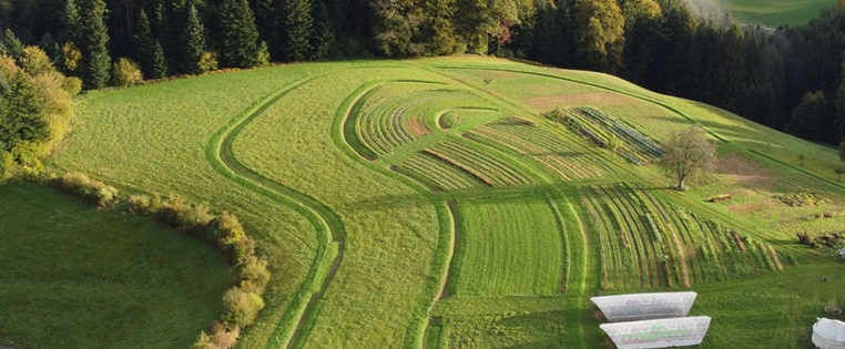
Illustration: Key lines (DE)
Source: Philipp Gerhardt -...
