Last update
2025
Summary
The project’s objective was to improve the conservation status of aquatic bird species in Lower Prut Floodplain Natural Park (Galați County, RO) through scientific inventory, monitoring, site restoration, awareness-raising, implementation of the park management plan, and the designation of Natura 2000 SPAs. Partners were the University of Bucharest, the Romanian Ornithological Society and Romsilva – Galați Forestry.
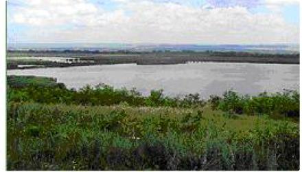
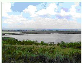
At Mața-Rădeanu, dykes were rebuilt to restore hydraulic control: a 1,800 m dyke separating Mața (Galați) from Cârja (Vaslui) and a 3,600 m dyke subdividing Mața; a birdwatching tower serves the complex. The area falls in SPA ROSPA0130 Mața-Cârja-Rădeanu and functions today as a large fish-farming/recreational fishing complex managed locally by AJVPS Galați; recent county risk documentation lists “Amenajarea Piscicolă Mața-Rădeanu.” In 2024, local press reported drought-related low water affecting this complex.
At Mața-Rădeanu, dykes were rebuilt to restore hydraulic control: a 1,800 m dyke separating Mața (Galați) from Cârja (Vaslui) and a 3,600 m dyke subdividing Mața; a birdwatching tower serves the complex. The area falls in SPA ROSPA0130 Mața-Cârja-Rădeanu and functions today as a large fish-farming/recreational fishing complex managed locally by AJVPS Galați; recent county risk documentation lists “Amenajarea Piscicolă Mața-Rădeanu.” In 2024, local press reported drought-related low water affecting this complex.
Position
Latitude
46.090833
Longitude
28.097778
Project
NWRM
National Id
Romania_ 06
Installation date
2009
Implementation Status
Contact
Bogdan Barbu, RECImola Koszta
RBD code
RO1000
Transboundary
0
Photo gallery
Location of the project
Within the Mața–Rădeanu fish-farming complex along the Prut dyke on the Galați–Vaslui border.
NUTS Code
RO22 - Sud-Est
Project's objectives
Improve the conservation status of 13 priority and 50+ other Birds Directive species present in the Lower Prut Floodplain Natural Park.
Re-establish the ecological balance of lakes by fixing degraded hydrological structures and improving/maintaining water levels.
Designate four SPAs (Romanian Natura 2000) and prepare/approve an integrated park management plan and administration.
Carry out inventories and monitoring, plus public engagement (village consultations, picture books, nature trails, six annual environment days, bird-watching towers).
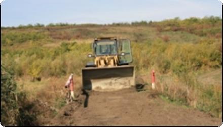
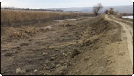
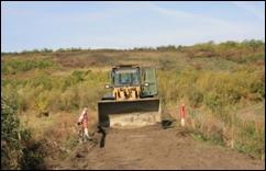
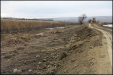
Rehabilitate dykes to manage water levels: 1,800 m boundary dyke (Mața–Cârja) and 3,600 m internal dyke subdividing Mața.
Re-establish the ecological balance of lakes by fixing degraded hydrological structures and improving/maintaining water levels.
Designate four SPAs (Romanian Natura 2000) and prepare/approve an integrated park management plan and administration.
Carry out inventories and monitoring, plus public engagement (village consultations, picture books, nature trails, six annual environment days, bird-watching towers).
Rehabilitate dykes to manage water levels: 1,800 m boundary dyke (Mața–Cârja) and 3,600 m internal dyke subdividing Mața.
Involved Partners
| Authority type | Authority name | Role | Comments |
|---|---|---|---|
Climate zone
warm temperate dry
Temperature
11
Precipitation
500
Elevation range
8
Groundwater level
~9–32 m depth; flow toward the Lower Prut floodplain
Vegetation class
Aquatic & palustrine vegetation.
Water bodies: Ecological Status
Good
Water bodies: Chemical Status
Good
Water quality status
Organic loading and high mineralization; risks from agricultural pesticides and transboundary accidental discharges
Project scale
Micro
Project scale specification
Site-level hydromorphology within a meso-scale park project.
Area subject to Land use change or Management/Practice change (ha)
605,400024414063
Wetlands belong to the category of ecologically fragile areas, their dynamic being influenced mainly by the qualitative and quantitative characteristic of the water in the hydrographical basin in which they extend. For this reason, the conservation measures promoted in these spaces must be doubled by a strict control of the anthropic activities / arrangements using water for different purposes or as a medium of discharging some wastes.
Total cost
€ 824,710
Financing authorities
Type of funding
EU-funds: LIFE+
Comments
412,355 €
Type of funding
National funds
Comments
412,355 € with all non-EU sources
Type of funding
Local funds
Comments
412,355 € with all non-EU sources
Compensations
0
Policy context
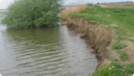
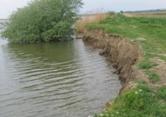
To deal with the degradation of hydrological structures, the project also aims to re-establish the ecological balance of the lakes, including improvement of the water level and its maintenance. The rehabilitation works are aimed at the maintaining of the water level of the Mata Lake for the protection of the existing habitats, an area making integral part of special conservation area in the Lower Prut Floodplain Natural Park, both during drought periods and the flooding ones.
Land ownership
State public domain (fish-farm area); operated by AJVPS Galați.
Community involvment
Yes
Design consultation activity
| Activity stage | Name | Key issues | Comments |
|---|---|---|---|
|
Implementation phase
|
Awareness raising activities
|
These include information dissemination, consultation of every village in the area, and active participation and education with local educational material to be produced. The project takes into account that there is a relatively high illiteracy in the area and will address stakeholders in wide variety of ways, including picture books, nature trails, six annual environment days with expeditions into the area, children's exhibitions, and bird watching towers
|
Policy target
| Target purpose |
|---|
|
Increase Water Storage
|
|
Improved Biodiversity
|
|
Groundwater Recharge
|
Policy pressure
| Pressure directive | Relevant pressure |
|---|
Policy impact
| Impact directive | Relevant impact |
|---|
Requirement directive
| Requirement directive | Specification |
|---|
Contractual arrangements
0
| Arrangement type | Responsibility | Role | Name | Comments |
|---|
Part of wider plan
1
Wider plan type
| Wider plan type | Wider plan focus | Name | Comments |
|---|---|---|---|
|
National
|
Environment & Biodiversity
|
Lower Danube Green Corridor programme
|
The management plan puts ongoing monitoring with the park administration, while the Mața–Rădeanu case lists Regional Environmental Protection Agency Galați and SOR specifically as monitoring actors.
As in the project framework, the site tracks bird population status and organochlorine pesticide bioaccumulation in birds, alongside water quality and quantity.
Maintenance
The restored dykes are maintained (filling/compacting gaps) to manage water levels across the 1,800 m boundary dyke and the 3,600 m subdividing dyke; the complex also has a birdwatch tower.
Better conditions for the birds population; increasing the number for aquatic bird species (especially those listed in Annex I of Birds Directive, Bern Convention and in ORNIS lists); improve the trophic state and saprobity of the target aquatic systems; allowing the water oxygenation of the lakes through the input of the fresh water from the Prut River; including the monitoring birds protocols in the adaptive Management Plan of Lower Prut Floodplain Natural Park;
Active fish-farming/recreational fishing platform (~607 ha, AJVPS), with generic tourism/recreation benefits from the restoration.
Active fish-farming/recreational fishing platform (~607 ha, AJVPS), with generic tourism/recreation benefits from the restoration.
Supply the potential of fisheries resources; using the potential of providing services for tourism and recreation;
Hydrological effects
Increased water storage and maintained levels
Water quality overall improvements
Positive impact-WQ improvement
Information on Water quality overall improvements
Improved trophic state and saprobity and oxygenation of the lakes by fresh Prut inflows
1
Restoration of aquatic birds sites in the natural protected area located in Lower Prut Floodplain Natural Park - Mata Lake
Key lessons
Rehabilitating key dykes (1,800 m boundary; 3,600 m internal) restored hydraulic control and helped keep water levels within a range that protects habitats during both low-water and flood periods; restoration here also contributes to broadening habitat networks relevant to Natura 2000.
Success factor(s)
| Success factor type | Success factor role | Comments | Order |
|---|---|---|---|
|
Attitude of decision makers
|
main factor
|
Clear technical leadership/roles (County Council initiation; design inputs from Park Admin, Forestry Dept., University; monitoring by REPA Galați and SOR). |
1
|
|
Financing possibilities
|
main factor
|
Financing mix: EU LIFE+, national, county. |
|
|
Communication activities
|
secondary factor
|
Park-wide communication and education measures that supported uptake. |
Driver
| Driver type | Driver role | Comments | Order |
|---|
Transferability
Highly transferable to low-gradient river–floodplain lakes: modest channel dredging plus small sluices and dyke repairs can restore levels and habitat. Success hinges on sediment load and long-term maintenance, available inflows, protected-area rules and stakeholder alignment. Watch for rapid re-siltation, drought-driven low flows and fish-farm constraints; embed monitoring of birds and water quality.
Source(s)
English