Last update
2025
Summary
More than half of the territory of the regional natural park of the Millevaches in Limousin (PNR) is covered with forest, some of which is the subject of intensive forestry exploitation. A peat bog restoration project in the headwater sector of the catchment area was initiated between the PNR (project manager) and the forestry cooperative Bourgogne Limousin (technical partner). The goal was to remove the softwood stand from the single-species plantation on the plot in order to restore the hydrological functioning of the peat bog. The work was carried out by aerial skidding using a cable mast. In addition to initiating collaboration between forestry and environmental management, the project has made it possible to restore the natural hydrological functioning of the bog and the associated specific habitats.
Position
Latitude
45.783575
Longitude
1.999168
Project
NWRM
National Id
France_08
Installation date
02.2015
Implementation Status
RBD code
FRG-La Loire, les cours d'eau côtiers vendéens et bretons
Transboundary
0
Photo gallery
Location of the project
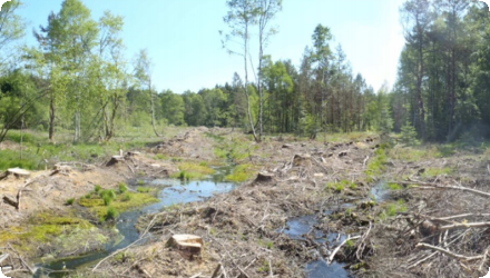
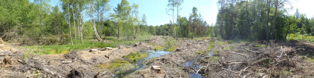
The Millevaches plateau is a medium altitude area located in the center of France. At the beginning of the last century, this territory consisted of large areas of moors and peat bogs on which extensive grazing was practiced. The Millevaches plateau is home to the headwaters of the catchment areas of many tributaries of the Vienne and Dordogne rivers. The project is located near Gentioux vilage and consists of a topographic peat bog crossed by two small rivers. In the 60s it has been recalibrated and drained and embankments created by the drainage action have been planted with softwood species. It is located in a Special Protection Area for birds. The recalibration of the river has created a deepening of the water tablme and incision of the embankment leading to drying of the peat bog further enhanced by softwood water consumption.
NUTS Code
FR63 - Limousin
Project's objectives
• Increase water retention by the bog to improve low-flow support.
• Increase sediment retention by the bog to improve the hydromorphology of the watercourse (la Vergne).
Others objectives from the project manager:
• Work in collaboration with the silvicultural community.
• Restore the environmental functionalities of heritage wetland habitats.
• Promote the avifauna targeted by the Millevaches plateau Special Protection Zone (SPZ) (including Short toed Eagle).
• Improve the landscape in the municipality.
• Promote the exemplarity of the approach.
Involved Partners
| Authority type | Authority name | Role | Comments |
|---|---|---|---|
Climate zone
cool temperate moist
Temperature
10.4 °C
Annual rainfall range
900 - 1200 mm
Elevation range
792 m
Vegetation class
The problematic vegetation that was felled consisted of large conifers. The remaining vegetation in the area is characteristic of peatland environments. Peat-bog vegetation with Sphagnum mats and purple moor-grass (Molinia caerulea); surrounding plantations of Sitka spruce and Scots pine (partly removed). Early post-works encroachment by birch and willow noted.
Water bodies: Ecological Status
Moderate
Water bodies: Chemical Status
Good
Water quality status
Downstream longitudinal fragmentation on the Maulde water body; locally, past drainage/recalibration and conifer planting caused incision and hydromorphological alteration of headwaters.
Project scale
Micro
Project scale specification
Single peat-bog site in a headwater micro-catchment, with localized logging and no heavy machinery in-situ.
Project area
1.5–1.8 ha
Area specifications
Inside a 5 hecatre peat-bog area.
Size
1.8
Size unit
ha
Restoration via tree removal (Sitka rows, part of pine/birch) to re-raise the water table and recover bog function.
Aerial skidding (cable-mast) to avoid soil/peat disturbance; no heavy machinery in the wetland.
Keep a few tall “perch” trees for raptors (ZPS objective).
Hydro & habitat outcomes assessed by annual CEN monitoring; IAM checks downstream.
No design storm/capture volume or hydraulic capacity is specified in sources.
The sensitivity of the environment made traditional logging unfeasible. The use of the emerging technique of aerial skidding allowed the operation to be carried out.
This NWRM was not chosen and deployed with a strict objective of action on the water cycle. The hydrological effects were a co-benefit for the project manager. The primary motivation of this project was to initiate a dynamic of work in collaboration with the forestry world.
Positive influence effectiveness
The low quality of the wood (due to the hydromorphic nature of the soil) made it easier to obtain the derogation from the simple forest management plan.
Total cost
€ 26,200
Costs operational
€ 26,400
Financing authorities
Type of funding
Other
Comments
€ 22,000 from the sale of the wood produced during the works.
Type of funding
Sub-national funds
Comments
(50% of remainder after wood sale)
€ 2,100
€ 2,100
Type of funding
Local funds
Comments
€ 1,260
Comments
€ 840
Policy context
After the war, at the same time as an agricultural decline, the territory was subjected to extensive afforestation accompanied by the drainage of planted peat bogs and the recalibration of certain streams. A limnogenic peat bog is located directly next to the village of Gentioux. It has been the subject of silvicultural activities since the 1960s and 1970s, when the two rivers in the area (the Vergne, a tributary of the Maulde, and its sub-tributary) were recalibrated and the plot was drained. Coniferous trees (Sitka spruces and Scots pines) were planted on the slopes resulting from the excavation of the drains. On the project site, the Vergne has been recalibrated and has an incision in its alluvial floor. The digging of drains has resulted in a lowering of the water table and dewatering of the peat bog and associated environments. Mono-specific softwood cultivation accentuates the hydromorphological alterations of the stream: up to 1.30 metres of incision in places. The root system of conifers promotes scouring of the banks and aggravates the lowering of the water table. Woody plants reduce efficient rainfall by increasing water pumping (strong evapotranspiration, the project manager referring to 50 m3 of water consumed per m3 of wood produced).
Land ownership
Privately owned by the Groupement forestier de la Brauze, managed by Philippe Jorrand.
Community involvment
No
Design consultation activity
| Activity stage | Name | Key issues | Comments |
|---|
Policy target
| Target purpose |
|---|
Policy pressure
| Pressure directive | Relevant pressure |
|---|
Policy impact
| Impact directive | Relevant impact |
|---|
Requirement directive
| Requirement directive | Specification |
|---|
Policy challenges requirements
Transferable to small, wet headwaters where conifers were planted/drained. Key cautions: fragile peat → avoid ground traffic; cost premium (≈20–30%) for cable-mast; align with Natura 2000 and forestry rules; anticipate low timber value; plan long-term monitoring.
Contractual arrangements
0
| Arrangement type | Responsibility | Role | Name | Comments |
|---|
Part of wider plan
1
Wider plan type
| Wider plan type | Wider plan focus | Name | Comments |
|---|---|---|---|
|
Regional
|
Water
|
Sources en Action
|
The “Sources en Action” Territorial Contract - a local environmental agreement aimed at protecting water sources and natural habitats.
|
Ecological monitoring and Monitoring of hydromorphology
Ecological monitoring consisting of vegetation surveys and faunistic observations was carried out by the Conservatory of natural spaces of Limousin in 2015, 2016 and 2017 at 12 stations. This monitoring was financed by the "Sources en Action" (Sources in Action) programme, within the framework of an agreement with the PNR.
Monitoring of hydromorphology (IAM protocol: morphodynamic attractiveness index) was carried out by the PNR in 2016 and 2019 immediately downstream of the bog, in order to monitor the evolution of the substrates of the river Vergne and to evaluate the effect of the restoration of the bog on fine sediments.
Monitoring of hydromorphology (IAM protocol: morphodynamic attractiveness index) was carried out by the PNR in 2016 and 2019 immediately downstream of the bog, in order to monitor the evolution of the substrates of the river Vergne and to evaluate the effect of the restoration of the bog on fine sediments.
• Ecological monitoring
• Monitoring of hydromorphology (IAM protocol: morphodynamic attractiveness index)
• Visual observations of the zone after the work
• Monitoring of hydromorphology (IAM protocol: morphodynamic attractiveness index)
• Visual observations of the zone after the work
Information on Increased groundwater level
A rise in the water table has been observed by the project manager immediately after the works, leading to its outcrop over the entire wetland. The lateral drains which were not blocked were all recolonized by sphagnum moss already in the first year (summer 2015), with the consequence of greatly slowing down the flows. The colonization of drains by sphagnum moss therefore contributed to raising the water level in the external fringes of the peat bog plot, which was former in the process of drying out.
Information on WFD ecological status obj quantity
Hydromorphologic monitoring shows a favorable evolution of granulometry: the initially silty-sandy substrate (2019) tends to be more heterogeneous and to evolve towards more gravel (trout spawning grounds).
1
The annual monitoring of the 12 stations highlighted:
• A strong regeneration of peaty habitats, and an expansion of sphagnum development over a large part of the plot in 2017.
• The appearance of 4 species of odonata, 5 species of orthopterans and one species of lepidoptera specific to peatlands.
• On some parts of the plot, a dynamic of closure (implantation of birch trees and willows) and drying (appearance of molinia turds).
• Due to the incision of the bed of the Vergne, the lack of hydrological reconnection of the associated wetlands with the watercourse.
Key lessons
The project was a success and allowed gathering forest managers and owners and the natural park. Despite the absence of piezometer to validate the water table rise, the fact the sphagnum recolonised the remaining drains, and a set of insects typical of wetlands have re appeared show the peat genesis restarted which is a positive conclusion. The low level of intervention on water flow and limitation of disturbance to the peat bog by using soft technique chosen by the natural park was validated by the success. The project allowed creating a specific programme on water and forests for the period 2017-2022, and inspired several other restoration projects using the same aerial skiddling method.
Success factor(s)
| Success factor type | Success factor role | Comments | Order |
|---|---|---|---|
|
Attitude of decision makers
|
main factor
|
<p>The low quality of the wood (due to the hydromorphic nature of the soil) and the environmental and regulatory constraints of the site made the forest manager consider the site of low interest both for timber harvesting and for planting new afforestation, and thus facilitated their involvement in the project. It also made it easier to obtain the derogation from the simple forest management plan. The financing of the work proved to be an obstacle, but the owner unblocked the situation by agreeing to transfer the wood to the PNR, which was able to generate revenue from the sale. In addition, the total cost of the project was relatively low, which helped convince the financial partners.</p>
<p> </p>
|
Driver
| Driver type | Driver role | Comments | Order |
|---|
English