Last update
2025
Summary
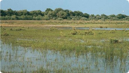
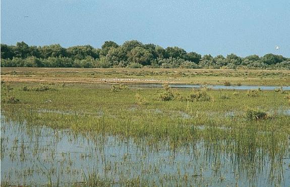
The Babina polder (~2,100 ha) was reconnected to the Danube in 1994, with recovery monitored by the Danube Delta National Institute. Within a few years, site-specific biodiversity redeveloped and ecosystem services such as nutrient retention and fish recruitment became evident; the reopened polder also supports reed harvesting, grazing, fishing and ecotourism.
Recent evidence shows how the system has evolved after three decades: remote-sensing analysis in the Matița–Merhei complex (including Babina Lake) detected a decline in open-water area between 2006 and 2018 (−13.4% at Babina) alongside expansion of aquatic vegetation, indicating sedimentation and succession.
In 2022, the reserve authority and DDNI implemented dredging of key links (Babina–Matița and Babina South–Ocolitor Pardina) to improve hydraulic connectivity.
Ongoing biological monitoring includes fish surveys that sampled Babina and Merhei lakes in 2016, underscoring the role of the restored complex for recruitment and fisheries.
Overall, Babina remains a flagship deltaic restoration now managed adaptively to sustain connectivity and habitat mosaics.
Position
Latitude
45.424722
Longitude
29.411667
Project
NWRM
National Id
Romania_02
Installation date
1994-05
Implementation Status
Contact
Imola Koszta, RECBogdan Barbu, REC
RBD code
RO1000
Transboundary
0
Photo gallery
Location of the project
Babina polder is in the Danube Delta Biosphere Reserve, within the Matița–Merhei aquatic complex, between the Chilia and Sulina branches.
NUTS Code
RO22 - Sud-Est
Project's objectives
Re-establish natural hydrology and connectivity of the former agricultural polder to the Danube by breaching the ring embankment at selected hydraulically effective points, in order to reflood the area and restore river-driven dynamics. In April 1994 the site was re-flooded via 4 breaches (two inlets, two outlets), each ~11–16 m² cross-section, to re-allow water circulation; works ran April–May 1994. Target area reconnecting to floods: ~2,100 ha.
Restore site-specific ecological functions (hydrological, biogeochemical and ecological) and the mosaic of habitats typical of the delta (reedbeds, shallow lakes, channels), as the prerequisite for biodiversity recovery.
Recover key ecosystem functions and services, explicitly expected to improve after reconnection:fish spawning/nursery habitat, waterbird breeding habitat, biodiversity reservoir, bioproduction, nutrient retention/turnover, and sediment & pollutant retention (i.e., “biological filter” function).
Enable sustainable traditional uses for local communities—fisheries, reed harvesting, grazing and ecotourism—once natural resources recovered.
Operate as a pilot/demonstration with planned monitoring, i.e., to document how fast characteristic habitats and functions would re-emerge and to guide adaptive management of restored areas.
Area reconnected ~2,100 ha; 4 breaches in the embankment (2 inlets, 2 outlets), ~11–16 m² each.
Involved Partners
| Authority type | Authority name | Role | Comments |
|---|---|---|---|
Climate zone
warm temperate moist
Temperature
11,5
Precipitation
375
Evapotranspiration
~950–1000
Elevation range
2
Slope range
0-1%
Vegetation class
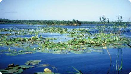
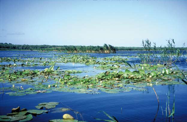
Predominantly reedbeds (Phragmites australis) and other emergent/floating aquatic vegetation; recent mapping documents the expansion of reed/aquatic vegetation in Babina.
Water bodies: Ecological Status
Good
Water bodies: Chemical Status
Good
Water quality status
2006–2018 decline of open water at Babina (~−13.4%) with expansion of aquatic vegetation, indicating sedimentation/succession; authors also note a general deterioration of lake water quality in recent years.
Project scale
Micro
Project scale specification
This is a single-site restoration of the ~2,100 ha Babina polder within the Danube Delta
Performance timescale
1 - 4 years
Project area
2100
Area subject to Land use change or Management/Practice change (ha)
2100
Lifespan
50
Design capacity description
n/a
n.a.
n.a.
Total cost
€2,407,000
Costs total information
n.a. info
Costs investment information
n.a. info
Financing authorities
Type of funding
Other
Comments
Delta Biodiversity Project, that includes the Babina site restoration
Type of funding
National funds
Compensations
0
Policy context
Reconnection of polder Babina, formerly destined
for agricultural purposes, to the flood regime
of the Danube.
for agricultural purposes, to the flood regime
of the Danube.
Community involvment
No
Design consultation activity
| Activity stage | Name | Key issues | Comments |
|---|
Policy target
| Target purpose |
|---|
|
Improved Biodiversity
|
|
Pollutants Removal
|
|
Runoff control
|
|
Oher Societal Benefits
|
|
Erosion Control
|
Policy pressure
| Pressure directive | Relevant pressure |
|---|
Policy impact
| Impact directive | Relevant impact |
|---|
Requirement directive
| Requirement directive | Specification |
|---|
Contractual arrangements
0
| Arrangement type | Responsibility | Role | Name | Comments |
|---|
Part of wider plan
1
Wider plan type
| Wider plan type | Wider plan focus | Name | Comments |
|---|---|---|---|
|
Environment & Biodiversity
|
Danube Delta Biodiversity Project
|
Management master plan for the Danube Delta Biosphere Reserve
|
Long-term monitoring of the restored polder led by the Danube Delta National Institute, with multi-year “success control” covering hydrology, morphology and biota; also environmental status at complex level (Matița–Merhei incl. Lake Babina).
Hydromorphological quality elements (hydrological regime and sediment transport); Biological quality elements (limnological studies conducted in consideration
of phyto- and zooplankton, macrozoobenthos,
phytophile fauna, fish and aquatic
vegetation etc); Physico-chemical quality elements (nutrient retention and transformation); socio-economic (evaluation of the grassland and its usability by the local population;
analysis with regard to a possible use of the agricultural potential for eco-tourism)
Maintenance
Hydraulic-connectivity maintenance by dredging of the short links that connect Babina to the lake network has been programmed/implemented by the Danube Delta Biosphere Reserve Authority (ARBDD)
Edge of Field/Plot
Field measurements; to monitor the area†™s filter function as for the solid matters suspended in the water, water samplings were taken. The limnological samples were taken within the frame of five field studies, together with the studies on terrestrial and aquatic macrophytes as well as
terrestrial and semi-aquatic macroinvertebrates.
The sampling sites of the studied area were determined
in a way to include all types of waters. Evaluation of reed areas available for sustainable use have been identified by means of remote sensing and on-site surveys. Spatial data of
the TM Mapper type have been used for the investigation
area.
After restoration, Babina generated >71.4 t yr⁻¹ of usable fish (~34 kg ha⁻¹ yr⁻¹) and created ~10 fishermen jobs (plus additional jobs in fish processing).
For the Babina + Cernovca pilot polders (36.8 km² combined), restored fisheries provide 20–25 jobs; diversified livelihoods include fishing, tourism, reed harvesting, and seasonal livestock grazing, earning on average ~€40 ha⁻¹ yr⁻¹.
Ecotourism: the renewed wetland landscape supports nature-based tourism, with Babina/Cernovca highlighted as having strong observation/recreation potential linked to nearby villages
Interesting aquatic landscapes for tourists thus may increase ecotourism in the area.
Information on retained water
Restored flood pulse + connectivity. After the 1994 breaches, DDNI measured flows at the inlets/outlets and tracked bed changes; lateral connectivity returned, but the flood regime differs from fully natural levee overtopping (water enters mainly via the new openings).
Sediment dynamics (needs maintenance). Inlet canals accumulated 0.60–2.17 m of alluvial deposits between 1996–2003 (main canal 0.80–1.50 m in 1994–2001); outlet sections showed 0.10–0.60 m of bed erosion. Authors flagged likely maintenance needs at inlets.
Sediment dynamics (needs maintenance). Inlet canals accumulated 0.60–2.17 m of alluvial deposits between 1996–2003 (main canal 0.80–1.50 m in 1994–2001); outlet sections showed 0.10–0.60 m of bed erosion. Authors flagged likely maintenance needs at inlets.
Ecosystem erosion control
1
Information on Ecosystem erosion control
At the opening level the sedimentation
of suspended solids formed a layer of 0.60-2.17
m height between 1996-2003. The erosion process is less intense. Solid matters resulting from erosion become sedimentation material for the next and longest part of the canal, where water velocity is low.
of suspended solids formed a layer of 0.60-2.17
m height between 1996-2003. The erosion process is less intense. Solid matters resulting from erosion become sedimentation material for the next and longest part of the canal, where water velocity is low.
Water quality overall improvements
Positive impact-WQ improvement
Information on Water quality overall improvements
Suspended solids “filter.” DDNI measured 95–115 mg/L TSS at the upstream opening vs 5–7 mg/L at the outlet after passage through reedbeds—evidence of strong clarification.
Nutrient retention. A field-based annual balance estimated ~702 t N yr⁻¹ retained (≈334 kg N ha⁻¹ yr⁻¹) and ~30 t P yr⁻¹ retained (≈14.5 kg P ha⁻¹ yr⁻¹). Later modelling estimated ~229 t N yr⁻¹ on Babina’s reedbeds (with Babina + Cernovca ≈ 356 t N yr⁻¹ across ~2,435 ha of reed).
Seasonal P behaviour (unexpected). Reedbeds act as a P sink in spring (sediment-bound P deposition), but can become a P source in summer (release of ortho-phosphate).
Oxygen & EC patterns (episodic stress). Channels often had 7–14 mg O₂ L⁻¹ at the surface (100–180 % saturation); temporary sunlit waters even > 200 % saturation, but deeper layers could be oxygen-poor. A summer 1999 eutrophication episode caused macrofauna mortality at one lake site. Conductivity ranged ~420–1210 µS cm⁻¹ across spots.
Information on Water quality Improvements (N)
229.4 tons of N/year (Total reduction N )
Soil quality overall soil improvements
N/A info
Information on Soil quality overall soil improvements
n.a. info
1
Rich and abundant zooplankton community that provides an excellent food source to fish. the fish fauna of Babina island found its own level with 29 species. The high diversity of macro- and microhabitats in the terrestrial and semi-aquatic area allow the reactivation of an extremely high biodiversity especially with regard to the arthropode fauna. The species spread along ecological gradients that cover a broad range between arid and moist. The reestablishment of site-characteristic habitats and food sources has also been to the benefit of both the European mink (Mustela lutreola) and the European otter (Lutra lutra).
Fish. Species richness rose from 2 species (autumn 1993) to 15 species (1995) soon after reconnection; fish spawning/nursery function re-established.
Birds. Avifauna diversity increased from 34 → 72 species in the early years post-restoration.
Macroinvertebrates & others. High densities of native molluscs near inlets (e.g., Lithoglyphus naticoides up to ~400 ind m⁻²); 43 spider species recorded (including 10 new for the Delta); Natura 2000 species noted (European mink, otter; Aldrovanda vesiculosa observed one season).
Longer-term trend (habitat mosaic shift). In Babina Lake, the free-water surface declined between 2006–2018 (e.g., from 81.67 % → 73.44 %, a loss of ~67.8 ha), with expansion of reed/floating vegetation—consistent with silting and succession (terrestrialisation).
Ecosystem impact climate regulation
No information available
Information on Ecosystem impact climate regulation
n.a. info
Key lessons
Re-establishing hydrological connectivity at a few, well-chosen breach points was the keystone. Even though floods inside the former polder no longer spread as broadly as under fully natural conditions, opening the dikes in hydraulically and ecologically effective spots quickly re-started near-natural processes and biodiversity recovery, and it set off a demonstration effect for further restorations in the Delta.
Long, multi-disciplinary monitoring proved essential. Over a decade, teams tracked water levels, flow velocities, canal cross-sections, nutrient retention, plankton, macrophytes, fish, birds, and mammals—evidence that guided management and underpinned claims of rapid ecological redevelopment.
Adaptive management is needed to keep connections open. Monitoring documented sediment deposition and cross-section changes in artificial canals; more recently, authorities scheduled dredging of key links (e.g., Babina–Matița; Babina-south to Ocolitor Pardina) as emergent and floating vegetation expanded and free-water percentages declined (at Babina, from ~82% in 2006 to ~73% in 2018).
Strong institutions and partnerships mattered. The World Bank/GEF project built DDBRA and DDNI capacity, and WWF’s collaboration helped pilot and scale works; lessons highlighted the need for early, professional public communication and participatory work with local communities.
Success factor(s)
| Success factor type | Success factor role | Comments | Order |
|---|---|---|---|
|
Other
|
main factor
|
Focused dyke breaching at hydraulically effective locations that rapidly re-activated flood dynamics and habitats. |
|
|
Conducted assessments (incl. economic)
|
main factor
|
Robust, long-term monitoring across hydrology, morphology and biota to steer management decisions. |
|
|
Successful coordination between authorities
|
main factor
|
Institutional capacity and continuity (DDBRA/DDNI) strengthened by GEF/World Bank support and WWF partnership. |
|
|
Other
|
secondary factor
|
Demonstration value that catalyzed further reconnections elsewhere in the Delta (e.g., Cernovca) and fed into basin programs. |
|
|
Conducted assessments (incl. economic)
|
secondary factor
|
Documented ecosystem-service returns (fish, reed, nutrient retention; tourism) that built local buy-in. |
Driver
| Driver type | Driver role | Comments | Order |
|---|---|---|---|
|
Balancing different objectives
|
main driver
|
Ecological reconstruction/restoration to restore the natural, site-specific hydrological, biogeochemical and ecological functions, to ensure the redevelopment of the ecosystem and its functions and thus to promote the development of site-specific habitats and their biodiversity. Moreover, the redevelopment of the natural resources should enable the local populations to proceed to their sustainable, traditional use.
|
1
|
Transferability
Transferable to embanked floodplains/polders where selective levee breaches can re-establish flood pulses. Key needs: careful siting of openings, long-term monitoring, and adaptive maintenance to counter siltation/terrestrialisation. Check ownership, permits and local uses early. Watch for constrained inundation patterns and seasonal phosphorus release; design for sustained connectivity, not a one-off dig.
English