Between 2016 and 2021, two implementation phases were completed, with over €7 million invested. Monitoring reports documented positive impacts on flood mitigation, biodiversity, and hydromorphological processes. A third phase is planned under Spain’s 2022–2030 National River Restoration Strategy, with an additional €3 million allocated.
The project is recognised as a model for large-scale river reconnection in agricultural landscapes. Follow-up studies assess vegetation recovery (active vs passive restoration), aquatic fauna return, and groundwater recharge. Coordination involves the Government of Navarra, Confederación Hidrográfica del Ebro, Fundación Biodiversidad, and WWF Spain.
100 ha of restored floodplain
7 km of river restored or reconnected
4 oxbow lakes and several side channels re-created
12 municipalities involved in land negotiations
Improve riparian and aquatic habitats
Enhance biodiversity, with a focus on endangered species, especially the European mink (Mustela lutreola), a flagship species of the LIFE+ project.
Control the spread of the invasive American mink
Contribute to natural flood risk reduction
Revert land use in the floodplain : Convert intensive agricultural or poplar plantation areas into semi-natural riparian habitats, Promote sustainable land use compatible with periodic flooding
Raise awareness and engage local stakeholders
| Authority type | Authority name | Role | Comments |
|---|---|---|---|
Populus nigra (black poplar)
Salix spp. (willows)
Ulmus minor (field elm)
Fraxinus angustifolia (narrow-leafed ash)
Alnus glutinosa (alder)
Wetland and floodplain herbaceous vegetation, particularly in reconnected oxbows and meanders.
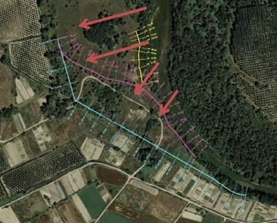
Set back a total of 2,620 linear metres of earth embankments which will allow water to spread naturally during flood events and to recover the natural habitats over 29 hectares of floodplain.
Remove a total of 660 linear metres of earth embankments, which will allow recuperation of 3.9 ha.
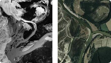
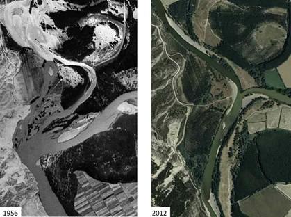
Recover and restore the fluvial space of the meander “el Platnío” of River Arga of 24 ha.
Construct at least three wetlands, suitable for use by the European mink and with a total surface area of 7.6 ha. -Restore habitats in at least 17 action areas, accounting for a total of 230 hectares of restored natural habitats
Conserving functions, interactions, dynamics, continuity and connectivity of fluvial ecosystems.
Contributing to reducing peak flood flows, minimizing flooding levels, which benefits the population centres downstream.
Solving spatial development challenges in flooding areas, thus contributing to reducing exposure to risk, which means in the short term potentially major savings in defences and compensations.
Improving and consolidating the fluvial landscape, and returning to a more natural state.
Building the essential basis, both functional and territorial, for the conservation of fluvial spaces and restoration.
Fostering public interest and awareness.
Progressively integrating cost-benefit analysis in the decision-making process about the river system management.
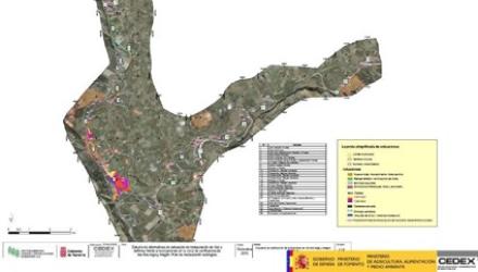
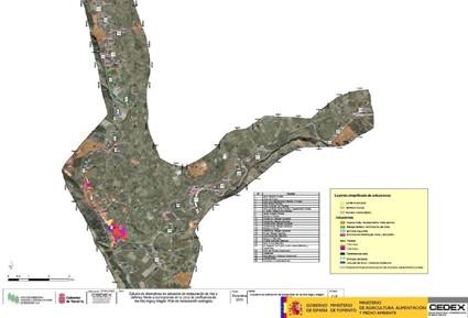
Some projects required a topographical survey and water modelling to provide information on the land floodability.
Work started removing the ripraps and restoring the habitat. Particular care was taken to use native plant species and varieties.
Involvement of CRANA (Navarre’s Environmental Resource Centre) as an administrative unit capable of achieving public participation and stakeholder engagement in the whole process.
Farmers’ commitment since they are the primarily affected agents by flooding events.
- Natural and physical conditions allow N5, N4 and N8 to be carried out in the months of August and September, taking advantage of the low river flow during those months. Also N2, N3 and F1 can be easily carried out during those months when there is no plant growth (from November to February), in order to guarantee the plantation success.
- The fact that most of the compromised lands are publicly owned facilitates the negotiation with landowners to acquire the plots and make possible the restoration activities.
- Since the selected case-study site comprise not very productive lands (most of them poplar plantations) make cheaper the compensation required for the loss of profits derived from giving up the activities developed in the floodplains to be restored.
- The relatively high GDP per capita (29,071 in euros) of the area inhabitants and the fact that The Navarre Regional Government has its own financing capacity influence positively in the development of the planned intervention activities. (Source: Anuario Estadístico, Instituto de Estadística de Navarra, (2012))
- The existence of a large riverside dimension and the large floodplains allows and facilitate the recovery of the river natural space.
Phase I : 6.023.406 + 257.412,07 + 138.840,25 € : the project Life+ Mink territory + total cost phase I and II for the project INTERREG IIIa GIRE-IMER restoring the "El Plantío"meander + total cost for the Life project GERVE restoration of the "Barranco Vallacuera"
Agreements with local councils (or other local authorities) for the lease of the rights to use this common-property land, which had already been identified as potentially suitable for the restoration of habitats. The agreements put forward consist of paying the council for the loss of income derived from felling the poplar plantations located on land intended for restoring natural copses or wetlands for the mink. It was also proposed to pay the councils for the loss of income derived from carrying out restoration schemes on farming land that has the potentiality for conversion into copses.
Stability does not exist in these sections, major flooding events occured in February 2003 (Arga Q=930.2 m3/s T=15), in April 2007 (Arga Q=910 m3/s T= 10 Aragón Q= 1394 m3/s T=25) and in January 2010 (Aragón, Q= 806 m3/s Arga, Q= 730 m3/s T= 3-4).
The restoration of the floodplains and the natural habitats, will permit the coordinated application of the three European river management related Directives: the Habitats Directive (1992/43); the Water Framework Directive(2000/60); and the Flood Prevention Directive (2007/60). This also goes in line with the EU Biodiversity Strategy to 2020 (COM (2011) 244) seeking to address the protection and restoration of biodiversity and associated ecosystem services.
| Activity stage | Name | Key issues | Comments |
|---|
| Target purpose |
|---|
|
Peak-flow reduction
|
|
Improved Biodiversity
|
|
Increase Water Storage
|
|
Oher Societal Benefits
|
Flood control and risk mitigation by restoring floodplains, so that they can perform its main function, driving away the energy of floodwaters by storing them during the flood process.
| Pressure directive | Relevant pressure |
|---|---|
|
WFD identified pressure
|
4.1.1 Physical alteration of channel/bed/riparian area/shore of water body for flood protection
|
|
WFD identified pressure
|
4.1.2 Physical alteration of channel/bed/riparian area/shore of water body for agriculture
|
|
Floods Directive identified pressure
|
Defence or Infrastructural Failure
|
|
Other EU
|
Habitats Directive (1992/43): Modification of hydrographic functioning, general (J02.05) and flooding modification (J02.04)
|
| Impact directive | Relevant impact |
|---|---|
|
WFD identified impact
|
Altered habitats due to hydrological changes
|
|
WFD identified impact
|
Altered habitats due to morphological changes
|
|
Floods Directive identified impact
|
Protected areas
|
|
Other EU
|
Habitats Directive (1992/43) Inundation (natural processes) (L08)
|
Additionally, in the case of the Habitats Directive the impact of the measures directly seeks to enhance the habitat conservation status, which is also in line with the EU Biodiversity Strategy to 2020 (COM (2011) 244) seeking to address the protection and restoration of biodiversity and associated ecosystem services.
| Requirement directive | Specification |
|---|---|
|
WFD-achievement of good ecological status
|
|
|
Floods Directive-mitigating Flood Risk
|
|
|
The Birds and Habitat Directives
|
According to the FD, flood risk management plans should focus on giving rivers more space and should consider the maintenance and/or restoration of floodplains, since they contribute to reducing peak flows by flooding, and minimizing flooding levels which significant benefits in urban areas downstream.
The comprised area is one of the Sites of Community Importance (SCI) included in the Natura 2000 network. The area’s importance is mainly due to the presence of Mediterranean river forest habitats (Mediterranean poplar and willow forests) and species such as European mink (Mustela lutreola), otter (Lutra lutra), European turtle (Emys orbicularis) and night heron
(Nycticorax nycticorax).
Additionally, some requirements from the EU Biodiversity Strategy to 2020 (maintaining and restoring ecosystems and their services and enhancing efforts to protect species and habitats) are also addressed by these measures.
| Arrangement type | Responsibility | Role | Name | Comments |
|---|
| Wider plan type | Wider plan focus | Name | Comments |
|---|---|---|---|
|
Catchment-based
|
Environment & Biodiversity
|
Natura 2000 Network - SIC: ES2200035 / lower reaches of the Arga and Aragón rivers
|
|
|
Catchment-based
|
Water
|
National Plan of Rivers restauration / Hydrological connection of the lower reaches of the Arga and Aragón Rivers
|
|
|
Project-based
|
Water
|
INTERREG IIIa - GIRE "Integrated Management of European Rivers"
|
|
|
Project-based
|
Environment & Biodiversity
|
Life project "GERVE - Ecosystemic Management of Rivers with European Mink"
|
Habitat and biodiversity conservation (recovering and increasing the European mink population)
Clear water (achieving the good ecological status (GES) according to the WFD).
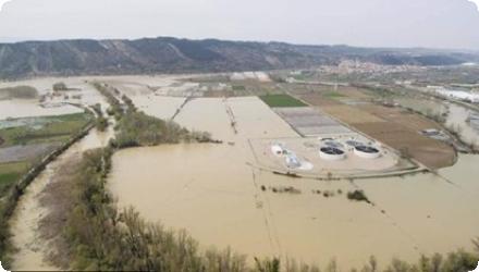
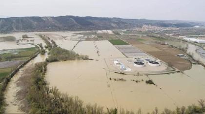
Data from the 2003 flooding in Navarra indicate that the economic losses, including production losses and infrastructure damages, where estimated in more than 9 millions euros. In the case of the flooding event in 2007 the total amount of damages in public and private infrastructure and agricultural production losses were quantified in more than 8 millons euros. (Source: Gobierno de Navarra (2010)).
Local socio- economic benefits when developing the measures in terms of employment and local consumption
The provision of clear water in turn yields social benefits as recreational services and amenity (increased demand for recreation or increased number of visitors) and clean drinking water
Habitat and biodiversity conservation perform numerous ecosystem functions that provide multiple co-benefits as in the case of storing and fixing carbon, serving as wildlife habitats and ecological corridors, stabilizing stream banks, providing shade, organic matter, retaining sediments and filtering chemicals applied on agricultural sites on upslope regions.
The afforestation of riparian areas and the restoration of the wetlands are also of strategic importance to other species and also for aquatic birds present in the area.
Despite land-use pressures, over 100 hectares of disconnected floodplain were restored.
Success required strong collaboration with 12 municipalities and compensation or reclassification of land use (e.g. replacing poplar plantations).
2. Public land ownership facilitates restoration
The majority of the land was publicly owned, enabling easier access, implementation, and long-term commitment to ecological restoration.
3. Combining active and passive restoration can be effective
Areas were either actively replanted with native species or left to regenerate naturally.
Monitoring showed both strategies contributed to biodiversity and habitat recovery.
4. Hydrological restoration reduces flood risks and improves water retention
After project implementation, real flood events demonstrated lower damage in adjacent urban areas (e.g. Funes), validating the hydraulic benefits of natural retention.
5. Targeting biodiversity (e.g. European mink) can increase ecological ambition
Using an endangered flagship species helped mobilise political and public support and ensured high ecological standards across interventions.
6. Strong institutional coordination is key
Success depended on collaboration between local (Navarra Government), basin-wide (Confederación Hidrográfica del Ebro), national (MITECO), and European (LIFE+) actors.
7. Restoration fits within broader adaptation and climate strategies
The project is now cited as an example in Spain’s National River Restoration Strategy (ENRR 2022–2030) and climate adaptation tools like AdapteCCa, highlighting its value beyond biodiversity.
| Success factor type | Success factor role | Comments | Order |
|---|---|---|---|
|
Public participation
|
main factor
|
The low population density (60 inhabitants/km2 on average), the small and compact urban centres and the fact that buildings are fairly concentrated paved the way for the required interventions. |
|
|
main factor
|
The fact that most of the compromised lands were publicly owned facilitated the bargaining process with landowners to acquire the plots and make the restoration activities possible. |
||
|
Financing possibilities
|
secondary factor
|
Since the selected case-study site comprises not very productive lands (most of them poplar plantations) this made less costly the compensation required for the loss of profits derived from giving up the activities developed in the floodplains to be restored. |
|
|
Financing possibilities
|
main factor
|
The availability of different funding mechanisms and match-funding schemes; LIFE+, LIFE-GERVE, INTERREG IIIAa GIRE-IMER |
|
|
Legal obligations
|
secondary factor
|
Since the area is considered of high ecological value (included in the SCI) this made easier the active engagement of stakeholders and the funding availability for the development of restoration interventions. |
|
|
Financing possibilities
|
secondary factor
|
The relatively high GDP per capita (29,071 in euros) of the area and the fact that the Navarre Regional Government has its own financing facilities positively influenced in the development of the planned intervention activities. |
|
|
Other
|
main factor
|
The existence of a large riparian area and the large floodplains allowed and facilitated the recovery of the river’s natural space. |
| Driver type | Driver role | Comments | Order |
|---|---|---|---|
|
Balancing different objectives
|
main driver
|
The lower reaches of the Aragón and Arga rivers forms one of the Sites of Community Importance (SCI) included in the Natura 2000 network. The project area hosts a fifth of the species population in Navarra and two-thirds of the Iberian population; hence the importance of restoring the river ecosystems of the lower reaches of these two rivers for the global strategy of the species conservation.
|
1
|
|
Past flooding events
|
main driver
|
Give solution to the endemic flood challenges of the river system - shift from traditional paradigms
|
2
|
Population density and the existing on site.
The compensation scheme to offset landowners’ income losses and land productivity; in case that land productivity or the financial compensation is too high it may yield very large costs