Last update
2025
Summary
Órbigo River (Duero Basin, NW Spain) ecological status improvement. A bundle of sponge measures - levee removal/set-back, rip-rap removal, recovery of secondary channels, floodplain reconnection, natural bank stabilisation, and riparian buffer restoration - was implemented under the WFD and Floods Directive; the project was a 2013 IRF European Riverprize finalist.
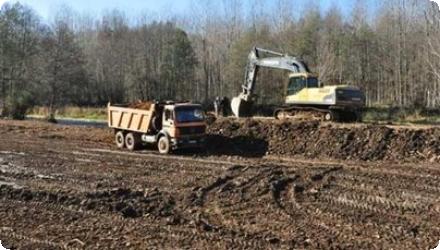
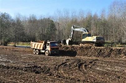
Section I (upper ~23.5 km) was built in 2011–2013: ≈4.72 km of rip-rap and 8.71 km of levees were removed, 3.13 km set back, ~10 km of side channels reopened, and ~300 ha of floodplain reconnected; limited works followed in Sections II–III. The Alcoba weir was modified by cutting a central notch (~15–16 m) with seasonal removable boards and a ramp to restore fish passage and sediment/nutrient continuity, reconnecting ~25 km of river.
Post-project assessments report increased channel dynamism and sinuosity and riparian vegetation regeneration - moderate effectiveness in the short term, underscoring the need for long-term monitoring. Overall, actions improved lateral and longitudinal connectivity and enhanced natural flood attenuation; AdapteCCa summarises ~480 ha of floodplain now functioning with the river.
Position
Latitude
42.65652004
Longitude
-5.82061595
Project
NWRM
National Id
Spain_02
Installation date
2012
Implementation Status
Contact
Gonzalo Delacámara and Marta Rodríguez (IMDEA Water) in close cooperation with Ignacio Rodríguez Muñoz, José Ignacio Santillán Ibáñez and Rosa Huertas (Duero River Basin Authority, Confederación Hidrográfica del Duero)
RBD code
ES020
Transboundary
0
Photo gallery
Location of the project
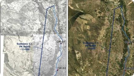
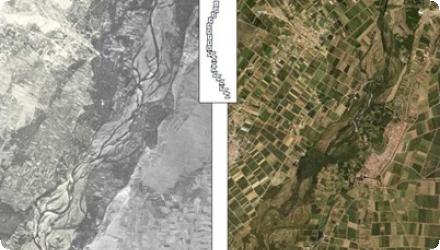
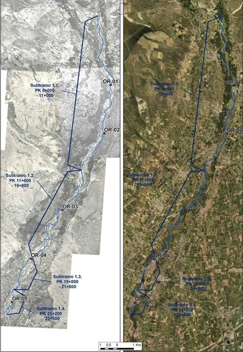
This application has been implemented in a 23.5 km long stretch (stretch I) of the Órbigo River (Duero River Basin) located in the northwest of Spain.
NUTS Code
ES41 - Castilla y León
Project's objectives
Project-wide aims (108 km): restore lateral connectivity (remove/set back levees/riprap, reopen floodplain/secondary channels), improve longitudinal connectivity (permeabilize weirs, notably Alcoba), and restore riparian buffers and dynamics, integrating WFD and Floods Directive goals.
Involved Partners
| Authority type | Authority name | Role | Comments |
|---|---|---|---|
Climate zone
warm temperate dry
Temperature
10,7
Precipitation
535
Annual rainfall range
300 - 600 mm
Elevation range
900 m
Slope range
0-1% (average slope of the Órbigo River Stretch I: 0.3%)
Vegetation class
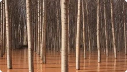
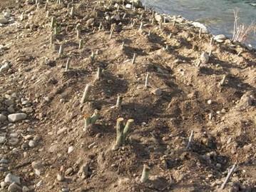
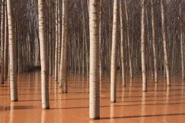
Riparian vegetation with poorly preserved continuity due to replacement with other uses (adjacent crops: agro (irrigation) and forest (poplar: Populus x euroamericana).
Water bodies: Ecological Status
Good
Water bodies: Chemical Status
Good
Water quality status
All good : Oxygen: 9.79 mg/l, pH: 7.71, Ammonium: 0.05 mg/l, BOD5: 2.00 mg/l, Nitrate: 1.12 mg/l, Diatom index: EQR IPS 2007: 1.17 , Macroinvertebrates EQR IBMWP: 1.53.
Project scale
Meso
Project scale specification
Length of the stretch to be improved by means of this specific project: 23.5 km. Area: around 45 ha.
In the near future (already passed environmental and technical assessment and pending to obtain funding) similar projects will be carried out in downstream stretches (segment II: 27.5 km; and segment III: 57.8 km)
In the near future (already passed environmental and technical assessment and pending to obtain funding) similar projects will be carried out in downstream stretches (segment II: 27.5 km; and segment III: 57.8 km)
Performance timescale
1 - 4 years
Project area
160500
Area subject to Land use change or Management/Practice change (ha)
45
Size
45
Size unit
ha
Lifespan
Specific values for certain elements are commonly used. Examples: 50 years for civil works, 25 years for electromechanical compounds, 0 years for alive vegetation
Design capacity description
Variable volume of retained water according to circulating water flow. For this kind of intervention it is more appropriate to use the concept of "slow down flow water"; and the use of simulation models (different water volumes and return periods). e.g. Flood lamination: 4-5 hm3; Water volume: 590 m3/s; Return period: 500 years [Source: River Basin Authority, personal communication]
Positive influence effectiveness
Compatible land uses (irrigated poplar plantation instead of human settlements) in the majority of the floodplain areas. The flow is permanent regime (during dry years fluvial ecosystem is not under stress). Good water quality.
Negative influence effectiveness
The river can be easily and rapidly destabilized due to bank stability destabilization or changes in flow/sediment regime. 23% of the river stretch length contains regulating infrastructures.
Total cost
3084697,25
Costs total information
This is the total projected budget. Budget breakdown: 1. Lateral connectivity and dynamics improvement works (52.01%); 2. Longitudinal continuity improvement works (15.70%); 3. Riverbank estabilization works (7.52%); 4. Site access improvement (11.14%); 4. Supplementary works (2.57%); 5. Other items: monitoring of works (3.89%); environmental monitoring (3.89%); risk prevention (2.23%); waste management (1.06%)
Executed budget: 2065264.81 €
Executed budget: 2065264.81 €
Costs land acquisition information
Null value as intervention were carried out in Public domain land
Costs operational information
Commonly no operational cost is associated to this kind of project (river restoration) [Source: García et al. (2013)]
Costs maintenance information
Variable according to the specific element considered (average values for Spanish river basins: 1.2% of initial investment cost for fishladders; 20% of total investment cost for revegetation works; 15% of total investment cost for bioengineering works). Due to the implementation of the project maintenance costs have been drastically reduced. These costs were expected to be very low and assumed by the Duero River Basin Authority within the framework of its Public Domain Conservation Programme
Financing authorities
Type of funding
National funds
Comments
This measure is implemented within the framework of the National Strategy for River Restoration (ENRR, Estrategia Nacional de Restauración de Ríos).
Compensations
0
Policy context
The municipalities of Cimanes del Tejar, Llamas de la Ribera, Carrizo de la Ribera, Turcia and Santa Marina del Rey located by the Órbigo River (León province, Castilla y León Region) were suffering from the effects of hydromorphological (weirs, channels…) and land-use patterns change pressures for this water body: loss of lateral (main derived problem: floods) and transversal connectivity, river dynamics (derived problems: erosion and sedimentation) alteration, flow alteration and riparian forest loss and fragmentation.
Land ownership
Public land.
Community involvment
Yes
Design consultation activity
| Activity stage | Name | Key issues | Comments |
|---|---|---|---|
|
Screening phase
|
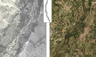
Preparatory phase (year 2009): with municipal majors/neighbourhood associations'representatives. Using ortophotos (years 56-57, 2004 and 2008) as a basis for analysing changes in floodplain
|
||
|
Design phase
|
a) Diagnosis phase (year 2009): Compilling and analysing information provided by the referred stakeholders; b) Informative sessions: with other interested stakeholders (inhabitants)
|
||
|
Other
|
Public hearing phase (year 2009: alternatives were discussed and showed by means of computer simulation on the basis of ortophotos (years 2004 and 2008).
|
[CHD, 2013b]: More than 50 meetings (in a period of 3 years) with stakeholders.
|
|
|
Other
|
Monitoring
|
[Source: Barquero and Santillán (2012a)]
|
|
|
Design phase
|
Informative sessions (for stakeholder (inhabitants)
|
||
|
Implementation phase
|
a) Informative sessions (for stakeholder (inhabitants); b) Dissemination activities (for external audience) and field trips: Riverbasin Authority/Ministry of Environnment Websites; Specialised national/international networks on river restoration (newsletters, presentations). 2013 IRF European Riverprize finalist practice.Field trips from: Universities, Administration bodies, within in the framework of specialised workshop; c) Newspapers; d) Volunteering and environmental education programme
|
||
|
Screening phase
|
CONSULTATION ACTIVITIES
|
Preparatory phase (year 2009): with municipal majors/neighbourhood associations'representatives. Using ortophotos (years 56-57, 2004 and 2008) as a basis for analysing changes in floodplain
|
|
|
Design phase
|
CONSULTATION ACTIVITIES
|
a) Diagnosis phase (year 2009): Compilling and analysing information provided by the referred stakeholders; b) Informative sessions: with other interested stakeholders (inhabitants)
|
|
|
Other
|
CONSULTATION ACTIVITIES
|
Public hearing phase (year 2009: alternatives were discussed and showed by means of computer simulation on the basis of ortophotos (years 2004 and 2008).
|
[CHD, 2013b]: More than 50 meetings (in a period of 3 years) with stakeholders.
|
|
Other
|
CONSULTATION ACTIVITIES
|
Monitoring
|
[Source: Barquero and Santillán (2012a)]
|
|
Design phase
|
COMMUNICATION
|
Informative sessions (for stakeholder (inhabitants)
|
|
|
Implementation phase
|
COMMUNICATION
|
a) Informative sessions (for stakeholder (inhabitants); b) Dissemination activities (for external audience) and field trips: Riverbasin Authority/Ministry of Environnment Websites; Specialised national/international networks on river restoration (newsletters, presentations). 2013 IRF European Riverprize finalist practice.Field trips from: Universities, Administration bodies, within in the framework of specialised workshop; c) Newspapers; d) Volunteering and environmental education programme
|
Policy target
| Target purpose |
|---|
|
Peak-flow reduction
|
|
Runoff control
|
|
Erosion Control
|
|
Improved Biodiversity
|
|
Oher Societal Benefits
|
Target Remarks
Flood control and flood risk mitigation. As a final aim. Recovering morphology and hydraulic capacity of the former stream bed of the river and its connectivity with the floodplain and improving longitudinal continuity (by means of works to 1) improve lateral connectivity and dynamics; 2) improve longitudinal continuity; 3) forest actions (revegetation)
Mass stabilisation and control of erosion rates.
Biodiversity and gene-pool conservation in riparia. More accurately: improve ecological status of the river.
Mass stabilisation and control of erosion rates.
Biodiversity and gene-pool conservation in riparia. More accurately: improve ecological status of the river.
Policy pressure
| Pressure directive | Relevant pressure |
|---|---|
|
Floods Directive identified pressure
|
Natural Exceedence
|
|
Floods Directive identified pressure
|
Blockage / Restriction
|
|
WFD identified pressure
|
4.1.1. Physical alteration of channel/bed/riparian area/shore of water body for flood protection
|
|
WFD identified pressure
|
4.2.2. Dams, barriers and locks for flood protection
|
Pressures remarks
Loss of lateral (main derived problem: floods) and transversal connectivity, river dynamics (erosion and sedimentation) alteration, flow alteration and riparian forest loss and fragmentation. Pressures for this water body (identified by IMPRESS): hydromorphological (weirs, channels...) and land-use patterns.
Policy impact
| Impact directive | Relevant impact |
|---|---|
|
Floods Directive identified impact
|
Waterbody status (adverse permanent or long-term consequences ecological or chemical status of surface water bodies or chemical status of ground water bodies affected, as of concern under the WFD due to the hydromorphological impacts of flooding)
|
|
Floods Directive identified impact
|
Infrastructure (adverse consequences to infrastructural assets such as utilities, power generation, transport, storage and communication)
|
|
Floods Directive identified impact
|
Other environmental impacts: other potential permanent or long-term adverse environmental impacts, such as those on soil, biodiversity, flora and fauna, etc.
|
|
WFD identified impact
|
Altered habitats due to morphological changes
|
|
WFD identified impact
|
Altered habitats due to hydrological changes
|
Requirement directive
| Requirement directive | Specification |
|---|---|
|
Floods Directive-mitigating Flood Risk
|
By means of measures aimed at giving river more space
|
|
WFD-achievement of good ecological status
|
By means of measures aimed at improving the hydromorphological conditions of the water body (river continuity and morphological conditions, mainly)
|
Policy challenges requirements
National Strategy for River Restoration (Estrategia Nacional de Restauración de Río, ENRR), Sub-programme 3 (improvement of the longitudinal continuity of the rivers within the Duero basin) and 4 (improvement of the lateral continuity of the rivers within the Duero basin)
Contractual arrangements
0
| Arrangement type | Responsibility | Role | Name | Comments |
|---|
Part of wider plan
1
Wider plan type
| Wider plan type | Wider plan focus | Name | Comments |
|---|---|---|---|
|
National
|
Water
|
National Strategy for River Restoration (Estrategia Nacional de Restauración de Río, ENRR)
|
Sub-programme 3 (improvement of the longitudinal continuity of the rivers within the Duero basin) and
4 (improvement of the lateral continuity of the rivers within the Duero basin) [Source: Rodríguez et al., 2012a] |
This works are assumed by the Duero River Basin Authority
So far: areas suffering from intense erosion and deposition processes; side arms dynamics according to variable water flow levels; wet areas after intense flood events (April 2013 and 2014) and perception of local population towards changes. Planned new activities to be carried out during 2014: topographic characterization of the most active areas.
Maintenance
Channel : natural and dumped debris regular removal; removal of excessice or dead vegetation, sediment removal. Shoreline regular inspection and replacement of damaged vegetation when required. Fish ladders: inspection and structure repair/rehabilitation.
Catchment outlet
Field visits, drone images (comparison before and after floods), information from stakeholders.
Flood protection (material damage reduction)
Recognition as climate adaptation good practice
Recognition as climate adaptation good practice
Information on retained water
Variable volume of retained water according to circulating water flow and water depth. For this kind of intervention it is more appropriate to use the concept of "slow down flow water" and the use of simulation models (different water volumes and return periods). E.g. Flood lamination: 4-5 hm3; Water volume: 590 m3/s; Return period: 500 years
Information on Peak flow rate reduction
According to the Planning Office (River Basin Authority) (on-going evaluation) NRWM have performed properly against floods that took place during Winter 2013 (160 m3 flood: same as those in 1995 and 2000 causing serious damage) and during the Winter of 2014 (300 m3). These were successfully abated thanks to NWRM [Source: River Basin Authority, personal communication]
Information on Increased infiltration
Greater infiltration rate and rate of recharge of the natural floodplains.
Information on Restoring hydraulic connections
Restored transversal and longitudinal connectivity, reopening ~10 km of side channels, and recovery of 300–480 ha of floodplain enhancing natural flood attenuation capacity. The Alcoba modification enables fish migration and sediment/nutrient continuity during non-irrigation seasons (boards removed), reconnecting ~25 km.
Ecosystem flood control volume
160
Information on Ecosystem flood control volume
According to Planning Office (River Basin Authority) (on going evaluation) these NRWM have performed properly against floods that took place during Winter 2013: 160 m3 flood, (same that in 1995 and 2000 caused serious damage) was successfully abated thanks to implemented NWRMs
Ecosystem erosion control
1
Water quality overall improvements
Not relevant for this application
Information on Water quality overall improvements
According to technical project, initial water quality status for the Stretch I (chemical/physical status /microinvertebrates/diatomes) was rated as good-very good so no specific measures were designed for this purpose. Despite of this, first evaluation results show that the ecological status of this water body has been improved.
Soil quality overall soil improvements
N/A info
Information on Soil quality overall soil improvements
Positive effects regarding infiltration rate and rate of recharge of the alluvial natural floodplains and soil fertilization are expected but no empirical evidence has been obtained yet [Source: CHD (2013b]]
Information on Soil quality overall soil carbon
Positive impact-SQ improvement
1
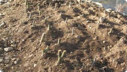
After dismantling levees and revetments along a ~21.6 km segment, the Órbigo showed channel widening and regeneration of riparian vegetation towards more natural willow/poplar communities, evidencing increased dynamism
Ecosystem impact climate regulation
No information available
Ecosystem provisioning services
1
Information on Ecosystem provisioning services
Recreational (opening access to the river banks); b) Integration of the river in urban areas (improvement of the landscape and tourism sector strenthening)
Key lessons
A 2013 IRF European Riverprize finalist.
a) Good practice of integrated water management and land use policies
b) Implementation of innovative concepts (e.g. “room for the river”, green infrastructure…)
c) Relevance of management and planning tasks.
d) Example of integrated approach in WFD and FD implementation
e) Example of the need to devote a great deal of time and effort to explain to the stakeholders the scope of the measures in order to achieve their acceptance and their participation. Multiplier effects are obtained when stakeholders became aware of the effectiveness of the measures.
e) Example of the relevance of public involvement during the whole process (public participation during the planning cycle and volunteering within the framework of environmental programme linked to the Project).
f) Impact on the media (beyond the pressnotes on the plan).
g) Replicability (downstream stretches) potential and networking potential (the project derived in the participation of the Basin Authority -together with other 4 European basin authorities- in the ECRR Community of Practice -launched in 2013 as a network for sharing their experiences in river restoration).
Success factor(s)
| Success factor type | Success factor role | Comments | Order |
|---|---|---|---|
|
Public participation
|
main factor
|
<p>Active participation process during the whole life-cycle of the project</p>
|
1
|
|
Attitude of decision makers
|
main factor
|
<p>Innovative approach, strong involvement and will to promote participation</p>
|
2
|
|
Existing staff and consultant knowledge
|
main factor
|
<p>Innovative approach, strong involvement and will to promote participation</p>
|
3
|
|
Existing institutional framework
|
main factor
|
<p>Coordination between Ministry and River Basin Authority</p>
|
4
|
|
Financing possibilities
|
main factor
|
5
|
Driver
| Driver type | Driver role | Comments | Order |
|---|---|---|---|
|
Past flooding events
|
main driver
|
1
|
|
|
Organisation committed to it
|
main driver
|
2
|
Cost effectiveness
Structural measures for flood protection traditionally applied in urban river stretches have resulted in very negative effects. Applied approach was assessed to a more cost-effective option than the traditional one.
Source(s)
English