Last update
2025
Summary
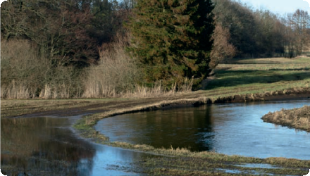
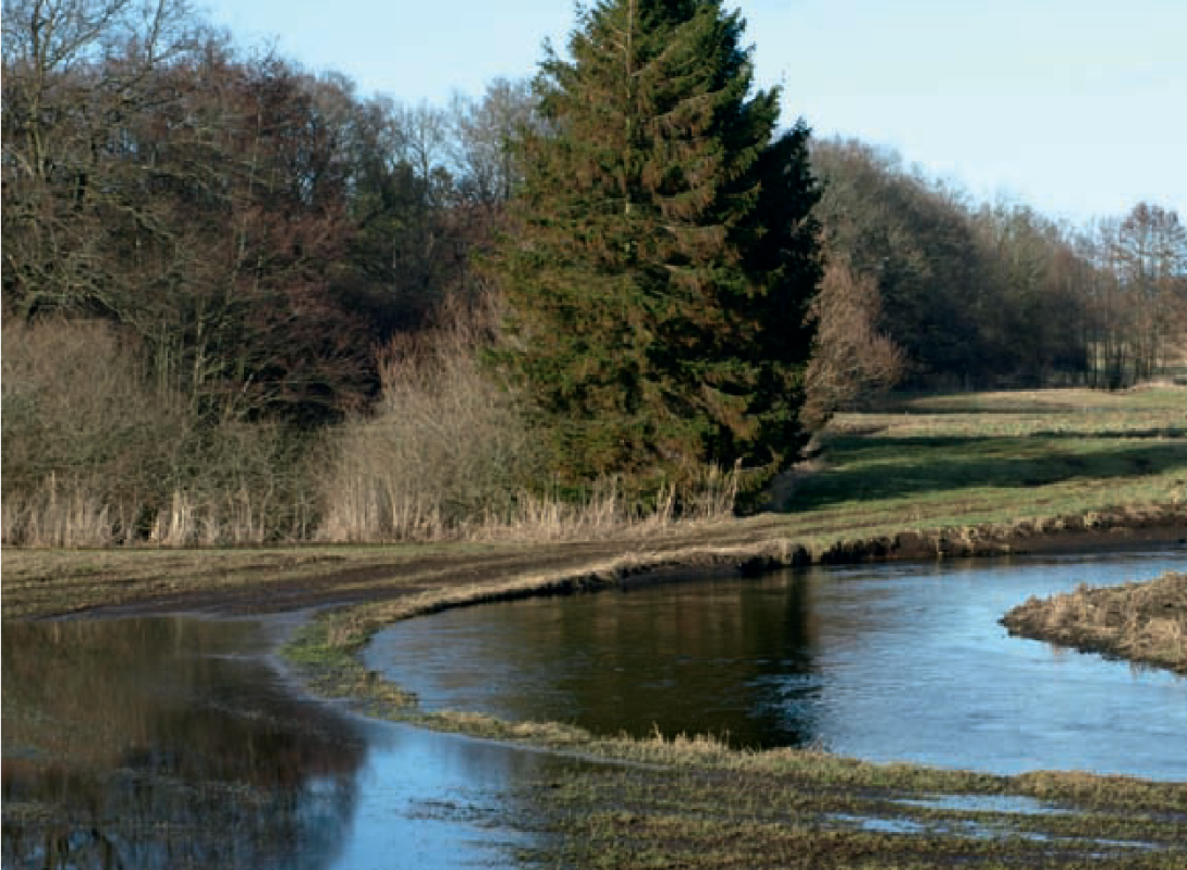
The Odense is a river in southern Denmark. It was channelized and deepened in the late 1940s to improve agriculture. The NWRM consists of a series of measures to restore floodplain connectivity along a 17 km section of the river. The measures will prevent flooding in downstream towns and cities. This will have a number of effects on the pressures relevant for the WFD. Reduced risk for flooding of urban environment reduces the risk for storm overflows from sewers as well as diffuse pollution resulting from flooding in general. Re-meandering reduces the pressure from previous physical alterations for flood protection and agricultural purposes. It will also potentially have a positive effect on ground water recharge in temporarily flooded areas.
Since 2004, ~12 km of Odense River have been remeandered and 350 ha of wetlands restored under LIFE REGAIN. Recent actions include removal of migration barriers, and mussel habitat restoration.
In 2024, two artificial stone reefs (4500 tonnes) were established in Odense Fjord to enhance marine biodiversity. The project was led by SDU in partnership with Odense and Nordfyn municipalities and Aage V. Jensen Naturfond. The reefs aim to improve conditions for fish fry, seagrass, and aquatic invertebrates, and contribute to the ecological recovery of the fjord.
Position
Latitude
55.2196
Longitude
10.2824
Project
NWRM
National Id
Denmark_01
Installation date
2003
Implementation Status
Contact
Mats Ivarsson, Enveco
RBD code
DK1
Transboundary
0
Photo gallery
Location of the project
The Odense is a river in southern Denmark. The project consists of a series of measures to restore floodplain connectivity along a 17 km section of the river.
NUTS Code
DK03 - Syddanmark
Project's objectives
Regulation of the chemical status of freshwater
Flood control and flood risk mitigation
Biodiversity and gene-pool conservation in riparian areas
Flood control and flood risk mitigation
Biodiversity and gene-pool conservation in riparian areas
Involved Partners
| Authority type | Authority name | Role | Comments |
|---|---|---|---|
Climate zone
cool temperate moist
Temperature
8,2
Precipitation
727
Annual rainfall range
600 - 900 mm
Runoff
316
Runoff coefficient range
0.3 - 0.5
Runoff range
300 - 450 mm
Imperviousness range
10 - 20%
Elevation range
26
Slope range
very gentle (1-2%)
Soil type
Fluvisol
Water bodies: Ecological Status
Good
Water bodies: Chemical Status
Unkown
Project scale
Large
Project scale specification
The area affected by flooding during extreme precipitation events was for the investigated river stretch 43,8 ha.
Performance timescale
5 - 10 years
Project area
43,8
Area specifications
The area affected by flooding during extreme precipitation events was for the investigated river stretch 43,8 ha. If the remaining 95% of restored river stretch behaves in the same manner, the figure only represents 5% of the entire area affected. The entire area affected by the measure consists of 78 ha.
Area subject to Land use change or Management/Practice change (ha)
125
The area affected by flooding during extreme precipitation events was for the investigated river stretch 43,8 ha. If the remaining 95% of restored river stretch behaves in the same manner, the figure only represents 5% of the entire area affected.
Design capacity description
Maximum water detention capacity for the investigated part of the restored river stretch (5%): 3648 m3. If it is assumed thar the remaining 95% of the restored river stretch behave in the same manner, this figure thus represents 5% of the total water volume that can be detained.
The land use in affected areas have to be transformed permanently from e.g. intensively cultivated land to grazed meadows. This will induce a cost to the farmer which requires compensation, either by an annual compensation based on market values for crops or some other metric, or by land aquisition. Re-meandering and creation of wetlands might also be in conflict with infrastructure and residential or commersial housing.
The evident need to mitigate the effects of the re-occuring flooding events in the downstream towns and villages in the catchment area, together with the availability of land for the purpose of floodplain restauration and wetland creation.
Total cost
€ 635,976
Costs total information
14,520 €/ha.
The whole LIFE REGAIN project had a total eligible budget of 3,852,367 €. The more recent UC LIFE Denmark project (for mussel habitat restoration) has a total eligible budget of 2,077,261 €
The whole LIFE REGAIN project had a total eligible budget of 3,852,367 €. The more recent UC LIFE Denmark project (for mussel habitat restoration) has a total eligible budget of 2,077,261 €
Costs capital information
3 120 €/ha
Costs land acquisition
11400
Costs land acquisition unit
€/ha
Costs land acquisition information
In 2014 prices
Costs operation maintenance information
Not available
Economic costs, actual income loss
The average decrease in income from farm operations due to the conversion from arable land to grazed meadows of land adjacent to the river has been assessed to €11 400/ha.
Financing authorities
Type of funding
Sub-national funds
Comments
As time went by, the land prices became higher and higher and in the end the County had to hold the remaining financing on top of the Danish Nature Agency.
Type of funding
EU-funds: LIFE+
Comments
1,926,184 € for the LIFE04 NAT/DK/000022 (LIFE REGAIN) project
Type of funding
EU-funds: LIFE+
Comments
1,246,356 € for the LIFE15 NAT/DK/000948 (UC LIFE Denmark) project
Policy context
The measure will prevent flooding in downtream towns and cities. This will have a number of effects on the pressures relevant for the WFD. Reduced risk for flooding of urban environment reduces the risk for storm overflows from sewers ( PN 1.1) aswell as diffuse pollution resulting from flooding in general (PN 2.1). Re-meandering reduces the pressure from previous physical alterations for flood protection and agricultural purposes (PN 4.1.1 and 4.1.2). It will also potentially have a positive effect on ground water recharge in temporarily flooded areas (PN 6.1).
Land ownership
Over 70 landowners involved, with grazing agreements for 150 ha.
Community involvment
No
Design consultation activity
| Activity stage | Name | Key issues | Comments |
|---|
Policy target
| Target purpose |
|---|
|
Peak-flow reduction
|
|
Improved Biodiversity
|
|
Pollutants Removal
|
Policy pressure
| Pressure directive | Relevant pressure |
|---|---|
|
WFD identified pressure
|
4.1.2 Physical alteration for agriculture
|
|
Floods Directive identified pressure
|
Natural Exceedance
|
Policy impact
| Impact directive | Relevant impact |
|---|---|
|
WFD identified impact
|
Altered habitat due to hydrological change
|
|
Floods Directive identified impact
|
Waterbody status
|
Requirement directive
| Requirement directive | Specification |
|---|---|
|
WFD-achievement of good ecological status
|
|
|
Floods Directive-mitigating Flood Risk
|
Contractual arrangements
1
| Arrangement type | Responsibility | Role | Name | Comments |
|---|---|---|---|---|
|
Land management based on voluntary agreements.
|
Grazing agreements.
|
Signed for ~150 ha.
|
Part of wider plan
1
Wider plan type
| Wider plan type | Wider plan focus | Name | Comments |
|---|---|---|---|
|
National
|
Environment & Biodiversity
|
National action plan II for the aquatic environment
|
1998 plan. The objective was to restore 16.000 ha of wetlands in Denmark to retain nitrogen. The application was finaced by a state program under the Danish Nature Agency.
|
Ongoing monitoring of flows and riparian inundation could help to validate the modelling results used to justify this measure.
Maintenance
No maintenance required
Laboratory
Exploration of the linkages between floodplain hydraulics and in situ observed sedimentationpatterns by: (i) performing a validation of a dynamic 2D river andfloodplain model based on in situ measurements of water depth and flow velocity for a section of a re-meandered 5th order Danishriver channel and floodplain; (ii) compare floodplain flow velocities with measured net deposition of sediment, phosphorus and organicmatter; and (iii) test if simple empirical relationships between floodplain hydraulics and sediment deposition could be developed.
Biophysical impacts were assessed by a combination of modelling and observational studies. Modelling was performed to assess the flow patterns in the floodplains while observational studies were performed to assess the amount of sediment and nutrients deposited.
Cost information were provided by Claus Paludan at the municipality of Faaborg-Midtfyn No information was available on the assessment of cost effectiveness of measures.
There are no monetary valuation of the direct benefits accruing from the re-meandering and wetlands available. Qualitatively, the direct benefits can be described as reduced risk for flooding in down stream villages, towns and land adjacent to the Odense Å during events of extreme precipitation.
The aditional benefits from this measure are connected to the reduction of nutrient leakage and consequent eutrophication in the Odense Å and in the coastal water receiving the river discharge. The riverbed restoration also bring about a strengthened biodiversity as migrating fish and benthos return to the stream. Positive effects can also be anticipated on cultural ecosystem services such as recreation in the affected areas.
Hydrological effects
Wetland restoration (~860 ha total) increased water retention and restored floodplain dynamics. Overbank flooding is re-enabled in remeandered sections.
Information on retained water
At maximum water detention, approximately 3650 m3 are detained in the investigated area (%5 of the restored river stretch). Assuming that the remaing 95% of the restored river stretch behave in the same manner, the correct figure would be 72 960 m3.
Information on increased water storage
Since the storage is done in temporary wetlands formed during events of extreme precipitation and consequent flooding of grazing meadows (previously cultivated land) the entire volume can be considered to be an increase compared to the previous situation.
Information on Peak flow rate reduction
The measure has led to a reduction in peak flow during events of extreme precipitation.
Information on Restoring hydraulic connections
Barrier removal reconnected 3.1 km of river, improving fish and Unio crassus migration. Longitudinal continuity was partially restored.
Water quality overall improvements
Positive impact-WQ improvement
Information on Water quality overall improvements
The measurzeaffected water quality insofar as it led to increased deposition of sediment, phosphorus and organic matter on the floodplain as well as removal of nitrogen in the wetlands along the re-meandered river stretch.
Water quality Improvements Nitrogen (N)
39
Wq Improvements n unit
% reduction pf pollutant
Information on Water quality Improvements (N)
An estimate of 235 kg N/ha/yr is removed in the wetlands along the re-meandered river stretch. Restored wetlands reduced nitrogen exports by ~124 t/year. Overall, a 39% N-load reduction (–377 t/year) was measured between 2000–2015.
Soil quality overall soil improvements
N/A info
1
Restoration of riverbeds and re-meandering are themselves measures that strengthen biodiversity in terms of improved biotopes for stream benthos. The periodical flooding of wetlands in connection to the restored river enhances this effect for a number of species, both flora and fauna.
Ecosystem impact climate regulation
Reduced energy use (farm operations)
Information on Ecosystem impact climate regulation
The conversion from arable land to grazed meadows of land adjacent to the river will result in decreased energy use in farm operations.
Ecosystem provisioning services
0
Key lessons
Water detention through temporary flooding of wetlands can play a significant role in cutting of flow peaks, and thereby decreasing water levels and floodrisk in downstream towns and villages during incidents of extreme precipitation.
Success factor(s)
| Success factor type | Success factor role | Comments | Order |
|---|---|---|---|
|
Specific incentives for stakeholder involvement
|
main factor
|
The "toolbox" offered contained several measures (including land consolidation). The project succeded in establishing voluntary agreements with and among the landowners in this project. |
Driver
| Driver type | Driver role | Comments | Order |
|---|---|---|---|
|
Other
|
main driver
|
The financial support of the Danish Nature Agency through the national plan for the aquatic environment together with the initiative from the former Danish Counties played a cruicial part for enabling the project.
|
1
|
Flexibility adaptability
There may be a potential to adapt the measure to changing baseline conditions either through additional remeandering or further work on the channel bottom.
Transferability
Some elements of the measures implemented here are transferrable to many agricultural rivers throughout north and central Europe. In any place where historical channelization has disconnected rivers from floodplains, a potential may exist for measures which reconnect the river and its floodplain.
Cost effectiveness
No “traditional / structural” methods are available to achieve the floodplain reconnectivity accomplished by the Odense measures, thus it is very difficult to make this comparison.
English