Last update
2025
Summary
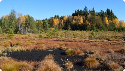
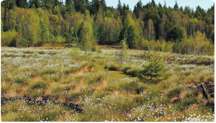
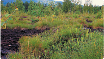
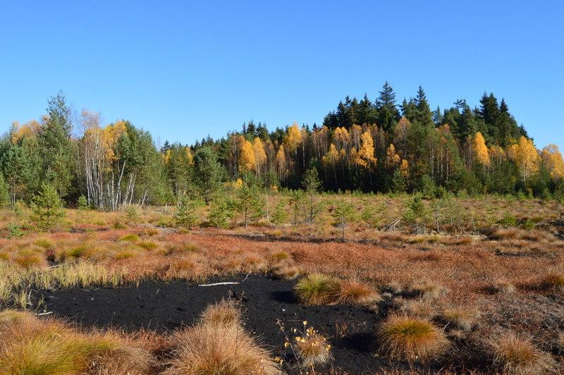
Soumarský Most (Šumava NP) is a raised bog once almost destroyed by industrial peat mining. In 2004, the park and local authorities restored the site with national funding, re-establishing wetland and peat-forming vegetation and improving the water regime; hydrology and vegetation were monitored from 2000–2011. Soumarský Most is the first former industrial restored bog in the Sumava region. Since then, outcomes are visible on the ground: a 1.5-km nature trail opened in 2012 to interpret the restoration, and in 2022 the boardwalk had to be rebuilt as groundwater has steadily risen for nearly two decades : evidence the rewetting is functioning. In June 2025 the wooden lookout tower was closed for safety and is being redesigned; the trail remains open. Biodiversity has responded: 371 moth and butterfly species were documented in 2011–2016, including bog specialists recolonising from nearby peatlands. Community involvement continues, e.g., volunteers built peat dams on drainage channels in 2019 to further raise water levels. Overall, Soumarský Most shows lasting hydrological recovery and conservation benefits following peatland restoration.
Position
Latitude
48.9125
Longitude
13.82583
Project
NWRM
National Id
Czech_4
Installation date
2004
Implementation Status
Contact
REC
Transboundary
0
Photo gallery
Location of the project
On the left bank of the Teplá Vltava near the hamlet Soumarský Most, ~0.5 km off Road I/39 (Volary → Lenora); the trail starts by the Soumarský Most campsite/rail halt.
NUTS Code
CZ03 - Jihozápad
Project's objectives
Rewet the mined bog using the Target Water Table concept; block and infill drainage ditches, re-establish natural water flows, and reintroduce peat-forming species (Sphagnum, Eriophorum, Carex rostrata). Implementation metrics recorded for this site: ~500 dams and ~9 km of ditches blocked over ~55 ha (2003–2004).
Involved Partners
| Authority type | Authority name | Role | Comments |
|---|---|---|---|
Climate zone
cool temperate moist
Temperature
6,2
Precipitation
760
Annual rainfall range
600 - 900 mm
Runoff coefficient
0,1
Elevation range
780 m
Slope range
<2
Vegetation class
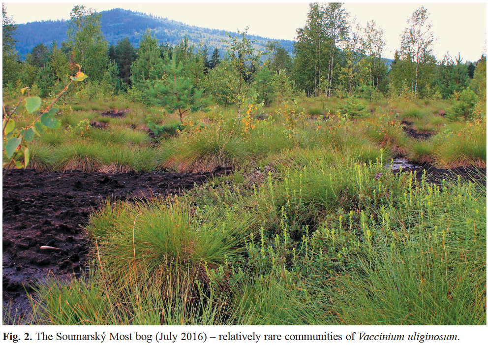
Bog pine (Pinus rotundata) forest and dwarf shrub vegetation dominated by Vaccinium uliginosum.
Water bodies: Ecological Status
Moderate
Water bodies: Chemical Status
Failing to achieve good
Water quality status
the principal pressure was industrial peat mining and drainage
Project scale
Micro
Project scale specification
single site; restoration focused on a specific mined bog of tens of hectares
Project area
53 ha
Drainage removal / check-dam system: Historical drainage rills and ditches were blocked with a system of wooden/peat check dams and by ditch infilling to lift and level the water table. (This is documented for Soumarský Most in NP materials and the site-focused diploma thesis; public sources do not state a verified dam count for this site.)
Artificial shallow depressions (“pools”) were created locally to retain surface water and provide early wet microhabitats on the mined surface.
Mulching of bare peat with cut biomass from nearby peat-meadows (e.g., Malá niva / Stožecké louky area) to suppress evaporation, buffer temperature, and carry diaspores; Sphagnum pieces were also hand-placed in wet spots.
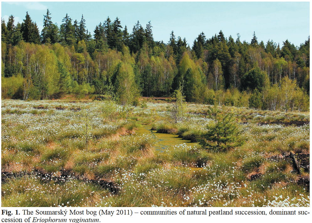
Assisted revegetation trials: reintroductions of Carex rostrata and Eriophorum angustifolium, plus broadcasting of Sphagnum, were tested at Soumarský Most; natural expansion of Eriophorum vaginatum was recorded in the first decade post-restoration.
Selective removal of self-seeded trees on parts of the mined field to keep the surface open and wet during early phases (reported in the site thesis’ restoration chapter).
Visitor infrastructure adapted to wetter ground: a 1.5 km educational trail with a 9.2 m wooden lookout tower.
Artificial shallow depressions (“pools”) were created locally to retain surface water and provide early wet microhabitats on the mined surface.
Mulching of bare peat with cut biomass from nearby peat-meadows (e.g., Malá niva / Stožecké louky area) to suppress evaporation, buffer temperature, and carry diaspores; Sphagnum pieces were also hand-placed in wet spots.
Assisted revegetation trials: reintroductions of Carex rostrata and Eriophorum angustifolium, plus broadcasting of Sphagnum, were tested at Soumarský Most; natural expansion of Eriophorum vaginatum was recorded in the first decade post-restoration.
Selective removal of self-seeded trees on parts of the mined field to keep the surface open and wet during early phases (reported in the site thesis’ restoration chapter).
Visitor infrastructure adapted to wetter ground: a 1.5 km educational trail with a 9.2 m wooden lookout tower.
Total cost
€169,229
Costs total information
3193€/ha for the initial resoration
Further developments (touristic paths, lookout tower, etc.) are not included.
Further developments (touristic paths, lookout tower, etc.) are not included.
Financing authorities
Type of funding
Sub-national funds
Comments
Management programmes, Sumava NP and PLA Authority
Compensations
0
Policy context
A raised bog almost completely destroyed by industrial peat mining and drainage; the programme’s aim was to rewet and restart peat-forming processes. This aligns with WFD hydromorphological alteration from drainage & channelization.
Land ownership
The land belongs to the town of Volary; the NP administration manages public access and conservation via agreements/lease.
Community involvment
Yes
Design consultation activity
| Activity stage | Name | Key issues | Comments |
|---|---|---|---|
|
Other
|
Tourist information point
|
with connection to the nearby Vltava river floodplain.
|
Policy target
| Target purpose |
|---|
|
Improved Biodiversity
|
Policy pressure
| Pressure directive | Relevant pressure |
|---|
Policy impact
| Impact directive | Relevant impact |
|---|
Requirement directive
| Requirement directive | Specification |
|---|
Contractual arrangements
0
| Arrangement type | Responsibility | Role | Name | Comments |
|---|
Part of wider plan
0
Wider plan type
| Wider plan type | Wider plan focus | Name | Comments |
|---|
Šumava NP has run long-term hydrology and vegetation monitoring here (documented 2000–2011 and continued within the park’s programme since 2005).
Within the Šumava NP mire-monitoring framework, key variables include water table, hydrochemistry (pH, conductivity, DOC, SO₄, NO₃, NH₄, PO₄, Ca, Mg, Al, Fe), vegetation, and microclimate (air/soil temperature & moisture); these underpin evaluations of restoration success at restored bogs like Soumarský Most.
Maintenance
Low-intensity, episodic works led by Šumava NP—e.g., 2024 central-canal blocking and peat infill plus ongoing boardwalk upkeep, to protect the recovering mire and guide visitors.
Catchment outlet
Continuous hydrology and vegetation monitoring between 2000 and 2011
Visitor infrastructure investment: the 2022 boardwalk project cost CZK 4.5 million (excl. VAT); the trail concentrates visitors away from recovering peat surfaces. (Tower closed in 2025 for safety; new one planned.). It supports eco-tourism while concentrating footfall; volunteer events and work with the municipality of Volary accompanied the restoration.
Information on retained water
Groundwater has risen progressively for ~20 years following the 2001–2004 re-wetting (ditch blocking and mulching). Šumava NP states that “for almost 20 years since revitalisation, water has been gradually returning,” to the point the trail could no longer be crossed “dry-foot.” This sustained high water forced a full boardwalk rebuild in Aug–Oct 2022, officially justified by the damage from rising groundwater; access was temporarily closed. Persistent wetness also contributed to structural rot of the viewing tower, which the park closed in 2025 pending a replacement. While a tourism facility issue, it evidences continuously wet conditions on site.
1
Sphagnum mosses were reintroduced, especially into the shallow basins. The initial vegetation was dominated by wetland species growing mostly on the wet bases of the draining dithces.
Lepidoptera: 371 moth and butterfly species recorded in 2011–2016 at Soumarský Most; specialists (tyrphobionts/tyrphophiles) are recolonising from nearby pristine bogs in Vltavský Luh.
Fungi: 2017–2021 fruit-body surveys at Soumarský Most found few target peatland indicator taxa (e.g., Sarcoleotia turficola, Cortinarius tubarius), but the site is mycologically valuable—indicative of early-to-intermediate successional recovery.
Protected fauna context: seasonal access closures remain to protect black grouse (tetřívek) using the area.
Information on Other biophysical impacts
Post-rewetting, the NP reports the bog “again retains water, cools the landscape and stores carbon,” reversing the prior heat-island effect and peat oxidation after mining. (Qualitative, management source.)
Key lessons
Restoring the water regime is the decisive driver: re-saturating the mined bog enabled peat-forming vegetation to re-establish and habitats to recover. As the original NWRM note states, successful regeneration hinged on water regime, and vegetation patterns in flooded areas depend on water-table height, remaining peat depth, and successional age.
At this site, full ditch blocking + infilling and surface mulching proved complementary: blocking raised/leveled the water table, while mulch reduced evaporation and protected diaspores, accelerating Sphagnum and sedge establishment.
Long-term effects matter. The water table has risen progressively over ~20 years, a visible indicator of hydrologic recovery (necessitating a full boardwalk rebuild in 2022 and a tower closure in 2025). Monitoring and adaptive visitor-management are therefore integral to sustaining outcomes.
Biodiversity responds when hydrology is fixed: post-restoration surveys recorded 371 Lepidoptera species, including bog specialists recolonising from nearby intact mires—evidence that specialist taxa can return if wet conditions persist.
Success factor(s)
| Success factor type | Success factor role | Comments | Order |
|---|---|---|---|
|
Financing possibilities
|
main factor
|
National funding and support from Šumava NP & local authorities |
1
|
|
Conducted assessments (incl. economic)
|
secondary factor
|
Long-term monitoring enabling adaptive management |
|
|
Public participation
|
main factor
|
Visitor infrastructure to protect recovering surfaces |
Driver
| Driver type | Driver role | Comments | Order |
|---|---|---|---|
|
Organisation committed to it
|
main driver
|
Authority of the Natural Park
|
1
|
|
Availability of subsidies
|
secondary driver
|
2
|
|
|
Legal obligations
|
secondary driver
|
Strategy programes
|
3
|
Transferability
Highly transferable to post-mining bogs: block and infill drains, then mulch to kick-start peat vegetation. Calibrate a site-specific target water level, ensure biomass supply for mulch, and design/maintain visitor access for wetter ground. Continuous monitoring is essential to adapt works.
Source(s)
English